INTERACTIVE CONTEXT MAP
Where is Ozark Plateau?
The selected plateau and nearby mapped locations are shown. Open the full world atlas to explore every region.
Interior Highlands of the United States
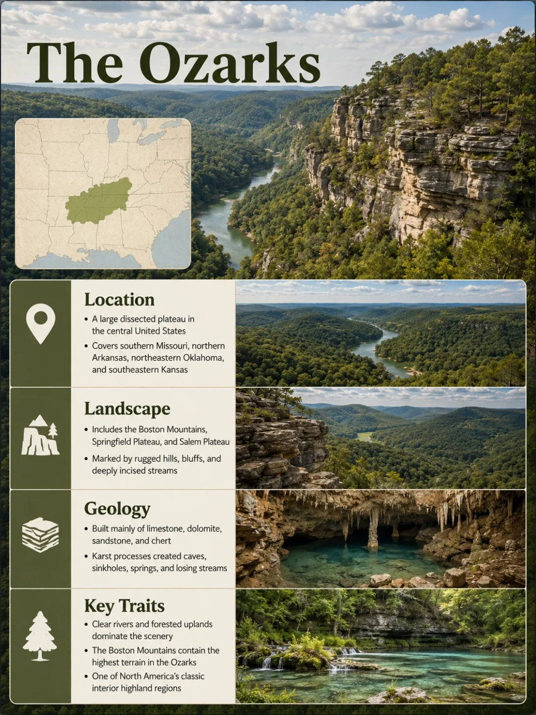
The Ozark Plateau is a broad, deeply eroded upland centered on southern Missouri and northern Arkansas, with smaller extensions into northeastern Oklahoma and southeastern Kansas. Its wooded ridges, steep valleys, caves and springs can look mountainous from the ground, yet much of the region is a dissected plateau: an older elevated surface cut apart by rivers, weathering and the dissolution of carbonate rock.
Dissected interior plateau
Highest point: 2,561 ft / 781 m
A Four-State Plateau With an Uneven Footprint
The Ozark Plateau lies within the Interior Highlands of the south-central United States. Missouri and Arkansas contain most of the recognizable Ozark uplands. The province continues westward into northeastern Oklahoma and reaches a much smaller area of southeastern Kansas.
The plateau does not follow state lines, and the familiar cultural region called the Ozarks does not always use exactly the same boundary as the physiographic province. A widely used U.S. Geological Survey treatment places the Ozark Plateaus Province at roughly 40,000 square miles, while broader hydrologic study areas can be considerably larger because they include adjoining groundwater and drainage zones.
| State | Ozark Setting | Geographic Character |
|---|---|---|
| Missouri | Large northern and eastern core | Extensive Salem and Springfield Plateau terrain, major karst areas and the St. Francois igneous highlands |
| Arkansas | Large southern core | Salem and Springfield surfaces rising southward toward the deeply dissected Boston Mountains |
| Oklahoma | Smaller western and southwestern extension | Ozark terrain in the northeast, including plateau and karst landscapes connected to the Arkansas and Missouri sectors |
| Kansas | Small northwestern fringe | A limited southeastern extension associated mainly with the Springfield Plateau margin |
Geography Note
The Ozarks can refer to a broader regional and cultural landscape, while Ozark Plateaus Province is a physiographic term. Area figures and boundaries can differ depending on which definition a map or dataset uses.
Ozark Plateau, Ozark Plateaus and Ozark Mountains
Several names are used for the same broad highland region, but they emphasize different things. Ozark Plateau is common in general geography. Ozark Plateaus appears frequently in formal U.S. physiographic and hydrologic work because the region contains several distinct plateau surfaces rather than one uniform tableland.
Ozark Mountains is also a well-established regional name. It describes the rugged appearance of the landscape, especially where streams have cut deep valleys between narrow, high ridges. The name does not mean that the entire Ozarks formed as a conventional folded mountain belt.
Typical Folded Mountain Belt
- Relief closely tied to crustal compression, folding or major faulting
- Long mountain ridges may follow strongly deformed rock structures
- Peaks and ranges are the primary regional landform
Much of the Ozark Plateau
- Broad uplift followed by long erosion and stream incision
- Many sedimentary layers remain nearly horizontal or gently inclined
- Ridges commonly represent remnants of an older dissected upland surface
The Boston Mountains are a good example of this distinction. Their name and rugged relief suggest a mountain range, but physiographically they form the high, deeply dissected southern part of the Ozark plateau system.
The Ozarks Are Built From Several Distinct Upland Levels
The Ozark landscape changes noticeably from one part of the province to another. Rock age, rock type, elevation and resistance to erosion combine to produce several recognizable physiographic sections.
| Section | Relative Position | Characteristic Surface Rocks | Typical Landscape Expression |
|---|---|---|---|
| Salem Plateau | Lower, broad plateau surface | Mainly Ordovician dolostone, limestone and sandstone | Dissected uplands, spring systems, caves and deeply cut stream valleys |
| Springfield Plateau | Intermediate surface above much of the Salem Plateau | Mississippian limestone and chert are widespread | Rolling uplands, karst, sinkholes, caves, solution valleys and dissected margins |
| Boston Mountains | Highest southern plateau section | Pennsylvanian sandstone, shale and siltstone | Flat-crested ridges, steep slopes and deep V-shaped valleys |
| St. Francois Mountains | Ancient exposed core in southeastern Missouri | Precambrian igneous rocks, especially granite and rhyolite | Rounded resistant peaks rising from the older structural core of the Ozark uplift |
Classification Detail
Not every physiographic source counts the sections in exactly the same way. Many descriptions use Salem Plateau, Springfield Plateau and Boston Mountains as the three main plateau sections. Classic Fenneman-based physiography also recognizes the St. Francois Mountains as a separate section within the broader Ozark Plateaus Province.
Salem Plateau
The Salem Plateau occupies a large part of the central and eastern Ozarks. In northern Arkansas it forms the lowest of the three main plateau surfaces and exposes older Ordovician rocks than those dominating the Springfield Plateau and Boston Mountains.
Dolostone and limestone make carbonate dissolution an important landscape process. Streams have cut into the plateau, while groundwater has enlarged fractures and bedding-plane openings below the surface. This combination helps produce the springs, caves and irregular valleys associated with much of the Salem terrain.
Springfield Plateau
The Springfield Plateau generally stands above the Salem surface and extends across southwestern Missouri, northwestern Arkansas and adjoining parts of Oklahoma and Kansas. Mississippian limestone, commonly associated with chert, forms much of its surface geology.
Some parts are gently rolling, while others have been strongly dissected. Karst is widespread, so surface drainage can be interrupted by sinkholes, losing streams and underground flow paths.
Boston Mountains
The Boston Mountains form the high southern edge of the Ozark system, mainly across northern Arkansas with continuation westward toward Oklahoma. Resistant sandstone and associated shale and siltstone help preserve high ridge surfaces while streams cut narrow valleys deeply into the plateau.
A recent U.S. Geological Survey description characterizes the Boston Mountains as an eroded and uplifted southern extension of the Ozark Plateau about 200 miles east to west and roughly 35 miles north to south. Local relief from valley floors to ridgetops commonly reaches several hundred feet and can approach 1,500 feet in the more rugged terrain.
St. Francois Mountains
The St. Francois Mountains of southeastern Missouri are different from the sedimentary plateau surfaces around them. They expose resistant Precambrian granite and rhyolite from the ancient structural core of the Ozark uplift.
These rocks are far older than the Paleozoic carbonate and clastic layers covering much of the surrounding province. Their survival at the surface provides one of the clearest windows into the basement beneath the Ozarks.
How a Broad Uplift Became a Dissected Plateau
The present Ozark landscape developed through several different processes rather than one short episode of mountain building. Its modern form reflects ancient igneous basement, long periods of sediment deposition, broad regional uplift and prolonged erosion.
Precambrian igneous rocks formed the old foundation now exposed most clearly in the St. Francois Mountains.
Shallow seas and later depositional environments laid down thick sequences of dolostone, limestone, sandstone, shale, chert and related rocks.
The region developed into a broad structural high. Sedimentary strata generally dip away from the uplifted core rather than forming a tightly folded mountain chain.
Streams cut downward into the elevated surface, leaving ridges, escarpments and plateau remnants between growing valley networks.
The broad structure is commonly described as a dome or uplift. Its axis runs through the Ozark interior toward the St. Francois Mountains. Erosion stripped younger rocks from higher parts of the uplift and exposed progressively older strata toward parts of the structural core.
This is why the Ozarks contain both a recognizable regional highland and many different local landscapes. The plateau surface was not preserved as one flat sheet. Rivers and weathering broke it into an intricate network of ridges, hollows and valleys.
Why the Plateau Can Look More Like a Mountain Region
The word plateau can suggest a wide, nearly level surface, but strong dissection can remove much of that appearance. In the Ozarks, valleys have cut deeply enough that a person standing near a river may see steep wooded slopes on both sides and little evidence of a broad plateau surface.
A broader elevated surface existed before extensive valley cutting.
Rivers and tributaries cut downward and expanded drainage networks.
Remnant uplands now stand as narrow ridges above deep valleys, producing a mountain-like profile.
The Boston Mountains show the pattern especially well. High crests can remain relatively flat or gently rounded even while nearby streams occupy narrow V-shaped valleys far below. The relief comes largely from removal of rock between the upland remnants, not from every ridge being pushed upward as an individual mountain.
Elevation Changes Across the Ozarks
There is no single useful “elevation of the Ozark Plateau.” The province contains low valley corridors, intermediate rolling surfaces, high ridges and isolated resistant peaks.
The Salem Plateau generally represents a lower physiographic level than the Springfield Plateau, while the Boston Mountains rise above both along the southern part of the province. In northern Arkansas, the change can be read as a broad step upward from Salem terrain through the Springfield surface to the high Boston Mountains.
Wahzhazhe Summit
About 781 m above sea level and identified by the U.S. Geological Survey as the maximum elevation of the Boston Mountains and the Ozark Plateau.
Highest Plateau Sector
The southern Ozarks contain the highest and some of the most deeply dissected terrain in the province.
Wahzhazhe Summit is in Newton County, Arkansas, within the Ozark National Forest. The name was approved after the feature had also been known as Buffalo Lookout. Its elevation is 2,561 feet above sea level using the North American Vertical Datum of 1988.
Elevation Mix-Up
Arkansas’s highest point is Mount Magazine, but Mount Magazine is south of the Ozark Plateaus in the Arkansas Valley physiographic section. It should not be used as the highest elevation of the Ozark Plateau.
Karst Changes Both the Surface and the Underground Landscape
Carbonate bedrock gives large parts of the Ozarks a second drainage system beneath the visible one. Limestone and dolostone slowly dissolve when slightly acidic groundwater moves through joints, fractures and bedding planes. Over time, small openings can grow into conduits, caves and large spring systems.
The result is a landscape where surface water and groundwater are tightly connected. A stream may lose water into openings in its bed, flow underground through carbonate rock and reappear at a spring some distance away.
Closed depressions form where soluble rock dissolves or where material settles into underground openings.
Some stream reaches leak substantial amounts of water through fractured or dissolved carbonate bedrock.
Groundwater enlarges connected openings into underground passage systems that may preserve evidence of older drainage levels.
Concentrated groundwater returns to the surface where underground conduits intersect valleys or other discharge zones.
Karst is not equally developed everywhere. Modern hydrogeologic work shows especially strong karst development in the Salem Plateau and in the northern Springfield Plateau. Differences in carbonate purity, weathered surface material and rock structure can change how readily water enters and moves through the bedrock.
The Boston Mountains behave differently. Sandstone, shale and siltstone are more prominent there, and surface-water and groundwater interaction is generally weaker than in the carbonate-dominated Salem and Springfield sections.
Karst Is Not Uniform Across the Ozarks
Caves, springs and sinkholes are defining Ozark features, but they should not be treated as if they occur with the same density throughout the province. Bedrock changes sharply between plateau sections, and the landscape changes with it.
Rivers Have Cut the Plateau Into Separate Uplands
The modern shape of the Ozarks cannot be separated from its drainage network. Major rivers and hundreds of tributaries have removed rock from the uplift for long periods, deepening valleys and separating once-broader surfaces into ridges and upland blocks.
Important drainage systems within or crossing the province include the White, Buffalo, Current, Eleven Point, Gasconade, Meramec, Black, St. Francis, Illinois, Neosho and Osage systems. They ultimately connect the Ozarks to larger Mississippi, Missouri and Arkansas River drainage networks.
Different rocks produce different valley forms. Resistant sandstone in the Boston Mountains helps maintain steep walls and high narrow ridges. Carbonate terrain elsewhere adds underground drainage to the normal surface network, so valley development can involve both river incision and dissolution below ground.
The Buffalo River corridor in northern Arkansas provides a clear transition through Ozark terrain. Its headwaters lie in the high Boston Mountains, while downstream reaches cross lower plateau surfaces. The river therefore cuts through several rock units and physiographic levels as it moves toward the White River.
Rock Type Explains Many of the Ozarks’ Sharp Landscape Changes
Traveling across the Ozarks can produce abrupt changes from rolling uplands to bluff-lined valleys, karst depressions or rugged high ridges. These changes often follow the underlying rock more closely than state or county boundaries.
| Rock | Landscape Effect | Common Ozark Expression |
|---|---|---|
| Limestone | Dissolves relatively readily in weakly acidic groundwater | Caves, sinkholes, springs, solution valleys and bluffs |
| Dolostone | Can develop karst while also forming resistant ledges and valley walls | Salem Plateau springs, dissected valleys and carbonate uplands |
| Chert | Resists chemical weathering more strongly than surrounding carbonate material | Rocky soils, residual fragments and chert-rich Springfield Plateau surfaces |
| Sandstone | Resistant beds can protect high surfaces and form cliffs | Boston Mountain ridge caps, steep slopes and bluff-forming layers |
| Shale and Siltstone | Generally weather more readily than resistant sandstone | Slopes, benches and layered valley sides beneath harder beds |
| Granite and Rhyolite | Hard Precambrian igneous rocks resist erosion | St. Francois Mountains and exposed remnants of the Ozark uplift’s ancient core |
The St. Francois Core Reveals the Deeper Structure of the Ozarks
The St. Francois Mountains are more than a rugged corner of the Missouri Ozarks. They expose rocks that help explain the geometry of the entire uplift.
Precambrian crystalline rocks form the basement beneath the region and reach the surface in the St. Francois area. Around this old core, younger Paleozoic sedimentary rocks generally dip away from the structural high. Erosion has removed much of the former sedimentary cover above the core, revealing granite and rhyolite that would otherwise remain buried.
This creates a useful distinction within the Ozarks. The Salem, Springfield and Boston sections are largely understood through sedimentary plateau surfaces and their erosion. The St. Francois Mountains preserve resistant igneous remnants from a much older geological foundation.
A Two-Million-Year Cave Record Adds a Clock to Ozark Erosion
The general idea that rivers carved the Ozarks has been known for a long time, but recent research has placed tighter dates on part of that landscape evolution. A 2025 study of Fitton Cave, beside the Buffalo River in northern Arkansas, used several dating methods on cave sediment and mineral deposits to reconstruct changes in the southern Ozark Plateau.
Coarse sediment entered high cave passages about 2.2 million years ago and again around 1.25 million years ago. These deposits are the oldest documented epigenetic cave sediments of their kind in the region. Younger passages formed as the surrounding drainage system continued to cut downward.
Measured Valley Incision
The Fitton Cave study estimated an average valley-incision rate of about 27 meters per million years since roughly 0.85 million years ago. The value applies to the studied Buffalo River–Fitton Cave setting and should not be treated as one uniform erosion rate for the entire Ozark Plateau.
The cave record also links underground passage levels with changes in the surface valley. As the Buffalo River system lowered its valley floor, groundwater routes adjusted to new base levels and abandoned some higher cave passages. Sediment left behind in those passages now records former stages of the landscape that are no longer visible at the surface.
The dated sediments also suggest that colder Pleistocene climate conditions influenced sediment supply in the southern Ozarks, even though the major Laurentide ice sheets remained far to the north. This makes the caves useful archives not only of karst development but also of how climate, sediment movement and river incision interacted as the plateau continued to evolve.