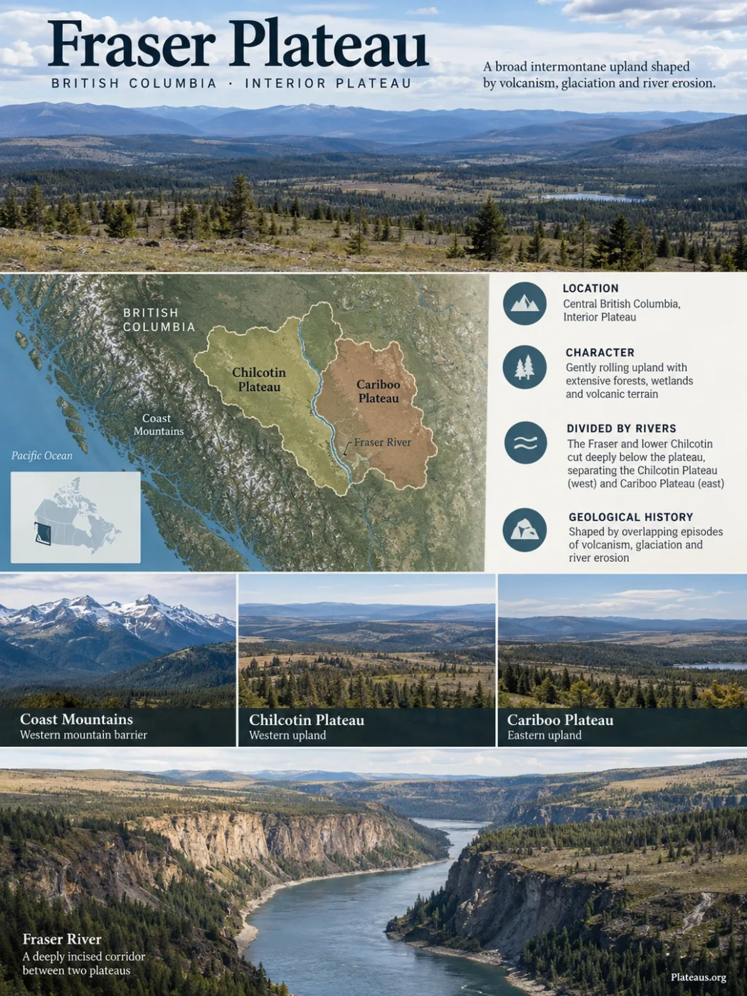
Central British Columbia · Interior Plateau
The Fraser Plateau is a broad intermontane upland in the central interior of British Columbia, shaped by overlapping episodes of volcanism, glaciation and river erosion. Much of its surface is gently rolling, but the Fraser River and lower Chilcotin River cut deeply below that upland, dividing it into the Chilcotin Plateau to the west and the Cariboo Plateau to the east.
Interior Plateau
Volcanic and glaciated upland
The Fraser River Cuts the Plateau Into Two Uplands
The official British Columbia geographical name places the Fraser Plateau east of the Coast Mountains, extending northwest from the Bonaparte River toward the Dean and West Road rivers. Its approximate centre is recorded near 52°N, 123°W, but that coordinate identifies the feature rather than defining a surveyed boundary.
Within that broad region, the Fraser River is much more than a drainage line. The Fraser and lower Chilcotin have cut well below the surrounding upland, creating a deeply dissected corridor between two large plateau surfaces. Provincial physiographic descriptions identify the Chilcotin Plateau on the western side and the Cariboo Plateau on the eastern side.
Mountain barrier along the western side of the plateau region.
The broad western upland, containing extensive forests, wetlands and volcanic terrain.
Deep river valleys cut below the plateau surface and expose rock and glacial sediment.
The eastern plateau surface, grading toward the Quesnel Highland and Fraser Basin terrain.
Boundary Note
The Fraser Plateau is a physiographic region, not an administrative unit with a surveyed perimeter. Its edges can be transitional, especially where plateau surfaces rise toward adjoining mountains and highlands. Geological, ecological and physiographic maps may therefore show different boundaries without necessarily contradicting one another.
Fraser Plateau, Chilcotin Plateau and Chilcotin Group Are Different Things
Several names used in central British Columbia overlap geographically but describe different kinds of features. Keeping them separate is important because a rock unit, an ecological region and a plateau subdivision do not have to share the same boundary.
| Term | What It Describes | Relationship to the Fraser Plateau |
|---|---|---|
| Fraser Plateau | A physiographic plateau region | The larger landform discussed here, within British Columbia’s Interior Plateau. |
| Chilcotin Plateau | A plateau subdivision | The major western part of the Fraser Plateau. |
| Cariboo Plateau | A plateau subdivision | The major eastern plateau surface beyond the deeply incised Fraser corridor. |
| Chilcotin Group | A volcanic rock assemblage | Basaltic lavas cover large parts of the plateau but do not define every part of its underlying geology. |
| Fraser Plateau ecoregion | An ecological mapping unit | Defined using climate, vegetation and ecosystem relationships rather than only physiographic boundaries. |
The distinction is particularly important for the Chilcotin Group. Its lavas occur across a wider volcanic province of south-central British Columbia. They strongly influence the Fraser Plateau’s surface, yet the geographic outline of the plateau cannot simply be traced around every exposure of Chilcotin basalt.
A Broad Upland Surface Sits Above Deep River Valleys
Large undissected parts of the Fraser Plateau are commonly described as flat to gently rolling uplands around 1,200–1,500 metres. Toward parts of the southeast, the regional surface rises toward roughly 1,800 metres. These figures describe broad upland levels rather than a single elevation for the entire plateau.
Local elevations vary much more. River valleys descend far below the upland surface, while isolated hills and volcanic ranges project well above it. Studies of individual southern sectors, for example, describe gently undulating plateau surfaces below the typical 1,200–1,500 metre upland band as well as isolated higher terrain. A single average elevation would therefore hide one of the Fraser Plateau’s defining characteristics: low-relief uplands separated by deeply incised drainage corridors and local mountain masses.
Elevation Is Not a Single Plateau Number
The often-cited 1,200–1,500 metre range refers mainly to extensive upland surfaces. It should not be treated as the minimum and maximum elevation of the whole Fraser Plateau.
The gentle surface also does not mean the plateau is perfectly flat. Glacial ridges, shallow depressions, lake basins, low volcanic relief and stream valleys repeatedly interrupt the upland. Seen at regional scale, however, these forms sit within a broad surface that is markedly less rugged than the Coast Mountains to the west.
Basalt Shapes the Surface but Does Not Form the Entire Foundation
Descriptions of the Fraser Plateau often emphasize volcanic basalt, and with good reason: flat-lying or gently dipping lava flows account for many of its table-like surfaces, scarps and canyon exposures. The underlying geology, however, is much older and more varied.
Modern geological mapping across the Bonaparte Lake–Quesnel River area, which includes a large southeastern sector of the Fraser Plateau, shows an extensive foundation of early Mesozoic rocks belonging mainly to the Quesnel terrane, together with older terranes and intrusive bodies in adjoining areas. The volcanic plateau cover therefore rests on a structurally complex geological basement rather than on one uniform block of basalt.
This distinction becomes visible where erosion removes the younger cover. River valleys, canyon walls, road cuts and isolated bedrock windows can expose rocks that are very different from the basalt seen on nearby plateau rims.
Glacial sediment, soils, wetlands and modern drainage features commonly cover the plateau.
Chilcotin Group basalt forms broad caps and locally thick stacks of lava flows.
Older volcanic, sedimentary, metamorphic and intrusive rocks lie beneath or beside the younger lava cover.
Chilcotin Group Lava Forms a Patchwork Rather Than One Giant Sheet
The Fraser Plateau is sometimes simplified as the product of a single enormous flood-basalt episode. Geological evidence supports a more complicated picture. The Chilcotin Group consists mainly of basaltic lavas erupted repeatedly from dispersed volcanic centres across the British Columbia interior.
Recent geological syntheses place Chilcotin Group eruption ages broadly between about 28 and 1 million years ago. The volcanic rocks form a regionally extensive but discontinuous cover rather than an uninterrupted sheet, and individual basaltic packages can range from only a few metres to roughly 200 metres thick.
Oversimplified Model
- One enormous eruption
- One continuous basalt sheet
- A plateau built entirely from lava
- Uniform volcanic geology from edge to edge
Geological Pattern
- Many eruptive episodes across a long time span
- Numerous dispersed volcanic sources
- Flows that overlap, fill older low areas and form local caps
- Basalt resting on a varied older geological foundation
Some flows spread across broad surfaces, while others followed existing valleys and depressions. Later erosion removed parts of the lava cover, leaving flat-topped remnants and steep rimrock exposures. This helps explain why basalt is prominent in some canyon walls yet absent at the surface only a short distance away.
Where thick sequences are exposed, individual flows can often be distinguished. Southern Fraser Plateau studies have documented basalt stacks more than 100 metres thick in places, with more than ten flows visible in deeply cut sections. These are local exposures, not a uniform thickness for the entire plateau.
Columnar Basalt Marks Many Exposed Lava Edges
Cooling fractures produced the columnar jointing visible in some Fraser Plateau basalt cliffs. These near-vertical fractures can make eroded lava margins look like walls or steps. Provincial geological descriptions also record flat-topped outliers and rimrock scarps where erosion has isolated remnants of formerly broader lava surfaces.
Ice Reworked the Volcanic Surface
The modern plateau cannot be understood from volcanism alone. During the Pleistocene, the Cordilleran Ice Sheet spread across the British Columbia interior. Ice moved over the Fraser Plateau, modified its bedrock surface and left extensive deposits of till, sand and gravel.
Much of the upland is consequently mantled by glacial drift. In many places the basalt or older bedrock is not visible at all. Provincial physiographic descriptions note widespread drift and abundant glacially shaped low-relief features, while modern work on the southern plateau confirms extensive regional till cover over the volcanic bedrock.
Terranes, Sedimentary Rocks and Intrusions Form the Basement
The crust beneath the plateau developed through a much longer geological history than the younger surface lavas.
Basaltic Lava Spreads Across Parts of the Interior
Repeated Chilcotin Group eruptions cover older surfaces and fill some existing depressions and valleys.
Ice Covers and Reshapes the Plateau
Glacial erosion modifies the landscape while till and meltwater sediment bury large areas of bedrock.
Meltwater Cuts Channels Across the Upland
Retreating ice redirects large volumes of meltwater through channels that can be much larger than the streams occupying them today.
Rivers Continue to Incise the Plateau
Drainage systems deepen valleys, expose basalt and older rocks, and separate broad remnants of the upland surface.
Lakes and Wetlands Fit the Glacial Landscape
The same processes that smoothed parts of the plateau also left an irregular surface of shallow depressions, poorly drained hollows and low ridges. Many of those depressions now contain lakes, ponds or wetlands. The result is a landscape where forested uplands and abundant water bodies can occur together even though the regional relief is modest.
River Incision Exposes What the Plateau Surface Hides
From above, much of the Fraser Plateau looks subdued. Along its major rivers, that impression changes quickly. The Fraser River and several tributaries have cut deeply below the regional surface, exposing long sections through glacial sediment, basalt and older bedrock.
Fraser River
The Fraser is the dominant erosional corridor. Its valley separates broad western and eastern uplands and locally cuts hundreds of metres beneath surrounding plateau surfaces. In some southern Fraser Plateau studies, river and tributary incision approaches about 700 metres relative to nearby high ground, although that value describes particular deeply dissected sectors rather than the whole plateau.
Lower Chilcotin River
The lower Chilcotin joins the Fraser within one of the plateau’s most strongly dissected areas. Provincial ecological mapping describes the Fraser and lower Chilcotin valleys as a deep badlands zone that helps separate the Chilcotin Plateau from the Cariboo Plateau.
West Road, Dean and Bonaparte Rivers
Other rivers help define the plateau at regional scale. The West Road River, also called the Blackwater River, is closely associated with the northern transition toward the Nechako Plateau. The Dean River is part of the northwestern boundary description, while the Bonaparte River marks the southeastern end of the official Fraser Plateau place-name description.
Chasm Records a Different Kind of Erosion
Not every deep cut in the plateau was made by a modern river. At Chasm in the southern Fraser Plateau, glacial meltwater excavated a large corridor through basalt. The resulting canyon exposes stacked lava flows and provides one of the clearest examples of how deglaciation could carve sharply into an otherwise low-relief volcanic surface. Geological work in the area also shows that glacial deposits commonly conceal the same basalt away from the canyon walls.
Dry Canyons and Pine-Wetland Uplands Occupy the Same Plateau
The Fraser Plateau lies inland of the Coast Mountains, where Pacific moisture is reduced as air crosses the mountain barrier. The effect is especially clear across the southern plateau, which forms a pronounced interior rain-shadow landscape. The resulting climate is not uniform: elevation, latitude and distance from the Coast Mountains create large ecological differences across the region.
One characteristic ecological zone is the Sub-Boreal Pine–Spruce zone. British Columbia’s current description places much of this zone on the high, gently rolling Fraser Plateau and describes dry lodgepole-pine forests, extensive wetlands and relatively limited urban or agricultural development. Forestry and ranching are widespread land uses within the zone.
Incised Valleys
Drier Slopes and Grasslands
Lower Fraser and Chilcotin valley terrain can be markedly drier than surrounding uplands, with open slopes and grassland vegetation replacing continuous forest in some areas.
Rolling Uplands
Lodgepole-Pine Forest
Dry lodgepole-pine forest is characteristic across extensive parts of the central plateau, particularly west of the Fraser River.
Glacial Depressions
Lakes and Wetlands
Low-relief terrain and glacial deposits create numerous shallow basins where wetlands, ponds and lakes interrupt the forest.
Higher Terrain
Cooler Montane and Subalpine Environments
As the plateau rises toward volcanic ranges and mountain margins, cooler forest belts replace the lower and drier plateau communities.
Ecological Elevations Are Not Plateau Boundaries
The Sub-Boreal Pine–Spruce zone occurs at roughly 850–1,300 metres in its northern part and can reach about 1,500 metres in southern and western areas. Those values describe a biogeoclimatic zone, not the full elevational extent of the Fraser Plateau.
Volcanic Ranges Rise Above the Low-Relief Surface
The plateau’s broad rolling form is interrupted in the west by several prominent volcanic mountain masses. The Rainbow, Ilgachuz and Itcha ranges project well above the surrounding Fraser Plateau and form some of its clearest departures from the normal upland profile. Classic British Columbia physiographic mapping identifies all three as volcanic ranges lying within the plateau region near Anahim Lake.
The Ilgachuz Range, for example, rises to more than 2,400 metres within an otherwise much lower plateau setting. Provincial ecological documentation describes it as an isolated volcanic massif within the Fraser Plateau.
These high areas show why a plateau should not be imagined as a perfectly level table. A regional plateau can contain mountains that rise well above its general surface while still retaining a recognizable broad upland around them.
Large areas retain gently rolling, comparatively low-relief terrain.
Itcha, Ilgachuz and Rainbow volcanic masses rise above that regional surface.
Ice and later erosion reshape both the ranges and the surrounding plateau.
Mountain masses, rolling forested uplands and deep river cuts coexist within one physiographic region.
Landscape Features That Reveal the Fraser Plateau’s Structure
Volcanic Surface
Flat-Topped Basalt Remnants
Resistant lava caps can preserve broad upper surfaces after erosion removes adjacent material.
Canyon Exposure
Stepped and Columnar Basalt Walls
Deep cuts expose individual lava units and cooling joints that remain hidden beneath forest and glacial sediment elsewhere.
Glacial Surface
Rolling Till-Covered Terrain
Much of the apparent plateau surface is glacial sediment rather than bare volcanic bedrock.
Drainage
Deep Valleys Below Gentle Uplands
The sharp difference between broad upper surfaces and deeply incised rivers is one of the plateau’s most recognizable regional patterns.
Low-Relief Depressions
Lakes and Wetlands
Glacially modified depressions interrupt the forested upland and help produce the dense lake-and-wetland pattern seen across parts of the plateau.
Local High Relief
Volcanic Ranges Above the Plateau
Itcha, Ilgachuz and Rainbow demonstrate that substantial mountain relief can exist inside a much broader plateau system.