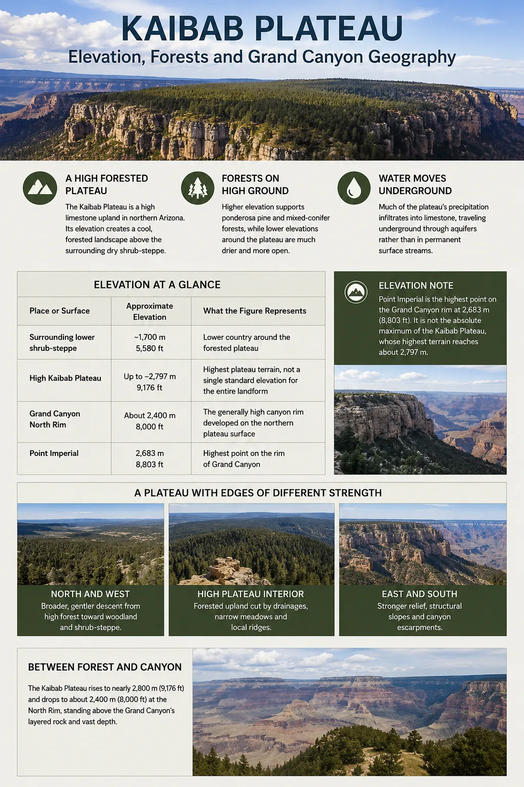
The Kaibab Plateau is a high, forested limestone upland in northern Arizona whose southern edge forms much of the Grand Canyon’s North Rim. Its elevation explains the abrupt change from dry shrub-steppe around its margins to ponderosa pine and mixed-conifer forest on the higher surface, while its geology helps explain both the canyon rim and an unusual water system in which much of the plateau’s precipitation moves underground rather than through permanent surface streams.
A High Plateau That Becomes the North Rim
The Kaibab Plateau is part of the larger Colorado Plateau physiographic region. It lies north of the Colorado River in northern Arizona, extending from the Grand Canyon toward the Arizona–Utah border. Jacob Lake sits near its northern approach, while the plateau rises west of House Rock Valley and Marble Canyon before ending abruptly along the Grand Canyon to the south.
Its shape is commonly described as roughly oval, about 95 km (59 mi) long and 55 km (34 mi) wide. The highest ground reaches approximately 2,797 m (9,176 ft) above sea level, compared with surrounding shrub-steppe country near 1,700 m (5,580 ft). The result is not a low desert tableland but a cool, elevated forest mass standing above much drier terrain.
| Place or Surface | Approximate Elevation | What the Figure Represents |
|---|---|---|
| Surrounding lower shrub-steppe | ~1,700 m / 5,580 ft | Lower country around the forested plateau |
| High Kaibab Plateau | Up to ~2,797 m / 9,176 ft | Highest plateau terrain, not a single standard elevation for the entire landform |
| Grand Canyon North Rim | About 2,400 m / 8,000 ft on average | The generally high canyon rim developed on the northern plateau surface |
| Point Imperial | 2,683 m / 8,803 ft | Highest point on the rim of Grand Canyon |
Point Imperial and the Plateau Maximum Are Different Measurements
Point Imperial is the highest point on the Grand Canyon rim at 2,683 m (8,803 ft). It should not be presented as the absolute maximum elevation of the entire Kaibab Plateau, whose highest terrain reaches roughly 2,797 m.
The plateau also should not be equated with Kaibab National Forest. The national forest is an administrative land unit, while the Kaibab Plateau is a physical landform. Parts of the plateau lie within Kaibab National Forest and parts lie within Grand Canyon National Park.
The Plateau Is Steepest Where Its Geography Matters Most
Kaibab is not a uniformly flat block with identical edges. Its margins have different forms because the plateau has been uplifted, faulted and deeply eroded.
To the south, the land ends in the immense escarpments and side canyons of the Grand Canyon. The eastern margin also descends steeply toward House Rock Valley and the Marble Canyon region. Northward and westward, the transition to lower terrain is generally gentler.
Broader, gentler descent from high forest toward woodland and shrub-steppe
Forested upland cut by drainages, narrow meadows and local ridges
Stronger relief, structural slopes and canyon escarpments
Even the interior is not a perfectly level surface. Moderately sloping drainages cut across the plateau, while meadows, ridges and fire-created openings interrupt otherwise extensive forest. Near the southern edge, tributary canyons such as Bright Angel Canyon dissect the plateau so deeply that the former upland surface survives as separate rims, points and projecting plateau remnants.
Elevation Creates a Forest Island Above the Desert
One of the clearest ways to recognize the Kaibab Plateau is through vegetation. From a distance, its forested surface contrasts sharply with the lower, drier country around it. Ecological research has described it as a forested island separated from other extensive forests by expanses of lower shrub-steppe.
The contrast is mainly an elevation effect. As the land rises, temperatures decrease and precipitation generally increases. Winter snowfall becomes more important, and conditions become suitable for forest communities that cannot dominate the warmer terrain below.
The transition does not occur along perfectly horizontal contour lines. Slope direction, drainage position, soil, past fire and local moisture can push individual tree species above or below their usual elevation range. Even so, the broad sequence is clear.
| Approximate Elevation | Typical Vegetation | Landscape Character |
|---|---|---|
| ~1,700–2,182 m | Pinyon pine and juniper woodland | Drier transition between shrub-steppe and the main plateau forest |
| ~2,075–2,450 m | Ponderosa pine | Extensive, comparatively open pine forest; mixed species may follow cooler drainages |
| ~2,450–2,600 m | Ponderosa pine, Douglas-fir, white fir, blue spruce and aspen | Drier mixed-conifer forest |
| Above ~2,600 m | Spruce, fir, Douglas-fir, quaking aspen and patches of ponderosa pine | Cooler, denser high-elevation mixed-conifer forest |
The overlap between these elevation bands is meaningful. Ponderosa pine can extend higher on warm ridges and south-facing slopes, while spruce, Douglas-fir and aspen can follow cool drainages downward. The forest pattern therefore records both elevation and local topography.
Ponderosa Pine Dominates Much of the Plateau
Large areas of the middle and lower forest zone are characterized by ponderosa pine. On relatively dry sites the forest can be open, with grasses and other ground vegetation between mature trees. Gambel oak occurs in parts of this belt, while cooler pockets support species more typical of mixed-conifer forest.
This ponderosa zone is important geographically because it occupies the broad transition between the dry woodland below and the colder forest near the plateau crest.
Mixed Conifers and Aspen Mark the Highest Country
At high elevations, the forest becomes cooler and generally denser. Douglas-fir, white fir, Engelmann spruce, blue spruce, subalpine fir and quaking aspen can all occur within the high plateau environment.
Aspen often forms conspicuous groves rather than a continuous forest. Narrow meadows also interrupt the tree cover in parts of the plateau, creating a patchwork of conifer forest, aspen and open grassland rather than an unbroken canopy.
Why the North Rim Is Greener Than the South Rim
The Kaibab Plateau helps explain one of the most obvious geographic differences between the two sides of Grand Canyon. The North Rim is generally about 300 m (1,000 ft) higher than the South Rim, which lies mainly on the Coconino Plateau.
North Rim
- Associated mainly with the Kaibab and Kanab plateau highlands
- Average elevation around 2,400 m (8,000 ft)
- Cooler and generally wetter
- Supports high-elevation spruce-fir forest above about 8,200 ft
- Receives heavier winter snowfall
South Rim
- Developed mainly on the Coconino Plateau
- Average elevation around 2,100 m (7,000 ft)
- Warmer and drier overall
- Ponderosa pine is widespread at rim elevations
- High-elevation spruce-fir conditions are much less extensive
This elevation difference affects far more than temperature. It changes snowfall, soil moisture, growing conditions and the distribution of forest communities. The dense northern forests are therefore not simply a scenic contrast with the canyon. They are a direct expression of the Kaibab Plateau’s greater elevation.
A Snowy Plateau With Almost No Permanent Surface Streams
The Kaibab Plateau presents an apparent contradiction. It receives more precipitation than much of the surrounding Grand Canyon region and carries extensive forest, yet no perennial surface streams drain from the plateau.
The explanation lies below ground. Much of the plateau is built from fractured, soluble carbonate rock. Rain and snowmelt can enter joints, faults, sink-like depressions and other openings rather than remaining at the surface. Over time, dissolution has enlarged underground pathways into a karst groundwater system.
High elevation increases the opportunity for precipitation and snowmelt to enter the plateau.
Water infiltrates through joints, faults and soluble carbonate rock instead of forming a dense network of permanent streams.
Subsurface water moves through fractures and cave networks beneath the plateau.
Some groundwater eventually emerges from large springs far below the plateau surface inside the Grand Canyon.
Groundwater movement is strongly influenced by faults and fractures. Some cave systems can transmit flood pulses rapidly, carrying water for many kilometres beneath the plateau before it reaches canyon springs.
Why Forest Does Not Mean Abundant Surface Water
Kaibab’s high elevation creates relatively cool and moist conditions, but its limestone geology allows a large share of that water to infiltrate. A landscape can therefore support dense forest while still lacking permanent rivers and streams on its surface.
The Limestone Cap Beneath the Forest
Much of the plateau surface is associated with the Kaibab Formation, a resistant sequence dominated by marine limestone along with siltstone and related sedimentary rocks. These rocks were deposited about 270 million years ago during the Permian Period, when the region was near a shallow tropical sea rather than thousands of metres above sea level.
The same formation is exposed along both rims of the Grand Canyon, where it forms the canyon’s youngest major sedimentary layer and much of the resistant cap rock near the top of the walls.
Kaibab Plateau Is Not the Same as Kaibab Formation
Kaibab Plateau is the geographic upland. Kaibab Formation is a rock unit exposed across parts of the Colorado Plateau, including the Grand Canyon rims. The rock unit helps form the plateau surface, but the two names describe different things.
The presence of marine limestone at elevations approaching 2,800 m records a much later phase of regional uplift. The sedimentary layers accumulated long before the modern plateau existed, then rose with the broader Colorado Plateau while remaining comparatively flat over large areas.
The Kaibab Uplift and the Plateau’s Eastern Edge
The Kaibab Plateau is also a structural high within the Colorado Plateau. Its bedrock is associated with the Kaibab uplift, where sedimentary strata stand higher than surrounding areas without the intense folding seen in many mountain belts.
One of the clearest structural features lies along the eastern side. The East Kaibab Monocline bends the rock layers downward toward House Rock Valley and forms an important part of the structural transition between the high Kaibab surface and lower terrain to the east.
This distinction matters because Kaibab is not simply a flat surface left behind by erosion. Its present height reflects both regional Colorado Plateau uplift and local structural deformation, while erosion has sharpened its escarpments and cut deeply into its margins.
The broader uplift history is still an active geological question. Colorado Plateau strata rose thousands of feet while remaining unusually intact and nearly horizontal across large areas. The exact processes that produced that pattern cannot be reduced to a single simple uplift event.
Why Does the Colorado River Cut Through the Kaibab High?
The modern topography creates a difficult geological question. The Kaibab Plateau forms one of the highest areas beside the Grand Canyon, yet the Colorado River crosses the structural high rather than simply flowing around it.
The canyon itself is much younger than the rocks exposed in its walls. Much of the modern Grand Canyon developed during roughly the last 5–6 million years, after older drainage systems became connected into a through-flowing Colorado River. The landscape through which that drainage developed, however, did not necessarily look like the landscape visible today.
An Unresolved Part of Grand Canyon Geology
There is no need to assume that the present-day Kaibab Plateau stood as the same high obstacle when the Colorado River established its course. The structural high may have had less topographic relief, or younger Mesozoic rocks may still have covered parts of it. Several models for drainage integration and canyon development remain under study.
Once a river occupies a course across rising or eroding terrain, continued downcutting can preserve that route even as relief increases around it. At Kaibab, however, the early drainage history is complicated enough that a simple statement such as “the river was there first” gives more certainty than the evidence supports.
This unresolved relationship is one reason the plateau is central to Grand Canyon geology. The river does more than border Kaibab. It cuts through the Kaibab structural high, exposing the rock sequence and separating high plateau surfaces on opposite sides of the canyon.
How Kaibab Becomes the Grand Canyon’s North Rim
The North Rim is best understood as the deeply eroded southern margin of a much larger highland. Travel north from the canyon and the dramatic rim gradually gives way to the forested interior of the Kaibab Plateau. Move southward, and tributary valleys begin cutting that surface apart before the land drops into the main canyon.
Point Imperial shows this relationship particularly well. At 2,683 m (8,803 ft), it is the highest point on the Grand Canyon rim. Nearby, the landscape includes high forest, dissected plateau surfaces and the transition between Marble Canyon and the wider Grand Canyon.
Farther south and west, erosion has produced projecting uplands and smaller named surfaces such as the Walhalla Plateau. These are not separate from the larger geographic story. They are parts of a plateau margin that has been progressively cut into by tributaries of the Colorado River.
High forested plateau with meadows and shallow to moderate drainages
Tributary canyons separate ridges, points and smaller plateau surfaces
High southern edge of the plateau overlooking the Grand Canyon
Layered cliffs descend toward the deeply incised Colorado River
The diagram is conceptual rather than a scale cross-section. The essential relationship is that the famous rim is not an isolated ridge beside the canyon. It is the exposed edge of an elevated plateau landscape.
The Dragon Bravo Fire Reshaped Part of the Plateau Forest
The Kaibab forest is also a fire-shaped landscape. That became especially visible after the Dragon Bravo Fire, which started from lightning on July 4, 2025, west of the North Rim developed area. The fire eventually burned 149,399 acres across the Kaibab Plateau, including 71,129 acres on lands managed by Grand Canyon National Park.
The burn did not affect every part of the forest equally. Post-fire field assessment on park-managed land found a predominantly low- to moderate-severity mosaic. About 68–75% of the assessed area was unburned or had low soil burn severity, roughly 24–26% was moderate, and only about 1–2% was classified as high severity.
This distinction is important when interpreting the post-fire landscape. A mapped fire perimeter does not mean that every tree, soil surface or habitat inside it was severely burned. In low-severity areas, much organic material, root structure and soil structure remained intact. Moderate patches experienced greater vegetation change, while localized high-severity areas have higher potential for runoff, erosion and longer-term vegetation change.
Post-Fire Geography
Burn severity can alter more than vegetation. Loss of canopy and ground cover can increase runoff on steep slopes, while burned canyon margins can become more susceptible to erosion, debris flows, rockfall and falling trees during later storms. These effects connect forest disturbance directly with the geomorphology of the North Rim.
The North Rim reopened for the 2026 season, but recovery areas remain part of the present plateau landscape. The result is a new forest mosaic in which intact stands, lightly burned woodland, recovering meadows and more heavily altered patches occur across the same high surface. Over time, regeneration, subsequent fires, erosion and changing forest structure will continue to modify that pattern.