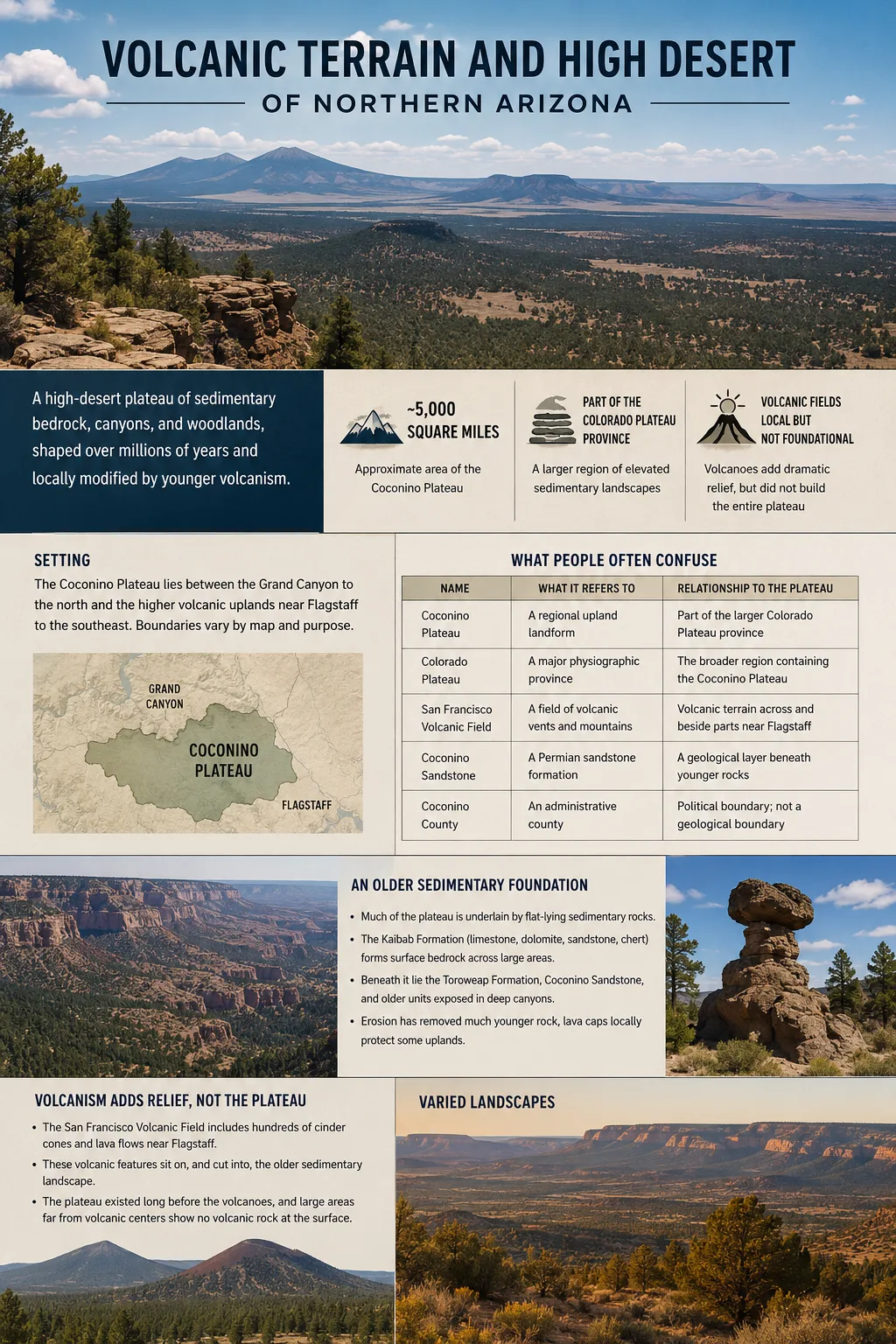
The Coconino Plateau is a broad high-desert upland in northern Arizona, south of the Grand Canyon and within the larger Colorado Plateau province. Its landscape combines an older sedimentary platform with canyon incision, dry woodland and grassland, and younger volcanic terrain toward the Flagstaff region. The volcanoes are visually prominent, but they did not create the entire plateau.
Where the Coconino Plateau Sits in Northern Arizona
The Coconino Plateau occupies part of north-central Arizona between the deeply cut Grand Canyon country to the north and higher volcanic uplands around Flagstaff to the southeast. It belongs to the much larger Colorado Plateau, a regional province characterized by elevated sedimentary rocks, broad uplands, mesas, cliffs, canyons, and locally superimposed volcanic landforms.
A commonly cited geological estimate places the Coconino Plateau itself at roughly 5,000 square miles. Larger figures sometimes associated with the plateau can describe hydrogeologic study areas that extend beyond the physical plateau into neighboring drainage and groundwater-discharge areas.
Boundary Note
The Coconino Plateau does not have a simple administrative boundary. Geological and physiographic maps may separate the plateau from the San Francisco Volcanic Field, Mount Floyd Volcanic Field, Grand Canyon, and neighboring basins. Its mapped outline can therefore vary with the purpose and scale of the map.
This distinction matters near Flagstaff. A map may show volcanic terrain beside or partly overlapping the broader upland landscape, while a regional description may treat the same area as part of the wider Coconino Plateau setting. Neither approach means the plateau and the volcanic field are the same landform.
| Name | What It Refers To | Relationship to the Plateau |
|---|---|---|
| Coconino Plateau | A regional upland landform | Part of the larger Colorado Plateau province |
| Colorado Plateau | A major physiographic province of the southwestern United States | The much larger regional system containing the Coconino Plateau |
| San Francisco Volcanic Field | A field of hundreds of volcanic vents and mountains | Creates volcanic relief across and beside parts of the plateau landscape near Flagstaff |
| Coconino Sandstone | A Permian sandstone rock formation | A geological layer beneath younger rocks in the regional stratigraphic sequence |
| Coconino County | An administrative county in Arizona | Its political boundary should not be used as the plateau boundary |
An Older Sedimentary Plateau Beneath the Volcanic Landscape
The broad foundation of the Coconino Plateau is not a pile of volcanic lava. Much of the plateau is developed on comparatively flat-lying sedimentary rocks that belong to the long geological history of the Colorado Plateau.
The Kaibab Formation, an Early Permian unit containing limestone, dolomite, sandstone, and chert, forms surface bedrock across large parts of the plateau. In some areas it is covered by younger sediment, erosional remnants of younger formations, or volcanic deposits.
Below the Kaibab Formation lies a thicker sequence that includes the Toroweap Formation, Coconino Sandstone, and older sedimentary units. Deep canyon erosion exposes parts of this stacked rock sequence that remain hidden beneath the broad plateau surface.
Coconino Plateau Is Not Coconino Sandstone
The similar names describe different things. Coconino Plateau is a landform region. Coconino Sandstone is one rock formation within the regional geological sequence and commonly lies below the Kaibab and Toroweap formations.
The plateau surface has also lost large amounts of younger rock through erosion. Remnants of younger sedimentary units survive locally as low hills and mesas, while resistant lava caps protect some isolated uplands from erosion. This helps explain why apparently simple plateau country contains scattered mesas, volcanic hills, broad valleys, and abrupt changes in local relief.
Volcanism Was Added to the Plateau Rather Than Building It
The strongest volcanic influence occurs toward the San Francisco Volcanic Field around Flagstaff. The field covers about 1,800 square miles and has produced more than 600 volcanoes during roughly six million years of activity.
These eruptions altered an already existing Colorado Plateau surface. Basalt spread across older rock, cinder cones rose above broad uplands, lava filled low areas, and larger volcanic centers produced mountains far higher than the surrounding plateau.
This is the most useful way to interpret the phrase volcanic terrain in relation to the Coconino Plateau: the volcanic rocks are a younger layer of landscape development superimposed on older sedimentary terrain.
Cinder Cones and Lava Flows
Many of the smaller hills between Flagstaff and the Grand Canyon are volcanic features rather than remnants carved solely from sedimentary strata. Basaltic eruptions built numerous cinder cones from fragments of lava thrown from vents, while flowing lava spread across surrounding surfaces.
The result is a different kind of terrain from the pale limestone uplands farther across the plateau. Volcanic areas can contain dark lava surfaces, steep-sided cones, crater rims, resistant lava-capped hills, and irregular drainage patterns within only a short distance of broad sedimentary plains.
San Francisco Mountain Rises Far Above the Plateau Surface
The largest volcanic feature is San Francisco Mountain, the eroded stratovolcano that contains Humphreys Peak at 12,633 feet (3,850 meters), the highest point in Arizona.
That elevation should not be treated as the elevation of the Coconino Plateau itself. It demonstrates how strongly volcanic construction can increase local relief above an existing plateau surface. A landscape can therefore remain part of plateau country at a regional scale while containing individual mountains that rise thousands of feet higher.
Sedimentary Rocks Accumulate
Marine and continental sediments form the stacked Paleozoic and younger rock units that underlie the region.
Uplift and Erosion Reshape the Surface
Elevation of the Colorado Plateau region allows drainage systems to remove younger rocks and cut progressively deeper into the sedimentary sequence.
Volcanism Adds New Relief
Hundreds of volcanic vents develop in the San Francisco Volcanic Field, adding lava flows, cones, domes, and larger volcanic mountains to the older landscape.
Sunset Crater Erupts
One of the youngest episodes creates a cinder cone, extensive tephra deposits, and the Bonito and Kana’a lava flows.
Sunset Crater Shows How Recent the Volcanic Terrain Can Be
Sunset Crater provides a clear example of young volcanic terrain close to the Coconino Plateau. Modern tree-ring and geochemical evidence places its eruption in 1085 CE, making it the youngest eruption recognized in the San Francisco Volcanic Field.
The eruption began along a fissure several miles long. Lava fountains produced cinders and larger fragments that accumulated around the main vent, building the cone. Lava also escaped from the volcanic system and formed the Bonito and Kana’a flows.
The contrast in age is important. Sedimentary rocks exposed across the plateau are hundreds of millions of years old, while some volcanic surfaces in the same regional landscape are only about a thousand years old.
What “Volcanically Active” Means Here
The San Francisco Volcanic Field is not an erupting volcano in the everyday sense, but its young geological history means future eruptions are considered possible. The U.S. volcanic threat assessment places the field in the Moderate Threat Potential category. That ranking is used for hazard planning and does not mean an eruption is imminent.
Why the Coconino Plateau Is a High Desert Rather Than a Low Desert
The Coconino Plateau belongs to an arid to semiarid part of the American Southwest, but elevation changes how that dryness appears on the ground. The landscape is considerably cooler than Arizona’s low desert basins, and higher areas receive more precipitation and winter snow.
Rainfall also has a strong seasonal pattern. Summer monsoon storms can produce short periods of intense runoff, while winter frontal systems provide rain or snow. Annual precipitation varies markedly with elevation, exposure, and proximity to higher terrain, so a single rainfall figure does not describe the entire plateau well.
The term high desert therefore should not be interpreted as a continuous treeless or sandy desert. Much of the plateau supports woodland, grassland, shrubland, or forest.
Open grassland, drought-tolerant shrubs, pinyon, and juniper become prominent where moisture is limited.
Ponderosa pine becomes widespread where cooler temperatures and greater precipitation support forest.
Mixed conifer, fir, spruce, and other high-elevation vegetation appear well above the typical high-desert surface.
These vegetation shifts often make elevation visible even without a topographic map. Open pinyon-juniper country can give way to ponderosa forest, while the San Francisco Peaks support much cooler high-mountain environments that would be impossible on Arizona’s lower desert floors.
A Dry Surface Can Hide a Deep Groundwater System
One of the less obvious characteristics of the Coconino Plateau is the contrast between scarce permanent surface water and extensive groundwater beneath the upland.
Much of the landscape contains broad valleys, washes, and internal drainage areas rather than large networks of continuously flowing streams. Storm runoff can temporarily fill channels, but water is lost through evaporation, plant use, infiltration, or movement into deeper drainage systems.
Fractures, faults, permeable sedimentary layers, and local volcanic rocks influence how water moves below ground. Recharge entering at higher elevations may travel through regional aquifers before emerging far from where it originally entered the subsurface.
The C Aquifer
The C aquifer is the shallower of the two major regional groundwater systems commonly described for the plateau and adjacent areas. It occurs mainly beneath eastern and southern parts of the broader hydrogeologic region.
Where saturated, water levels can lie several hundred feet below the surface and in some places more than 1,500 feet deep. Parts of the western plateau lack a continuously saturated C aquifer and instead contain smaller perched groundwater zones.
The Redwall-Muav Aquifer
Below it lies the much deeper Redwall-Muav aquifer. In studied parts of the region, this system can occur more than 3,000 feet below the land surface. Faults and fractures allow partial hydraulic connection between the C aquifer and the deeper Redwall-Muav system in some areas.
| Aquifer | General Position | Reported Depth Pattern | Important Characteristic |
|---|---|---|---|
| C aquifer | Upper regional system, mainly eastern and southern areas | Water can be a few hundred feet to more than 1,500 feet below land surface | Generally behaves as a water-table aquifer where present and saturated |
| Redwall-Muav aquifer | Deeper system beneath the broader study region | More than 3,000 feet below land surface in parts of the area | Usually confined and affected by faults, fractures, recharge, and canyon discharge zones |
Hydrogeology Area Versus Plateau Area
The widely cited 10,300-square-mile figure describes a hydrogeologic study area that includes the Coconino Plateau plus neighboring areas connected to its groundwater system. It should not be presented as the physical area of the plateau itself, which has been described separately as roughly 5,000 square miles.
Canyon Erosion Exposes What the Plateau Surface Hides
A plateau is a broad elevated surface, not a requirement that every part of the land remain flat. The Coconino Plateau becomes increasingly dissected where drainage systems have cut downward through its sedimentary rocks.
Near the Grand Canyon, erosion exposes thousands of feet of rock that remain beneath the upland surface farther south. Tributary canyons extend back into the plateau, progressively replacing broad upland terrain with steep walls, narrow drainage corridors, and isolated remnants of the former surface.
Cataract Canyon and the Havasu drainage illustrate this transition particularly well. Water follows fractures, channels, and structural weaknesses while erosion cuts through the stacked sedimentary sequence. The resulting relief belongs to the same regional landform system even though the canyon floor may sit far below the surrounding plateau.
Differences in rock resistance strengthen the effect. Hard limestone or sandstone beds can form ledges and cliffs, while weaker layers retreat more quickly and form slopes. Where resistant volcanic rocks cap older sedimentary units, they can protect local mesas or hills from erosion and preserve surfaces that would otherwise have been removed.
Why the Landscape Changes So Sharply Around Flagstaff
The Flagstaff area lies near an important transition between broad plateau surfaces and the dense concentration of volcanic landforms in the San Francisco Volcanic Field. Moving across this terrain can therefore produce rapid changes in rock type, elevation, vegetation, and surface shape.
One area may consist of pale, gently rolling sedimentary upland with open grassland or pinyon-juniper woodland. Nearby terrain may be covered by basalt, interrupted by a cinder cone, or dominated by ponderosa forest. Farther upward, San Francisco Mountain rises into a much colder high-elevation environment.
Sedimentary Plateau Terrain
- Broad upland surfaces and low-relief valleys
- Kaibab Formation exposed across large areas
- Layered rock visible where canyons cut downward
- Mesas and cliffs shaped mainly by differential erosion
Volcanic Terrain
- Cinder cones and isolated volcanic hills
- Basalt and other volcanic rocks covering older surfaces
- Lava flows producing rough, resistant ground
- Large volcanic mountains adding strong local relief
Farther south, the wider Colorado Plateau eventually breaks toward lower central Arizona along the Mogollon Rim. The rim is an important part of the regional topographic setting, but it should not be treated as a universally precise southern boundary of the Coconino Plateau. Physiographic, geological, and hydrogeologic maps divide this part of Arizona according to different criteria.