INTERACTIVE CONTEXT MAP
Where is Colorado Plateau?
The selected plateau and nearby mapped locations are shown. Open the full world atlas to explore every region.
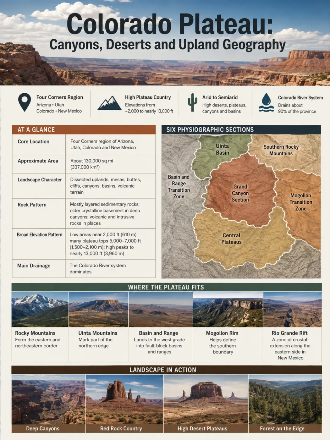
Four Corners Physiographic Province
The Colorado Plateau is a high, deeply dissected region where broad uplands, desert basins, layered cliffs, volcanic mountains and some of North America’s deepest canyons occupy the same raised block of crust.
About 130,000 sq mi
Mostly arid to semiarid
Colorado River drainage dominates
The Colorado Plateau is not one flat tabletop. It is a large physiographic province centered on the Four Corners region of the southwestern United States, made up of plateaus, mesas, basins, escarpments, canyons and isolated mountain masses. Much of its identity comes from an unusual combination: the region rose to high elevation while many of its sedimentary rock layers stayed comparatively flat, and rivers then cut deeply into that raised surface.
That combination explains why the same region can hold dry canyon floors, red-rock benches, pinyon-juniper uplands, forested plateau rims and mountains that approach 13,000 feet (about 3,960 m). Elevation, rock resistance and drainage matter as much as dryness when reading the landscape.
| Geographic Measure | Colorado Plateau Profile |
|---|---|
| Core location | Four Corners region of Arizona, Utah, Colorado and New Mexico |
| Approximate area | Commonly mapped at about 130,000 sq mi (337,000 km²); totals vary with the boundary definition used |
| Broad elevation pattern | Low areas begin near 2,000 ft (610 m); many plateau tops stand around 5,000–7,000 ft (1,500–2,100 m); isolated mountain areas rise to nearly 13,000 ft (3,960 m) |
| Landscape character | Dissected uplands, high desert, mesas, buttes, cliffs, canyons, structural basins and volcanic terrain |
| Main drainage | The Colorado River system drains roughly nine-tenths of the province |
| Rock pattern | Mostly layered sedimentary rocks, with older crystalline basement exposed in deep canyons and volcanic or intrusive rocks in several areas |
Data Note
Published area and elevation summaries are not identical because the Colorado Plateau can be outlined as a strict physiographic province or as a broader geographic region. Approximate figures are more useful than treating one boundary as universally fixed.
Where the Plateau Sits in the American Southwest
The Colorado Plateau lies between several very different landform provinces. The Rocky Mountains border much of its eastern and northeastern side, while the Uinta Mountains mark part of the northern margin. To the west, the terrain grades toward the fault-block basins and ranges of the Basin and Range Province. The Mogollon Rim helps define the southern edge, and the Rio Grande Rift forms a contrasting zone of crustal extension along the eastern side in New Mexico.
Map Note
The map is useful for orientation around the Four Corners, but a general Google Maps label should not be read as the exact scientific boundary of the physiographic province. The natural boundary follows changes in geology and topography rather than state lines.
One Plateau, Six Distinct Physiographic Sections
The name Colorado Plateau hides a large amount of internal variation. A widely used physiographic division separates the province into six sections. They are parts of one regional plateau system, not six unrelated plateaus.
| Section | Geographic Character | Typical Landscape Expression |
|---|---|---|
| Uinta Basin | A broad structural basin and adjoining uplands in the north | Basins, escarpments, river valleys and widespread mudstone and sandstone exposures |
| High Plateaus | High, fault-separated plateau country along the western side | Forested uplands, high cliffs, volcanic rocks and strong elevation contrasts |
| Canyon Lands | Intensely dissected central and southeastern terrain | Deep canyons, mesas, benches, monoclines and isolated laccolithic mountains |
| Navajo | Broad, scarped plateaus that are generally less dissected than the Canyon Lands | Tablelands, cuestas, mesas, broad valleys and sandstone-capped surfaces |
| Grand Canyon | A high structural part of the province cut by major canyon systems | High rims, deep incision, faulted plateau blocks and volcanic terrain |
| Datil | Southeastern plateau country with a strong volcanic component | Lava-covered uplands, volcanic fields, mesas and transition terrain toward the Rio Grande Rift |
This six-part pattern helps explain why descriptions of the Colorado Plateau sometimes seem contradictory. A landscape dominated by deep sandstone canyons in southeastern Utah can belong to the same province as volcanic uplands in New Mexico or a forested high plateau in southern Utah.
Why the Rock Layers Stay So Visible
Much of the Colorado Plateau is built from sedimentary layers deposited in very different environments over hundreds of millions of years. Shallow seas left limestone and marine mud. Rivers and floodplains left sand, silt and clay. Large dune fields produced thick sandstone. Later seas again covered parts of the region.
These layers were eventually raised far above the elevations at which many of them formed. The unusual part is how much of the province retained its broad layered structure during uplift. The neighboring Rocky Mountains underwent far stronger folding, faulting and mountain-scale deformation. Across much of the Colorado Plateau, the strata instead remained horizontal or gently tilted.
They are not perfectly flat. The province contains monoclines, broad upwarps and downwarps, normal faults, volcanic centers and intrusive mountain masses. The Waterpocket Fold in Utah is a clear example: rock layers bend across a long monocline rather than remaining level.
Hard Layers Make Cliffs; Weak Layers Make Slopes
Rock type has a direct effect on the shape of the land. Resistant sandstone and limestone can hold steep cliff faces or cap benches. Softer shale and mudstone tend to weather back into gentler slopes, badlands or recessed bands. Where hard and soft layers alternate, canyon walls often develop a stepped profile.
This process is called differential erosion. It is one reason a single canyon wall can contain vertical cliffs, broad ledges and loose slopes stacked above one another. Fractures, bed thickness and cementation also change how quickly a layer breaks down.
Uplift Created Height; Rivers Converted Height Into Relief
The present landscape developed through several linked stages rather than one event. Sedimentary deposition created the layered rock record. Regional uplift raised large areas of that rock. Drainage networks gained the gradient needed to cut downward, and erosion widened the resulting valleys and canyons.
Layered Rocks Accumulated
Marine, river, floodplain, lake and desert environments deposited the sedimentary units that now form many cliffs and plateau surfaces.
The Region Rose
Large-scale tectonic events, especially during and after the Laramide mountain-building interval, raised the plateau region while leaving much of its layered structure comparatively intact.
River Gradients Steepened
Higher land gave streams more potential energy as they moved toward lower base levels outside the plateau.
Rivers Cut Downward
The Colorado River and its tributaries incised through the raised rock sequence, turning broad uplands into canyon country.
Weathering Widened the Canyons
Tributaries, flash floods, frost action, rockfall and slope retreat removed material from canyon walls and left mesas, buttes and benches between drainage lines.
Much of the plateau’s Laramide uplift is associated with tectonic events roughly 70–40 million years ago, but the history did not stop there. Later uplift, erosion and mantle processes are still being studied. The modern through-flowing Colorado River is far younger than the rocks it cuts; its lower system and Grand Canyon incision developed mainly within the last several million years.
Geology Note
The broad sequence of deposition, uplift, drainage development and incision is well established. The exact timing and mechanism of every phase of Colorado Plateau uplift, and the details of how the upper and lower Colorado River systems became connected, remain active research questions. New field dating and river-sediment studies continue to refine that history.
Why Canyons Dominate So Much of the Plateau
The Colorado Plateau is high enough to create strong river gradients, dry enough to leave large areas of bedrock exposed, and layered enough for erosion to produce steep contrasts between resistant and weak rock. Those conditions favor deep incision and cliff development.
The Colorado River is the main drainage spine. Roughly nine-tenths of the physiographic province drains through the Colorado system, although some marginal areas drain elsewhere. Several major tributaries divide the plateau into distinct canyon and basin landscapes.
2026 Colorado River Operations Update
August 21, 2026: The U.S. Department of the Interior issued the 2027–2028 Colorado River Operating Guidelines and the Record of Decision for post-2026 operations, setting a 10-year decision period for Lake Powell and Lake Mead operations. The department reported that combined storage in the two reservoirs had fallen to a level not seen since before Lake Powell began filling after Glen Canyon Dam closed its gates in 1963, with both reservoirs reaching record lows in recent weeks. For calendar year 2027, Lower Basin deliveries are scheduled to be reduced by 1.25 million acre-feet.
This is not a change in the Colorado Plateau’s geologic or geomorphic setting. It records the current water-management and drought conditions of the Colorado River system that forms the plateau’s main drainage spine.
The Green and Colorado Rivers Divide Canyon Country
The Green River approaches the plateau from the north and joins the Colorado River in southeastern Utah. Around their confluence, Canyonlands contains one of the clearest examples of a plateau surface broken into mesas, canyon walls, narrow divides and entrenched river corridors.
The two rivers do more than occupy existing low ground. Over long periods, downcutting by the main channels lowers local base levels for smaller tributaries. Side streams then incise toward them, extending the canyon network into the surrounding uplands.
The San Juan Shows How Meanders Can Become Entrenched
The San Juan River drains part of the eastern and southeastern plateau before joining the Colorado system. In places, its looping channel pattern is cut deeply into bedrock. These entrenched meanders show that a river can preserve a winding course while incision lowers the channel far below the surrounding upland surface.
The Little Colorado Cuts Across the Southern Plateau
The Little Colorado River drains a large part of northeastern Arizona and enters the Colorado River inside Grand Canyon. Its basin includes broad open country as well as deeply cut tributary systems, showing that not every part of a dissected plateau has the same canyon density.
Small Drainages Do Much of the Widening
Large rivers explain the deepest trunk canyons, but tributaries, washes and gullies do much of the work that expands canyon networks sideways. Short, intense rainstorms can move sediment rapidly through normally dry channels. Freeze-thaw action, rockfall and debris flows also loosen material from canyon walls.
The Grand Canyon Is Cut Into the Colorado Plateau
Common Mix-Up
Grand Canyon is not the Colorado Plateau. It is a vast erosional landform cut into part of the plateau. The plateau is the much larger regional upland system surrounding and extending far beyond the canyon.
Grand Canyon makes the relationship between plateau surface and river incision easy to see. High rims preserve parts of the elevated surface while the Colorado River occupies a much lower corridor. The canyon walls expose a vertical cross-section through sedimentary layers and, in the deepest inner gorge, much older crystalline rocks.
The canyon is also much younger than most of the rock exposed in its walls. The modern Colorado River began cutting the main canyon on a million-year time scale, while many of the rock units it crosses are hundreds of millions of years old. Uplift created the elevation difference that made deep incision possible; river erosion and slope retreat created the canyon form.
Not Every Canyon-Like Landscape Formed the Same Way
The plateau contains several landforms that can look similar from a distance but record different combinations of structure, rock type and erosion.
Canyonlands: Dense River Dissection
In Canyonlands, the Green and Colorado rivers and their tributaries have cut a closely spaced network of canyons through gently tilted sedimentary rocks. Resistant layers preserve mesas and benches between drainages, while weaker beds retreat into slopes.
Waterpocket Fold: Structure Before Erosion
At Capitol Reef, the dominant feature is a long monocline. The rock layers were bent before erosion exposed the structure. Streams then cut gorges across or along the folded strata, so the modern landform reflects both tectonic deformation and erosion.
Bryce Canyon: Amphitheaters Rather Than a River Canyon
Bryce Canyon sits on the edge of the Paunsaugunt Plateau, but its famous scenery is not a single canyon carved by a large river. It is a group of eroded amphitheaters. Repeated freezing and thawing, rainwater dissolution and headward erosion help break the plateau edge into walls, windows and hoodoos.
Why a High Plateau Can Still Be Desert Country
High elevation does not automatically mean a wet landscape. Much of the Colorado Plateau lies in the dry interior of western North America and receives limited moisture. Large areas are therefore arid or semiarid even though they stand well above sea level.
Dryness helps make the geology easy to see. Sparse vegetation leaves broad rock surfaces, cliffs and badlands exposed. Mechanical weathering can act directly on bare bedrock, while short-lived streams can carry large sediment loads after storms.
The term high desert is useful because it separates much of this plateau country from lower and hotter deserts farther south and west. Winter freezing, snowfall and large day-to-night temperature changes are normal across many high parts of the province.
Elevation Stacks Several Landscapes Above One Another
The ecological pattern changes rapidly with height. Lower basins and canyon country commonly support desert shrublands, grasslands and open dry vegetation. Middle elevations often support pinyon-juniper woodland. Higher plateaus can carry ponderosa pine, Douglas fir, lodgepole pine, aspen and other montane vegetation.
These are broad zones rather than fixed elevation bands. Latitude, slope direction, soil, local precipitation and exposure can shift a vegetation boundary up or down. The result is a plateau where dry rock country and cool forest can occur within a relatively short horizontal distance.
The Grand Staircase Shows the Plateau as Giant Rock Steps
Along the western Colorado Plateau, erosion has exposed a regional sequence of cliff-forming strata known as the Grand Staircase. Its major cliff groups are traditionally named the Chocolate, Vermilion, White, Gray and Pink Cliffs.
The staircase is not a constructed sequence of five identical terraces. It is a large-scale expression of tilted and uplifted sedimentary layers eroded at different rates. Resistant units form long escarpments, while weaker units retreat into slopes and benches. Moving northward from the Grand Canyon region toward the high plateaus around Bryce Canyon crosses progressively higher steps in this rock-and-relief sequence.
This is one of the clearest places to see how stratigraphy becomes topography: the order and resistance of rock layers help determine where cliffs stand and where broad surfaces develop.
Mesas, Buttes, Benches and Escarpments Are Parts of One Erosional System
The plateau’s familiar flat-topped landforms are often remnants of larger surfaces. As streams cut into an upland and canyon walls retreat, broad pieces of the former surface become isolated.
A mesa is a flat-topped erosional remnant that is smaller than the regional plateau around it. Continued slope retreat can reduce a mesa to a narrower butte. A bench is a step-like surface commonly held up by a resistant rock layer within a slope or canyon wall. An escarpment is a long, steep slope or cliff separating surfaces of different elevation.
These labels describe shape and scale, but the landforms are linked. Canyon incision separates pieces of upland; differential erosion controls their profiles; slope retreat gradually reduces the size of the remaining flat-topped surfaces.
Volcanic and Intrusive Mountains Break the Sedimentary Pattern
Red and tan sedimentary rock dominates many views, but the Colorado Plateau also contains volcanic fields and igneous mountain masses. This is another reason it should not be treated as one uniform desert tableland.
San Francisco Volcanic Field
Northern Arizona contains a broad volcanic field with hundreds of vents and cinder cones. The San Francisco Peaks rise well above the surrounding plateau and help create one of the province’s strongest local elevation contrasts. Nearby volcanic rocks also record episodes when lava entered or approached canyon systems.
Hopi Buttes and the Datil Volcanic Terrain
The Hopi Buttes area adds volcanic landforms to the Navajo-region landscape, while the southeastern part of the province contains much more extensive volcanic terrain. In the Datil region, lava flows, volcanic deposits and volcanic uplands make the landscape look very different from the canyon-dominated central plateau.
Laccolithic Mountains in Canyon Country
Ranges such as the Henry and La Sal mountains rise as isolated highlands within or beside sedimentary canyon country. They are tied to magma that intruded into the crust and pushed overlying rock upward. Erosion later exposed the resistant igneous cores and surrounding deformed strata. These mountains are not simply higher pieces of a flat plateau surface.
Rock Strength Helps Decide Where Cliffs and Knickpoints Persist
Water availability and river slope are only part of the erosion story. Rock strength controls how easily a channel cuts downward and how long a cliff, ledge or steep reach can survive. Field measurements across the Colorado Plateau have reinforced the close link between mechanical rock strength and river form.
A strong sandstone bed may hold a waterfall, rapid, narrow gorge or cliff line longer than a weak shale bed. Once a river reaches weaker material, incision can speed up. Fractures can reverse that pattern locally by giving water access to otherwise resistant rock.
The landscape therefore reflects several controls working together: channel gradient, water and sediment discharge, fracture density, layer thickness and the resistance of each rock unit. This helps explain why canyon depth and wall shape can change sharply along the same river.
The Plateau’s Boundaries Are Visible in the Shape of the Land
The Colorado Plateau meets neighboring provinces through changes that can be read in topography. To the west, the broad, layered uplands give way to the repeated fault-block ranges and basins of the Basin and Range. Along the east, the province meets the much more strongly deformed Rocky Mountains and the extensional corridor of the Rio Grande Rift.
The southern margin is often associated with the Mogollon Rim, a long escarpment that separates higher plateau country from lower terrain to the south. The northern and northeastern margins meet the Uinta and Rocky Mountain systems. These boundaries are geological transitions, so they do not follow the simple geometry of state borders.
Floods, Rockfalls and Sediment Keep the Landscape Active
The Colorado Plateau is an old geologic region, but its present landforms are still changing. Flash floods can move sand, gravel and boulders through narrow drainages. Rockfalls remove blocks from steep canyon walls. Debris flows can deliver large volumes of coarse sediment to main river channels in a single event.
In Grand Canyon, river flow and sediment movement are now partly shaped by upstream dams, especially Glen Canyon Dam. Regulated flows differ from the large seasonal floods that once moved through the canyon more freely, which changes when and where sand is stored, removed and redeposited along the river corridor.
On plateau rims and high uplands, frost cracking, runoff and slope failure continue to push escarpments backward. On desert surfaces, weathering and episodic flow enlarge washes and gullies. Canyon cutting, mesa reduction and cliff retreat are therefore ongoing geomorphic processes rather than features limited to the distant geologic past.