Plateau Profile
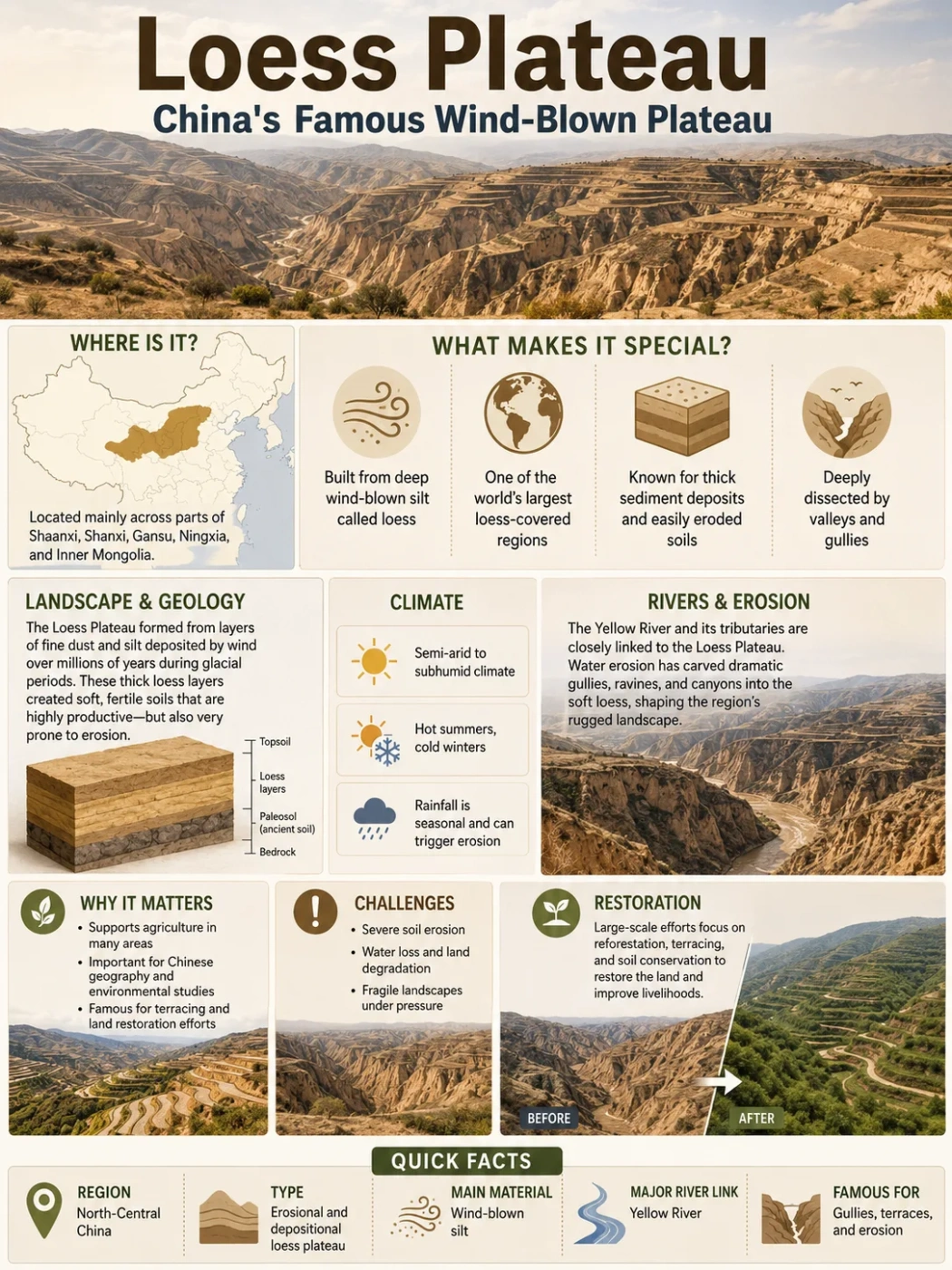
The Loess Plateau is a high, deeply cut landform in north-central China, built from fine wind-blown silt and shaped by the Yellow River system. It is famous because its soft yellow soil records past dust movement, supports long-settled farming landscapes, and shows how wind, water, elevation, and people can reshape one plateau over time.
The Loess Plateau is not a flat slab of land in the simple textbook sense. It is a broad plateau region where thick layers of loess have been lifted, settled, cut by rivers, and carved into gullies, ridges, terraces, and steep valley walls.
Its landscape explains why some plateaus are best understood not only by elevation, but by material. Here, the defining material is loess: fine, yellowish, wind-deposited silt that can stand in steep faces yet erodes quickly when water cuts into it.
| Feature | Loess Plateau Profile |
|---|---|
| Name | Loess Plateau, also known in Chinese as Huangtu Gaoyuan |
| Location | North-central China, mainly around the middle reaches of the Yellow River |
| Main Regions | Large parts of Shaanxi and Shanxi, with areas in eastern Gansu and northern Henan; broader regional definitions may also touch Ningxia, Inner Mongolia, and Qinghai |
| Approximate Elevation | Often described around 1,200 m on average, with many plateau surfaces roughly between 900 m and 2,100 m |
| Approximate Area | About 400,000 km² in narrower geographic descriptions; wider environmental definitions are often closer to 600,000–640,000 km² |
| Landform Type | Dissected loess plateau and aeolian silt highland |
| Climate | Mostly temperate continental monsoon climate, ranging from semi-arid to semi-humid across the region |
| Main Rivers and Basins | Yellow River basin, with tributaries and connected river systems such as the Wei, Fen, Jing, Luo, and Wuding rivers |
| Known For | Thick wind-blown loess, erosion gullies, terraced farming, cave dwellings, and major sediment links with the Yellow River |
Measurement Note
Area figures for the Loess Plateau vary because some references describe the core landform, while others describe the wider Loess Plateau region used in soil, watershed, and environmental studies. For this reason, careful writing should treat area values as approximate rather than fixed.
Where the Loess Plateau Is Located
The Loess Plateau sits in north-central China, between drier lands to the northwest and the lower, more humid plains to the east and southeast. It occupies a key position along the middle reaches of the Yellow River, where uplands, river valleys, semi-arid hills, and agricultural basins meet.
On a map, the plateau is usually associated with Shaanxi, Shanxi, eastern Gansu, and northern Henan. Some broader definitions include parts of Ningxia, Inner Mongolia, and Qinghai because the loess cover, river systems, and restoration landscapes extend beyond one narrow boundary.
Map Note
The Loess Plateau is best read as a regional landform, not as a sharply fenced feature. Its edges change depending on whether the map focuses on loess deposits, elevation, provinces, watersheds, or soil conservation zones.
Its Position in the Yellow River Basin
The Yellow River is central to the plateau’s geography. As the river and its tributaries cross or border loess-covered terrain, they pick up fine yellow silt. This helps explain the river’s name and its long connection with sediment, floodplains, and farming landscapes downstream.
The plateau does not simply sit beside the Yellow River. It helps feed the river’s sediment system. Gullies and slopes cut into loess can send large amounts of silt into tributaries after heavy rain, especially where vegetation cover is thin or slopes have been heavily disturbed.
Nearby Regions and Natural Boundaries
The plateau lies southeast of dry interior source areas that supplied much of the dust. It is also linked to mountain and basin systems that shape wind direction, rainfall, river flow, and settlement. The Qinling Mountains to the south form an important climatic and geographic divide, while the Ordos region and desert-margin landscapes lie toward the north and northwest.
This position gives the plateau a mixed character. It is not a desert, not a mountain range, and not a low plain. It is a highland of fine sediment, cut by water and framed by larger regional landforms.
What Makes the Loess Plateau Different
The feature that separates the Loess Plateau from many other plateaus is its material. The plateau is built from loess, a fine silt formed when dust is lifted by wind, transported across long distances, and deposited in thick layers.
Loess can form fertile soil, which helps farming. It can also erode quickly, which makes the landscape vulnerable to deep gullies, landslides, and heavy sediment movement. This double nature is one reason the Loess Plateau is so important in physical geography.
Material
Wind-Blown Silt
The plateau is made mainly of fine loess particles, not hard lava flows or exposed bedrock surfaces.
Shape
Cut and Dissected
Rivers and rain have carved the loess into gullies, ridges, terraces, steep slopes, and flat-topped remnants.
Water System
Yellow River Connection
The plateau is strongly tied to the middle Yellow River basin and its sediment-heavy tributaries.
Human Landscape
Terraces and Cave Dwellings
People have long used terraces, slope farming, and yaodong cave dwellings carved into loess hillsides.
Loess Is Soft, but the Plateau Is Not Simple
Loess may look like ordinary yellow earth, but it behaves in special ways. It can form nearly vertical walls because of its fine texture and structure. At the same time, once runoff concentrates on a slope, it can be cut into channels quickly.
This is why the plateau has both broad uplands and sharp gullies. The surface may appear open from a distance, but close up it can be broken into steep-sided valleys, narrow paths, terraced slopes, and deeply incised drainage lines.
Landform Note
A loess plateau is not the same as a sandy desert. Sand forms dunes more easily, while loess is finer, more silt-rich, and often creates steep bluffs, fertile soils, and gully networks when water cuts into it.
How the Loess Plateau Formed
The Loess Plateau formed through a long combination of dust supply, wind transport, deposition, uplift, and erosion. The main story is aeolian: wind moved huge amounts of silt from arid and semi-arid source areas, then dropped that dust across the plateau region over repeated climate cycles.
After deposition, rivers and rainfall reshaped the surface. The result is a plateau made by wind but sculpted strongly by water.
Dust Is Produced
Cold, dry, and sparsely vegetated source areas produce fine silt through weathering and grinding of sediments.
Wind Carries the Silt
Strong winds lift and move fine particles from desert-margin and dry interior regions toward north-central China.
Loess Builds Up
As wind energy drops, silt settles in layers. Over long periods, these deposits become thick loess blankets.
Water Cuts the Plateau
Rainfall, runoff, and rivers carve the loess into gullies, valleys, terraces, ridges, and eroded hills.
The Role of Wind and Monsoon Patterns
The plateau’s loess is linked to wind systems that moved dust across northern China. During colder or drier phases, source areas had less vegetation and more exposed sediment. That made it easier for wind to lift fine particles and carry them over long distances.
Seasonal monsoon patterns also matter. Summer rain can cut the loess, while dry and windy periods can move dust and expose surfaces. This mix of wind deposition and water erosion gives the plateau its unusual landform identity.
The Role of Uplift and River Cutting
The Loess Plateau is not only a pile of dust. Regional uplift, river incision, and slope processes helped turn loess deposits into a raised, dissected highland. As rivers cut downward, valley walls steepened and drainage networks became more visible.
This explains why the plateau has flat remnants in some places and rugged gullies in others. The original loess cover was broad, but erosion broke it into smaller landform units.
Field Note
The Loess Plateau shows a useful geography rule: the material of a plateau can be just as important as its height. A basalt plateau, a limestone plateau, and a loess plateau may all be elevated, but they erode and support human use in very different ways.
Elevation, Surface Shape, and Main Landforms
The plateau is commonly described as averaging about 1,200 meters above sea level, though local elevations vary. Some areas are broad and open, while others are deeply dissected by streams, gullies, and valleys.
Its surface is often grouped into several landform patterns. These are useful for understanding the plateau on maps and in field descriptions.
| Landform Pattern | What It Looks Like | Why It Matters |
|---|---|---|
| Loess Tablelands | Relatively flat or gently rolling high surfaces | Often used for farming where slopes and erosion are manageable |
| Loess Ridges | Long, narrow raised forms between valleys | Show how streams and runoff have divided older surfaces |
| Loess Hills | Rounded or broken hill forms made from eroded loess | Common in areas with strong slope erosion and dense drainage lines |
| Gullies | Deep channels cut into soft loess by concentrated water flow | Important for soil loss, sediment movement, and land management |
| Terraced Slopes | Human-shaped steps built on hillsides | Help slow runoff, hold soil, and support agriculture on sloping land |
Why Gullies Are So Common
Gullies form where runoff concentrates on loess slopes. Because loess is fine and easily carried once loosened, flowing water can deepen channels and move sediment downslope. Over time, small cuts can become large gully systems.
This does not mean the whole plateau is barren or broken. Many areas include farmland, villages, terraces, orchards, grassland, and restored vegetation. The key point is that erosion risk is built into the landform itself.
Elevation Note
The Loess Plateau is high enough to shape climate, farming, and drainage, but it is much lower than the Tibetan Plateau. Its fame comes less from extreme height and more from the thickness, extent, and erosion behavior of its loess deposits.
Climate and Landscape
The Loess Plateau has a mostly temperate continental monsoon climate. Conditions vary across the region, but much of the plateau falls between semi-arid and semi-humid zones. The northwest is generally drier, while the southeast receives more moisture.
This climate pattern matters because rainfall often arrives in seasonal bursts. Heavy summer rain can trigger runoff, soil loss, and gully erosion, especially on exposed slopes. Dry seasons, sparse vegetation, and wind also affect dust movement and surface stability.
Vegetation and Soil Cover
Natural vegetation changes across the plateau with moisture, elevation, and land use. Drier areas may support steppe or grassland vegetation. Wetter margins and restored areas can support shrubs, woodland patches, orchards, and planted vegetation.
Loess soils can be productive when managed well. They are fine-textured and can hold nutrients, but they also need protection from runoff. This is why terraces, contour planting, check dams, and re-vegetation have become closely tied to the modern plateau landscape.
Common Mix-Up
Fertile loess soil does not mean erosion is low. The same fine texture that can support farming can also be carried away quickly if slopes are bare, rainfall is intense, or runoff is not slowed.
Rivers, Basins, and Sediment Movement
The Loess Plateau is one of the clearest places to see the link between a plateau and a river basin. The Yellow River and its tributaries drain large parts of the region, collecting silt from slopes, gullies, and valley floors.
The sediment connection is not only a local detail. It affects downstream river behavior, floodplain building, reservoirs, and delta landscapes. When erosion is high, more sediment enters the river system. When vegetation cover and soil conservation improve, sediment movement can be reduced.
| River or Basin Feature | Connection to the Loess Plateau |
|---|---|
| Yellow River | The main river system linked with the plateau; it carries yellowish silt from loess landscapes through its middle course. |
| Wei River | A major Yellow River tributary connected with the southern part of the Loess Plateau region and the Wei River basin. |
| Fen River | A key river system in Shanxi, draining loess-covered and basin landscapes before joining the Yellow River system. |
| Jing and Luo Rivers | Tributary systems that help drain loess terrain and connect local erosion to the wider Yellow River basin. |
| Small Gullies and Check-Dam Valleys | Local drainage lines that control how quickly sediment moves from slopes into larger streams. |
Why the Yellow River Is So Closely Linked to Loess
The Yellow River gets much of its color from fine sediment. In the middle reaches, where the river system crosses loess terrain, tributaries can deliver large loads of silt. This makes the plateau one of the most important sediment source regions in the river’s geography.
For map reading, this connection is useful. Where a major river crosses soft, erodible uplands, the plateau should not be studied only as a high surface. It should also be read as a sediment-producing basin landscape.
Human Life on the Loess Plateau
People have lived, farmed, built, and adapted across the Loess Plateau for a very long time. The landscape supports dryland farming, orchards, grazing areas, villages, and towns, but it also demands careful soil and water management.
Terraces are one of the most visible human responses to the landform. By cutting slopes into steps, terraces help slow runoff and make farming possible on hillsides. In some areas, check dams and planted vegetation also help trap sediment and reduce erosion.
Yaodong Cave Dwellings
One of the most distinctive cultural landscape features of the plateau is the yaodong, a type of cave dwelling dug into loess slopes or built around sunken courtyards. Loess can stand in steep walls when dry and stable, which makes it suitable for this form of earth-sheltered building in some areas.
These dwellings show how human settlement responded to local material. The plateau provided not only farmland, but also building ground that could be carved, shaped, and used for shelter.
Soil Conservation and Restored Slopes
The plateau is also known for large-scale soil and water conservation work. Re-vegetation, slope management, terracing, check dams, and changes in land use have been used to reduce erosion and improve local landscapes.
This does not remove the natural erosion risk. It changes how water, vegetation, and soil interact. In geography terms, the Loess Plateau is a good example of a landform where human management can strongly affect river sediment and slope stability.
Field Note
On the Loess Plateau, farming, settlement, and erosion control are part of the physical landscape. Terraces, planted slopes, and check dams are not side details; they help explain how the plateau functions today.
How the Loess Plateau Compares With Other Plateaus
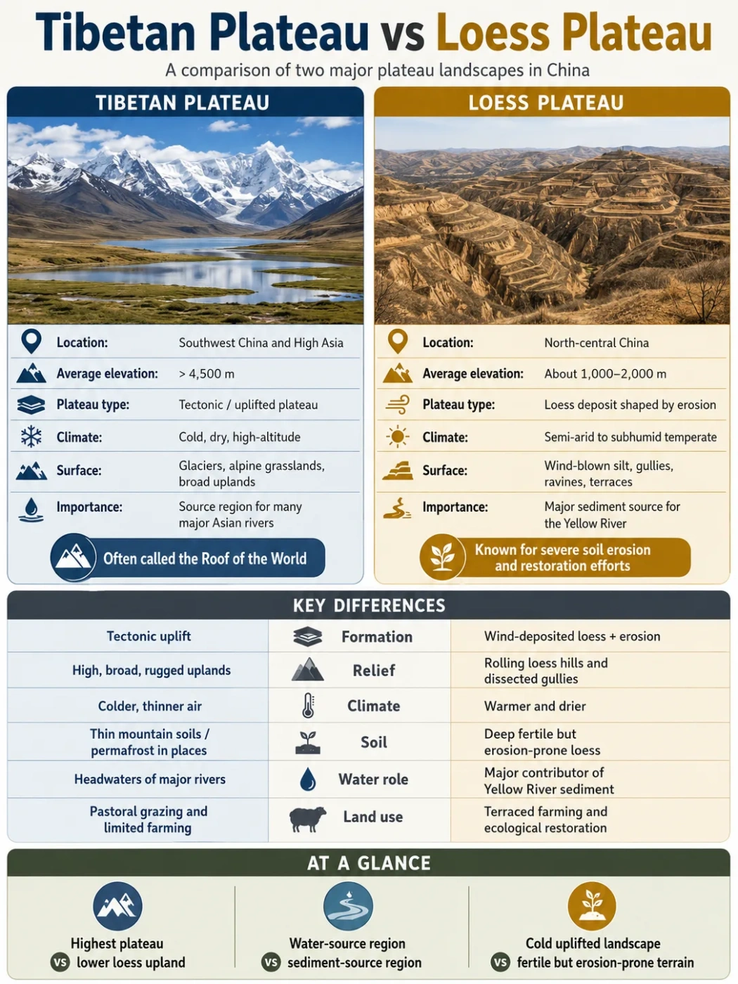
The Loess Plateau is often mentioned with other famous plateaus, but it belongs to a different category from most of them. It is not famous mainly for extreme elevation like the Tibetan Plateau. It is not mainly a lava-built surface like the Columbia Plateau. Its identity comes from wind-blown silt and erosion.
Loess Plateau
- Built mainly from wind-blown silt deposits
- Strongly linked to Yellow River sediment
- Deeply cut by gullies and small valleys
- Important for soil, farming, and watershed management
Hard-Rock or Lava Plateaus
- Often built from bedrock uplift or lava flows
- May have cliffs, canyons, or basalt layers
- Erode differently because the material is harder
- Often defined more by rock structure than soil behavior
| Plateau | Main Defining Feature | How It Differs From the Loess Plateau |
|---|---|---|
| Tibetan Plateau | Very high tectonic plateau | Much higher and linked strongly to continental collision and uplift; not defined by thick wind-blown silt cover. |
| Deccan Plateau | Large basalt and hard-rock plateau in India | Built largely from volcanic rock and long erosion, while the Loess Plateau is defined by aeolian silt. |
| Columbia Plateau | Basalt lava plateau in North America | Formed from repeated lava flows; its cliffs and canyons behave differently from soft loess gullies. |
| Colorado Plateau | Sedimentary rock plateau with canyons | Famous for exposed rock layers and canyon incision, not for thick loess deposits and yellow silt erosion. |
A Simple Rule for Remembering the Difference
If a plateau is known for height, think first about uplift. If it is known for lava layers, think first about volcanism. If it is known for yellow silt, gullies, and river sediment, the Loess Plateau is the model example.
Terms That Help Explain the Loess Plateau
Several landform terms make the plateau easier to understand. They are especially useful when reading maps, geography articles, or soil conservation studies about north-central China.
Loess
Fine wind-blown silt that can form thick yellowish deposits. On the Loess Plateau, it is the main material shaping soil, slopes, and erosion.
Aeolian Deposit
A sediment deposit made by wind action. The Loess Plateau is one of the best-known examples of a large aeolian landform region.
Dissected Plateau
A plateau that has been cut into valleys, ridges, and gullies by erosion. The Loess Plateau is highly dissected in many areas.
River Incision
The downward cutting of a river into the land. It helps create steep valleys and broken plateau surfaces.
Drainage Basin
The land area drained by a river and its tributaries. Much of the Loess Plateau is tied to the Yellow River drainage basin.
Terracing
The shaping of slopes into step-like fields. On the Loess Plateau, terraces help reduce runoff and support farming on sloping land.
Why the Loess Plateau Matters in Geography
The Loess Plateau matters because it connects several core geography ideas in one place: wind deposition, river erosion, sediment transport, climate gradients, farming, settlement, and land restoration.
It also helps explain how a plateau can be famous without being the highest or the largest by every measure. Its value as a geography example comes from the way its material behaves. Wind built the loess cover; water cut it apart; people shaped the slopes for farming and erosion control.
It Is a Natural Dust Archive
Loess layers can preserve evidence of past dust movement and climate shifts. Alternating loess and soil layers help scientists study changes in wind, moisture, vegetation, and regional climate over long periods.
It Is a River Sediment Source
The plateau shows how upland erosion can affect a major river. Fine sediment from gullies and slopes can move into the Yellow River system, changing water color, riverbed behavior, and downstream sediment patterns.
It Is a Human-Modified Plateau
The modern landscape includes terraces, planted slopes, villages, farmland, roads, reservoirs, and check dams. These features show how people work with a difficult but productive landform.
Data Confidence Note
Broad statements about the plateau’s location, loess origin, Yellow River connection, and average elevation are well established. Exact area, erosion rates, and population figures vary by study boundary, year, and definition, so they should be treated as approximate in general reference writing.
FAQ
What is the Loess Plateau?
The Loess Plateau is a large plateau region in north-central China made mainly of thick wind-blown silt called loess. It is strongly connected with the middle Yellow River basin and is known for gullies, terraces, yellow soil, and sediment movement.
Where is the Loess Plateau located?
It is located in north-central China, especially across parts of Shaanxi, Shanxi, eastern Gansu, and northern Henan. Broader definitions may include nearby parts of Ningxia, Inner Mongolia, and Qinghai because loess deposits and watershed boundaries extend across a wider region.
Why is it called the Loess Plateau?
It is called the Loess Plateau because much of its surface is covered by loess, a fine yellowish silt deposited by wind. This material gives the plateau its color, soil character, and high erosion sensitivity.
How did the Loess Plateau form?
The plateau formed as winds carried fine silt from dry interior and desert-margin areas and deposited it across north-central China over long periods. Later, rainfall, rivers, uplift, and runoff cut the loess into gullies, ridges, valleys, and terraces.
Is the Loess Plateau the same as a desert?
No. The Loess Plateau is not a desert, although much of its dust came from dry source areas. It is a loess-covered highland with farmland, villages, river valleys, grasslands, restored vegetation, and eroded slopes.
Why is the Loess Plateau important to the Yellow River?
The plateau is a major source of fine sediment for the Yellow River and its tributaries. When loess slopes erode, silt can enter streams and move into the wider river system, affecting water color, sediment load, and downstream river behavior.
How high is the Loess Plateau?
The plateau is often described as averaging about 1,200 meters above sea level, with many surfaces roughly between 900 and 2,100 meters. Local elevations vary because the region includes ridges, basins, valleys, and dissected uplands.
What makes the Loess Plateau different from the Tibetan Plateau?
The Tibetan Plateau is much higher and is mainly known for tectonic uplift and extreme elevation. The Loess Plateau is lower and is mainly known for thick wind-blown silt, gully erosion, farming terraces, and its connection to Yellow River sediment.