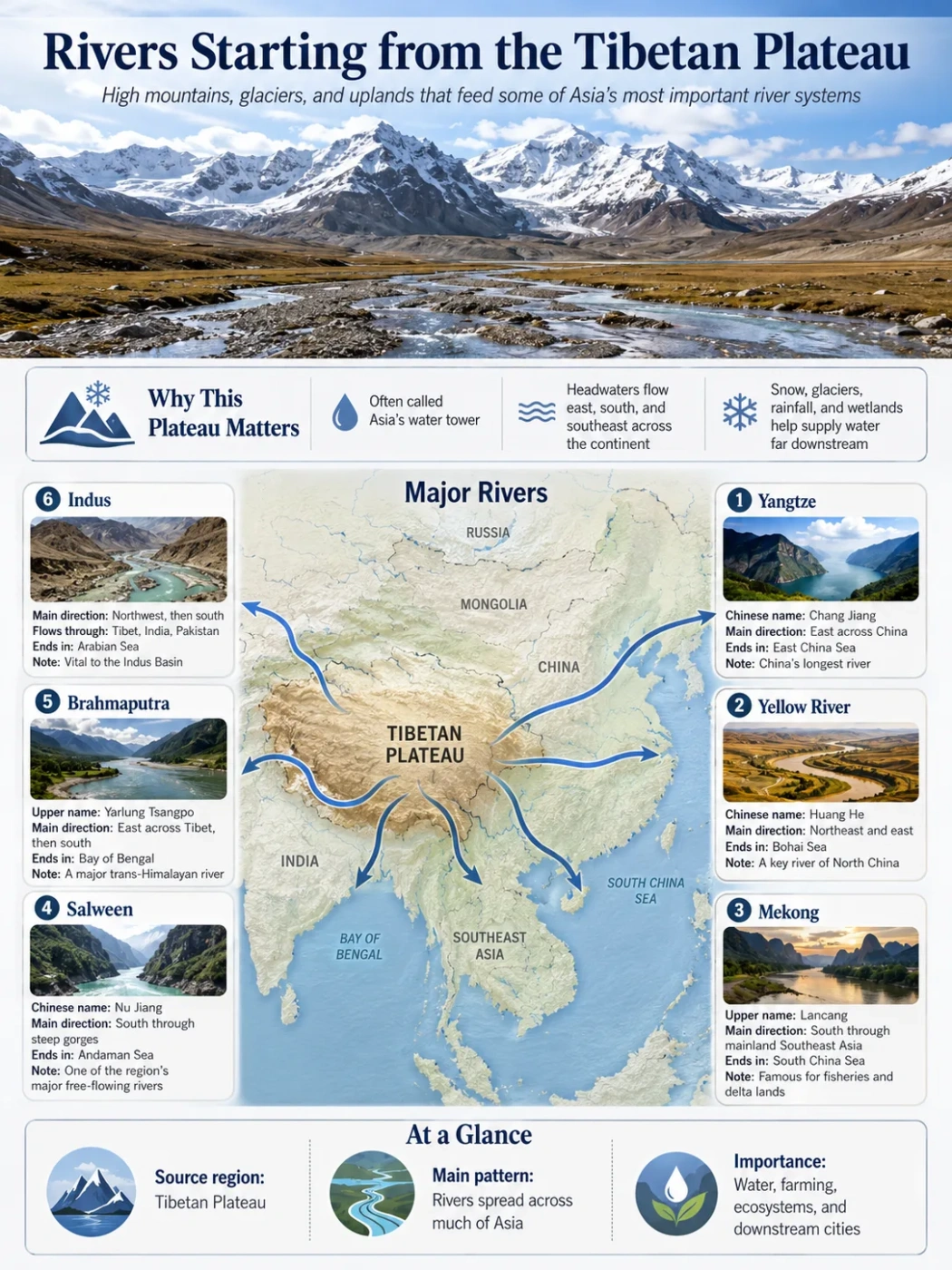
Asian Rivers and High-Plateau Drainage
The Tibetan Plateau forms the elevated source region of rivers that flow east across China, south through mainland Southeast Asia, west toward the Arabian Sea, and into the great plains of South Asia.
Pacific and Indian Ocean Drainage
Several Trans-Himalayan Rivers
Large Interior Basins
The best-known rivers starting from the Tibetan Plateau include the Yangtze, Yellow, Mekong, Salween, Brahmaputra, and Indus. The plateau also supplies major tributaries such as the Sutlej, Karnali, and Arun, while rivers along its northern rim feed the enclosed Tarim Basin.
This drainage pattern is possible because the plateau is both very high and very broad. Water collected in its mountains, alpine wetlands, snowfields, glaciers, lakes, and soils can be directed toward widely separated parts of Asia.
Geography Note
A river that starts on the Tibetan Plateau does not receive all of its water there. Most large rivers collect rainwater, groundwater, snowmelt, and tributary flow across much larger downstream basins.
Major Rivers With Tibetan Plateau Headwaters
The table covers the principal independent river systems and large tributaries consistently associated with the plateau. It does not attempt to list every short alpine stream or every river beginning in the surrounding Himalaya, Karakoram, Pamir, Qilian, or Hengduan ranges.
| River System | Upper or Regional Name | Source Sector | Main Downstream Route | Final Drainage | Geographic Status |
|---|---|---|---|---|---|
| Yangtze | Tuotuo, Dam Qu, Tongtian, and Jinsha in different upper reaches | Tanggula Mountains and adjoining wetlands in Qinghai | Flows east across China | East China Sea, Pacific Ocean | Direct plateau source |
| Yellow River | Huang He | Bayan Har Mountains and the Gyaring-Ngoring lake region of Qinghai | Leaves the northeastern plateau and crosses northern China | Bohai Sea, connected to the Pacific | Direct plateau source |
| Mekong | Lancang in China | High headwater country of southern Qinghai | China, Myanmar-Laos border region, Laos, Thailand border region, Cambodia, and Vietnam | South China Sea, Pacific Ocean | Direct plateau source |
| Salween | Gyalmo Ngulchu in Tibetan usage; Nu River in China | Tanggula Mountains of the central plateau | China, Myanmar, and part of the Myanmar-Thailand border | Andaman Sea, Indian Ocean | Direct plateau source |
| Brahmaputra | Yarlung Tsangpo, Siang or Dihang, and Jamuna along different reaches | Southwestern Tibet, north of the main Himalayan crest | China, India, and Bangladesh | Ganges-Brahmaputra-Meghna delta, Bay of Bengal | Direct plateau source |
| Indus | Sênggê Zangbo in its Tibetan upper course | Western Tibet near the Kailash-Mapam highland region | Western Tibet, Ladakh, and Pakistan | Arabian Sea, Indian Ocean | Direct plateau source |
| Sutlej | Langqên Zangbo | Western Tibet near the Rakshastal-Mapam region | China, India, and Pakistan | Joins the Indus system before reaching the Arabian Sea | Major plateau-born tributary |
| Karnali-Ghaghara | Mapcha Tsangpo in Tibet; Karnali in Nepal | Southern plateau margin north of the Himalayan crest | China, Nepal, and India | Ganges and then the Bay of Bengal | Major trans-Himalayan tributary |
| Arun | Phung Chu or Bum Chu in its upper basin | Tibet north of the Himalaya | Crosses south into Nepal and joins the Koshi system | Ganges and then the Bay of Bengal | Major trans-Himalayan tributary |
| Northern Tarim Tributaries | Includes the Yarkand and the Hotan headwater systems | Karakoram and Kunlun margins of the plateau | Flow into the Tarim Basin of Xinjiang | Interior drainage with no outlet to an ocean | Plateau-margin source systems |
Data Note
River sources can be defined by the longest headstream, highest perennial channel, traditional source, or most distant point from the mouth. These methods sometimes identify different glaciers, springs, or wetlands within the same headwater region.
How One Plateau Sends Water in Several Directions
Eastern Drainage
Yangtze and Yellow
Both rivers begin in Qinghai and cross much of China before entering seas connected to the Pacific Ocean.
Southeastern Drainage
Mekong and Salween
These rivers descend through the eastern plateau and the deeply divided terrain of the Hengduan Mountains.
Southern Drainage
Brahmaputra and Ganges Tributaries
They cross or bend around the Himalaya before entering the low plains of South Asia.
Western Drainage
Indus and Sutlej
These rivers leave western Tibet through high mountain corridors and eventually drain into the Arabian Sea.
Interior Drainage
Tarim and Closed Plateau Basins
Some rivers end in desert basins, saline lakes, wetlands, or dry terminal depressions without reaching an ocean.
The plateau does not behave like a simple dome with streams running evenly from its center. Mountain chains, fault zones, enclosed basins, old valleys, and differences in rainfall divide it into many separate catchments.
The Bayan Har Mountains, for example, help separate the upper Yellow River basin from the Yangtze basin. Farther south, the Tanggula region contains headwaters belonging to the Yangtze and Salween systems. Western Tibet sends neighboring rivers toward entirely different destinations: the Indus turns northwest, the Sutlej travels west through the Himalaya, and the Yarlung Tsangpo initially flows east.
The Yangtze and Yellow River Source Region
Yangtze Headwaters in the Tanggula Mountains
The Yangtze begins as a network rather than one immediately recognizable river. Its upper catchment includes glacial streams, wetlands, braided channels, and high lakes in the Tanggula Mountains and adjoining parts of Qinghai.
The Tuotuo River, associated with the Geladandong area, has traditionally been identified as a source branch. Hydrological measurements have also placed attention on the Dam Qu, whose headwaters may provide a longer source-to-sea route. The channels eventually form the Tongtian River and then the Jinsha River before the familiar lower Yangtze course develops.
From the plateau, the river descends through mountain valleys and crosses central and eastern China. Its full course is about 6,300 kilometres, making it the longest river in Asia.
Yellow River Headwaters in the Bayan Har Mountains
The Yellow River rises farther northeast in a landscape of alpine marshes, springs, small channels, and lakes. Source streams in the Bayan Har Mountains feed Gyaring Lake and Ngoring Lake (also written as Zhaling and Eling), which form prominent parts of the upper drainage system.
The young river follows a winding route across the northeastern plateau before leaving the highland region. It later makes a broad northern loop, turns south, and finally crosses the North China Plain to the Bohai Sea.
The upper river initially carries clear highland water. Much of the sediment associated with the river farther downstream is collected after it enters easily eroded terrain, especially the Loess Plateau.
Landform Note
The Yangtze and Yellow rivers begin relatively close together, but a high drainage divide directs them into separate routes. Nearby headwaters do not necessarily belong to the same river basin.
Mekong and Salween: Parallel Rivers From Eastern Tibet
The Upper Mekong, or Lancang
The Mekong begins among high springs and streams in southern Qinghai. In China, its upper and middle course is known as the Lancang River. It travels southeast from the plateau before entering the steep valleys of western Yunnan.
Beyond China, the river reaches or borders Myanmar, Laos, Thailand, Cambodia, and Vietnam. It ends through a broad delta on the South China Sea after a journey of roughly 4,900 kilometres.
Its headwater basin is cold and high, while its lower basin is tropical and strongly shaped by seasonal rainfall. The sharp environmental transition shows why a river cannot be understood only from conditions at its source.
The Salween, or Nu River
The Salween rises in the central plateau’s Tanggula region. Its Tibetan upper course is often called the Gyalmo Ngulchu, while the river is known as the Nu in China and the Salween farther downstream.
It flows east and southeast before turning south through Yunnan and Myanmar. Unlike the Mekong, it retains a long mountain-bound course and has a relatively narrow lower basin before entering the Andaman Sea.
The Three Parallel Rivers Landscape
In northwestern Yunnan, the upper Yangtze, Mekong, and Salween occupy adjacent north-south valleys. In places, only narrow mountain ranges separate their basins. The rivers remain distinct because the ridges of the Hengduan Mountains form strong drainage divides.
The Yangtze eventually turns northeast and east. The Mekong and Salween continue south through separate basins. Their close spacing makes eastern Tibet and western Yunnan one of the clearest examples of how uplift, river incision, and mountain barriers organize drainage.
The Brahmaputra Across and Around the Himalaya
The Brahmaputra begins in southwestern Tibet, where its upper course is called the Yarlung Tsangpo. The precise source has been assigned to the Angsi-Chemayungdung glacier region, although published descriptions differ over which headstream should carry the source designation.
For much of its Tibetan course, the river flows east along a broad valley between the Himalaya to the south and the Gangdise-Nyenchen Tanglha highlands to the north. This long eastward route is unusual because the Bay of Bengal lies far to the south.
Near the eastern end of the Himalaya, the river curves around the Namcha Barwa region and enters a deeply cut gorge. It then turns toward the south and southwest. In India it is known first as the Siang or Dihang and then as the Brahmaputra. In Bangladesh its main channel is called the Jamuna.
The Jamuna joins the lower Ganges, locally called the Padma, and their combined waters reach the Bay of Bengal through the Ganges-Brahmaputra-Meghna delta.
Map Note
The Yarlung Tsangpo-Brahmaputra should be followed as one connected river despite its changing regional names. The sharp bend near the eastern Himalaya is the main feature that links its high plateau course with the plains of Assam and Bangladesh.
Western Tibet and the Indus System
The Indus
The Indus rises in western Tibet near the Kailash and Lake Mapam region. Its upper Tibetan name, Sênggê Zangbo, is often translated as Lion River.
Descriptions sometimes state that the Indus begins in Lake Mapam (Manasarovar). A more careful description places its source among nearby springs and headwater channels rather than treating the lake as a simple river outlet.
The river initially flows northwest across high, dry terrain. It continues through Ladakh and mountain valleys farther west before turning south across Pakistan. After roughly 3,200 kilometres, it reaches the Arabian Sea through the Indus delta.
The upper basin receives water from snow, glaciers, and high-mountain precipitation. Farther downstream, tributaries from the Karakoram, Himalaya, Hindu Kush, and plains greatly enlarge the river system.
The Sutlej
The Sutlej starts near the nearby Rakshastal-Mapam lake region and flows west as the Langqên Zangbo. It crosses the Himalaya through a deep valley and continues through northern India before entering Pakistan and joining the wider Indus system.
Lake Rakshastal is commonly presented as the direct source of the Sutlej. The modern headwater connection is more complex. Springs and seasonal channels west of the lake form the active source, while changes in drainage and lake level have altered the relationship between the lake and river over time.
The Indus and Sutlej are both examples of trans-Himalayan rivers: their headwaters lie north of the main Himalayan crest, yet their courses cut through the mountain system.
Plateau-Born Tributaries of the Ganges Basin
The Ganges itself begins at the Gangotri glacier system on the southern side of the Himalaya, not on the open surface of the Tibetan Plateau. However, several large Ganges tributaries collect water north of the Himalayan crest.
Karnali-Ghaghara
The upper Karnali is called the Mapcha Tsangpo in Tibet. It flows south through the Himalaya into Nepal, where it becomes the Karnali. In India it is known as the Ghaghara before joining the Ganges.
This changing sequence of names can make the river appear as several separate waterways on regional maps. Hydrologically, they belong to one connected trans-Himalayan system.
Arun and the Koshi System
The Arun begins north of the Himalayan crest in Tibet, where its upper course is known by names including Phung Chu or Bum Chu. It crosses into Nepal through a deep north-south valley.
Farther south, the Arun joins the Sun Koshi and Tamur to form the Sapta Koshi system. The Koshi then enters the plains and joins the Ganges.
Other rivers of the Ganges basin begin in the Himalaya or adjoining highlands, but they should not all be described as Tibetan Plateau rivers. The position of the headwater relative to the plateau surface and the main Himalayan divide matters.
Rivers That Flow Into Interior Basins
Not all water leaving the plateau reaches an ocean. Much of the central and northern interior consists of endorheic drainage, meaning that water ends in an enclosed basin.
Short rivers may flow into saline lakes such as Siling Co or into other closed depressions across the interior plateau. Water leaves these basins mainly through evaporation, seepage, or storage in lake water and sediment rather than through an outlet river.
The Tarim Connection
Along the northern and northwestern margins, rivers descending from the Kunlun and Karakoram ranges help supply the Tarim system. The Yarkand and the two main branches forming the Hotan River carry mountain water toward the desert basin.
The Tarim should not be described as a river produced only by the Tibetan Plateau. Its basin also receives the Aksu River from the Tian Shan, a separate mountain system to the north. The combined river remains within the Tarim Basin and has no natural route to an ocean.
Qaidam and Northeastern Closed Drainage
The Qaidam Basin on the plateau’s northeastern side contains short rivers that descend from surrounding mountains and end in salt lakes, marshes, or dry basin floors. Similar drainage occurs in parts of the plateau interior where evaporation is high and mountain barriers prevent outward flow.
Common Mix-Up
An inland river is not necessarily a failed branch of an ocean-bound river. Closed basins are normal drainage systems formed where surrounding land is higher than the basin floor and no low outlet reaches the sea.
How Plateau Water Becomes a Large River
Water Collects at High Elevation
Rain, snow, glacier ice, frozen ground, springs, and wetlands store or release water within the upper catchment.
Small Channels Join
Seasonal streams and perennial headwaters merge into larger braided or single-channel rivers.
Rivers Cross Mountain Belts
Established valleys guide water through deep gorges, tectonic depressions, and gaps between ranges.
Downstream Tributaries Enlarge the Flow
Monsoon rain, groundwater, local runoff, and tributaries often supply much of the water measured in the lower basin.
The balance among these water sources differs from one basin to another. The upper Brahmaputra, Salween, Mekong, Yangtze, and Yellow basins receive much of their annual input from precipitation. Snow and glaciers still affect seasonal timing, especially in high tributaries.
The upper Indus and some northern interior basins are drier. Snow and glacier melt therefore form a larger share of their mountain runoff, particularly during warm months. Groundwater and thawing seasonally frozen soils can also help maintain flow between storms.
Calling every plateau river “glacier-fed” is therefore too simple. Some source branches begin at glaciers, while others emerge from wetlands, springs, snowfields, or rainfall-fed channels.
How Uplift and River Incision Shaped the Drainage
The Tibetan Plateau developed through the collision and continuing convergence of the Indian and Eurasian plates. Uplift raised broad areas while faults, folding, erosion, and crustal deformation created mountain ranges and basins within the highland.
Rivers responded by shifting courses, capturing neighboring streams, cutting into rising terrain, or becoming enclosed within interior depressions. Some valleys may predate part of the present relief. Rivers that maintained their courses while mountains rose could cut deep gorges across the developing ranges.
This history helps explain several otherwise puzzling patterns:
- The Yarlung Tsangpo flows east for a long distance before turning south around the eastern Himalaya.
- The Indus and Sutlej cross major mountain ranges instead of following the shortest surface route around them.
- The Yangtze, Mekong, and Salween occupy tightly spaced but separate valleys in the eastern highlands.
- Central plateau rivers often terminate in lakes because enclosed basins lack an external outlet.
Modern drainage is therefore the result of both present-day slope and a much longer history of uplift, erosion, and river reorganization.
Rivers Often Grouped With the Plateau but Requiring Care
Ganges
The Ganges belongs to the wider Hindu Kush-Himalaya drainage region, but its accepted headwaters rise in the Himalaya south of the Tibetan Plateau. Tibetan headwaters enter its basin through tributaries such as the Karnali-Ghaghara and Arun-Koshi systems.
Irrawaddy
The Irrawaddy proper begins where the N’mai and Mali rivers meet in northern Myanmar. Parts of its remote headwater region reach the eastern Himalayan margin, but calling the entire Irrawaddy a direct Tibetan Plateau river depends on using a broader High Mountain Asia boundary.
Amu Darya
The Amu Darya is usually traced to the Pamir and Hindu Kush highlands west of the Tibetan Plateau. It is part of the wider Asian mountain-water system, but it is not normally placed among rivers rising on the plateau proper.
Red River
The Red River begins in the uplands of Yunnan. Its drainage history is related to the tectonic development of the eastern plateau margin, yet its modern source lies south and east of the main Tibetan Plateau.
Field Note
Tibetan Plateau, Himalaya, and High Mountain Asia are not interchangeable names. High Mountain Asia is the broadest term and can include the Tibetan Plateau, Himalaya, Karakoram, Pamir, Hindu Kush, and other neighboring ranges.
Why River Names Change Downstream
Many rivers cross several language regions and distinct physical landscapes. Their names may change when they leave Tibet, enter another country, merge with a tributary, or divide into delta channels.
- Yarlung Tsangpo becomes the Siang or Dihang, then the Brahmaputra, and later the Jamuna.
- Lancang is the Chinese name used for the upper Mekong.
- Nu is the Chinese name used for the Salween.
- Sênggê Zangbo is the Tibetan upper Indus.
- Langqên Zangbo is the Tibetan upper Sutlej.
- Mapcha Tsangpo becomes the Karnali and later the Ghaghara.
- The upper Yangtze is divided into named reaches including the Tuotuo, Tongtian, and Jinsha.
A change of name does not automatically indicate a new river. The connected channel, tributary structure, and drainage basin provide the clearer geographic test.
Frequently Asked Questions
Which Major Rivers Begin on the Tibetan Plateau?
The main independent systems are the Yangtze, Yellow, Mekong, Salween, Brahmaputra, and Indus. The plateau also supplies large tributaries including the Sutlej, Karnali-Ghaghara, and Arun.
Why Do So Many Rivers Start Near the Tibetan Plateau?
The plateau is extremely high, covers a wide area, and is surrounded by major mountain ranges. Its elevation allows water to flow toward eastern China, Southeast Asia, South Asia, Central Asian interior basins, and the Arabian Sea.
Does the Ganges Start on the Tibetan Plateau?
No. The accepted Ganges headwaters begin in the Himalaya in northern India. However, major tributaries of the Ganges, including the Karnali-Ghaghara and Arun-Koshi systems, collect water north of the Himalayan crest.
Do Tibetan Plateau Rivers Get Most of Their Water From Glaciers?
Not in every basin. Rainfall supplies much of the annual water in several eastern and southern rivers. Snow, glaciers, groundwater, wetlands, and frozen soils affect the amount and seasonal timing of flow, with meltwater playing a larger relative role in some dry western basins.
Which Tibetan Plateau Rivers Reach the Pacific Ocean?
The Yangtze and Yellow rivers reach seas connected to the Pacific. The Mekong reaches the South China Sea, which is also part of the Pacific Ocean system.
Which Plateau Rivers Reach the Indian Ocean?
The Indus reaches the Arabian Sea, while the Brahmaputra joins the Ganges-Meghna system before entering the Bay of Bengal. The Salween reaches the Andaman Sea. The Sutlej reaches the Indian Ocean indirectly through the Indus.
Are There Rivers on the Plateau That Never Reach the Sea?
Yes. Rivers in endorheic basins terminate in lakes, wetlands, desert depressions, or dry channels. This occurs across the central plateau, the Qaidam Basin, and the Tarim drainage region along the northern margin.
Why Do These Rivers Have Several Names?
They cross different language regions and may acquire new names at major confluences or geographic transitions. Yarlung Tsangpo, Brahmaputra, and Jamuna, for example, identify connected reaches of the same river system.