High Plateau Profile
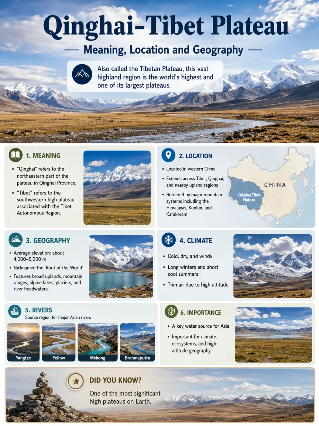
The Qinghai-Tibet Plateau is the high, wide upland of western China and surrounding High Asia, often described as the highest and largest plateau on Earth. It is not a single flat surface, but a raised landform system of basins, mountains, lakes, grasslands, glaciers and major river headwaters.
The name Qinghai-Tibet Plateau is commonly used for the vast highland centered on Qinghai and Tibet. It is also called the Tibetan Plateau or Qingzang Plateau. In geography, these names usually point to the same broad elevated region, although exact boundaries can vary by map, study and definition.
This plateau matters because it shapes climate, drainage and landforms across a large part of Asia. Its height affects winds and monsoon patterns, while its glaciers, snowfields, lakes and wetlands feed some of the continent’s best-known rivers.
| Feature | Qinghai-Tibet Plateau Profile |
|---|---|
| Name | Qinghai-Tibet Plateau, Tibetan Plateau, Qingzang Plateau |
| Main Location | Western China, mainly Tibet Autonomous Region and Qinghai, with margins reaching nearby highland regions |
| Approximate Area | Often described as about 2.5 million square kilometers |
| Average Elevation | About 4,500 meters above sea level |
| Landform Type | High tectonic plateau with internal basins, mountain ranges, valleys, lakes and glaciated terrain |
| Major Mountain Edges | Himalayas to the south, Kunlun and related ranges to the north, Hengduan Mountains toward the east and southeast |
| Climate Pattern | Cold highland climate, dry interior zones, alpine steppe and meadow, stronger monsoon influence toward the south and east |
| Known For | Extreme elevation, Asian river headwaters, broad alpine landscapes, large lakes and strong climate influence |
Map Note
The Qinghai-Tibet Plateau should not be read as the same thing as the political region of Tibet. On physical maps, the plateau is a landform. Its natural edges follow high mountains, basins, escarpments and drainage divides rather than simple administrative borders.
What Does Qinghai-Tibet Plateau Mean?
The term Qinghai-Tibet Plateau combines Qinghai and Tibet, two names closely tied to the plateau’s core area. The Chinese term Qingzang Gaoyuan is also widely used, where “Qing” refers to Qinghai and “Zang” refers to Tibet.
In simple geography terms, the name means the high plateau region of Qinghai and Tibet. It describes a physical landform: a huge elevated surface that has been lifted far above the surrounding lowlands.
The word plateau does not mean perfectly flat. The Qinghai-Tibet Plateau includes broad upland plains, but it also contains mountain chains, deep valleys, salt lakes, wetlands, glaciers, river gorges and rolling alpine grassland.
Common Mix-Up
Qinghai-Tibet Plateau, Tibetan Plateau and Qingzang Plateau are often used for the same broad highland. “Tibet” alone can refer to a cultural, historical or administrative region, so it is not always the same as the plateau as a landform.
Where Is the Qinghai-Tibet Plateau Located?
The Qinghai-Tibet Plateau sits in High Asia, mainly in western China. Its core covers much of the Tibet Autonomous Region and Qinghai Province. Depending on the boundary used, related plateau margins may extend toward parts of Sichuan, Gansu, Xinjiang and Yunnan.
On a broad physical map, the plateau lies north of the Himalayas and south of the dry basins and deserts of Central Asia. It forms a high interior platform between some of the world’s tallest and most complex mountain systems.
Southern Edge
Himalayan Boundary
The Himalayas mark the plateau’s dramatic southern rim. South of this edge, land drops toward South Asia through steep valleys and mountain fronts.
Northern Edge
Kunlun and Dry Basins
The northern side is linked with the Kunlun Mountains and nearby dry interior basins, including areas toward the Tarim Basin.
Eastern Edge
Broken Mountain Country
To the east and southeast, the plateau breaks into deep valleys, parallel ranges and river gorges, especially around the Hengduan Mountains.
Interior
Basins, Lakes and Grasslands
The interior contains high basins, alpine steppe, salt lakes, wetlands and broad uplands rather than one smooth table-like plain.
How High Is the Qinghai-Tibet Plateau?
The plateau is commonly described as averaging about 4,500 meters above sea level. Many areas sit above 4,000 meters, while surrounding mountain ranges rise much higher.
This elevation explains why the plateau is often called the Roof of the World. The phrase is informal, but it captures the main geographic idea: a wide land surface lifted to an altitude where air is thinner, temperatures are lower and growing seasons are shorter.
Elevation Note
Average elevation figures vary because researchers and mapmakers do not always draw the plateau boundary in the same way. A value near 4,500 meters is widely used, but local elevations differ greatly between basins, valleys, lakes and mountain slopes.
What Type of Landform Is It?
The Qinghai-Tibet Plateau is a tectonic plateau. It formed mainly through crustal shortening, uplift and thickening linked to the collision of the Indian and Eurasian plates. This process did not create a smooth block all at once. It built a wide, uneven highland through long periods of compression, faulting, uplift and erosion.
The result is a raised region with several landform styles:
- High basins where lakes, wetlands and sediment collect.
- Mountain belts that rise within and around the plateau.
- River valleys that cut into the uplifted surface.
- Glaciated areas in colder and higher mountain zones.
- Alpine steppe and meadow across broad upland surfaces.
Plate Collision Begins
The Indian Plate moves northward into Eurasia. The crust between them shortens and thickens over long geological periods.
Crust Thickens and Rises
As the crust thickens, large parts of the region rise to high elevation. The uplift creates a broad plateau rather than only one mountain chain.
Basins and Ranges Develop
Faulting, folding and uneven uplift shape internal basins, mountain ridges and high valleys across the plateau surface.
Rivers and Ice Reshape the Surface
Rivers, glaciers, frost action and weathering cut valleys, move sediment and keep changing the plateau’s edges and interior landscapes.
Climate and Landscape
The plateau’s climate is strongly shaped by elevation. High altitude keeps temperatures low, even where sunlight is strong. Many interior areas are dry because surrounding mountains block moisture and because cold air holds less water vapor.
The landscape changes from place to place. The northern and central areas include cold, dry steppe, bare uplands and many saline lakes. The eastern and southeastern margins are more strongly affected by summer moisture and river incision, so they include deeper valleys, forested slopes in some zones and more broken terrain.
| Landscape Zone | Typical Features | Geographic Meaning |
|---|---|---|
| Central Interior | Cold uplands, steppe, basins, salt lakes | Shows the plateau’s dry highland character |
| Northern Plateau | High basins, sparse vegetation, links to dry Asian interiors | Connects the plateau with desert and basin landscapes to the north |
| Southern Rim | High mountains, glaciers, steep drainage toward South Asia | Forms a major divide between plateau interior and Himalayan front |
| Eastern and Southeastern Margins | Deep valleys, parallel rivers, rugged mountain belts | Marks the transition from high plateau to lower, wetter regions |
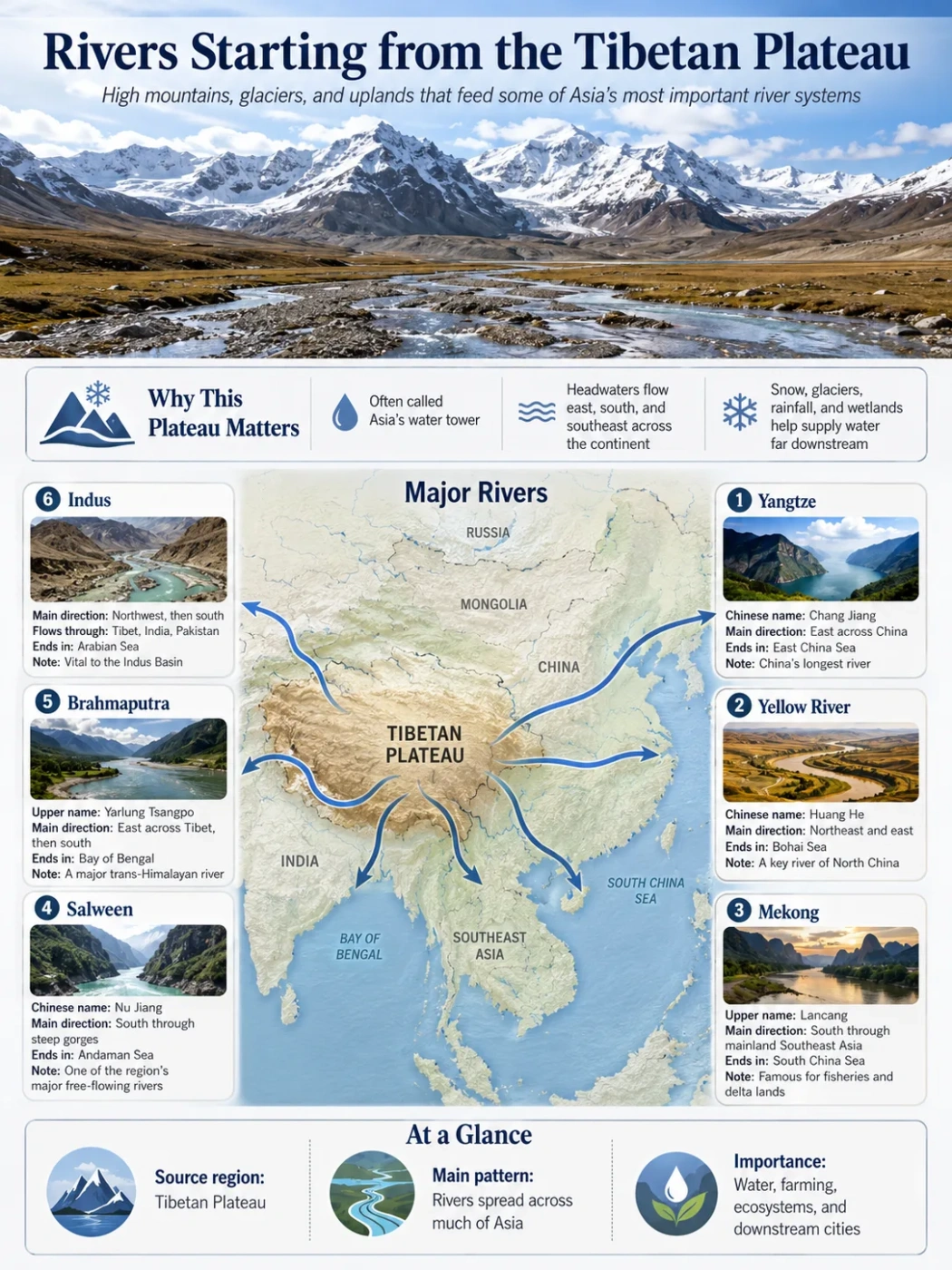
Rivers and Basins of the Qinghai-Tibet Plateau
The Qinghai-Tibet Plateau is one of Asia’s major water-source regions. Several large rivers begin on or near the plateau, then flow outward toward East Asia, South Asia and Southeast Asia.
This is why the plateau is often described as an Asian water tower. The phrase does not mean that all water comes from glaciers. It means the highland stores and releases water through snow, ice, lakes, wetlands, rainfall, groundwater and seasonal runoff.
| River or River System | Plateau Connection | General Flow Direction |
|---|---|---|
| Yangtze River | Headwaters linked to the eastern plateau region | Flows east across China |
| Yellow River | Rises in the highlands of Qinghai | Flows through northern China |
| Mekong River | Known in its upper course as the Lancang River | Flows south toward mainland Southeast Asia |
| Salween River | Known in its upper course as the Nu River | Flows south toward Myanmar and the Andaman Sea |
| Brahmaputra River | Known on the plateau as the Yarlung Tsangpo | Flows east across southern Tibet, then turns toward South Asia |
| Indus River | Linked to the western plateau and nearby high mountain region | Flows toward South Asia |
Geography Note
The plateau is not one single drainage basin. It is a high divide where rivers flow in different directions. Some basins are closed and feed lakes inside the plateau, while others send water toward large river systems outside it.
Lakes, Wetlands and Interior Drainage
Many parts of the plateau contain lakes, including freshwater lakes, brackish lakes and saline lakes. Some lie in closed basins where water does not reach the sea. In these areas, evaporation can leave salts behind, especially in drier interior zones.
Qinghai Lake is one of the best-known lakes connected to the plateau region. Farther across the highlands, many smaller lakes and wetlands help store water, support alpine ecosystems and mark low points inside basins.
These lake basins are important for reading the plateau on a map. A cluster of lakes often shows that the surface is high, cold and internally drained, rather than cut by a single outward-flowing river network.
Why the Plateau Is Not Just a Flat Tableland
The word plateau can create a misleading image. The Qinghai-Tibet Plateau is elevated, but it is not a level tabletop. Its surface includes mountains, rolling uplands, broad basins, sharp escarpments and deeply cut river valleys.
Simple Plateau Idea
- High land surface
- Often broad and raised
- May look flat on small-scale maps
- Useful as a basic definition
Qinghai-Tibet Reality
- Very high and very wide
- Contains basins, ranges and valleys
- Edges drop sharply in some areas
- Shaped by uplift, rivers, ice and climate
Nearby Mountains and Escarpments
The plateau is framed by major mountain systems. These ranges help define its edges and explain why the region is so high, dry and geomorphically complex.
- Himalayas: the high southern rim, with steep relief toward South Asia.
- Kunlun Mountains: a major northern boundary zone separating the plateau from dry basins to the north.
- Qilian Mountains: a northeastern range linked with the transition toward the Hexi Corridor and northern China.
- Hengduan Mountains: a rugged eastern and southeastern transition zone cut by major rivers.
- Karakoram and Pamir connections: western high mountain systems tied to the broader High Asia region.
These mountain edges make the plateau easier to recognize. On relief maps, the plateau appears as a large high block bordered by some of the strongest elevation contrasts on Earth.
Human Geography and Settlement
Human life on the plateau is shaped by altitude, cold, seasonal water and grassland resources. Settlements often occur in valleys, around river corridors, near lakes or in areas where grazing and limited farming are possible.
Pastoral landscapes are common across many highland areas. Yaks, sheep and goats are closely linked with the plateau environment because they can use cold alpine grasslands that are difficult for many lowland farming systems.
Roads, towns and rail routes must deal with elevation, frost, permafrost, thin air and long distances. These physical conditions are part of the plateau’s geography, not just background details.
Data Note
Area, elevation and boundary figures for the Qinghai-Tibet Plateau vary between maps and studies. The plateau is best understood as a broad physical region with transitional edges, not as a sharply fenced landform with one universally fixed outline.
How It Differs From Other Famous Plateaus
The Qinghai-Tibet Plateau is often compared with other large plateaus because of its height and size. The comparison is useful, but the plateau stands out because it combines very large area with very high average elevation.
| Plateau | Main Region | What Makes It Different |
|---|---|---|
| Qinghai-Tibet Plateau | High Asia | Extremely high average elevation, broad tectonic uplift, major Asian river headwaters |
| Altiplano | Andes, South America | High intermontane plateau between Andean ranges, with large basins and salt flats |
| Deccan Plateau | India | Large volcanic and erosional plateau at much lower average elevation |
| Colorado Plateau | Southwestern United States | Known for layered rock, canyons, mesas and river erosion |
| Iranian Plateau | Southwest Asia | Large highland region with basins, deserts and surrounding mountain belts |
How to Recognize It on a Physical Map
On a physical map, the Qinghai-Tibet Plateau appears as a large high-elevation zone north of the Himalayas. It is usually shown with strong elevation coloring, many mountain labels and several major rivers beginning near or within it.
A simple way to read it:
- Find the Himalayas first.
- Look north of the Himalayan crest for the broad highland area.
- Notice the major rivers flowing away from the plateau in different directions.
- Check for internal lakes and basins across the central and northern parts.
- Follow the eastern edge where the land breaks into deep river valleys and parallel mountain ranges.
Field Note
A plateau can look smooth on a small classroom map because the map scale hides local relief. At closer scale, the Qinghai-Tibet Plateau shows strong variation: basins, ridges, valleys, lake shores, glacier areas and steep river corridors.
Useful Geography Terms
Plateau
A raised land area that is broad compared with nearby mountains or valleys. It may be flat, rolling or broken by rivers and ranges.
Highland
A general term for elevated land. The Qinghai-Tibet Plateau is a highland, but it is more specifically a very large plateau.
Basin
A lower area within surrounding higher land. On the plateau, basins may hold lakes, wetlands, sediments or internal drainage systems.
Escarpment
A steep slope or edge where land drops from higher ground to lower ground. Plateau margins often include escarpments or sharp relief zones.
Uplift
The raising of land through geological processes. The Qinghai-Tibet Plateau is strongly linked with tectonic uplift.
Drainage Divide
A boundary between river systems. The plateau contains high divides that send water toward different parts of Asia.
FAQ
Is the Qinghai-Tibet Plateau the same as the Tibetan Plateau?
In most geography contexts, yes. Qinghai-Tibet Plateau, Tibetan Plateau and Qingzang Plateau usually refer to the same broad highland region. Exact boundaries can still vary by map or research source.
Where is the Qinghai-Tibet Plateau located?
It is located mainly in western China, especially across Tibet and Qinghai. Its wider physical margins connect with nearby highland areas and mountain systems in High Asia.
Why is the Qinghai-Tibet Plateau so high?
Its height comes mainly from tectonic uplift linked to the collision between the Indian and Eurasian plates. Crustal shortening and thickening helped raise a huge area into a high plateau over long geological time.
Is the Qinghai-Tibet Plateau flat?
No. It is a plateau because it is a broad raised region, but it includes mountains, basins, river valleys, glaciers, lakes, grasslands and steep edges. It is not a smooth flat tableland.
Which major rivers begin on or near the plateau?
Major river systems connected with the plateau include the Yangtze, Yellow River, Mekong, Salween, Brahmaputra and Indus. Some rivers begin in plateau headwater zones, while others are linked to nearby high mountain margins.
Why is the plateau called the Roof of the World?
The nickname refers to its very high average elevation and vast size. Large parts of the plateau sit around or above 4,000 meters, with surrounding mountain ranges rising even higher.
What climate does the Qinghai-Tibet Plateau have?
Much of the plateau has a cold highland climate. Interior areas are often dry, while the southern and eastern margins can receive more seasonal moisture. Elevation, mountains and wind patterns create strong local variation.
Why is the Qinghai-Tibet Plateau important in geography?
It affects climate, river systems, ecosystems and settlement patterns across a large part of Asia. Its elevation helps shape monsoon behavior, stores water in snow, ice, lakes and wetlands, and feeds major rivers that flow far beyond the plateau.