Plateau Comparison | Central and East Asia
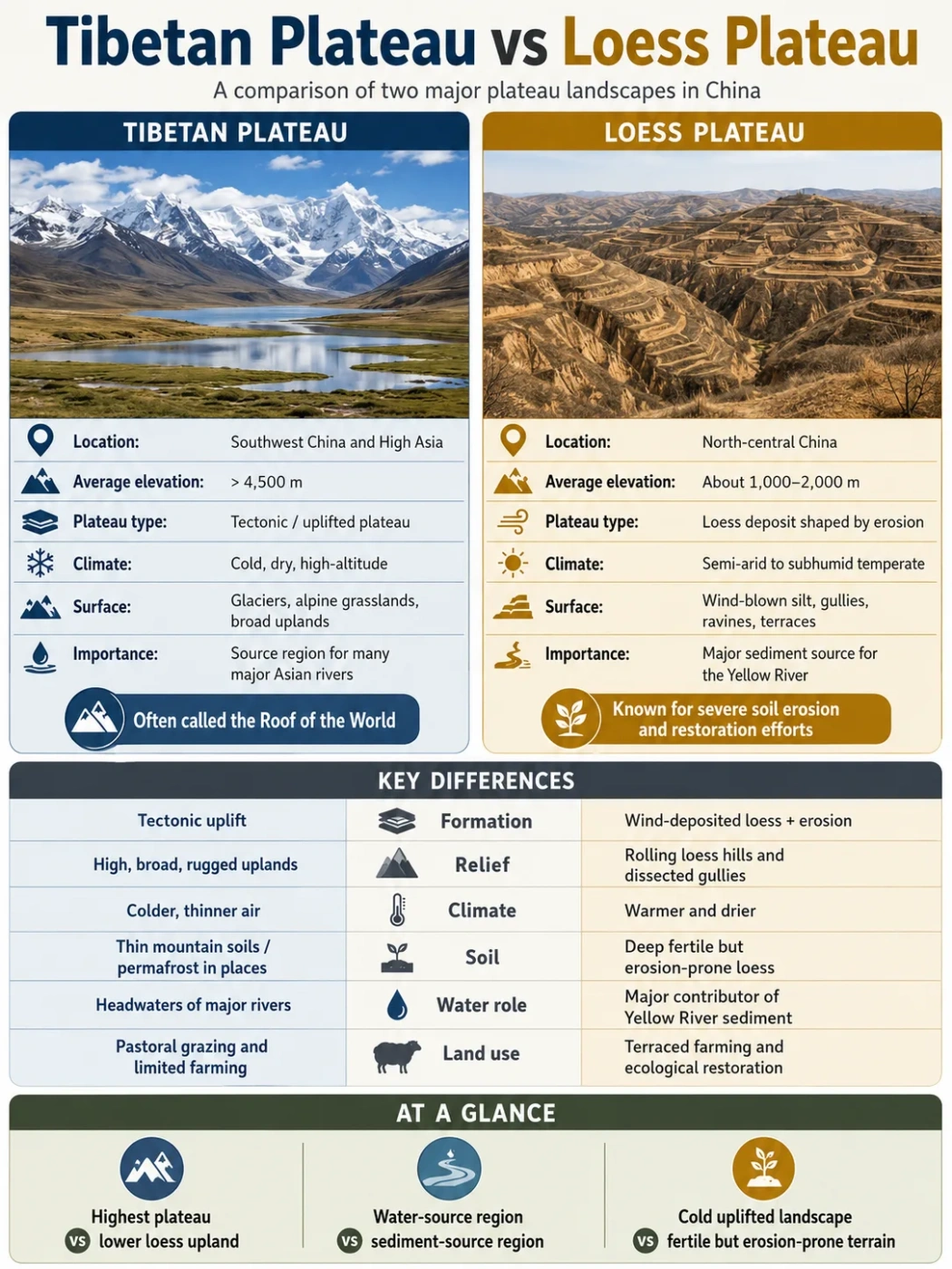
The Tibetan Plateau and the Loess Plateau are vast elevated regions linked by wind, sediment and the Yellow River, yet they represent very different kinds of landscape. One is a high tectonic plateau built through continental collision. The other is a lower sediment-covered plateau shaped by dust deposition and deep erosion.
The Tibetan Plateau is much higher, larger and more tectonically active than the Loess Plateau. It covers roughly 2.5 million square kilometres and forms the elevated core of High Asia. The Loess Plateau covers about 600,000–650,000 square kilometres in north-central China. Its identity comes mainly from a thick mantle of wind-deposited silt rather than extreme elevation.
| Comparison | Tibetan Plateau | Loess Plateau |
|---|---|---|
| Alternative Name | Qinghai–Tibet Plateau; Qing–Zang Plateau | Chinese Loess Plateau; Huangtu Plateau |
| Broad Location | Central and southwestern China, with adjoining highlands extending toward South and Central Asia | North-central China, mainly within the middle Yellow River basin |
| Approximate Area | About 2.5 million km² | About 600,000–650,000 km², depending on the boundary used |
| Typical Elevation | Much of the interior lies between 4,000 and 5,000 m; average elevation is often given as more than 4,500 m | Much of the main region lies between about 800 and 3,000 m, rising toward the west |
| Main Plateau Type | High orogenic and tectonic plateau | Depositional and deeply dissected loess plateau |
| Dominant Surface Material | Faulted and folded crust, mountain belts, sedimentary basins, glacial deposits and exposed bedrock | Wind-blown silt over older bedrock and basin surfaces |
| Main Formation Process | Crustal shortening, thickening, underthrusting and uplift associated with India–Eurasia convergence | Repeated dust deposition followed by soil formation, runoff erosion and river incision |
| Characteristic Terrain | High plains, internal basins, mountain chains, glaciers, permafrost, lakes and broad river valleys | Loess tablelands, ridges, rounded hills, steep-walled gullies and terraced slopes |
| Climate Pattern | Cold and generally dry in the interior; wetter toward parts of the south and east | Arid to subhumid continental monsoon climate, with a dry northwest and wetter southeast |
| River Role | Headwater region for several major Asian river systems | Major sediment-producing part of the middle Yellow River basin |
| Human Land Use | Pastoralism, valley agriculture, irrigated farming and settlement in sheltered basins | Terraced dryland farming, orchards, valley settlement and soil-conservation land use |
Measurement Note
Published area and elevation figures vary because researchers do not always draw the outer margins in the same place. Values for the Loess Plateau also change depending on whether bordering mountains, river plains and thin loess deposits are included. The ranges shown here are better comparison tools than a single rigid boundary.
Where the Two Plateaus Sit
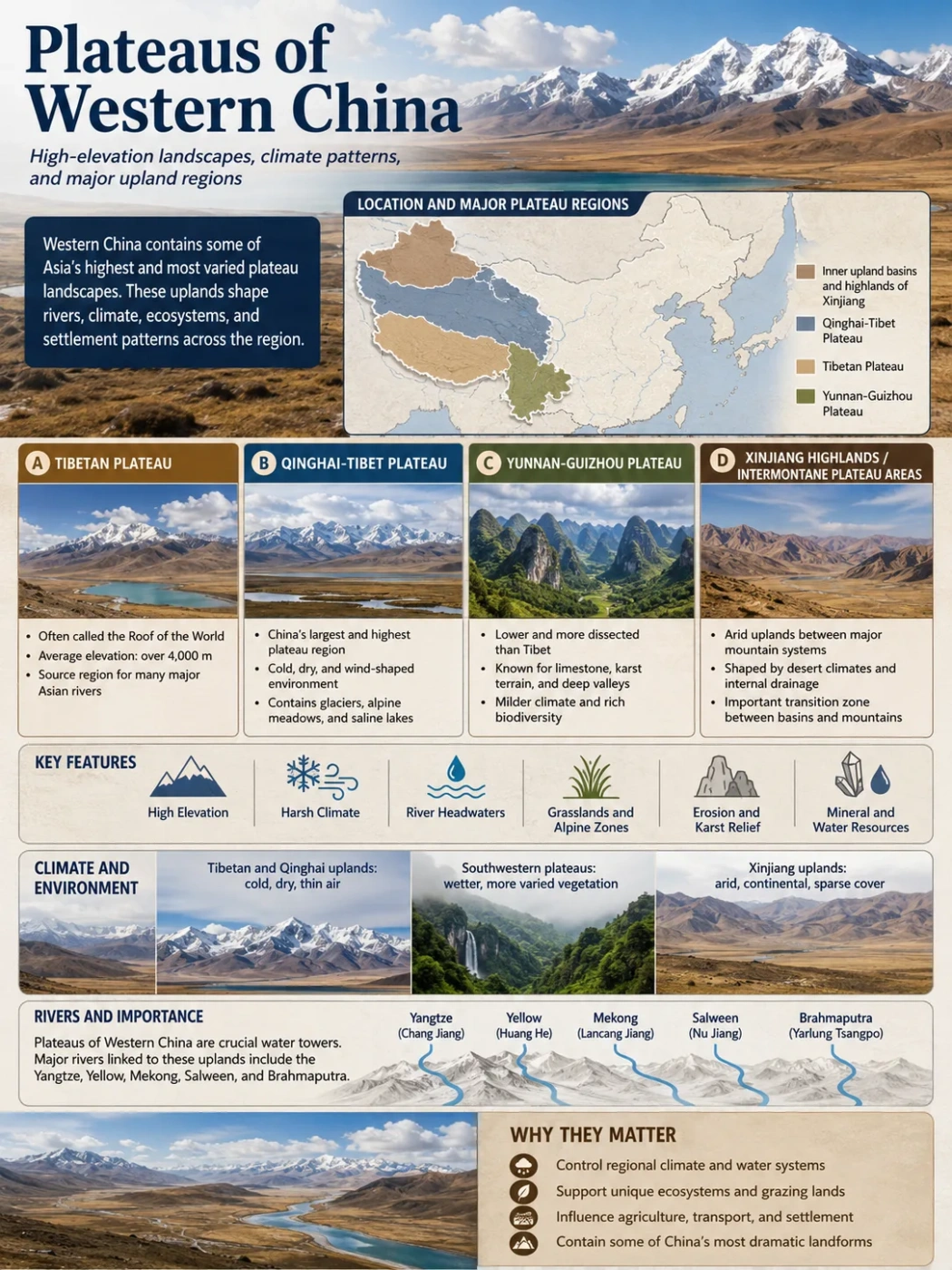
The Tibetan Plateau occupies the elevated interior north of the Himalayas. It covers most of the Tibet Autonomous Region and Qinghai, together with parts of western Sichuan, southern Gansu, northwestern Yunnan and southern Xinjiang under broader physical definitions. The Himalayas border it to the south, while the Karakoram, Kunlun, Qilian and other ranges mark or cross its margins.
Tibetan Plateau Location
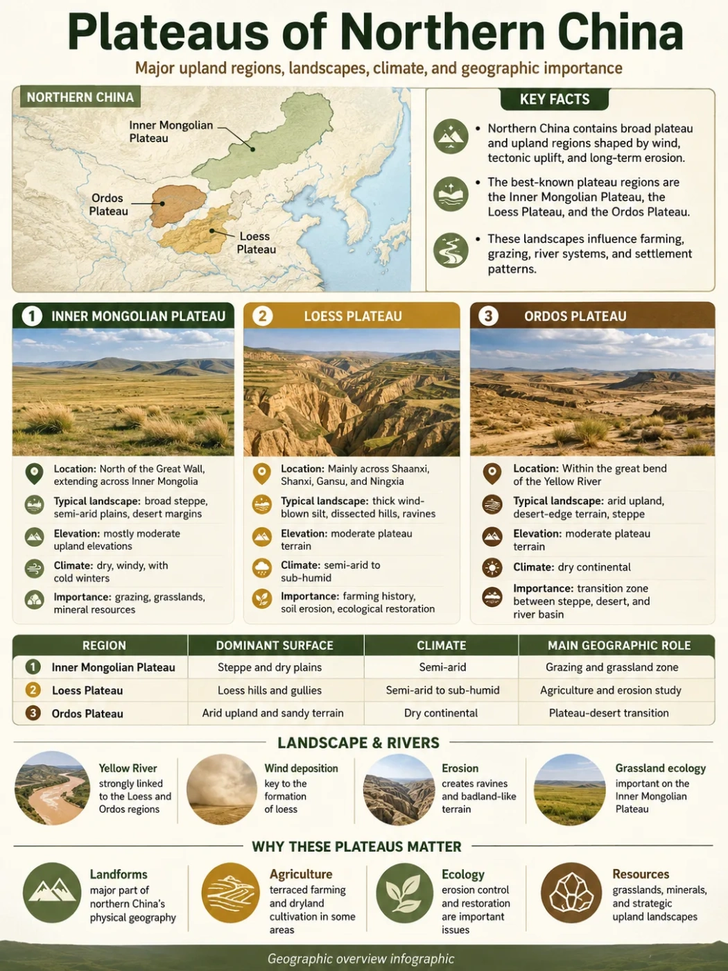
The Loess Plateau lies farther east and northeast. It extends across much of Shaanxi and Shanxi and into Gansu, Ningxia, Inner Mongolia, Henan and eastern Qinghai. The exact provincial share depends on the geomorphic boundary used. The Taihang Mountains stand near its eastern side, the Qinling Mountains mark much of its southern limit, and drier uplands and deserts lie toward the north and northwest.
Loess Plateau Location
Map Note
Google Maps provides general orientation rather than scientific plateau boundaries. The transition between the northeastern Tibetan Plateau, the Qilian ranges, the upper Yellow River country and the western Loess Plateau includes mountains, basins and loess-covered highlands that do not form a sharp line.
Two Different Meanings of Plateau
A plateau does not need to be perfectly level. It is a broad elevated region that stands above adjoining terrain, but its surface can contain hills, mountains, valleys and basins.
The Tibetan Plateau is elevated at the scale of the continental crust. Its surface remains extremely high across a vast distance, even where local relief is modest. Mountain belts rise above the plateau floor, while enclosed basins and wide valleys sit between them.
The Loess Plateau is defined more by its sediment cover and erosional landforms. Some remnants preserve broad surfaces, but river networks have divided large areas into ridges, hills and closely spaced gullies. It is therefore widely described as a dissected plateau.
Common Mix-Up
The word “plateau” does not imply that the two regions have similar geology. The Tibetan Plateau is an uplifted orogenic region made from thickened continental crust. The Loess Plateau is an older regional surface and bedrock landscape buried beneath extensive wind-blown sediment and then cut by water erosion.
How Their Formation Paths Differ
Tibetan Plateau
- Developed within an active continent–continent collision zone.
- Contains terranes and mountain belts assembled before and during the India–Eurasia collision.
- Was raised through crustal shortening, thickening, faulting, underthrusting and deeper mantle processes.
- Continues to deform along thrust, strike-slip and normal faults.
Loess Plateau
- Developed on older crustal blocks, basins and mountain margins.
- Received repeated layers of wind-blown silt from northern and western source regions.
- Preserves alternating loess and ancient soil layers formed during changing climatic conditions.
- Was deeply cut by runoff, gullies, tributaries and the Yellow River system.
Building the Tibetan Plateau
The Tibetan Plateau did not rise as one solid slab during a single event. Before India met Eurasia, parts of Tibet already contained high mountain belts, volcanic arcs and joined crustal fragments. Geological evidence indicates that some southern and central ranges had reached high elevations before or during the early stages of continental collision.
India began converging with Asian crust roughly 60–50 million years ago, though estimates differ by method and by the point chosen to define collision. Continued convergence shortened and thickened the crust. In places, the crust beneath the plateau now reaches roughly 60–80 kilometres in thickness, compared with about 35 kilometres beneath many stable continental regions.
Several processes help explain the plateau’s elevation:
- Crustal shortening compressed rock units and stacked them along faults.
- Underthrusting carried Indian lithosphere northward beneath parts of Tibet.
- Lateral movement shifted crust eastward along large strike-slip fault systems.
- Lower-crust and mantle changes affected uplift, heat flow and volcanic activity.
- Erosion and river incision removed rock while exposing the rising margins.
The relative role and timing of these processes remain active research questions. The present plateau is best understood as a group of tectonic regions that rose at different times and later formed a broad high surface.
Building the Loess Plateau
Loess is a porous, usually pale yellow or brown deposit made mainly of silt-sized mineral grains. Wind transported this material from arid basins, desert margins, floodplains and mountain-fed sediment stores. Frost action, glacial grinding, river transport and mechanical weathering helped produce the fine particles before winds carried them eastward.
The best-known Quaternary loess and ancient-soil sequences accumulated over roughly the past 2.6 million years. Older wind-blown deposits and red-clay sequences occur below them in some areas. Repeated cold and dry periods favoured dust deposition, while warmer or wetter intervals allowed more developed soils to form.
Loess is able to stand in steep faces when dry because weak mineral bonding and vertical joints give it temporary structure. Once concentrated runoff enters cracks or exposed slopes, however, the material erodes readily. This combination produced narrow ravines, branching gullies and isolated remnants of older plateau surfaces.
Geography Note
Loess thickness is highly uneven. Deposits commonly reach tens of metres and may exceed 100 metres in favoured accumulation areas. Local sequences can be thicker, but such values should not be treated as uniform across the plateau.
The Geological Link Between the Plateaus
The two plateaus are not separate chapters of Asian geography. Material and water move from the high Tibetan region toward the Loess Plateau through rivers, mountain erosion and atmospheric circulation.
Mineral and zircon studies show that the northeastern Tibetan Plateau, Qaidam Basin and Qilian Mountains have supplied part of the sediment found in Chinese loess. Rivers first moved weathered material out of high mountain belts and stored it in basins, floodplains and desert regions. Wind later lifted suitable silt-sized grains and carried them toward the Loess Plateau.
Other sources also contributed. These include northern deserts, the Gobi–Altai region, the Mu Us area, the Yellow River sediment system and recycled older deposits. The mixture differs from place to place, so the Loess Plateau should not be described as dust from one source alone.
Rock Is Broken Down
Cold weathering, glaciers, rivers and tectonic activity produce mineral fragments in and around High Asia.
Sediment Moves Into Basins
Streams carry debris into the Qaidam Basin, desert margins, floodplains and other temporary storage areas.
Wind Sorts and Transports Silt
Strong winds lift fine particles and move them toward north-central China.
Loess Accumulates and Forms Soil
Dust layers build up, while wetter intervals produce soils within the sediment sequence.
Water Cuts the Deposits
Seasonal rain, gullies and rivers dissect the loess mantle and move sediment into the Yellow River.
Relief and Surface Landforms
Landforms Across the Tibetan Plateau
The Tibetan Plateau combines high regional elevation with strong local contrasts. Its interior contains broad plains and basins separated by east–west mountain chains. Many northern basins have no outlet to the sea, so water ends in saline lakes or evaporates.
Common features include:
- high alpine plains and rolling grasslands;
- fault-bounded basins and enclosed lake systems;
- snow-covered mountain ranges rising above the plateau floor;
- glacial valleys, moraines and periglacial ground;
- permafrost and seasonally frozen soil;
- deep river gorges along the eastern and southeastern margins.
The outer margins can be steeper and more deeply cut than the interior. Rivers descending toward South and East Asia cross large elevation changes, creating narrow valleys and high-relief mountain terrain.
Landforms Across the Loess Plateau
The Loess Plateau has its own landform vocabulary. Broad, relatively flat remnants are often called yuan. Long loess ridges are known as liang, while rounded loess hills are called mao. These forms reflect different combinations of the buried surface, sediment thickness and later erosion.
Its drainage network often has a branching pattern. Small rills join gullies, gullies feed larger valleys, and those valleys connect with Yellow River tributaries. Valley walls can be steep even where the surviving ridge tops have gentle slopes.
Terraces built for agriculture change the shape of many cultivated hillsides. Check dams, planted slopes and protected drainage channels also affect how water and sediment move through restored watersheds.
Landform Note
A deeply gullied surface can still belong to a plateau. Geographers identify the remaining upland level, regional elevation and geological history rather than judging the landform from one valley or hillside.
Elevation Creates Different Environmental Limits
Elevation is the clearest physical difference. Much of the Tibetan Plateau stands higher than the highest parts of the core Loess Plateau. At 4,500 metres, air pressure and available oxygen are far lower than at sea level. Frost, short growing seasons and cold soils place firm limits on vegetation and farming.
The Loess Plateau is elevated, but most of it lies within altitude ranges that permit wider cultivation and denser settlement. Its main environmental limits come from uneven rainfall, water shortage, soil loss and the instability of steep loess slopes.
| Elevation Effect | Tibetan Plateau | Loess Plateau |
|---|---|---|
| Growing Season | Short over much of the interior | Longer, though drought and summer rainfall variability affect crops |
| Frozen Ground | Widespread permafrost and seasonal frost in high areas | Seasonal freezing occurs, but extensive high-plateau permafrost is absent from most of the region |
| Dominant Farming Limit | Cold, frost and low atmospheric pressure | Moisture shortage, erosion and slope form |
| Transport Challenge | High passes, snow, frozen ground and wide unoccupied areas | Dense gullies, unstable loess, slope cutting and bridge crossings |
Climate: High-Altitude Control and Dust Archive
Climate on the Tibetan Plateau
The Tibetan Plateau has a cold highland climate with strong geographic variation. The northern and northwestern interior is generally colder and drier. Southern and eastern areas receive more moisture from monsoon systems, though surrounding mountains create sharp rain-shadow effects.
Elevation allows the plateau to interact directly with the middle levels of the atmosphere. Its surface heating, snow cover and mountain barriers affect air circulation across Asia. The plateau also blocks, redirects and lifts moving air masses. These effects influence the timing and distribution of monsoon rain, although monsoon behaviour also depends on oceans, seasonal pressure patterns and wider atmospheric circulation.
Climate on the Loess Plateau
The Loess Plateau lies mainly within arid, semiarid and subhumid continental monsoon zones. Mean annual precipitation is often reported within a broad range of about 200–700 or 800 millimetres. Rainfall generally rises from the northwest toward the southeast.
A large share of the annual rain falls in summer. Short, intense storms can produce rapid runoff on bare or compacted slopes. The result is a landscape where annual rainfall may be modest, yet individual storms can remove large amounts of soil.
Vegetation follows the moisture gradient. Drier steppe and desert-steppe landscapes occur toward the northwest. Grassland, forest-steppe and more wooded environments become more common toward the south and southeast, though farming and restoration have altered much of the original cover.
Loess as a Record of Past Climate
The Loess Plateau preserves one of the longest and most detailed continental records of past East Asian climate. Thick pale dust layers commonly indicate colder and drier conditions with stronger dust transport. Darker or more developed ancient soils point to intervals when moisture and soil-forming activity were greater.
Researchers compare grain size, magnetic properties, mineral composition and soil horizons to study past winds and monsoon patterns. Interpretation requires care: a loess layer records sediment supply, transport and preservation as well as climate.
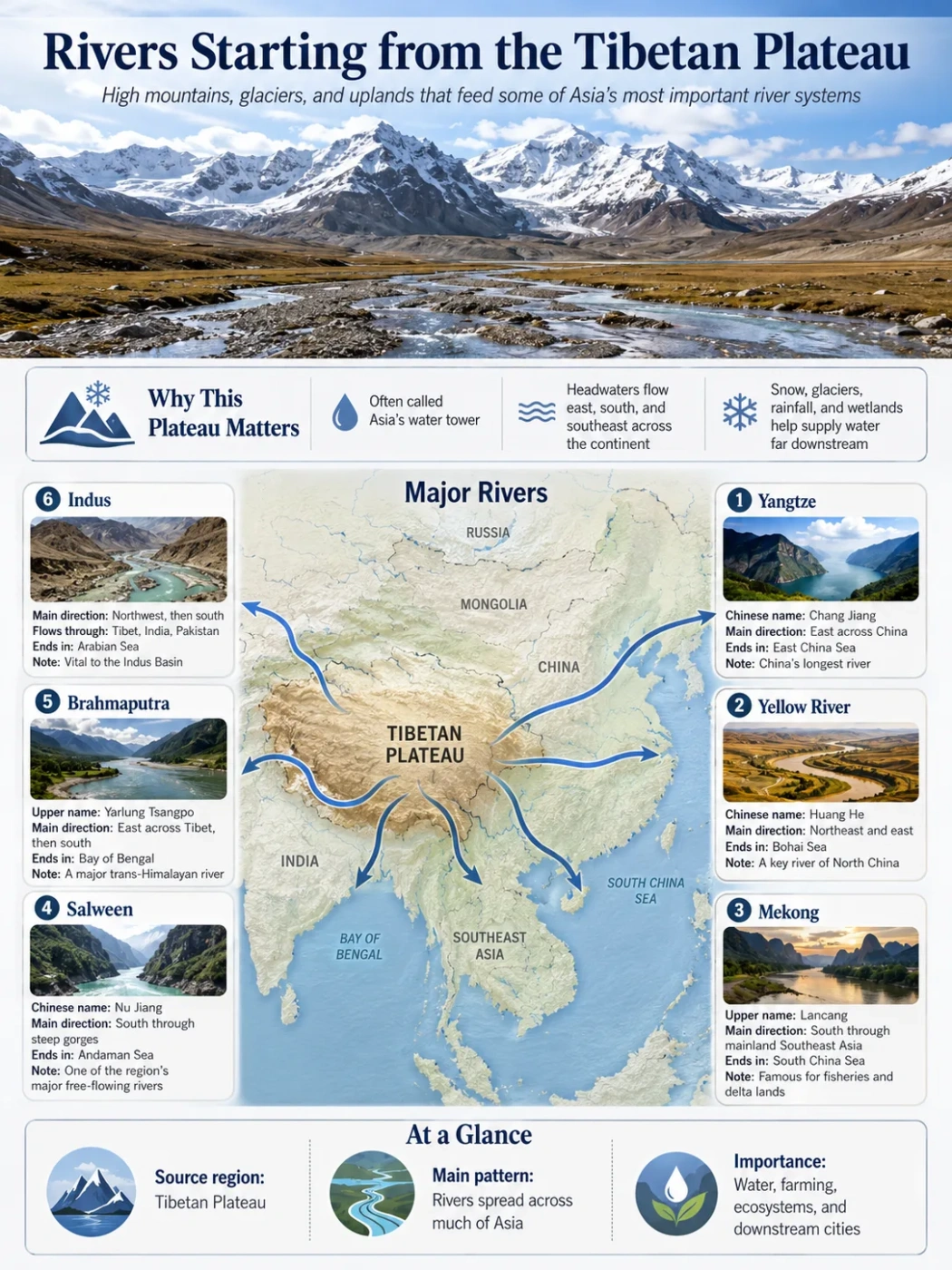
The Yellow River Connects Both Landscapes
The Yellow River begins in the high country of the northeastern Tibetan Plateau. Its upper course crosses high basins, grasslands and gorges before reaching lower terrain. Farther downstream, the river and many of its tributaries drain the Loess Plateau.
- Headwaters: Water gathers among high lakes, wetlands and mountain catchments on the Tibetan Plateau.
- Upper-course incision: The river cuts through uplifted terrain and transports rock-derived sediment eastward.
- Middle-course drainage: Tributaries cross the Loess Plateau and deliver easily eroded silt to the main channel.
- Downstream deposition: As the river reaches lower-gradient plains, part of its sediment load settles within the channel and floodplain system.
Major Loess Plateau tributaries include the Wei, Fen, Wuding, Yan, Jing and Luo rivers. Their basins differ in rainfall, vegetation, loess thickness and degree of gully development.
The contrast is clear: the Tibetan Plateau helps provide the river’s elevation, headwater runoff and upper-basin sediment, while the Loess Plateau strongly affects the sediment load of its middle reaches.
Common Mix-Up
The Yellow River did not deposit the main loess mantle across the plateau. Most loess arrived through the air. Rivers later cut, transported and redeposited part of that wind-blown material.
Lakes, Drainage and Water Storage
The Tibetan Plateau contains thousands of lakes. Many northern and central areas have internal drainage, meaning that streams end in closed basins rather than reaching an ocean. Saline lakes are common where evaporation removes water and leaves dissolved minerals behind. Glaciers, seasonal snow, wetlands and frozen ground also store water.
The Loess Plateau has fewer large natural lakes. Its drainage is more strongly organised around the Yellow River and its tributaries. Water storage often depends on reservoirs, valley dams, check dams, terraces and soil-moisture conservation.
This difference reflects both relief and climate. Closed high basins can hold lakes on the Tibetan Plateau, while the dense valley network of the Loess Plateau moves storm runoff toward larger channels.
Ecology and Human Use
Life on the Tibetan Plateau
Alpine meadow, alpine steppe, cold desert and wetland ecosystems dominate large parts of the plateau. Vegetation height and density respond closely to temperature, moisture, exposure and soil conditions.
Pastoral land use is widespread across open grasslands. Domestic herds can use vegetation that is unsuitable for crops. Agriculture is concentrated in lower and warmer valleys, especially where irrigation and sheltered conditions support barley, wheat and other cold-tolerant crops.
Settlements are unevenly distributed. Broad cold interiors have low population density, while river valleys and eastern or southeastern margins support larger towns and more intensive land use. Roads and railways must cope with high elevation, frozen ground and long distances between service centres.
Life on the Loess Plateau
The Loess Plateau supports extensive farming and a much denser settlement pattern. Deep silt soils are easy to work and can hold plant nutrients, but their productivity depends heavily on moisture control and protection from erosion.
Common land-use adaptations include:
- terracing slopes to slow runoff and create level fields;
- placing crops on gentler land while restoring steep slopes;
- using check dams to trap sediment and reduce channel cutting;
- planting grasses, shrubs or trees where local water conditions allow;
- collecting and managing limited rainfall for farms and settlements.
Loess can also be cut into rooms and courtyards, creating the well-known yaodong settlement form in suitable areas. Modern construction requires careful assessment because wet loess may collapse, settle or fail along steep excavated slopes.
Erosion Works Differently on Each Plateau
Erosion removes material from both regions, but it acts on different surfaces.
On the Tibetan Plateau, glaciers, frost weathering, rivers and slope movement attack bedrock and mountain debris. Along the eastern and southeastern margins, rivers cut deep gorges as water descends from the high interior. The rate of incision depends on rock uplift, faulting, rock strength, runoff and sediment supply.
On the Loess Plateau, water can rapidly cut into loose silt. Sheet wash removes thin surface layers. Rills grow into gullies, while undercut slopes may collapse into channels. Wind erosion is also present, especially in dry and sparsely covered areas, but concentrated water erosion produces many of the plateau’s best-known landforms.
Soil-conservation projects have reduced erosion across many managed watersheds through terracing, vegetation recovery and sediment-control structures. Results vary with slope, rainfall, plant type and available soil water. Dense planting can reduce runoff and soil loss, but vegetation must match the moisture available at each site.
How to Tell the Plateaus Apart on a Map
- Look at elevation first. The Tibetan Plateau appears as a vast area above roughly 4,000 metres. The Loess Plateau occupies a lower step in China’s west-to-east topographic descent.
- Check the mountain setting. The Tibetan Plateau lies among the Himalaya, Karakoram, Kunlun and Qilian systems. The Loess Plateau lies east of the high plateau and around the middle Yellow River.
- Study drainage. The Tibetan interior contains many closed lake basins and major river headwaters. The Loess Plateau shows dense tributary networks flowing toward the Yellow River.
- Examine surface texture. Satellite relief maps show broad high basins and mountain chains in Tibet. The Loess Plateau often displays finely branching gullies and narrow ridges.
- Do not rely on colour alone. Both areas can appear brown or sparsely vegetated in dry-season imagery, even though their elevation, material and climate differ.
Field Note
A high, cold basin with alpine steppe, saline lakes and surrounding snow mountains points toward the Tibetan Plateau. Thick pale silt, near-vertical soil faces, rounded ridges and dense gullies point toward the Loess Plateau.
Tibetan Plateau vs Loess Plateau FAQ
Which is larger, the Tibetan Plateau or the Loess Plateau?
The Tibetan Plateau is larger. Its commonly reported area is about 2.5 million square kilometres, compared with roughly 600,000–650,000 square kilometres for the Loess Plateau. The Tibetan Plateau is therefore close to four times larger under widely used boundary definitions.
Which plateau is higher?
The Tibetan Plateau is much higher. Its average elevation exceeds about 4,500 metres, while the main Loess Plateau commonly lies between roughly 800 and 3,000 metres. Some mountains within or beside the Loess region rise higher than this range, but they do not represent its typical surface.
Are the Tibetan Plateau and Loess Plateau connected?
Yes, but they are separate physiographic regions. The northeastern Tibetan Plateau grades toward mountain systems and basins west of the Loess Plateau. Rivers, wind and sediment transport connect them. The Yellow River begins on the Tibetan Plateau and later drains much of the Loess Plateau.
Did dust from the Tibetan Plateau form the Loess Plateau?
It supplied part of the material. Studies identify the northeastern Tibetan Plateau, Qaidam Basin and Qilian Mountains as important source areas for some Chinese loess. Northern deserts, river sediments and recycled older deposits also contributed. The source mixture changes across the region.
Why is the Loess Plateau called a plateau if it has so many gullies?
The gullies were cut into an older elevated surface and its thick sediment cover. Remnants of broad surfaces remain between valleys, and the region still stands above adjoining lowlands. It is classified as a dissected plateau because erosion has divided much of its former surface.
Is the Tibetan Plateau flat?
No. It contains high plains and broad basins, but also mountain chains, glaciers, valleys, lake depressions and deeply cut margins. “Plateau” describes its broad regional elevation rather than a uniformly level surface.
Does the Yellow River flow across both plateaus?
Its headwaters and part of its upper course lie on the northeastern Tibetan Plateau. The river later enters the Loess Plateau region, where its middle course receives large amounts of sediment from loess-covered tributary basins.
Which plateau has more farmland?
The Loess Plateau has far more extensive cultivated land because most of it is lower and warmer. Farming commonly uses terraces and dryland water-conservation methods. On the Tibetan Plateau, cultivation is concentrated in selected river valleys and sheltered basins, while pastoral land use covers much larger areas.
What is the simplest difference between the two?
The Tibetan Plateau is primarily a tectonically uplifted high plateau. The Loess Plateau is primarily a wind-deposited silt landscape reshaped by erosion. Elevation defines the first most clearly; sediment and gullies define the second.