Northern China Landforms
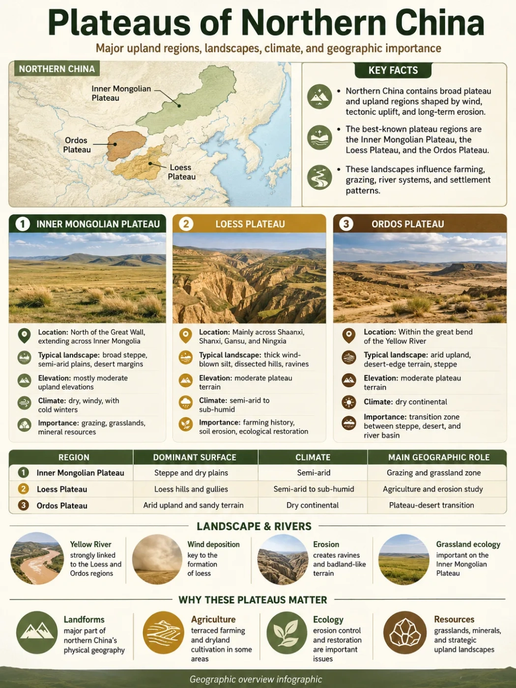
Northern China contains two broad plateau systems: the open steppe and desert surfaces of the Inner Mongolian Plateau and the deeply cut, dust-covered terrain of the Loess Plateau. Their margins meet around Ordos, northern Shaanxi, Shanxi and Bashang.
The plateaus of northern China do not form one continuous, uniform tableland. They include gently rolling grasslands, dry inland basins, dune fields, volcanic surfaces, fault-bounded mountain-and-basin country and loess hills divided by dense networks of gullies.
Scope Note
asin country and loess“Northern China” has no single physical boundary. This inventory covers the named regional plateaus extending from Hulunbuir and the Inner Mongolian borderlands through Bashang and Ordos to the Loess Plateau. It excludes the Tibetan Plateau, the plateaus of Xinjiang and local loess tablelands that are parts of larger regional units.
Inventory of Northern China’s Plateau Regions
The table distinguishes major plateau systems, their named subdivisions and broad overlapping regional labels. Units on different hierarchical levels should not be added together when comparing area.
| Plateau or Region | Geographic Level | Main Location | Elevation | Surface and Origin | Drainage or Basins | Classification Note |
|---|---|---|---|---|---|---|
| Inner Mongolian Plateau | Major plateau system | Inner Mongolia, with adjoining parts of northern Gansu and Ningxia under broader definitions | Mostly about 1,000–2,000 m | Broad structural and erosional plateau with steppe, desert, rocky plains and sedimentary basins | Yellow River margins, Argun–Amur system and many inland basins | Chinese part of the wider Mongolian Plateau; broad definitions include Ordos and Alxa |
| Hulunbuir Plateau | Northeastern subdivision | Western Hulunbuir, Inner Mongolia | Average commonly about 600–800 m; wider study limits about 432–1,662 m | Low, open plateau with meadow steppe, sandy areas, wetlands and lake depressions | Hailar and Argun rivers; Hulun and Buir lakes | Lower than most central and western Inner Mongolian plateau country |
| Xilingol Plateau | Central subdivision | Xilingol League, central Inner Mongolia | About 761–1,927 m; reported mean near 1,104 m | Plateau plains, low hills and shallow mountain belts dominated by temperate steppe | Xilin River and numerous shallow inland basins | Often discussed through its grassland region rather than as a sharply bounded plateau |
| Ulanqab Plateau | South-central subdivision | Ulanqab and adjoining central Inner Mongolia | Often around 1,000–1,500 m; varies across mountain and basin zones | Rolling steppe plateau with basaltic volcanic fields, low mountains and lake basins | Daihai and other inland depressions; drainage toward the Yellow River on some margins | May be spelled Ulan Chab or Wulanchabu in older English references |
| Alxa Plateau | Western subdivision | Western Inner Mongolia and adjoining northern Gansu | Mostly about 1,000–1,500 m; mean often placed near 1,300 m | Dry plateau of low-relief mountains, gravel plains, dune fields and enclosed basins | Terminal reaches of the Heihe and Shiyang systems; many closed basins | Contains the Badain Jaran, Tengger and Ulan Buh desert areas |
| Ordos Plateau | Southwestern plateau and sedimentary basin | Southwestern Inner Mongolia inside the Yellow River’s Ordos Loop | About 1,000–1,500 m | Sedimentary upland with sandy land, dunes, loess-covered margins and a gently raised central divide | Encircled on three sides by the Yellow River; short interior streams and southeastern tributaries | Assigned to both Inner Mongolian and Loess regional schemes because the physical boundaries overlap |
| Bashang Plateau | Southeastern marginal plateau | Northern Hebei, especially Zhangbei, Guyuan, Kangbao, Shangyi, Fengning and Weichang | About 831–2,215 m across a widely used study boundary | Undulating plateau, sandy land, basalt, grassland and shallow basins | Anguli and other inland basins; headwater areas near the plateau margin | A southeastern extension of the Inner Mongolian Plateau above the mountains of northern Hebei |
| Loess Plateau | Major plateau system | Shanxi, Shaanxi, Gansu, Ningxia, western Henan, northeastern Qinghai and southern Inner Mongolia | Broadly about 500 or 800–3,000 m; much of the plateau lies near 1,000–1,500 m | Older bedrock and basins mantled by wind-deposited Quaternary loess, later cut by runoff | Middle Yellow River and tributaries including the Wei, Fen, Luo, Jing, Wuding and Tao | Published areas range from roughly 400,000 to about 649,000 km² because outer boundaries differ |
| Shanxi Plateau | Eastern Loess Plateau sector | Most of Shanxi Province | Much of the province stands near or above 1,000 m | Mountain-and-basin plateau with loess cover, faulted basins and dissected western tablelands | Fen River to the Yellow River; Sanggan, Hutuo and Zhang systems toward the Hai basin | Bounded by the Taihang Mountains toward the North China Plain |
| Northern Shaanxi Plateau | Central Loess Plateau sector | Yan’an and Yulin areas of northern Shaanxi | Commonly about 1,000–1,500 m | Loess ridges, hills, remnant tablelands, gullies and sandy transition zones | Wuding, Yan and Luo rivers within the Yellow River basin | A regional subdivision rather than a separate geological block |
| Longzhong Plateau | Western Loess Plateau sector | Central and eastern Gansu | No single range fits every published boundary; much lies above 1,500 m | High loess hills, ridges, tablelands and river-cut valleys | Tao, Wei and upper Yellow River systems | Also called the Central Gansu Plateau in broad English-language divisions |
| Shaanxi–Gansu Plateau | Broad overlapping regional label | Shaanxi and eastern or central Gansu, with boundaries varying by classification | Varies by definition | Loess-covered uplands, tablelands and dissected hill country | Wei, Jing, Luo and other Yellow River tributaries | Overlaps the Northern Shaanxi and Longzhong sectors; it is not an additional parallel plateau |
Map Note
A single map pin cannot represent these plateaus. They form a wide belt from the Russian and Mongolian borderlands to the Qinling Mountains. On a relief map, look west of the Greater Hinggan and Taihang mountain fronts and north of the Qinling range.
Two Plateau Belts with Different Surfaces
The Open Plateaus of Inner Mongolia
The Inner Mongolian Plateau belongs to the wider Mongolian Plateau of East and Central Asia. Much of its surface is broad and gently rolling rather than sharply mountainous. Low ranges, volcanic fields and enclosed basins interrupt the open terrain.
Its eastern and central sections support meadow steppe, typical steppe and desert steppe. Farther west, rainfall declines and grassland gives way to gravel-covered gobi, sparse desert vegetation and large dune fields.
The plateau does not have one drainage pattern. Hulunbuir connects partly with the Argun–Amur river system. Ordos touches the Yellow River. Xilingol, Ulanqab and Alxa contain many rivers that end in shallow lakes, salt depressions or dry basins without reaching the sea.
The Dust-Mantled Loess Plateau
The Loess Plateau is defined by its cover of wind-deposited silt. Repeated dust accumulation during the Quaternary blanketed older rock surfaces, river terraces, basins and mountain foothills. Loess commonly reaches tens of metres in thickness and becomes much thicker in some central and western areas.
This surface looks smooth where broad remnants remain, but concentrated summer rain can cut quickly into the porous sediment. The result is a dense pattern of branching gullies, narrow ridges, steep-sided valleys and isolated loess tablelands.
The plateau slopes broadly from the higher northwest toward the lower southeast. Rivers crossing this gradient carry fine sediment into the Yellow River system. The same process that creates deeply dissected terrain also links the plateau to floodplains and deltas farther downstream.
Ordos as the Geographic Hinge
The Ordos Plateau sits between the two systems. Its northern surface includes the Kubuqi Desert and Mu Us sandy land, which fit the dry Inner Mongolian landscape. Its southern and southeastern margins merge into loess-covered northern Shaanxi.
Geologically, the larger Ordos region is also described as a sedimentary basin or stable crustal block. “Ordos Plateau,” “Ordos Basin” and “Ordos Block” therefore refer to related but different ideas: surface landform, subsurface sedimentary basin and tectonic unit.
Common Mix-Up
The Hetao Plain is not a plateau. It is a low alluvial and irrigated plain beside the Yellow River, bordered by higher plateau and mountain terrain. Its presence inside a broad Inner Mongolian plateau region does not change its landform classification.
How Northern China’s Plateau Surfaces Developed
No single event formed every northern Chinese plateau. Their present relief records several stages of crustal movement, sediment accumulation and erosion.
Old Crust and Sedimentary Basins
Ancient continental crust, including the North China Craton, provided the deep foundation. Broad basins such as Ordos accumulated thick sequences of sediment over long periods.
Uplift, Faulting and Basin Formation
Regional crustal movement raised broad surfaces and produced fault-bounded depressions. The Shanxi basin chain and the margins of the Ordos Block show this structural control.
Wind Added Loess and Sand
Cold, dry periods supplied dust and sand from northern and northwestern source areas. Fine silt accumulated across the Loess Plateau while coarser sand formed dune fields and sandy lands farther north.
Water and Wind Reworked the Surface
Summer runoff cut gullies into loess. Wind shifted exposed sand, rivers built terraces and plains, and closed basins collected lake, salt and alluvial deposits.
Mountains and Escarpments That Define the Plateau Margins
Northern China’s plateaus are easier to locate by their surrounding mountain fronts than by provincial borders.
- Greater Hinggan Mountains: form a major eastern relief break between the Inner Mongolian highlands and the lower plains of northeastern China.
- Yin Mountains: cross central Inner Mongolia and separate parts of the northern plateau from the Yellow River and Hetao Plain.
- Helan Mountains: divide the Alxa desert country from the Yellow River corridor and the western side of Ordos.
- Taihang Mountains: create the steep eastern edge of the Shanxi and Loess plateau country above the North China Plain.
- Lüliang Mountains: separate the Fen River basin from the Yellow River gorge along western Shanxi.
- Liupan Mountains: mark a climatic and topographic transition within the western Loess Plateau.
- Qinling Mountains: form the southern boundary of the main Loess Plateau and a major divide between northern and southern river systems.
Bashang occupies a different kind of edge. It stands above northern Hebei, where travelers moving northwest from the lower Beijing–Tianjin–Hebei region cross mountain passes and reach the higher Inner Mongolian surface.
Three Drainage Worlds
Northeastern Drainage
Argun and Amur Basin
Hulunbuir contains the Hailar and Argun river system, wetlands and large lakes. It has more surface water than the dry plateaus farther west.
Interior Drainage
Closed Lakes and Dry Basins
Parts of Xilingol, Ulanqab and Alxa drain into inland depressions. Water may end in a lake, salt flat, wetland or desert basin.
External Drainage
The Yellow River Basin
Ordos is wrapped by the Yellow River, while the Loess Plateau is cut by its middle course and many sediment-bearing tributaries.
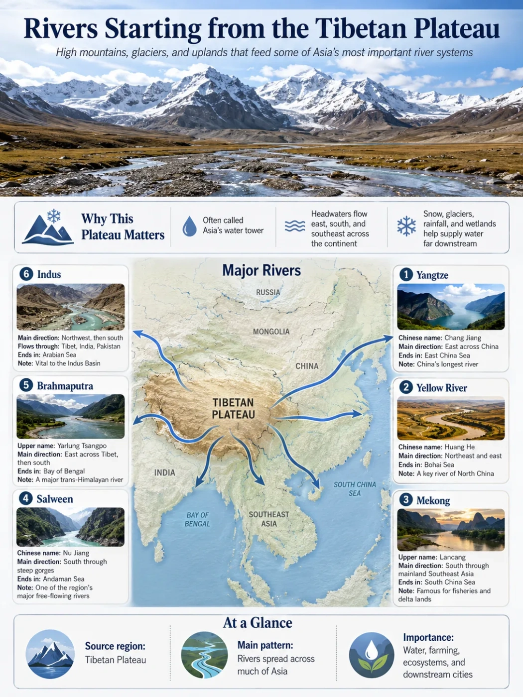
The Yellow River does not originate on these northern plateaus. Its headwaters lie on the Tibetan Plateau. It enters northern China from the west, crosses the Ningxia corridor, bends around Ordos and then turns south between Shaanxi and Shanxi.
Tributaries flowing across loess terrain carry easily detached silt. The river therefore links plateau erosion with sediment deposition in downstream valleys, the North China Plain and the Bohai coastal region.
Drainage boundaries do not always follow plateau names. A single named plateau may contain both sea-connected and internal drainage. Local mountain ridges, faults, dunes and shallow depressions determine where water actually flows.
Climate from Hulunbuir to Alxa
The northern plateau belt has a strongly continental climate. Winters are cold and dry, spring is often windy, and most annual precipitation falls during the warmer months. Elevation adds cooler conditions, but distance from moisture sources creates the clearest regional contrast.
A Broad East-to-West Drying Pattern
Hulunbuir can receive roughly 350–500 mm of annual precipitation in the plateau study areas commonly used by researchers. Xilingol and Ulanqab occupy drier steppe zones, though totals vary with elevation and location. Ordos ranges from roughly 450 mm in the southeast to about 150 mm in the northwest.
Alxa is much drier. Some desert sectors receive less than 100 mm in an average year, while potential evaporation is many times greater. This gradient helps explain the change from meadow steppe through typical and desert steppe to dune desert and gravel plain.
The Loess Plateau’s Southeast–Northwest Contrast
Across the Loess Plateau, annual precipitation generally rises toward the southeast and declines toward the northwest. Published regional ranges commonly extend from about 200 to 700 mm, although wider study boundaries produce lower or higher endpoints.
Rainfall is strongly seasonal. Short summer storms can produce rapid runoff on steep slopes and exposed loess. A modest annual total can therefore cause intense erosion when much of it arrives during a small number of storms.
Landforms within the Plateau Belt
Loess Tablelands, Ridges and Hills
Broad, relatively level loess remnants are often called yuan. Smaller elongated ridges and rounded loess hills are traditionally distinguished as different forms. Continued river incision divides large surfaces into progressively narrower ridges and isolated remnants.
Dongzhi and Luochuan are examples of named loess tableland areas within the larger plateau. They are local geomorphic surfaces rather than separate regional plateaus on the same level as the Loess Plateau.
Deserts on Elevated Ground
A desert can occupy a plateau. The Badain Jaran, Tengger, Ulan Buh and Kubuqi deserts lie on elevated or basin-filled terrain within the northern plateau belt. Their dunes are surface deposits and do not define the deep geological structure beneath them.
The Mu Us region is often called a sandy land rather than a true dune desert because vegetation, soils and fixed or partly fixed sand cover much of its surface. It marks a transition between Ordos grassland, desert terrain and the northern Loess Plateau.
Volcanic Terrain in Ulanqab
Ulanqab includes young-looking volcanic cones, lava surfaces and crater forms rising above the plateau. These features record episodes of basaltic volcanism, but they do not mean the whole Inner Mongolian Plateau is a single volcanic plateau. Much of the surrounding surface has a different structural and erosional origin.
Basins inside the Shanxi Plateau
The Shanxi Plateau contains a north–south chain of basins and valleys, including Datong, Xinzhou, Taiyuan, Linfen and Yuncheng. Faulting helped create this lower corridor between mountain belts.
This arrangement explains why a plateau province can contain broad agricultural lowlands and densely settled transport routes. Plateau classification describes the regional elevation and relief, not an uninterrupted flat surface.
Grassland, Farming and Settlement
Land use follows moisture, soil depth, slope and access to water. The eastern Inner Mongolian plateaus support broad grazing landscapes. Cultivation becomes more common along river valleys, around settled basins and across the farming–pastoral transition in Ulanqab, Bashang and southeastern Ordos.
Loess can hold nutrients and is easy to work, so flatter tablelands and gentle slopes have long supported dryland farming. Millet, maize, wheat, potatoes and other crops vary with local temperature and rainfall. Terraces allow cultivation on some slopes while reducing the speed of runoff.
Major settlements tend to occupy basins, river terraces and alluvial corridors rather than the driest or most dissected surfaces. Taiyuan lies in the Fen River basin. Hohhot and Baotou sit near the southern plateau margin and Yellow River corridor. Many smaller Loess Plateau settlements occupy valley floors or the edges of tablelands.
Transport routes also favor basin chains and river corridors. Deep gullies fragment parts of northern Shaanxi and western Shanxi, while open steppe surfaces allow long overland routes but provide fewer dependable water sources.
Reading Northern China on a Relief Map
- Locate the North China Plain, the broad lowland extending inland from the Bohai coast.
- Follow the Taihang mountain front westward and upward into the Shanxi and Loess plateau country.
- Trace the Yellow River’s large northern loop around Ordos.
- Look north of the Yin Mountains for the open central Inner Mongolian Plateau.
- Follow that plateau east toward Xilingol and the lower Hulunbuir surface.
- Move west of the Helan Mountains to reach the dry Alxa Plateau and its enclosed desert basins.
Landform Note
The North China Plain, Northeast China Plain, Hetao Plain and individual river basins should not be counted as plateaus simply because they lie within or beside a highland region. Relative relief, surface form and geological setting matter more than the regional name alone.
Frequently Asked Questions
What are the two main plateaus of northern China?
The two main systems are the Inner Mongolian Plateau and the Loess Plateau. Ordos lies in their transition zone, while Bashang forms a southeastern margin of the Inner Mongolian surface.
Which is the highest plateau in northern China?
No single northern plateau is uniformly highest. The Loess Plateau reaches higher mountain and western upland areas, with some study boundaries extending to about 3,000 m. Most Inner Mongolian plateau surfaces lie between roughly 1,000 and 2,000 m, although Hulunbuir is lower.
Is the Mongolian Plateau the same as the Inner Mongolian Plateau?
No. The Mongolian Plateau is an international physical region extending across Mongolia and parts of China and Russia. The Inner Mongolian Plateau is its Chinese portion under the usual narrow definition, although broader Chinese classifications extend it into Ordos and Alxa.
Why is the Loess Plateau so deeply cut by gullies?
Its porous, fine-grained loess is easily detached by runoff. Seasonal rain flowing down slopes cuts channels that expand into branching gullies and valleys. Sparse cover and cultivation on steep slopes can speed up this process.
Is the Ordos Plateau part of the Loess Plateau?
It depends on the boundary system. Northern Ordos is commonly associated with the Inner Mongolian Plateau, while southern Ordos merges into loess-covered northern Shaanxi. Some Loess Plateau studies include Ordos as a regional landform unit.
Are the deserts of northern China lowlands?
Not necessarily. The Badain Jaran, Tengger, Kubuqi and parts of the Mu Us sandy region occupy elevated plateau or basin surfaces. Desert describes climate and surface cover; it does not specify elevation.
Which northern plateau is closest to Beijing?
The Bashang Plateau in northern Hebei is the nearest named plateau region. It lies northwest and north of Beijing beyond the mountain belts of northern Hebei and forms part of the transition to the Inner Mongolian Plateau.
Does the Yellow River begin on the Loess Plateau?
No. The Yellow River begins on the Tibetan Plateau. It later crosses northern China, bends around Ordos and cuts along or through the Loess Plateau, where it receives large amounts of fine sediment from tributaries.