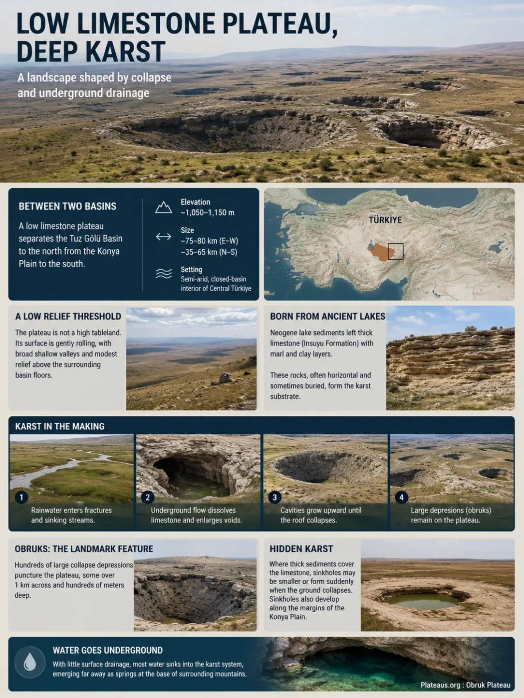
Obruk Plateau is a low limestone plateau in Central Türkiye, positioned between the Tuz Gölü basin and the Konya Plain. Much of its surface lies around 1,100 meters and appears gently rolling rather than mountainous, yet the ground contains one of Central Anatolia’s most distinctive karst systems. Large collapse depressions known locally as obruks expose a landscape controlled as much by groundwater, fractures and buried cavities as by processes visible at the surface.
Deep karst and collapse depressions
Semi-arid closed-basin setting
Between the Tuz Gölü Basin and the Konya Plain
Obruk Plateau occupies an intermediate rise within the wider Konya Closed Basin of Central Anatolia. The Tuz Gölü depression lies to the north, while the Konya Plain and the Karapınar sector extend to the south and southeast. The plateau therefore functions as a broad geomorphic threshold between two internally drained lowlands rather than as a high mountain block.
Published descriptions commonly give an east-west length of roughly 75–80 kilometers and a north-south width that varies from about 35 to 65 kilometers. Elevation also depends on where the plateau boundary is drawn. Much of the surface is described between about 1,050 and 1,150 meters, with around 1,100 meters providing a useful general reference.
Lower northern closed-basin terrain containing Türkiye’s major salt-lake depression.
A limestone threshold where large karst depressions and underground drainage are concentrated.
Broad southern lowland with thick basin sediments and extensive agricultural groundwater use.
Boundary Note
Obruk Plateau is a physical-geography region rather than a sharply surveyed administrative unit. Its dimensions and quoted elevation range vary slightly among geomorphological studies depending on which margins and neighboring plains are included.
A Plateau Defined More by Position Than by Height
Obruk Plateau does not resemble a high tableland bordered everywhere by cliffs. Most margins are gradual, and the upper surface is a subdued mixture of shallow depressions, broad low rises and gently rolling ground. Relative elevation above the neighboring Konya Plain is modest.
This low relief is important to its classification. The plateau remains a raised regional surface separating lower basin floors even though its top is neither uniformly flat nor dramatically elevated. Its most conspicuous relief comes from features cut downward into the plateau: deep karst depressions rather than mountain peaks.
Broad shallow valleys also cross parts of the plateau, many with little or no permanent flow under the present semi-arid climate. Some are interpreted as inherited drainage features developed during wetter phases of the Quaternary, when runoff across Central Anatolia was stronger than it is today.
Lake-Bed Limestone Created the Karst Substrate
The plateau’s karst geography begins with its sedimentary history. Much of the region is underlain by Neogene lacustrine carbonate rocks, especially limestone of the Insuyu Formation. These rocks accumulated in ancient lake environments that occupied parts of the Central Anatolian interior before the modern dryland landscape developed.
The limestone is commonly close to horizontal and occurs with marl, clay-rich beds and other sedimentary layers. Older carbonate rocks also occur deeper in the geological succession. In some sectors, younger alluvial and lake sediments cover the limestone and conceal the cavities below.
This arrangement matters because karst does not require the entire landscape to consist of bare limestone. Water can enter fractures, move through carbonate units at depth, dissolve rock and create voids even where the surface is mantled by soil or basin sediment.
Why the Rock Sequence Matters
Exposed limestone favors recognizable bedrock karst on the plateau, while thick unconsolidated sediment over buried limestone produces a different failure style. This difference helps explain why the old giant obruks of the plateau and many younger sinkholes on the Karapınar-Hotamış Plain do not look the same.
The Karst System Extends Far Below the Dry Surface
Ordinary surface karst develops when rainwater absorbs carbon dioxide, becomes weakly acidic and moves downward through joints in soluble rock. That process occurs in many limestone regions, but research on the Konya Closed Basin indicates that the largest obruks cannot be explained adequately by shallow dissolution alone.
The plateau is associated with deep or hypogene karstification. In this type of system, chemically aggressive groundwater can move upward or laterally through fractures from deeper parts of the rock sequence. Faults provide preferred pathways, while gases associated with the region’s volcanic and tectonic history can increase the ability of groundwater to dissolve carbonate rock.
Over long periods, dissolution enlarges fractures and buried openings. Cavities can become far larger than anything visible at the surface. A collapse obruk forms only when the material above one of these voids can no longer remain stable.
Joints and faults provide routes through otherwise solid carbonate rock.
Groundwater dissolves limestone along preferred pathways and gradually creates larger voids.
The underground opening expands while the surface may remain almost unchanged.
Rock or sediment above the cavity loses support as the void enlarges or groundwater conditions change.
Failure produces a closed depression that may be steep-sided, cylindrical, bowl-shaped or later softened by erosion.
Faults Help Explain Why Obruks Cluster Instead of Appearing Randomly
The distribution of obruks is not uniform across the plateau or the wider basin. Geological studies have repeatedly found alignments and clusters associated with structural zones. Recent basin-scale work strengthens this interpretation by showing that many younger sinkholes occur close to faults rather than being scattered randomly through agricultural land.
Faults matter because fractured rock has more pathways for water and gas movement. Where those pathways intersect soluble carbonate units, dissolution can be concentrated into narrow corridors. The resulting cavities may remain hidden until a later change in groundwater level or overburden stability allows collapse to propagate upward.
This also explains why mapping only surface geology can miss part of the hazard. A field may appear to consist of ordinary soil or lake sediment even though fault-controlled karst voids exist in limestone below it.
Why Some Obruks Contain Lakes and Others Are Dry
An obruk does not automatically become a lake. The decisive relationship is between the floor of the depression and the local groundwater table. If collapse extends below groundwater level, water can occupy the lower part of the depression. If the floor remains above the water table, or if groundwater later falls below it, the obruk may remain dry.
This is why neighboring obruks can have very different appearances even when they developed within the same regional karst system. Water-filled obruks provide unusually direct views of groundwater that normally remains hidden below the Central Anatolian steppe.
Groundwater Window
Kızören Obruğu
Kızören is a large water-filled collapse depression in the northern part of the plateau. Its lake exposes the groundwater system directly at the surface. The obruk and its surroundings form a 127-hectare Ramsar Site, an unusual wetland setting within an otherwise dry steppe landscape.
Mature Karst Depression
Meyil Obruğu
Meyil is one of the plateau’s broad old obruks and contains a lake within a large elliptical depression. Recent research has documented declining lake extent as well as circular fractures around parts of the feature, linking its present condition to continuing changes in the groundwater system.
Exposed Collapse Walls
Çıralı Obruğu
Çıralı shows the scale of an old bedrock collapse particularly clearly. Steep walls expose the limestone sequence above a lake whose level has fallen over time. Cavities visible in parts of the walls include both natural openings and old human-modified spaces.
Old Giant Obruks and Recent Sinkholes Are Not the Same Landform Population
The word obruk is now widely used for sinkholes across the Konya region, but two contrasting groups need to be separated. The classic features that gave Obruk Plateau its name are old, often very large collapse depressions developed in or through carbonate bedrock. Many newer failures occur farther south and southeast beneath younger basin sediments around Karapınar and the Hotamış Plain.
Older Plateau Obruks
- Concentrated strongly on the limestone plateau.
- Include giant bedrock and caprock collapse depressions.
- Can reach several hundred meters across.
- Many have weathered or degraded rims that record long landscape evolution.
- Some intersect groundwater and contain persistent or changing lakes.
- Their development is linked to long-lived deep karstification.
Recent Cover-Collapse Sinkholes
- Common in sediment-covered sectors of the wider Konya Basin.
- Frequently affect agricultural land around Karapınar and Hotamış.
- Often begin as sharper and smaller collapse openings.
- Develop where unstable cover overlies cavities in carbonate rock.
- Show strong spatial relationships with fault-controlled karst zones.
- Modern groundwater decline can increase the likelihood of collapse.
Common Landform Mix-Up
Not every circular depression near Karapınar is an obruk. Meke Maar and nearby volcanic crater landforms originated through volcanism rather than limestone dissolution and karst collapse. Their circular outlines can look similar on maps or satellite imagery, but their geological origins are different.
Groundwater Decline Can Trigger Collapse Without Creating the Karst System
Irrigation has placed heavy pressure on groundwater across the Konya Closed Basin. As pumping lowers hydraulic head, saturated cavities can drain, sediment can migrate into openings, and changes in pore-water pressure can reduce support for material above pre-existing voids. These processes can make collapse more likely.
Groundwater withdrawal should therefore be understood as a trigger or accelerating influence within an older karst system, not as the origin of that system. The cavities, fault-controlled dissolution zones and carbonate aquifers developed over geological timescales. Modern water use changes the conditions under which some of those cavities remain stable.
A basin-wide study published in 2026 mapped the timing of hundreds of cover-collapse sinkholes through August 2024. The results show that collapse frequency did not simply rise at a constant rate.
| Period | Sinkholes Formed in the Inventory | Average Frequency |
|---|---|---|
| 2000–2010 | 36 | 3.3 per year |
| 2011–2015 | 88 | 17.6 per year |
| 2016–2019 | 128 | 32.0 per year |
| 2020–August 2024 | 104 | 22.3 per year |
The decline after the 2016–2019 peak does not indicate that the regional groundwater problem has been solved. The study found continued water-table decline and interpreted the lower recent collapse frequency partly as possible progressive exhaustion of the most collapse-prone pre-existing cavities. In other words, sinkhole hazard can change through time even while groundwater stress continues.
A Basin Count Is Not an Obruk Plateau Count
An AFAD inventory reported 739 recorded sinkholes across the Konya Closed Basin in August 2026. That figure covers a much larger area across Konya, Karaman and Aksaray and includes several types and generations of sinkholes. It should not be described as 739 obruks on Obruk Plateau itself.
A Dry Steppe Surface Above an Active Groundwater System
Obruk Plateau lies in a semi-arid continental environment. Summers are dry, winters are cold, and precipitation is low compared with potential evaporation. Steppe vegetation dominates much of the open ground, while permanent surface streams are limited.
The apparent dryness can be misleading from a hydrological perspective. Water entering the wider Konya Basin from precipitation and mountain recharge can move through carbonate aquifers beneath the plains and plateau. The subsurface drainage network is therefore more developed than the surface stream pattern suggests.
This contrast has direct consequences for land use. Rain-fed cereal cultivation and grazing suit much of the plateau surface, while irrigated agriculture becomes more important across surrounding lowlands. Where irrigation depends heavily on wells, the agricultural landscape and the karst groundwater system become physically connected.
Steppe, dry fields, shallow valleys and limited permanent runoff.
Soil, lake sediment, weathered carbonate and fractures carrying infiltrated water.
Groundwater moving through fractured and dissolved carbonate rock.
Faults and dissolution zones that can localize large cavities and eventual collapse.
Obruk Plateau Sits Inside a Much Larger Closed-Basin System
Several geographic names used in discussions of Central Türkiye sinkholes describe different spatial scales. Keeping them separate is necessary when interpreting maps, sinkhole counts and groundwater studies.
| Geographic Name | What It Refers To | Relationship to Obruks |
|---|---|---|
| Obruk Plateau | A specific limestone plateau and intermediate rise between major basin lowlands. | Contains the classic concentration of large old obruks that gave the plateau its name. |
| Konya Closed Basin | A much larger endorheic drainage basin of roughly 50,000 km² in Central Anatolia. | Contains Obruk Plateau as well as plains, volcanic terrain and numerous modern sinkhole zones. |
| Konya Plain | A broad low-relief basin floor south of the plateau. | Contains thick lacustrine and alluvial deposits above parts of the regional carbonate system. |
| Karapınar-Hotamış Plain | A sediment-covered lowland southeast of the main old-obruk concentration. | One of the principal areas where younger cover-collapse sinkholes have developed in agricultural fields. |
| Tuz Gölü Basin | The lower closed-basin terrain north of Obruk Plateau surrounding Tuz Gölü. | Forms the northern side of the regional groundwater and topographic setting in which the plateau developed. |
Landform Terminology
Obruk is a Turkish term applied to collapse depressions and has become established in scientific descriptions of Central Anatolian karst. On Obruk Plateau it refers most characteristically to large collapse dolines or sinkholes produced by the failure of rock above deeply developed karst cavities.