INTERACTIVE CONTEXT MAP
Where is Central Anatolian Plateau?
The selected plateau and nearby mapped locations are shown. Open the full world atlas to explore every region.
Turkey’s Interior Plateau Region
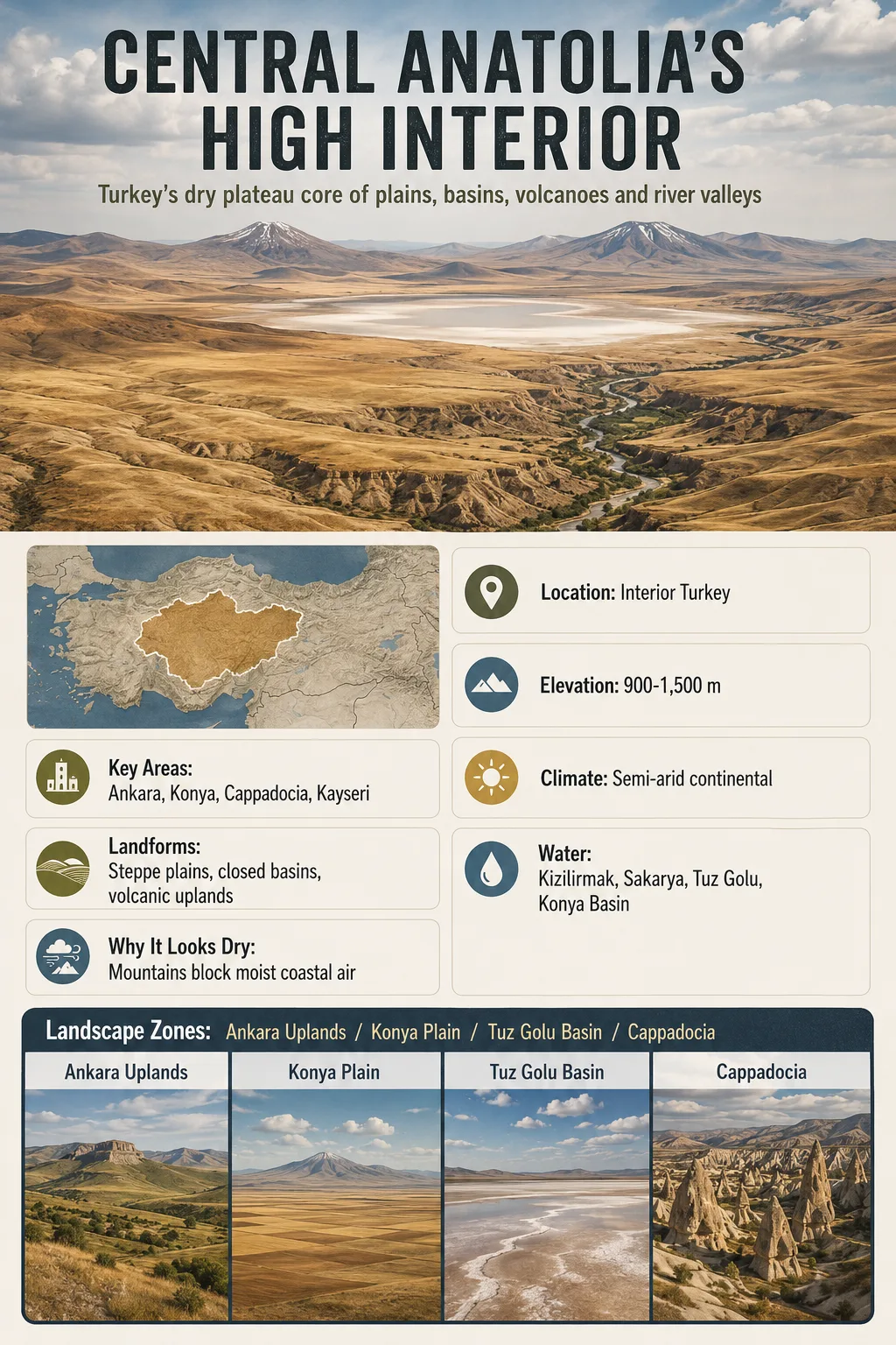
The Central Anatolian Plateau is the broad, high interior of Turkey, where dry basins, steppe plains, volcanic mountains and river valleys form one of the clearest plateau landscapes in Anatolia.
The Central Anatolian Plateau sits away from Turkey’s humid coasts. It is not a flat table in the simple sense. It is a high interior landform made of rolling plains, enclosed basins, volcanic uplands, salt flats, river trenches and scattered mountain masses.
This region helps explain why central Turkey feels so different from the Black Sea coast, the Mediterranean shore or the eastern highlands. Distance from the sea, surrounding mountain belts and high elevation give the plateau a dry climate, cold winters, hot summers and wide open steppe landscapes.
| Feature | Central Anatolian Plateau Profile |
|---|---|
| Location | Interior Turkey, mainly within the Central Anatolia Region |
| Major Cities and Areas | Ankara, Konya, Kayseri, Aksaray, Nevsehir, Kirsehir and parts of Sivas |
| Typical Elevation | Roughly 900-1,500 m, with higher volcanic and mountain areas rising above the plateau surface |
| Landform Type | Interior high plateau with basins, steppe plains, volcanic uplands and dissected river valleys |
| Climate | Semi-arid to dry continental; colder and drier than Turkey’s coastal regions |
| Main Drainage Features | Kizilirmak, Sakarya, closed basins around Tuz Golu and the Konya Basin |
| Known For | Steppe landscapes, Cappadocia volcanic terrain, salt lakes, cereal farming and enclosed basins |
Map Note
The map shows the general interior region of Central Anatolia. It should be used for orientation, not as a precise scientific boundary for the plateau, because the plateau grades into nearby mountains, basins and volcanic uplands.
Regional Setting and Boundaries of the Central Anatolian Plateau
The Central Anatolian Plateau lies in the middle of Turkey, between the Pontic Mountains to the north and the Taurus Mountains to the south. These mountain belts help isolate the interior from moist maritime air.
The plateau includes much of the land around Ankara and Konya, then extends eastward toward Kayseri, Nevsehir and Sivas. Its limits are not always drawn the same way. Some descriptions use the administrative Central Anatolia Region, while others focus on the higher geomorphic plateau surface inside that region.
Geography Note
Central Anatolia is both a geographic region and a plateau landscape. The two overlap strongly, but they are not identical. Administrative borders are sharper than natural landform boundaries.
Regional Edges
To the west, the plateau lowers toward western Anatolia and the Sakarya drainage. To the south, it meets the Taurus margin and the Konya Basin. To the east, it rises toward the higher and more rugged interior of eastern Anatolia.
This position gives the plateau its main geographic character: it is an inland high surface surrounded by stronger relief.
Elevation and Surface Shape
The plateau is commonly described as standing around 900 to 1,500 meters above sea level. Some basins and plains sit lower, while volcanic peaks and mountain blocks rise much higher.
Konya Plain, Ankara’s surrounding uplands and the Cappadocian volcanic terrain all belong to the broader central plateau setting, but they do not look the same on the ground. The region shifts between open plains, low hills, eroded valleys and volcanic cones.
Interior Plains
Wide Steppe Surfaces
Large areas around Konya, Ankara and Aksaray are open, dry and gently rolling, with broad agricultural fields and sparse natural tree cover.
Volcanic Uplands
Cappadocia and Kayseri
Volcanic rocks, ash deposits and cones shape parts of Cappadocia and the Kayseri area, including terrain linked to Erciyes and Hasan mountains.
Closed Basins
Salt Lakes and Dry Floors
Some interior basins drain inward rather than to the sea, creating salt flats, seasonal wetlands and dry lake margins.
Elevation Note
Elevation values vary by source because the plateau has no single hard edge. A city, basin floor, volcanic cone and mountain shoulder can all sit within the same regional plateau setting but at very different heights.
Why the Plateau Is Dry and Continental
The Central Anatolian Plateau has a semi-arid continental climate. Summers are generally hot and dry. Winters are cold, with frost and snow more common than in Turkey’s coastal lowlands.
The main reason is geography. Moist air from the Black Sea and Mediterranean loses much of its influence before reaching the interior. The surrounding mountain belts create a rain-shadow effect, while elevation lowers winter temperatures.
| Climate Feature | How It Appears on the Plateau |
|---|---|
| Rainfall | Generally low to moderate, often decreasing toward interior basins such as Konya and Tuz Golu |
| Summer | Dry, sunny and warm to hot, with strong evaporation from open land and lake margins |
| Winter | Cold compared with coastal Turkey; snow and hard frost can occur across high interior areas |
| Vegetation | Steppe grasses, dry farming landscapes, patches of woodland on wetter or higher ground |
| Agricultural Pattern | Cereals, pulses, sugar beet and irrigated crops where water is available |
The result is a landscape where water availability matters more than elevation alone. A short distance can separate irrigated fields from dry steppe, salt flats or eroded volcanic slopes.
Rivers, Lakes and Interior Basins
Central Anatolia is not one simple drainage system. Some rivers cut outward toward surrounding seas, while other waters collect in closed basins inside the plateau.
The Kizilirmak, the longest river flowing entirely within Turkey, makes a wide arc through central and northern Anatolia before reaching the Black Sea. The Sakarya River also drains parts of the plateau toward the northwest. These rivers show that the plateau is high enough to feed outward-flowing drainage, but broad enough to contain internal basins too.
Tuz Golu and the Konya Basin
Tuz Golu, one of Turkey’s best-known salt lakes, lies in a closed interior basin. Water that reaches this area may evaporate rather than flow to the sea, leaving salts behind. The Konya Basin works in a similar broad interior setting, with dry plains, seasonal water bodies and heavy dependence on groundwater and irrigation.
2026 Konya Closed Basin Sinkhole Update
August 11, 2026: AFAD’s updated sinkhole inventory recorded 739 sinkholes across Konya, Karaman and Aksaray. The Obruk Duyarlılık Haritası project uses GIS, satellite imagery and artificial intelligence to update the regional inventory and map areas susceptible to collapse.
A January 2026 Engineering Geology study of the Konya Basin found that sinkholes cluster along fault zones associated with deep karstification. Intensive groundwater withdrawal can also reactivate pre-existing underground cavities. Sinkhole development therefore reflects the combined effects of geologic structure, karst processes, groundwater conditions and pumping, rather than drought alone.
Geology and Landform Formation
The Central Anatolian Plateau formed within the wider tectonic setting of Anatolia, where the region has been shaped by collision, faulting, uplift, volcanism and erosion. It is not only an old flat surface lifted upward. It is a layered landscape with several processes working together.
Tectonic Uplift Raises the Interior
Long-term plate movement and regional uplift helped raise central Anatolia above nearby lowlands and seas.
Basins Form Between Higher Blocks
As the land rose and faulted, interior depressions such as the Konya Basin and Tuz Golu basin became important parts of the plateau surface.
Volcanic Activity Adds New Terrain
Volcanoes and ash deposits shaped parts of Cappadocia, Kayseri and nearby uplands, creating tuff, cones and eroded volcanic forms.
Rivers and Weathering Cut the Surface
Rivers, wind, frost and seasonal runoff dissected softer rocks and exposed harder layers, especially in volcanic and basin-margin landscapes.
Cappadocia is the clearest example of this mixed origin. Its famous valleys and rock forms developed from volcanic deposits that were later carved by erosion. Nearby high volcanic mountains, including Erciyes and Hasan, stand above the broader plateau surface.
Main Landscape Zones Within the Plateau
The Central Anatolian Plateau is easier to understand when read as a group of connected landscape zones rather than one uniform landform.
| Landscape Zone | General Location | Main Features | Geographic Role |
|---|---|---|---|
| Ankara Uplands | Northwestern Central Anatolia | Rolling plateau surfaces, river valleys, dry farming areas | Connects the interior plateau with western Anatolia and the Sakarya drainage |
| Konya Plain and Basin | South-central interior | Broad dry plains, enclosed drainage, irrigated agriculture | One of the clearest closed-basin landscapes of central Turkey |
| Tuz Golu Basin | Between Ankara, Aksaray and Konya | Salt lake, flat basin floor, dry margins | Shows the arid interior drainage pattern of the plateau |
| Cappadocian Volcanic Area | Nevsehir, Kayseri, Aksaray and nearby areas | Tuff, volcanic cones, eroded valleys, high volcanic peaks | Adds volcanic relief and soft-rock erosion forms to the plateau |
| Sivas and Eastern Margins | East-central Turkey | Higher, more dissected plateau and upland terrain | Forms a transition toward the higher eastern Anatolian landscape |
Climate, Farming and Settlement
The plateau has long supported towns, roads and farming because it offers broad land surfaces and interior routes. Yet its dry climate limits what can grow without careful water use.
Cereal farming is common across the open steppe plains. Wheat and barley fit the climate better than moisture-demanding crops. In irrigated areas, farmers can grow a wider range of crops, but water remains a central geographic constraint.
Major settlements such as Ankara, Konya and Kayseri sit within this high interior setting. Their locations reflect access to plains, routes, basins and surrounding uplands rather than coastal trade or river ports.
Land Use Note: The plateau’s dry basins make groundwater, irrigation and soil moisture important parts of its geography. The region is productive, but it is not naturally humid farmland.
How It Differs From the Anatolian Plateau as a Whole
The Anatolian Plateau is a broader term for much of Turkey’s elevated interior. The Central Anatolian Plateau is the central part of that larger highland system.
Central Anatolian Plateau
- Focuses on Turkey’s central interior.
- Includes Ankara, Konya, Cappadocia and nearby basins.
- Known for dry steppe, salt basins and volcanic landscapes.
- Generally lower and less rugged than the eastern highlands.
Anatolian Plateau
- Wider term for the elevated interior of Anatolia.
- Can include central, eastern and other interior upland areas.
- Contains stronger regional variation in elevation and relief.
- Often used in broad physical geography descriptions of Turkey.
Common Mix-Up
Central Anatolia is not the same as Cappadocia. Cappadocia is a volcanic and cultural landscape within the broader central plateau setting, while the plateau also includes plains, basins, rivers and uplands far beyond Cappadocia.
Why the Central Anatolian Plateau Matters in Geography
The plateau is one of the best examples of how elevation, distance from the sea and surrounding mountain belts can shape climate. It also shows how a plateau can contain both outward-flowing rivers and closed interior basins.
Its geography links several themes in one region: tectonic uplift, volcanic activity, semi-arid climate, steppe vegetation, salt lakes, cereal agriculture and large inland settlements.
For map reading, the Central Anatolian Plateau is the high, dry interior core of Turkey. It is bounded by wetter coastal margins, framed by mountain belts and broken inside by basins, volcanic uplands and river valleys.