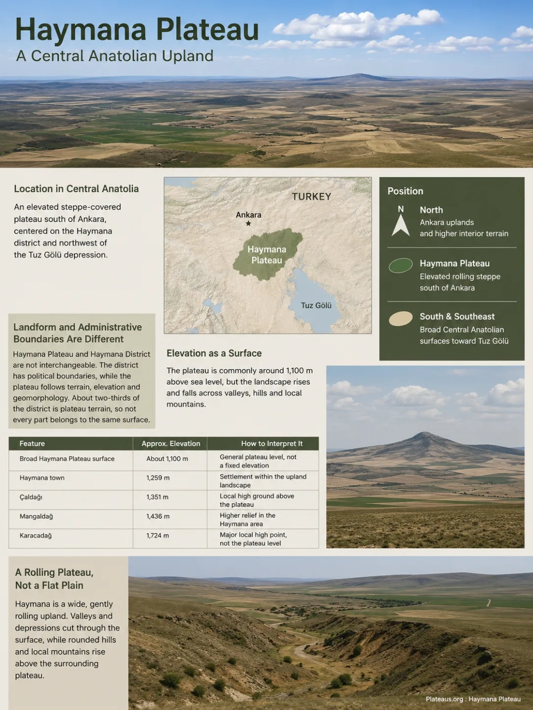
The Haymana Plateau is an elevated, steppe-covered upland south of Ankara in Central Anatolia. Its landscape is not a single flat tableland: broad surfaces around roughly 1,100 meters are broken by shallow valleys, rounded hills and higher local ridges, while cultivated fields emphasize the open character of the terrain.
Where the Haymana Plateau Lies in Central Anatolia
The Haymana Plateau occupies part of the upland country south of Ankara, around the district of Haymana and northwest of the Tuz Gölü depression. It belongs to the much larger system of basins, plateaus and mountain blocks that make up the interior of Central Anatolia.
Haymana is therefore best understood at more than one geographic scale. Locally, it is a distinct elevated surface associated closely with the Haymana district. Regionally, it forms part of the transition between the Ankara uplands, the upper Sakarya drainage area and the drier interior around Tuz Gölü.
Ankara uplands and the higher interior terrain surrounding the capital
Elevated rolling steppe south of Ankara, centered on the Haymana area
Broad Central Anatolian surfaces leading toward the Tuz Gölü region
Landform and Administrative Boundaries Are Different
Haymana Plateau and Haymana District are not interchangeable terms. Haymana District is an administrative area with mapped political boundaries. The plateau is a physical landform whose limits follow terrain, elevation and geomorphology rather than district lines. Local geographic descriptions indicate that roughly two-thirds of the district is plateau terrain, which also means that not every part of the district belongs to the same surface.
Elevation Is Better Understood as a Surface Than a Single Number
The Haymana Plateau is commonly associated with elevations of about 1,100 meters above sea level, but this figure describes the general level of broad plateau surfaces rather than every point on the landform. Valleys descend below surrounding interfluves, while hills and ridges rise hundreds of meters above the characteristic plateau level.
Haymana town itself stands at approximately 1,259 meters, already higher than the broad 1,100-meter reference often given for the plateau. Several local uplands rise farther above the surrounding surface.
| Feature | Approximate Elevation | How to Interpret It |
|---|---|---|
| Broad Haymana Plateau surface | About 1,100 m | General plateau level, not a fixed elevation across the whole area |
| Haymana town | 1,259 m | Settlement elevation within the wider upland landscape |
| Çaldağı | 1,351 m | Local terrain rising above the broader plateau surface |
| Mangaldağ | 1,436 m | Higher local relief within the Haymana area |
| Karacadağ | 1,724 m | A major local high point, not the elevation of the plateau as a whole |
Elevation Note
A statement such as “the Haymana Plateau is 1,100 meters high” is useful only as a broad reference. Plateau elevation, settlement elevation and summit elevation describe different parts of the landscape. Treating the highest nearby hill as the plateau’s elevation would exaggerate the height of the main surface.
A Rolling Plateau Rather Than a Flat Plain
Haymana demonstrates why a plateau should not be imagined as a perfectly horizontal surface. Much of the landscape consists of wide, gently rolling uplands separated by valleys and low depressions. Rounded slopes and isolated higher ground remain above the more subdued parts of the terrain.
From a distance, large cultivated fields can make some parts of the plateau look nearly flat. The underlying relief becomes clearer where stream valleys cut across the surface or where resistant hills rise above surrounding farmland.
Large areas retain comparatively gentle relief at a high regional elevation.
Low divides between drainage lines give the plateau its rolling appearance.
Streams have cut into the surface, preventing the plateau from forming one uninterrupted level.
More elevated hills and ridges stand above the characteristic plateau level.
Why Haymana Is a Plateau Instead of a Plain
The distinction is based less on whether the ground looks flat and more on its regional elevation and relationship to surrounding terrain. Haymana is an upland surface that has been dissected by erosion. A plain, by contrast, usually describes a broad low-relief surface without requiring this elevated regional position.
Haymana Plateau
- Forms an elevated regional surface
- Includes rolling uplands and local hills
- Is cut by valleys and drainage lines
- Contains relief within the plateau itself
A Typical Plain
- Defined mainly by broad low relief
- May occur at low or moderate elevation
- Often forms a valley, basin or coastal floor
- Does not require an elevated plateau surface
The Haymana Plateau and Haymana Basin Are Not the Same Feature
The name Haymana also appears frequently in geological literature because of the Haymana Basin. This can cause an important terminology problem: the present-day plateau and the geological basin describe different aspects of the same broader region.
The Haymana Basin records a much older phase of Central Anatolia’s geological development. Thick sedimentary sequences accumulated there from the Late Cretaceous through parts of the Paleogene, preserving evidence of changing marine and continental environments during the tectonic evolution of Anatolia.
The plateau, however, is a modern landform visible at the surface. It developed through later uplift, erosion and landscape modification across rocks associated with this older geological setting and younger sedimentary units.
Two Different Meanings of Haymana
Haymana Basin: a geological and depositional basin used to describe rock sequences and the tectonic history of the region.
Haymana Plateau: the elevated land surface seen in the present landscape.
A location can belong to the geological history of the basin while also forming part of the younger plateau topography above it.
How the Rocks Help Shape the Surface
Much of the Haymana landscape is developed on sedimentary rocks. Neogene formations in and around the plateau include combinations of limestone, sandstone, marl and clay-rich deposits, while older Upper Cretaceous and Paleogene units associated with the Haymana Basin occur beneath or alongside them.
These rock types do not respond to weathering and erosion in exactly the same way. Harder beds can remain as more resistant uplands or ridges, while softer marl and clay-rich material is generally easier to erode. Over long periods, this contrast helps produce a terrain of broad surfaces, shallow depressions, rounded hills and incised valleys rather than a single smooth plateau top.
Limestone, sandstone, marl and clay-rich units provide rocks with different resistance to erosion.
Softer units are lowered more readily while resistant beds can preserve higher ground.
Drainage cuts into the elevated surface and separates the plateau into rolling interfluves.
The result is an elevated but irregular steppe surface with valleys, hills and broad cultivated uplands.
Valleys Have Broken Up the Original Upland Surface
The Haymana Plateau lies close to the eastern side of the wider Sakarya River drainage system. Numerous smaller channels and tributary valleys cross the uplands, carrying water away from local divides and gradually cutting into the plateau surface.
This drainage is one reason the landscape is better described as dissected or rolling rather than simply flat. Valleys may be shallow across gentler terrain and more clearly incised where streams have cut through resistant or elevated sections.
Seasonal variation is also important. Central Anatolia’s continental setting means that many minor drainage lines carry far less water during dry periods than during wetter parts of the year. A dry valley floor can still represent a long-lived erosional feature even when no permanent stream is visible.
What “Dissected Plateau” Means Here
Dissection does not mean that the plateau has disappeared. It means erosion has cut valleys into an older or broader upland surface, leaving intervening areas of higher ground. Haymana retains a recognizable plateau character even though its surface has been divided by drainage.
Steppe Conditions Define Much of the Visible Landscape
The plateau lies in the continental interior of Türkiye, where summers are generally dry and winters are cold. The combination of inland position, elevation and limited moisture supports an open Central Anatolian steppe landscape rather than extensive natural forest across most of the plateau.
Vegetation patterns are also influenced by local soils. Research in the Haymana area has identified steppe communities on marl-rich and locally gypsum-bearing substrates. Differences in soil depth, carbonate content, slope position and moisture availability can produce noticeable changes in plant cover across relatively short distances.
The natural appearance of the plateau has been strongly modified by agriculture. Broad surfaces and gentle slopes allow large areas to be cultivated, so much of the modern landscape consists of open fields separated by uncultivated slopes, valley margins, roads and patches of steppe vegetation.
Why Cultivation Can Make the Plateau Look Flatter
Large agricultural parcels create long, continuous visual lines across the uplands. Plowing and field boundaries also reduce some of the small-scale surface texture that would otherwise make gentle undulations more obvious. The underlying topography remains rolling even where cultivated ground appears almost level when viewed from a road or distant ridge.
Open grass and herb communities reflect the dry continental environment and local soil conditions.
Broad fields occupy many gentle surfaces, emphasizing the wide horizontal scale of the plateau.
Steeper slopes and drainage corridors reveal the relief that is less obvious across cultivated surfaces.
Higher Hills Do Not Contradict the Plateau Classification
Karacadağ, Mangaldağ, Çaldağı and other elevated features show that a plateau can contain substantial local relief. The classification applies to the dominant regional surface, not to the requirement that every point lie at almost the same elevation.
A useful way to read Haymana’s terrain is to separate absolute elevation from local relief. A field at 1,200 meters can belong to a broad plateau surface, while a nearby ridge several hundred meters higher can form a local topographic high within the same wider upland region.
This distinction also explains why topographic maps of the Haymana area show both wide-spaced contours across gentle surfaces and tighter contour spacing along valleys or hill slopes. The two patterns are parts of one landscape rather than evidence for conflicting landform classifications.
Haymana Within the Larger Central Anatolian Landscape
The Haymana Plateau is only one part of Central Anatolia’s complex interior relief. It should not be treated as another name for the Anatolian Plateau as a whole. The larger regional plateau includes numerous basins, volcanic areas, mountain blocks, uplands and separate named plateau surfaces extending far beyond Ankara.
Haymana’s position is especially clear when compared with the lower Tuz Gölü depression and the broad uplands farther south. The contrast between elevated surfaces and interior basins is a recurring feature of Central Anatolian geography.
| Landform | Regional Position | Landscape Character | Relationship to Haymana |
|---|---|---|---|
| Haymana Plateau | South of Ankara | Rolling, dissected steppe upland | The specific plateau landform discussed here |
| Tuz Gölü Basin | Southeast of the Haymana area | Lower interior basin centered on a saline lake | Provides a regional contrast between elevated upland and basin terrain |
| Cihanbeyli Plateau | South and southwest of the Tuz Gölü region | Broad dry Central Anatolian upland | A separate named plateau within the same wider interior landscape |
| Anatolian Plateau | Across much of interior Türkiye | Large regional system of uplands, basins and mountain areas | The broader physiographic setting that contains Haymana and many other landforms |
Reading Haymana on a Physical Map
The plateau is easiest to recognize by combining elevation and relief rather than searching for a sharp boundary line. Look for the broad upland south of Ankara, the lower Tuz Gölü region to the southeast, valleys cutting through the Haymana surface, and local hills rising above the general plateau level. A physical or shaded-relief map usually communicates this relationship better than an administrative map.