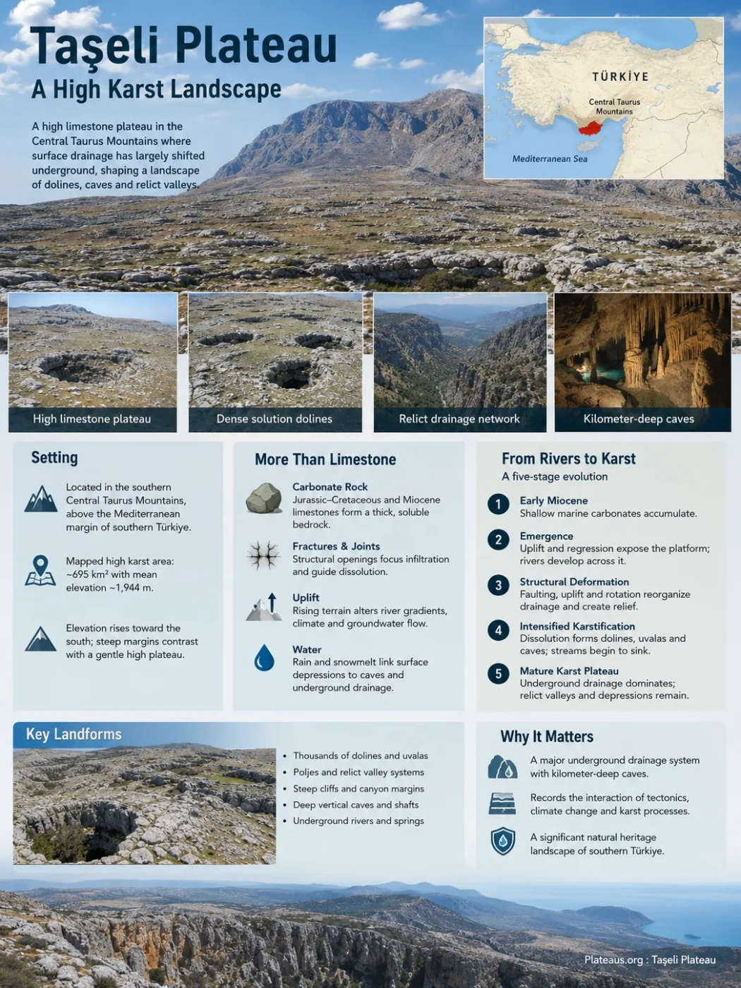
Central Taurus Karst • Southern Türkiye
The Taşeli Plateau is a high limestone surface in the Central Taurus Mountains where thousands of closed depressions, abandoned valley networks and deep vertical caves record a major shift from surface drainage to underground karst drainage. Its landscape is not simply the product of limestone dissolving in rainwater: uplift, fractures, former rivers, elevation and continued river incision all helped create the terrain seen today.
Dense solution dolines
Relict drainage network
Kilometer-deep caves
A High Karst Surface in the Central Taurus
Taşeli lies in the southernmost part of the Central Taurus Mountains, above the Mediterranean margin of southern Türkiye. Much of its best-developed high karst lies north of Anamur, where elevated limestone surfaces contrast sharply with deeply cut valleys and steep plateau margins.
The name does not always describe exactly the same boundary. Taşeli can refer to a broader rugged region of the Central Taurus, while geomorphological studies may use a more tightly defined high-plateau area. This distinction matters when elevation, area or landform counts are quoted.
Geographic Scope
A detailed geomorphological study covering most of the high karst plateau examined about 695 km² and calculated a mean elevation of about 1,944 m. Those measurements describe the mapped research area, not every broader regional use of the name Taşeli.
Within that mapped area, elevation generally rises toward the south. The plateau top is dominated by comparatively gentle limestone surfaces, while the southern and western margins become much steeper. This contrast between a subdued high interior and sharply dissected edges is one of the defining features of Taşeli.
Why Limestone Alone Does Not Explain the Karst
Taşeli contains extensive carbonate rocks from more than one geological period. Jurassic–Cretaceous limestones form major parts of the older carbonate foundation, while Miocene limestones cover large parts of the plateau surface. These soluble rocks provide the material in which karst develops, but rock type is only one part of the process.
The plateau has also been affected by faulting, jointing, rotation and uplift. Fractures give water pathways into the limestone. Once water enters those openings, dissolution can widen them and progressively connect surface depressions with deeper underground conduits.
Thick limestone units provide a large volume of soluble bedrock in which surface and underground karst can develop.
Structural openings concentrate infiltration and help determine where dissolution penetrates into the rock mass.
Rising terrain changes river gradients, local climate and the vertical distance through which groundwater can circulate.
Rain and snowmelt enter depressions and fractures, linking surface landforms with cave passages and underground drainage.
The result is a fluvio-karstic plateau: a landscape that preserves evidence of both former river erosion and later karst reorganization. Taşeli cannot be understood as a purely fluvial plateau or as a karst surface that developed independently of its earlier drainage network.
How a Rivered Surface Became a Karst Plateau
The present landscape developed through several linked phases rather than one episode of erosion. Research on Taşeli reconstructs a five-stage sequence in which marine sedimentation, emergence, structural deformation, uplift and karstification progressively changed how water moved across the plateau.
Shallow-Water Carbonates Accumulate
Carbonate sediments were deposited in a shallow marine environment, adding limestone that would later become part of the elevated plateau surface.
The Area Emerges and Rivers Develop
As the region became terrestrial, a surface drainage network began cutting across the newly exposed landscape. Taşeli therefore had an organized river system before dense karst depressions came to dominate its surface.
Dense Joint Systems Form
Clockwise rotation of the eastern limb of the Isparta Angle, estimated at roughly 40°, was associated with fault and joint development. A strong NW–SE structural orientation became imprinted on the plateau.
Rapid Uplift Changes Drainage
Rapid uplift increased relief and altered climatic conditions on the high surface. Underground karstification expanded, surface valleys began to lose water and headward erosion became stronger along the southern margin.
Dolines Replace Parts of the Old Drainage Network
Solution depressions became densely established across the plateau. Dolines developed within former valley floors, while sections of the old surface drainage network became relict valleys as more water was transferred underground.
The Doline Fields That Dominate the Plateau Surface
The clearest surface expression of Taşeli karst is the enormous number of solution dolines. These are closed depressions produced mainly by dissolution and related karst processes rather than ordinary river erosion.
Mapped Dolines
Identified from 1:25,000-scale topographic mapping in the studied plateau area.
Relict Valley Segments
Mapped remnants of an older surface drainage system.
Mapped Area
The research area from which the doline and relict-valley inventory was derived.
Maximum Mapped Density
The highest local doline density recorded in the topographic-map analysis.
The mapped dolines occur mainly between about 1,500 and 2,300 m. Nearly three-quarters of them fall between approximately 1,900 and 2,250 m, concentrating the strongest doline development on the high southern part of the plateau.
This elevation pattern is not accidental. The most densely karstified area also corresponds to the colder and wetter high part of the mapped plateau. More moisture, seasonal snow and snowmelt can supply water for dissolution, while gentle slopes allow closed depressions to survive more readily than on actively eroding steep terrain.
When Dolines Become Polygonal Karst
In the densest zones, individual depressions are packed so closely that the landscape approaches polygonal karst. Ridges separating neighboring dolines form an irregular network, leaving relatively little uninterrupted plateau surface between closed basins.
This is different from a landscape where isolated sinkholes occur within an otherwise continuous plain. On Taşeli’s most strongly karstified high surfaces, the depressions themselves become the dominant topographic pattern.
How to Read the Doline Count
The figure of 14,284 is a mapped inventory, not a permanent claim that the entire Taşeli Plateau contains exactly that number of depressions. Mapping resolution changes what can be detected. In two small Taşeli test areas, conventional topographic maps identified 99 and 84 dolines, while high-resolution UAV-derived elevation models detected 141 and 142. Small or subtle depressions are easier to recognize when the terrain model has finer spatial resolution.
Relict Valleys Preserve an Older Drainage Network
Taşeli’s dolines become more informative when they are considered together with its relict valleys. These are inherited valley forms whose original surface-flow function has been weakened or lost as karst drainage developed.
They show that much of the plateau was once crossed by a more continuous river network. As fractures widened and subsurface drainage became more effective, water was increasingly captured below ground. Dolines then formed along and within older valley floors.
Streams initially organize drainage across the exposed plateau.
Water increasingly enters joints and openings in the limestone.
Subsurface conduits take a larger share of runoff that once remained in surface channels.
Closed depressions interrupt the continuity of the former drainage lines.
Valley geometry survives even though the original surface drainage system has been reorganized.
Doline density and relict-valley density show a positive spatial relationship across the studied plateau. Larger and more complex depressions are also associated with higher-order former valleys. This connection is strong evidence that the older river pattern influenced where later karst depressions developed.
The reconstructed paleodrainage is broadly dendritic and multibasinal. Much of the former surface flow was directed northward toward the Ermenek River system, even though some of the highest parts of the plateau lie closer to the Mediterranean coast to the south. Present topography therefore cannot be read simply by assuming that water always followed the shortest route toward the sea.
Karst Forms Occur at Several Scales
Dolines and relict valleys dominate the mapped high surface, but they form part of a wider limestone landscape. Dissolution operates from grooves on exposed rock to depressions large enough to collect sediment and interrupt regional drainage.
| Landform | Form on the Plateau | What It Reveals |
|---|---|---|
| Karren | Grooves, fissures and etched surfaces developed directly on exposed limestone. | Small-scale dissolution where water acts on the rock surface. |
| Solution doline | Closed circular, oval or elongated depression; exceptionally dense on parts of the high plateau. | Transfer of surface water into a karst drainage system. |
| Uvala | Larger irregular or compound closed depression occurring locally where karst basins become more complex. | Expansion or interaction of neighboring karst depressions. |
| Polje | Broad, relatively flat-floored karst depression found in parts of the wider Taşeli landscape. | Concentration of sediment, soil and seasonal surface water within a larger closed basin. |
| Ponor or swallow point | Opening or drainage point through which surface water can enter limestone. | Direct connection between surface runoff and underground flow. |
| Relict valley | Former drainage line preserved after continuous surface flow has been disrupted by karstification. | The layout of an older fluvial landscape beneath the modern karst pattern. |
| Vertical cave system | Deep shafts and passages descending far below the plateau surface. | The large vertical extent of underground drainage and limestone dissolution. |
The Surface Karst Continues More Than a Kilometer Underground
The Anamur sector of Taşeli contains several exceptionally deep cave systems. They show that the closed depressions visible at the surface are only the upper expression of a much larger underground landscape.
| Cave System | Reported Surveyed Depth | Reported Surveyed Length | Karst Context |
|---|---|---|---|
| Peynirlikönü / EGMA | 1,429 m | 3,118 m | A major vertical sinkhole system in the high karst near Anamur. |
| Morca | 1,276 m | 5,714 m | Deep system developed near the contact between Miocene and Jurassic–Cretaceous limestones. |
| Çukurpınar | 1,196 m | 3,350 m | Another deep vertical system within the same high-karst sector. |
These figures are surveyed cave dimensions, not measurements of the total thickness of the plateau or proof that every underground passage has been found. Exploration can stop at flooded passages, narrow restrictions or unexplored branches.
Morca is especially useful for understanding the plateau structurally. Its cave system lies near the contact between younger Miocene carbonate cover and older Jurassic–Cretaceous limestone. Water entering the high surface descends through a succession of shafts, passages and active underground watercourses, linking surface geology with deep karst development.
Water Often Leaves the Surface Before It Leaves the Plateau
Dense karst changes the meaning of drainage. A plateau does not need a large visible stream network at the surface for substantial amounts of water to be moving through it.
Water reaches the high limestone surface.
Runoff is concentrated into closed depressions, joints and openings.
Water moves downward through fissures, shafts and cave passages.
Flow becomes concentrated below the surface and may travel beyond the visible closed depression.
Groundwater eventually returns to lower valleys and contributes to active drainage around the plateau.
This underground transfer helps explain why former valleys can remain visible even after losing continuous surface flow. It also explains why the plateau can contain both intensely closed karst terrain and major river systems nearby: water disappearing into limestone is not removed from the hydrological system, only redirected through it.
Why the Plateau Interior and Its Margins Look So Different
Taşeli contains two contrasting geomorphic settings within a short distance. The high interior preserves dense karst depressions and inherited drainage forms, while major rivers attack the plateau margins and cut steep valleys into the elevated limestone mass.
High Plateau Interior
- Broad areas of comparatively gentle limestone surface
- Dense solution dolines and polygonal karst
- Relict valley networks
- Strong infiltration into underground drainage
- Best preservation of closed karst depressions
Dissected Plateau Margins
- Much steeper slopes and stronger local relief
- Active river valleys cutting into the plateau
- Headward erosion extending toward the high surface
- Greater removal or destruction of older karst forms
- Surface runoff becomes more important within incised valleys
Headward erosion is particularly important along the southern margin. As Mediterranean-facing streams cut progressively inland, steep valley heads can consume parts of the older high surface. Dolines that remain well preserved on gentle ground may be truncated or removed where those active valleys reach the plateau.
Taşeli is therefore not a static limestone table. Its interior still preserves the dense imprint of karst drainage reorganization, while its edges are being reshaped by rivers cutting back into the uplifted plateau.