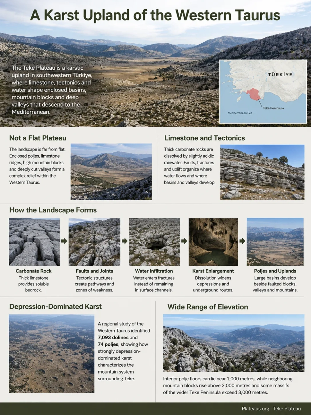
The Teke Plateau of southwestern Türkiye is not a single flat surface lying neatly between the Taurus Mountains and the Mediterranean. It is better understood as a karstic upland within the Western Taurus, where thick carbonate rocks, tectonic faults, enclosed poljes, high mountain blocks and deeply cut valleys form a closely connected landscape. Toward the coast, parts of this karst system descend abruptly to the Mediterranean and, around Kaş and Kekova, continue below present sea level.
Teke Is a Karst Upland Within the Western Taurus
The name Teke Plateau can create the impression of a broad, level tableland. The terrain is much more irregular. Large enclosed basins sit between limestone ridges and mountain massifs, while valleys and canyons dissect parts of the upland. Some surfaces are relatively open and gently rolling; others are steep, rocky or broken by thousands of karst depressions.
The plateau belongs to the wider Teke Peninsula in southwestern Türkiye. That peninsula projects into the eastern Mediterranean between the Fethiye side in the west and the Antalya Gulf in the east and forms part of the western end of the Taurus mountain system. The plateau therefore should not be pictured as a separate landform squeezed between mountains and sea. The mountains, plateau surfaces, poljes and coastal slopes are parts of the same regional relief system.
Geography Note
“Teke Plateau” is a useful regional landform name, but it does not describe a uniformly flat surface with one universally fixed boundary. Scientific studies commonly divide the wider Teke landscape into mountain massifs, karst basins and more specifically defined plateau sectors such as the Kaş–Demre Karst Plateau.
This distinction matters when interpreting elevation. A single average plateau elevation would conceal much of the actual terrain. Interior polje floors can lie near 1,000 metres, while neighboring mountain blocks rise well above 2,000 metres and some massifs of the wider Teke Peninsula exceed 3,000 metres.
Limestone Provides the Rock, but Tectonics Organizes the Landscape
Karst is the defining physical process across much of Teke because carbonate rocks are widespread in the Western Taurus. Rainwater absorbs carbon dioxide from the atmosphere and soil, becomes weakly acidic and slowly dissolves limestone along joints, bedding planes and fractures. Over long periods, these openings can develop into dolines, swallow holes, underground drainage routes, caves and large closed depressions.
Limestone alone does not explain the arrangement of the landforms. The Western Taurus has a complicated tectonic history involving folding, thrusting, faulting and uplift. Carbonate units occur within structures including the Beydağları Autochthon and the Lycian nappes, while younger fault systems cut the older mountain architecture.
Research on surface karst across the Western Taurus has found that the long axes and distribution of many dolines and poljes correspond closely with geological structures. NE–SW is especially important for many poljes, while E–W and NW–SE orientations also occur. Faults and fractures provide zones where water can penetrate more easily, while tectonic movement can create or modify the depressions in which larger karst basins develop.
Regional Karst Scale
A morphometric study of the Western Taurus as a whole identified 7,093 dolines and 74 poljes. These are regional figures rather than a count for the Teke Plateau alone, but they show how strongly depression-dominated karst characterizes the mountain system surrounding Teke.
Thick limestone formations provide soluble bedrock.
Tectonic structures create preferred pathways and zones of weakness.
Water enters fractures instead of remaining entirely in surface channels.
Dissolution widens depressions and underground drainage routes.
Large closed basins develop beside faulted limestone blocks, valleys and mountain ridges.
Poljes Form the Broadest Flat Surfaces Inside Teke
The most characteristic open low-relief surfaces are not continuous plateau plains but poljes: large karst depressions with relatively flat floors and steep or clearly defined margins. The Western Taurus contains many of Türkiye’s best-known examples, including Elmalı and Korkuteli.
These depressions explain why broad cultivated plains can occur inside otherwise rugged limestone country. Material eroded from surrounding slopes and sediment carried into a closed basin can accumulate on the floor, producing deeper soils and flatter land than on the exposed limestone around it. Agriculture and settlement therefore tend to concentrate disproportionately on some polje floors.
Elmalı Is a Clear Example of the Basin-and-Mountain Contrast
The Elmalı depression is one of the clearest examples. The Avlan Lake area at its southern end lies roughly around 1,020–1,050 metres above sea level, yet it is enclosed by much higher Western Taurus terrain. The basin contains swallow holes and has a strongly karstic drainage pattern rather than a fully developed conventional river network.
This geometry also affects flooding. A polje may be internally drained without remaining permanently dry. During periods of high runoff, water can collect on the floor when inflow temporarily exceeds the capacity of swallow holes or when drainage openings become obstructed. A landscape can therefore be both strongly karstic and periodically flooded.
Korkuteli Extends the Polje Pattern Northeastward
Korkuteli belongs to the same broader Western Taurus zone of large karstic depressions. Together with Elmalı and neighboring basins toward the Lakes Region, it shows that the interior relief is arranged around alternating uplands and structural-karst depressions rather than one continuous plateau surface.
Smaller Polje Groups Occur on Higher Karst Terrain
Large basin floors are only one level of the karst system. Studies west of the main Teke uplands have also documented groups of poljes on the Boncuk Mountains, including the Ballık poljes. Their presence on elevated terrain helps show that karst development is distributed across several topographic levels rather than confined to the largest interior basins.
Water Commonly Leaves the Surface Before Leaving the Basin
A normal surface-water map can understate the importance of drainage in the Teke karst. On impermeable terrain, rainfall is organized mainly into streams that remain visible as they move downstream. On fractured limestone, part of that water enters the rock and may travel through an underground network instead.
Visible at the Surface
- Seasonal streams
- Polje-floor channels
- Temporary ponding or lakes
- Incised valleys and canyons
Hidden Underground
- Water entering joints and fractures
- Swallow holes and ponors
- Subsurface conduits
- Karst springs where water re-emerges
The Elmalı–Avlan area demonstrates this relationship well. Extensive karstification has limited development of a dense surface river network, while swallow holes play an important role in draining parts of the basin. Similar surface-to-subsurface transfers occur throughout the Western Taurus.
Underground drainage also means that topographic divides do not always tell the complete hydrological story. Water falling inside one apparent surface basin can enter limestone and follow geological structures before reappearing at a spring elsewhere. Near the Mediterranean margin, karst circulation can extend toward coastal and submarine discharge zones.
The Mediterranean-to-Interior Relief Changes Over a Short Distance
Teke contains an unusually strong juxtaposition of Mediterranean coast, steep limestone mountains and elevated interior depressions. The change is not a simple climb from sea level to one plateau surface. Mountain blocks, basin floors and dissected uplands alternate across the region.
Sea-level coast, steep limestone slopes and deeply cut valleys.
Karst surfaces, mountain massifs, dolines and fault-controlled relief above the coast.
Elevated enclosed basins such as Elmalı and Korkuteli with broad, relatively flat floors.
The wider Teke Peninsula contains several high massifs. Akdağ reaches about 3,017 metres, while Beydağları reaches about 3,070 metres. These elevations contrast sharply with the Elmalı polje floor near 1,000 metres and the nearby Mediterranean coast at sea level.
This relief also produces strong climatic differences. Coastal areas experience a typical Mediterranean pattern of hot, dry summers and mild, wetter winters. Interior basins such as Elmalı are higher, colder and more continental in character. Frost and winter cold become much more important there than along the nearby coast.
At the highest levels, the geomorphic history extends beyond karst. Late Quaternary glaciers developed on high massifs of the Teke Peninsula, including Sandıras, Karadağ, Akdağ and Beydağları. Cirques and moraines preserved on these mountains record colder conditions during the Pleistocene. The modern landscape is therefore a combination of long-term karst development, tectonic deformation, river incision and, at the highest elevations, former glacial erosion.
Kaş–Demre Reveals a Stepped Karst Landscape Reaching Below the Sea
The southern Teke Peninsula provides one of the clearest demonstrations that the region’s karst cannot be explained by dissolution alone. The Kaş–Demre Karst Plateau, between Kaş, Demre, the Kasaba area and Kekova, contains a sequence of tectonically controlled karst depressions that developed while the region was being uplifted, faulted and dissected.
A 2026 geomorphological study mapped the area’s faults, rock units and landforms in detail. It found that extensional tectonics active from the late Pliocene and especially during the Quaternary produced horst-and-graben relief. Some grabens became sites for a distinctive sequence of cascade-type poljes, in which karst depressions occur at different structural levels across a stepped landscape.
Uplifted karst terrain separated by faults.
Closed depression developed within a structurally lowered sector.
Vertical displacement creates another topographic level.
A younger depression closer to the Mediterranean base level.
The lowest parts of the system now lie beneath coastal waters.
The southern end of this sequence is especially unusual. The Kaleüçağız and Kekova poljes were lowered relative to sea level and later submerged. Evidence from the Kekova polje includes a karst corrosion surface identified about 131 metres below present sea level, covered by approximately 22 metres of sediment. This records repeated interaction between tectonic movement, karst development and changing Quaternary sea levels.
The important point is not simply that the coastline flooded a valley. Parts of an earlier terrestrial karst landscape now continue below the Mediterranean. Coastal bays around Kekova therefore preserve sections of a geomorphic system whose development began when those surfaces were exposed on land.
Demre Canyon Cuts Across the Karst Instead of Disappearing Into It
Karst landscapes are often associated with disappearing streams, yet the Demre Stream shows that strong surface incision can exist within the same system. The stream gathers water in the northern Kasaba Basin and crosses the limestone uplands on its route toward the Mediterranean.
Its canyon is tied to the tectonic evolution of the plateau. As the region continued to rise and local base levels changed, the established drainage maintained its course and cut downward into the uplifting terrain. The result is a deeply incised valley crossing a landscape otherwise dominated by closed depressions and underground drainage.
This relationship explains an apparent contradiction in Teke. Karstification does not eliminate surface rivers everywhere. Rock type, inherited drainage, fault structure, uplift and the availability of non-carbonate sediments can allow a surface channel to persist while neighboring water is diverted underground.
Teke Plateau, Teke Peninsula and Kaş–Demre Describe Different Scales
Several overlapping geographic names are used for southwestern Türkiye, and treating them as exact synonyms can produce misleading maps or elevation claims.
| Term | Geographic Meaning | Best Interpretation |
|---|---|---|
| Teke Peninsula | The broad southwestern peninsula between the Fethiye and Antalya sides of the Mediterranean coast. | A regional geographic unit containing mountains, basins, karst plateaus and coastal terrain. |
| Teke Plateau | A regional name for karstic uplands within the Western Taurus part of the Teke region. | Not one uniform tableland with a single easily mapped elevation or edge. |
| Western Taurus Karst | The wider geomorphological system containing extensive limestone, dolines, poljes and underground drainage. | A broader scientific context that extends beyond Teke itself. |
| Kaş–Demre Karst Plateau | A more specifically defined southern plateau sector between the Kaş, Demre, Kasaba and Kekova area. | A fault-controlled coastal karst system containing cascade-type and submerged poljes. |
This difference in scale is also why values measured in one part of Teke should not automatically be presented as statistics for the entire plateau. An elevation from Elmalı, a mountain summit in Beydağları or a depth from the submerged Kekova system describes a specific part of a highly varied landscape.
Teke and Taşeli Are Two Different Expressions of Taurus Karst
Teke and Taşeli are often grouped together as Turkish examples of karstic plateaus. That classification is useful at a broad level, but it can obscure differences between the landscapes.
Teke
- Part of the Western Taurus.
- Large poljes are prominent elements of the interior relief.
- Mountain blocks and enclosed basins alternate over short distances.
- Fault orientation strongly influences many poljes and dolines.
- Southern karst descends directly toward the Mediterranean.
- Kaş–Demre includes stepped and submerged polje systems.
Taşeli
- Belongs mainly to the Central Taurus karst region farther east.
- Broad high limestone surfaces are more continuous in many sectors.
- Extensive doline fields are especially characteristic.
- Deep valleys dissect parts of the high plateau surface.
- Karst drainage includes major underground systems and springs.
- Its surface morphology should not be used as a direct model for Teke.
The distinction helps explain the physical identity of Teke more precisely. Its landscape is defined less by one continuous elevated plain than by the interaction of Western Taurus limestone, tectonic structures, large enclosed poljes, underground drainage, high mountain relief and a rapidly descending Mediterranean margin.