Regional Plateau Systems
Western China contains the planet's highest broad upland, dry desert plateaus, thick loess tablelands, and humid karst highlands. These landforms form a stepped landscape rather than one continuous plateau.
Western China's plateaus are a hierarchy of large systems and smaller named regions. The Qinghai-Tibet Plateau forms the very high core. The Pamir Plateau reaches China's far-western borderlands, while the Loess, western Inner Mongolia, and Yunnan-Guizhou plateaus occupy lower parts of the national topographic staircase. Names such as Qiangtang, Alxa, Ordos, and Western Sichuan describe subregions or overlapping units within that larger pattern.
Where the Plateau Belts Sit
Map Note
This map is for regional orientation. Google Maps does not draw scientific plateau boundaries, and the term western China has no single physical boundary. The plateau belts extend across provincial borders and, in several cases, beyond China.
Inventory of Major Plateaus and Named Subregions
The inventory separates parent plateau systems from named subdivisions and transition zones. It includes units repeatedly identified as plateaus in geographic or physiographic descriptions of western, northwestern, and southwestern China. Local terraces and isolated tablelands are outside its scope.
| Plateau or Region | Scale in the Inventory | Main Area in China | Typical Elevation | Landscape and Relationship |
|---|---|---|---|---|
| Qinghai-Tibet Plateau | Parent system | Xizang and Qinghai; parts of western Sichuan, northwestern Yunnan, southern Gansu, and southern Xinjiang | Mostly 4,000-5,000 m | Tectonically raised high plateau containing mountain chains, broad basins, alpine steppe, glaciers, and many lakes |
| Qiangtang Plateau Changtang | Tibetan subregion | Northern and northwestern Xizang | Around or above 5,000 m across broad areas | Very high, cold interior of the Qinghai-Tibet Plateau with shallow relief, inland drainage, salt lakes, and alpine steppe |
| Qinghai Plateau | Tibetan subregion | Much of Qinghai outside the deepest enclosed basins | Broadly 3,000-5,000 m | Northeastern sector of the Qinghai-Tibet Plateau; includes major headwater country and grades toward the Qilian and Loess margins |
| Hoh Xil High Plateau Region Kekexili | Tibetan subregion | Southwestern Qinghai and adjoining high country | Generally above 4,500 m | Alpine mountains, steppe, permafrost terrain, and lake basins on the northeastern Qinghai-Tibet Plateau |
| Western Sichuan Plateau | Tibetan margin | Western Sichuan, especially Garze and Ngawa highlands | Mostly above 3,000 m | Eastern and southeastern plateau margin broken by the Hengduan ranges and deep upper Yangtze tributary valleys |
| Pamir Plateau | Transboundary highland | Far-western Xinjiang around Taxkorgan and the eastern Pamir ranges | Much of the wider region exceeds 4,000 m | A mountain-knot highland where ranges and high valleys meet; only its eastern part lies in China |
| Inner Mongolia Plateau, Western Sector | Parent system edge | Western Inner Mongolia and adjoining northern highlands | Commonly 1,000-2,000 m across the full system | Second-step plateau with rolling uplands, grassland, Gobi surfaces, and large desert tracts |
| Alxa Plateau Alashan Plateau | Inner Mongolia subregion | Westernmost Inner Mongolia, west of the Helan Mountains | About 820-1,400 m over much of the region | Arid high plains with Gobi surfaces and the Badain Jaran, Tengger, and Ulan Buh desert areas |
| Ordos Plateau | Transition and overlap zone | Inside the great northern bend of the Yellow River; Inner Mongolia, Ningxia, Shaanxi, and nearby areas | Roughly 1,000-1,600 m | Also described as a sedimentary basin; its north is dry and sandy, while its south overlaps the loess country |
| Loess Plateau | Parent system | Gansu, Ningxia, Shaanxi, Shanxi, and adjoining Qinghai, Inner Mongolia, and Henan margins | Mostly 1,000-2,000 m; locally lower or higher | Thick windblown silt mantle cut into platforms, ridges, hills, gullies, and river valleys |
| Central Gansu Plateau | Loess subregion | Central and eastern Gansu | Often within the 1,500-2,000 m loess belt | Dry, deeply dissected western part of the Loess Plateau; commonly treated as a regional division |
| Northern Shaanxi Plateau | Loess subregion | Northern Shaanxi | Commonly about 900-1,500 m | Loess hills, ridges, and dense gullies draining toward the middle Yellow River |
| Yunnan-Guizhou Plateau Yungui Plateau | Parent system | Eastern Yunnan, most of Guizhou, and adjoining southwestern highlands | Mostly 1,000-2,000 m, rising toward the northwest | Rugged plateau with limestone karst, enclosed basins, ridges, and deep river gorges |
| Yunnan Plateau | Yungui subregion | Central and eastern Yunnan, west of the Guizhou sector | Often 1,500-2,500 m, with large local variation | Higher western part of the Yunnan-Guizhou system, containing fault basins, lake basins, karst surfaces, and mountain blocks |
| Guizhou Plateau | Yungui subregion | Most of Guizhou | Average near 1,100 m; much wider local range | Eastward-descending karst highland divided by the Wu, Beipan, and other river systems |
Classification Note
The rows are not additive areas. Qiangtang, Qinghai, Hoh Xil, and Western Sichuan belong to the wider Qinghai-Tibet system; Alxa belongs to the western Inner Mongolia system; and the Yunnan and Guizhou plateaus are the main sides of the Yunnan-Guizhou system. Ordos is described both as a plateau and as a sedimentary basin, depending on whether the emphasis is surface form or deep geology.
The Elevation Staircase Across Western China
The clearest large-scale pattern is a descent from the high plateaus near the southwestern and far-western borders toward the lower interior plateaus. Mountain summits rise well above the plateau surfaces, so a plateau's typical elevation should not be confused with its highest peak.
Representative Plateau-Surface Elevation Bands
Approximate meters above sea level; ranges describe broad surfaces, not summit elevations.
Interactive chart library could not be loaded.
Boundaries and reported elevations vary by source and subregion. The Qiangtang and Pamir bands are especially mountainous, while the Loess and Yunnan-Guizhou surfaces contain deep river cuts.
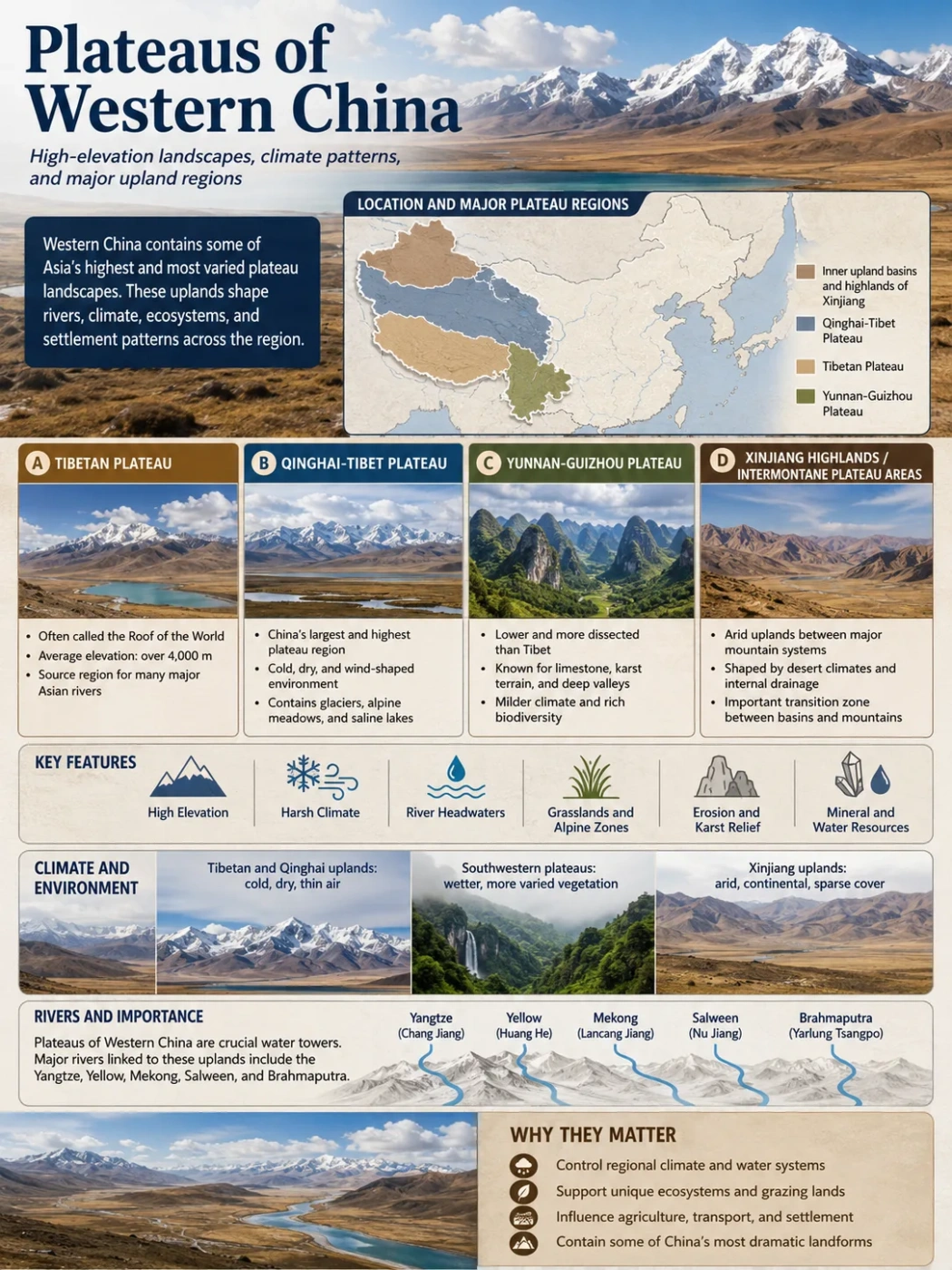
The High Core: Qinghai-Tibet and Its Internal Regions
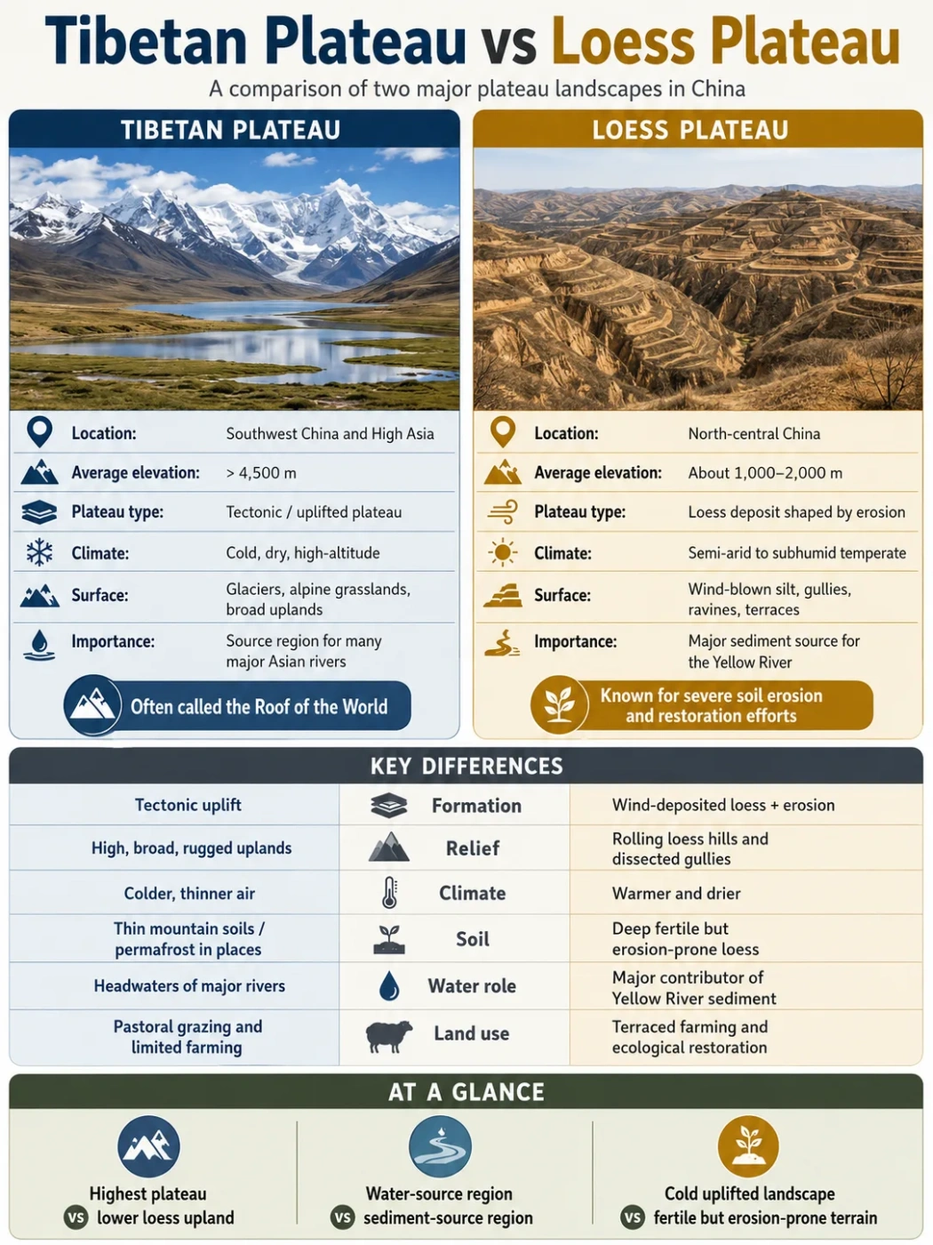
The Qinghai-Tibet Plateau, also called the Tibetan Plateau or Qinghai-Xizang Plateau, dominates the relief of western China. It covers roughly 2.5-2.6 million square kilometers under widely used definitions, although the exact boundary changes with the contour line, geology, or ecological region used to draw it. Most of the surface stands above 4,000 meters.
This is not a flat slab. The Himalaya marks the southern rim, while the Karakoram, Kunlun, Altyn-Tagh, and Qilian systems help define its western and northern sides. The Hengduan ranges break up its southeastern margin. Inside the plateau, the Gangdise, Nyainqentanglha, Tanggula, and Bayan Har ranges separate broad valleys, lake basins, grasslands, and headwater areas.
Qiangtang: The High, Internally Drained Interior
Qiangtang occupies much of northern and northwestern Xizang. It is one of the broadest high surfaces within the parent plateau, with an average elevation often reported above 5,000 meters. Relief across the open interior can be modest compared with the enclosing ranges, even though mountain ridges rise through it.
Many Qiangtang streams end in lakes rather than reaching an ocean. Evaporation, seasonal freezing, snowmelt, and glacier melt all shape these closed basins. Salt lakes and old shorelines record changes in water balance over long periods.
Qinghai and Hoh Xil: The Northeastern High Country
The Qinghai sector includes headwaters of the Yellow, Yangtze, and Lancang rivers as well as enclosed lake basins. Hoh Xil, or Kekexili, lies within this high northeastern region. Much of it is above 4,500 meters, with alpine steppe, permafrost terrain, low average temperatures, and many shallow basins between mountains.
The Qaidam Basin interrupts this plateau country as a lower enclosed depression. It is part of the wider Qinghai-Tibet physiographic region, but its landform class is basin, not plateau.
Western Sichuan: Where the Plateau Becomes Deep Valleys
Western Sichuan shows how a plateau margin can be high without looking level. Its northern section joins the main Qinghai-Tibet surface, while the south merges with the Hengduan Mountains. The Yalong, Dadu, Min, Jinsha, and other rivers have cut long valleys through the uplifted terrain. Local relief can therefore be several kilometers between valley floors and nearby summits.
Elevation Note
A high plateau is defined by a broad raised region, not by an unbroken flat top. Western Sichuan and southeastern Xizang remain part of the plateau margin even where river incision and parallel mountain ranges create very rugged ground.
The Pamir Plateau at China's Far-Western Edge
The Pamir Plateau enters China in western Xinjiang around Taxkorgan. The wider Pamir region crosses several national boundaries, and only its eastern side lies within China. Much of the highland exceeds 4,000 meters, while peaks such as Muztagh Ata rise far above the inhabited valleys.
The Pamir is often described as a mountain knot because several great Asian ranges converge or change direction around it. High valleys and intermontane surfaces sit among heavily glaciated mountains. Meltwater feeds short mountain rivers and supports settlements and grazing areas before the water descends toward the dry basins of Xinjiang.
The Pamir should not be presented as simply another name for the Tibetan Plateau. The two belong to connected high Asia, but they are distinct physiographic regions with different conventional boundaries.
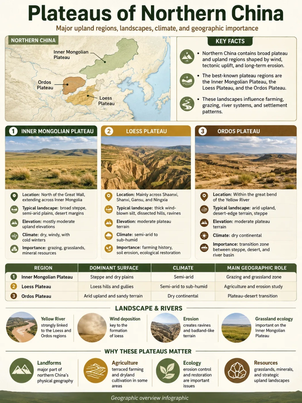
Dry Plateaus North of the Tibetan Rim
North and northeast of the Tibetan highland, elevation drops onto China's second topographic step. The western Inner Mongolia uplands, Alxa Plateau, and Ordos region are lower, drier, and more open than the Tibetan core.
Alxa: High Plains, Gobi, and Large Sand Seas
The Alxa Plateau lies west of the Helan Mountains in western Inner Mongolia. Much of its surface is about 820-1,400 meters above sea level. High plains, stony Gobi, low mountain blocks, and sandy desert occur together. The Badain Jaran, Tengger, and Ulan Buh desert areas occupy large parts of the region.
Drainage is mostly inland and sparse. Mountain runoff may end in alluvial fans, temporary channels, terminal lakes, or groundwater systems rather than reaching the sea. The term desert plateau fits the regional surface, but dunes themselves are depositional features resting on or within that plateau setting.
Ordos: Both Plateau and Basin
The Ordos region sits inside the large northern loop of the Yellow River. From the surface, it is a raised tableland with dry grassland, sandy land, and loess-covered areas. In structural geology, it is also the Ordos Basin, a thick sedimentary basin resting on a stable crustal block.
The northern Ordos grades into the Inner Mongolia Plateau and desert country. The southern part merges with the Loess Plateau. This overlap explains why maps may place Ordos in different categories without necessarily contradicting one another.
The Loess Plateau: A Dust-Built Surface Cut by Water
The Loess Plateau extends across north-central and northwestern China, including large parts of Gansu, Ningxia, Shaanxi, and Shanxi. Published area estimates vary with the boundary used, commonly falling near 580,000-640,000 square kilometers. Its name comes from loess: fine, wind-carried silt deposited in repeated layers over a long span of Quaternary time.
Loess can stand in steep faces because of its grain structure and vertical joints, yet exposed slopes erode readily under concentrated runoff. The result is a dissected surface of broad loess platforms, narrow ridges, rounded hills, ravines, and dense branching gullies. The Central Gansu and Northern Shaanxi plateaus are regional parts of this larger landform rather than equal-sized neighbors.
The Yellow River crosses and borders major parts of the plateau. Tributaries carry fine sediment from eroding slopes into the river system. Valleys and flatter loess surfaces also support extensive settlement and farming, while terraces and vegetation cover are widely used to reduce soil loss.
The Yunnan-Guizhou Plateau: Karst, Basins, and Gorges
The Yunnan-Guizhou Plateau forms a different kind of western Chinese upland. It is generally 1,000-2,000 meters high and descends from the higher northwest toward lower country in the east and southeast. The western Yunnan side is usually higher and contains fault-bounded basins and lake basins. The Guizhou side averages near 1,100 meters but has sharp local relief.
Thick carbonate rocks underlie much of the region. Water moving through fractures dissolves limestone and creates karst landscapes: sinkholes, caves, underground drainage, stone forests, cone-shaped hills, and enclosed depressions. Rivers then cut deep valleys through the raised surface. A map shaded only by elevation may therefore show a plateau, while a ground-level view shows peaks, cliffs, and gorges.
The drainage network divides among several large systems. Northern rivers join the Yangtze basin, southern and eastern rivers reach the Pearl River system, and parts of Yunnan drain toward the Red, Lancang-Mekong, and Nu-Salween rivers. This network, together with limestone permeability, makes surface water distribution uneven even in a humid climate.
Why the Main Western Basins Are Not Plateaus
Physical maps of western China often place large basins beside or within plateau belts. Their elevations may still be high compared with coastal plains, but their defining shape is a low area enclosed by higher ground.
| Landform | Correct Class | Plateau Connection | Why It Is Excluded |
|---|---|---|---|
| Tarim Basin | Endorheic basin | North of the Kunlun rim and east of the Pamir | Its floor lies below surrounding ranges and collects inland drainage |
| Junggar Basin | Endorheic basin | Between the Altai and Tian Shan in northern Xinjiang | It is an enclosed depression, not a broad raised tableland |
| Qaidam Basin | High intermontane basin | Embedded in the northeastern Qinghai-Tibet region | It is topographically lower than its mountain and plateau margins |
| Sichuan Basin | Structural and sedimentary basin | Immediately east of the Western Sichuan Plateau | Its enclosed low relief contrasts with the high plateau margin to the west |
Common map-reading error: the Tarim, Junggar, Qaidam, and Sichuan basins belong to western China's stepped relief, but belonging to the same broad topographic step does not make every unit a plateau.
Four Processes Behind the Plateau Landscapes
No single formation story explains all of western China's plateaus. Their present surfaces reflect different mixtures of crustal movement, sediment deposition, rock type, weathering, and river erosion.
Crustal Shortening and Uplift
Collision between India and Eurasia thickened and deformed the crust, raising the Qinghai-Tibet region and influencing the Pamir and distant mountain belts.
Windblown Silt Accumulation
Repeated dust deposition mantled older terrain in the Loess Plateau, creating thick, fine-grained uplands later cut by runoff.
Dissolution of Carbonate Rock
Rain and groundwater dissolved limestone across the Yunnan-Guizhou Plateau, producing caves, enclosed depressions, and rugged karst hills.
River and Basin Dissection
Rivers cut into raised surfaces, while enclosed drainage preserved lake basins and desert depressions in the drier interior.
The Tibetan Plateau did not rise everywhere at the same time or rate. Geological work points to a long, uneven history in which separate belts and basins changed elevation while faults moved crust eastward and northward. Similar caution applies to the Pamir. A modern high surface records many stages, not one sudden event.
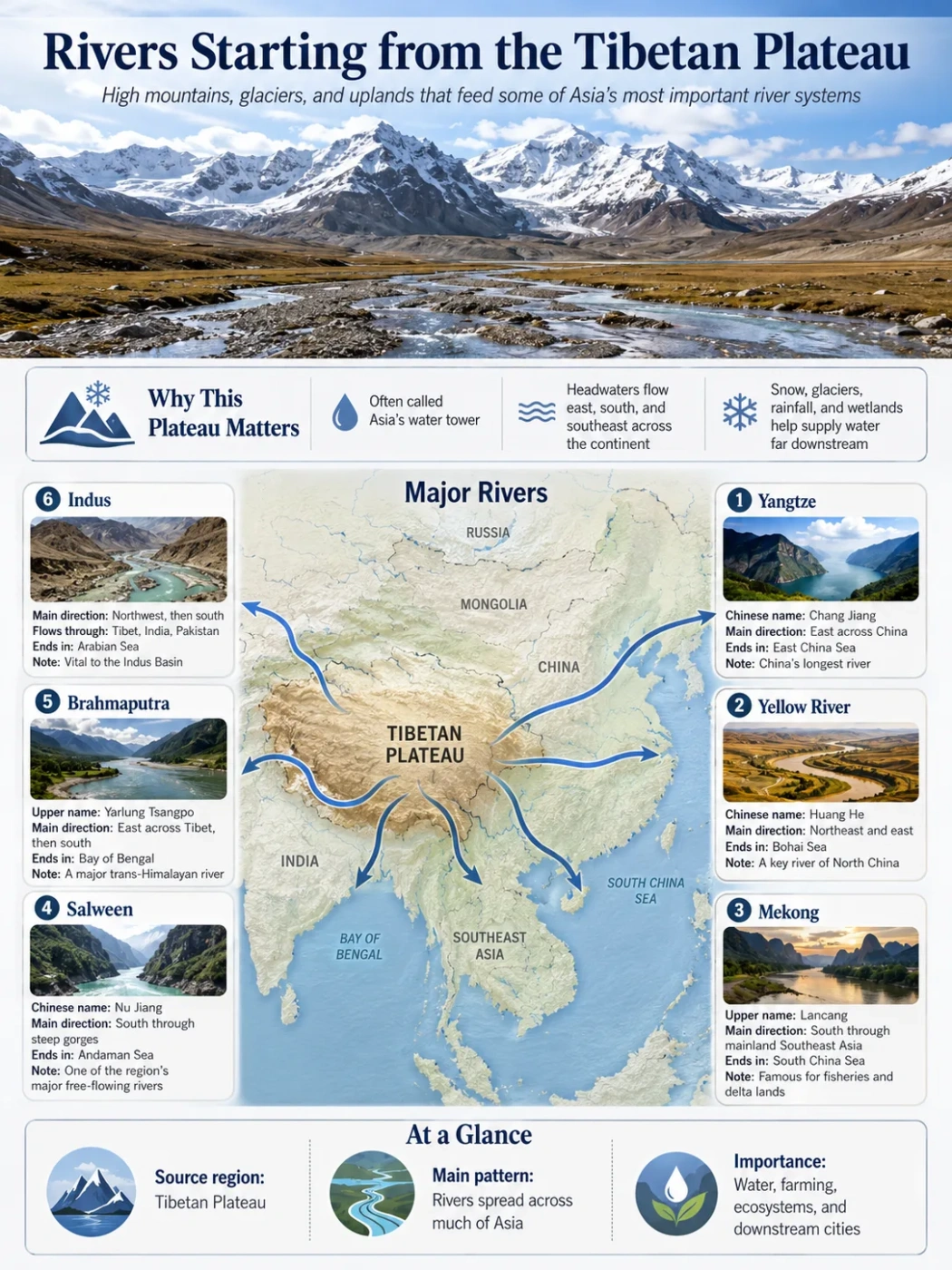
Rivers Reveal the Shape of the Plateaus
Drainage provides one of the best ways to understand western China's relief. The highest plateau regions contain both outward-flowing headwaters and closed inland basins.
- East and southeast: the Yangtze, Yellow, Lancang-Mekong, and Nu-Salween systems begin in or along the Qinghai-Tibet highlands and descend through long valleys.
- South: the Yarlung Zangbo crosses southern Xizang before turning through a deep gorge and continuing as the Brahmaputra.
- West: headwaters connected with the Indus and rivers descending from the Pamir and Kunlun margins carry snow and glacier melt toward lower basins.
- Interior: many Qiangtang, Qaidam, Tarim, Junggar, and Alxa streams end in lakes, marshes, salt flats, alluvial fans, or desert groundwater systems.
- Loess country: dense tributary networks cut soft silt and feed the middle Yellow River.
- Yunnan-Guizhou: short, steep reaches and underground karst drainage divide water among the Yangtze, Pearl, Red, Mekong, and Salween basins.
The contrast between exterior and interior drainage is not controlled by elevation alone. Mountain barriers, basin shape, faulting, climate, and the ability of rivers to cut through a rim all affect whether water reaches the ocean.
Climate and Land Use Change with Height and Moisture
Western China's plateau environments range from cold alpine steppe to humid subtropical karst. Elevation lowers air temperature, but latitude, monsoon reach, mountain rain shadows, and distance from the sea also matter.
Cold Alpine Plateaus
Qiangtang, Hoh Xil, and much of Qinghai have long cold seasons, strong winds, thin air, and short growing periods. Alpine meadow and steppe support grazing where moisture and soils permit. Permanent settlement tends to cluster in broader valleys and lower basins with water, transport routes, and more workable ground.
Dry Interior Plateaus
The Pamir rain shadow, Alxa, and northern Ordos receive limited precipitation. Rangeland, irrigated valley floors, oasis agriculture, and sparse desert vegetation form a patchwork. Water from mountains has an influence far beyond the small area occupied by streams and fans.
Loess Farming Landscapes
The Loess Plateau ranges from semi-arid areas in the northwest to wetter margins in the southeast. Deep silt can form productive soils, but slopes and concentrated summer rain create erosion risk. Farming is concentrated on gentler surfaces, terraces, and valley floors.
Humid Karst Highlands
The Yunnan-Guizhou Plateau receives much more monsoon moisture. Agriculture and cities often occupy basins, valley floors, and flatter upland pockets. Karst creates abrupt changes in soil depth and water availability: rainfall may be ample while surface streams disappear underground.
How to Read These Plateaus on a Physical Map
- Start with elevation bands. The Qinghai-Tibet and Pamir regions usually appear in the highest color class. Lower plateau belts spread north, northeast, and southeast.
- Look for the plateau rim. The Himalaya, Kunlun, Qilian, Karakoram, and Hengduan ranges mark major edges or internal divisions of the high plateau.
- Separate raised surfaces from depressions. Tarim, Junggar, Qaidam, and Sichuan are basins even when surrounded by plateau country.
- Trace river direction. Outward-flowing rivers cut across plateau margins; inland rivers fade into lakes, fans, or desert floors.
- Check map scale. A national map shows parent systems. A provincial or geological map may split the same surface into smaller plateaus, ranges, valleys, and basins.
FAQ About the Plateaus of Western China
What are the main plateaus of western China?
The broad systems are the Qinghai-Tibet Plateau, the Pamir Plateau in far-western Xinjiang, the Loess Plateau, the western part of the Inner Mongolia Plateau, and the Yunnan-Guizhou Plateau. Named subregions include Qiangtang, Qinghai, Hoh Xil, Western Sichuan, Alxa, Ordos, Central Gansu, Northern Shaanxi, Yunnan, and Guizhou.
Is the Tibetan Plateau the same as the Qinghai-Tibet Plateau?
Yes, the names usually refer to the same large physical region. Qinghai-Tibet Plateau and Qinghai-Xizang Plateau make its Chinese geographic extent explicit, while Tibetan Plateau is common in international English.
Which plateau in western China is the highest?
The Qinghai-Tibet Plateau is the highest and largest broad plateau on Earth. Its Qiangtang interior commonly averages around or above 5,000 meters, while mountain summits rise much higher than the plateau surface.
Why are the Tarim and Qaidam not counted as plateaus?
Both are basins. Their floors are enclosed by higher mountains or plateau margins, and much of their drainage stays inland. Qaidam is a high basin within the wider Qinghai-Tibet region, but regional membership does not change its basin landform.
Is the Loess Plateau part of western China?
Its western and northwestern parts clearly lie in western China, while the full plateau extends eastward across north-central China. It is best treated as a transition belt linking the dry northwest with the middle Yellow River region.
Did all of western China's plateaus form in the same way?
No. Crustal collision and uplift dominate the story of the Qinghai-Tibet and Pamir highlands. Windblown silt defines the Loess Plateau. Limestone dissolution shapes much of Yunnan-Guizhou, while desert deposition and erosion influence Alxa and Ordos.
Why do plateau boundaries differ between maps?
Maps may use elevation, slope, bedrock geology, drainage, ecology, or administrative convenience to draw a boundary. Parent plateaus also contain smaller named regions, so a detailed map may show several units where a national map shows one.