INTERACTIVE CONTEXT MAP
Where is Puna de Atacama?
The selected plateau and nearby mapped locations are shown. Open the full world atlas to explore every region.
The Causses are a group of high limestone plateaus in southern France, separated by deep river gorges and underlain by extensive karst drainage systems. Across the southern Massif Central, thick Jurassic carbonate rocks form broad uplands where streams are scarce, sinkholes interrupt the surface, and groundwater emerges from springs along the valleys. The landscape is also shaped by centuries of sheep grazing, dry-stone construction, and farming in the deeper soils of natural depressions.
The Causses of Southern France: Four Plateaus Divided by Gorges
The name causse refers to a limestone plateau characteristic of parts of southern France. The best-known group, the Grands Causses, occupies the southern Massif Central, mainly in Aveyron and Lozère, with related limestone uplands extending into Gard and Hérault. The principal plateau surfaces commonly stand between roughly 700 and 1,200 metres above sea level, although individual plateaus and their margins extend outside that range.
The Grands Causses form a recognizable upland region because they share thick carbonate bedrock, broad elevated surfaces, steep limestone escarpments, and predominantly underground drainage. Their apparent continuity is interrupted by the Tarn, Jonte, and Dourbie rivers, which have cut deep valleys through the rock.
| Plateau | Position | Main Landscape Characteristics |
|---|---|---|
| Causse de Sauveterre | North of the Tarn Gorge | Extensive limestone uplands with open pastures, woodland, cultivated depressions, and karst features. |
| Causse Méjean | Between the Tarn and Jonte gorges | Broad, high plateau surfaces with dry grasslands, cultivated sinkholes, rocky edges, and underground cavities. |
| Causse Noir | Between the Jonte and Dourbie gorges | More wooded limestone uplands, prominent cliffs, and irregular dolomitic rock formations. |
| Causse du Larzac | South of the Dourbie Gorge | A large plateau of pastoral grasslands, karst depressions, dry valleys, and deeply dissected margins. |
Smaller limestone uplands, including the Causses de Sévérac, Comtal, Rouge, and Blandas, contribute to the wider regional landscape. Their geological and geographical relationships differ, so the term Causses does not always describe exactly the same area. The Causses du Quercy, farther west, are another limestone plateau region rather than one of the four principal Grands Causses.
How Jurassic Marine Limestone Became an Elevated Plateau
The foundations of the Grands Causses formed during the Jurassic Period, approximately 201 to 145 million years ago, when much of the region was covered by marine environments. Carbonate sediment accumulated on the seabed, including material derived from marine organisms and chemical precipitation. Over time, burial and cementation turned these deposits into thick sequences of limestone.
Not every layer consists of identical rock. Limestone alternates locally with dolomite and marl, reflecting changes in sedimentation and later chemical alteration. Dolomite is a magnesium-rich carbonate rock, while marl contains a mixture of carbonate and clay. Differences in composition, thickness, and fracturing influence how the rocks weather and transmit water.
Subsequent tectonic movements associated with the evolution of the Massif Central and surrounding mountain systems uplifted and deformed these sedimentary layers. Regional uplift gave rivers greater potential to cut downward, while fractures allowed water to penetrate deeper into the carbonate rock.
The resulting plateau system preserves extensive remnants of elevated sedimentary surfaces. Its deep valleys, cliffs, sinkholes, and cave networks developed through a combination of structural deformation, river incision, weathering, and dissolution over long geological timescales.
Carbonate-rich sediments accumulated in Jurassic marine environments and became thick limestone formations.
Later tectonic deformation raised and fractured the rock, influencing future valley and groundwater development.
Rivers deepened valleys while slightly acidic water enlarged fractures, creating surface and underground karst features.
The Tarn, Jonte, Dourbie, and Vis Gorges
The most striking relief of the Causses occurs where rivers have cut through the elevated limestone. The resulting gorges expose sedimentary beds in nearly vertical walls, sometimes hundreds of metres above the river channels. Their courses also establish the main geographical divisions between the plateaus.
Gorges du Tarn
The Tarn flows between the Causse de Sauveterre to the north and the Causse Méjean to the south. Its gorge contains steep limestone walls, projecting cliffs, narrow river sections, and broader bends where the valley floor provides space for vegetation and settlements.
The river’s incision exposed the layered carbonate rocks and created a marked contrast between the high, relatively dry plateau surface and the more sheltered valley below.
Gorges de la Jonte
The Jonte separates the Causse Méjean from the Causse Noir. Its gorge is bordered by steep rock faces and isolated limestone and dolomite formations. Fractures and variations in bedrock resistance influence the position of cliffs, rock projections, and debris-covered slopes.
These cliffs also provide nesting sites for vultures, connecting the gorge’s geological structure with an important regional wildlife habitat.
Gorges de la Dourbie
South of the Causse Noir, the Dourbie has carved a gorge along the northern side of the Larzac plateau system. The river descends through resistant sedimentary rocks, forming steep walls and narrower valley sections before joining the Tarn near Millau.
The landscape demonstrates how a river can remain active at the bottom of a gorge even where the adjacent plateau has few permanent surface streams.
Gorges de la Vis and Cirque de Navacelles
The Vis River cuts through the southern limestone uplands, particularly around the Larzac and Blandas areas. Near the Cirque de Navacelles, a former river meander was abandoned as the Vis established a shorter course across its loop.
This landform records a different aspect of river erosion: a deeply incised meander can be cut off, leaving the former loop visible within an amphitheatre-like valley setting.
Gorge formation cannot be explained by limestone dissolution alone. Flowing rivers transport sediment and abrade their channels, while uplift, fractures, changes in discharge, and contrasting rock resistance influence how deeply and where a valley develops. Chemical weathering contributes to the process, especially along fractures and within groundwater pathways.
Karst Landforms on the Limestone Surface
Rainwater absorbs carbon dioxide from the air and soil, becoming weakly acidic. As it moves through limestone, it gradually dissolves calcium carbonate. This process widens joints and other openings, allowing more water to penetrate the bedrock.
On the Causses, repeated dissolution and localized collapse have produced a variety of distinctive karst landforms.
Dolines and Sotchs
Dolines are closed surface depressions that commonly develop where limestone dissolves or material moves into underground openings. Locally, some depressions are known as sotchs. They vary from shallow, rounded hollows to larger basins with steeper sides.
Soil and fine sediment often accumulate in these depressions. As a result, a doline may support deeper soils and cultivated fields even when the surrounding plateau is rocky and difficult to farm.
Not every doline forms through sudden ground collapse. Many develop slowly through dissolution and the redistribution of soil over long periods.
Avens, Caves, and Vertical Shafts
An aven is a natural opening or vertical shaft in karst terrain. Water moving downward through fractures can enlarge these passages and connect them with deeper cave networks.
Aven Armand, on the Causse Méjean, is a well-known example of the region’s underground limestone formations. Its large chamber and mineral deposits demonstrate that karst development continues beneath the surface rather than being restricted to visible sinkholes.
Lapies and Exposed Limestone
Exposed limestone may develop grooves, small channels, sharp ridges, and widened joints collectively described as lapies or limestone pavement features. Their patterns depend on water movement, bedding, fractures, and the composition of the rock.
These surfaces show how chemical weathering can transform solid bedrock into finely divided rock shapes without requiring a large surface stream.
Dry Valleys
Some valleys crossing the limestone uplands carry little or no permanent surface flow. They may preserve evidence of earlier drainage conditions, episodic runoff, or the diversion of water into underground karst systems.
A valley that appears dry in ordinary conditions can still convey runoff after intense rainfall. The absence of a permanent stream should not be interpreted as evidence that flowing water never shaped the valley.
Dolomite Rock Cities and Irregular Limestone Relief
In parts of the Causses, weathering has produced clusters of towers, rounded blocks, narrow passages, and rock walls that resemble ruined buildings. These are often called ruiniform or chaos dolomitique landscapes.
Montpellier-le-Vieux on the Causse Noir and Nîmes-le-Vieux on the Causse Méjean are notable examples. Their unusual forms are associated with the structure and weathering behaviour of dolomitic carbonate rocks.
Water penetrates fractures and bedding planes, while physical weathering gradually separates more resistant blocks from surrounding material. Differences in rock composition and fracture spacing help create the uneven pattern of pillars, corridors, and isolated formations.
The name rock city describes the appearance of these formations, not their origin. They are natural geological features shaped through weathering and erosion.
Underground Rivers, Karst Aquifers, and Valley Springs
The drainage pattern of the Causses is strongly controlled by the permeability of fractured limestone. Water entering the plateau through soil, joints, and sinkholes can travel downward into a network of enlarged fractures, conduits, and underground cavities.
Groundwater then moves through the carbonate formations toward springs, often emerging along valley slopes or near contacts between rocks with contrasting permeability. The underground flow routes do not necessarily follow the same pattern as the visible valleys above them.
Water reaches rocky surfaces, thin soils, and closed depressions.
Some water moves rapidly through large openings, while another portion enters smaller fractures and less permeable rock zones.
Karst aquifers temporarily store water and transfer it through connected cavities, fractures, and conduits.
Groundwater reappears at the surface and helps maintain flow in rivers and streams below the plateaus.
Why Some Springs Respond Rapidly to Rain
Large karst conduits can transmit water quickly after heavy rainfall, producing sharp increases in spring discharge. Water held in smaller fractures and less connected storage zones may move more slowly, supporting spring flow during periods without substantial rainfall.
This dual behaviour explains why some springs show strong short-term fluctuations while others continue releasing water after prolonged dry weather.
Why a Dry Plateau Can Have Groundwater Reserves
Water availability at the surface and groundwater storage are different measurements. Dry grass, shallow soil, and the absence of flowing streams do not necessarily indicate that an aquifer has been depleted.
For example, hydrological observations in the Grands Causses during September 2026 found particularly dry surface soils while groundwater levels and spring flows generally remained within their seasonal ranges. Groundwater replenishment from the preceding winter helped support river flow through the dry summer.
Karst aquifers remain vulnerable to prolonged recharge deficits. Because some conduits carry infiltrating water rapidly, contaminants entering exposed limestone or sinkholes may also reach groundwater with limited natural filtration.
Thin Limestone Soils and the Distribution of Grassland and Woodland
Much of the Causses has shallow, discontinuous soil over limestone. Exposed rock, drought-prone slopes, and rapid drainage limit the amount of moisture available to plants in many locations.
Other parts of the plateau have markedly different soil conditions. Depressions accumulate weathered material and finer sediment, sometimes including reddish clay-rich soils associated with limestone terrains and commonly described as terra rossa.
The resulting landscape contains several closely spaced environments:
- Open dry grasslands on exposed and frequently grazed limestone surfaces.
- Scrub and shrub vegetation where grazing has declined or soils support woody growth.
- Woodland on some slopes, plateau margins, and less exposed surfaces.
- Small cultivated areas where deeper soils accumulate in dolines and other depressions.
- Moister vegetation near springs, river corridors, and sheltered valley floors.
The distribution of vegetation is therefore controlled by a combination of bedrock, soil depth, drainage, local climate, slope exposure, and land use.
Sheep Grazing and the Formation of the Open Causses Landscape
The steppe-like appearance of many Causses grasslands reflects a long interaction between natural conditions and pastoral land use. The open landscape is not simply an untouched result of the region’s climate.
Sheep grazing has maintained extensive areas of short vegetation by limiting the establishment of shrubs and young trees. Pastoral activity also influenced the position of tracks, field boundaries, settlements, and water-storage structures.
Lavognes: Small Water Basins on a Permeable Plateau
Because rainwater readily enters the limestone, surface water can be difficult to retain. Communities responded by creating or adapting small water basins known as lavognes, often using naturally occurring depressions and relatively impermeable materials.
These basins supplied water to livestock and also became habitats for amphibians, insects, and other animals. They show how the physical limitations of karst terrain influenced traditional land management.
Dry-Stone Walls, Cisterns, and Cultivated Sinkholes
Local limestone provided material for dry-stone walls, traditional buildings, and some roof structures. Cisterns collected rainwater where reliable surface streams were absent.
Deeper soils in dolines allowed localized cultivation, creating a patchwork of fields within surrounding pasture and exposed rock. The contrast between these small cultivated hollows and the wider grasslands is a direct expression of karst geomorphology.
Transhumance and Seasonal Pastures
Seasonal livestock movement, known as transhumance, linked upland pastures with other grazing areas. Traditional drove routes, called drailles, helped organize movement through the Causses and Cévennes landscape.
Where grazing becomes less frequent, shrubs and woodland can spread into formerly open grassland. This changes the appearance of the plateau and the habitats associated with its long-managed pastoral surfaces.
Plateau Climate, Seasonal Dryness, and Gorge Microclimates
The Grands Causses occupy a climatic transition area influenced by Atlantic, Mediterranean, and continental weather systems. Their elevation exposes plateau surfaces to wind, winter cold, frost, and occasional snow, while summer conditions can be warm and dry.
Rainfall varies with location, season, and topography. A high limestone plateau may receive substantial precipitation without developing a dense network of permanent streams because much of the water infiltrates underground.
Deep gorges introduce additional climatic differences. Valley floors are generally more sheltered from strong plateau winds. Their aspect and depth influence sunlight, temperature, and moisture conditions, creating contrasting habitats between sun-exposed and shaded slopes.
Heavy rainfall can generate rapid runoff and flooding in steep river valleys, even though nearby plateau surfaces normally carry little surface water. The hydrological response depends on rainfall intensity, antecedent moisture, underground storage, and the capacity of the karst drainage network.
Limestone Cliffs, Dry Grasslands, and Vulture Habitats
The steep cliffs of the Tarn and Jonte gorges provide nesting areas for large birds, while the surrounding open plateaus provide extensive foraging space. The combination of cliffs and pastoral grassland has helped support regional vulture conservation.
Griffon vultures were reintroduced to the Grands Causses after their local disappearance. Conservation programmes have also supported other vulture species, including the cinereous vulture and bearded vulture.
Their habitat is closely related to the physical landscape. Cliff ledges provide nesting locations, rising air currents assist soaring flight, and open terrain allows birds to locate food.
Beyond the cliffs, dry grasslands support specialized plant and invertebrate communities. Rock outcrops, woodland edges, sinkholes, and small water basins create additional habitat diversity across relatively short distances.
Causses and Cévennes: The UNESCO Cultural Landscape
The Causses and Cévennes Mediterranean Agro-Pastoral Cultural Landscape was inscribed on the UNESCO World Heritage List in 2011. The designated property covers 302,319 hectares and recognizes a landscape shaped by long-established agricultural and livestock practices.
Its cultural significance is expressed through open grazing land, seasonal livestock routes, settlements, field systems, and traditional approaches to managing scarce surface water.
Geographical Boundary Distinction
The UNESCO property is a defined cultural landscape that includes important parts of the Causses and Cévennes. Its 302,319-hectare area is not the total geological area of all limestone plateaus called the Causses. The Grands Causses Regional Natural Park, Cévennes National Park, and the World Heritage property also have different boundaries and management arrangements.
The UNESCO designation recognizes the relationship between pastoral communities and their physical environment. The limestone geology provides the setting, while the cultural landscape includes the land-use practices that developed within it.
Water, Erosion, and Landscape Change in the Causses
The future physical character of the Causses depends partly on how its karst water resources respond to changing rainfall patterns. Extended dry periods can reduce groundwater recharge, while intense rainfall may increase rapid conduit flow, slope erosion, and flooding in confined valleys.
Karst aquifers require particular attention because a change in groundwater level or chemistry can affect springs far from the original recharge area. Surface drainage divides do not always correspond to underground groundwater boundaries.
The open grassland landscape is also sensitive to changing grazing patterns. Shrub expansion, woodland regeneration, soil erosion, and changes in the management of small water basins can alter the ecological and visual character of the plateau.
On steep gorge walls, rockfalls and weathering continue to modify the limestone cliffs. These processes operate alongside the slower dissolution and underground drainage changes that remain active throughout the Causses.
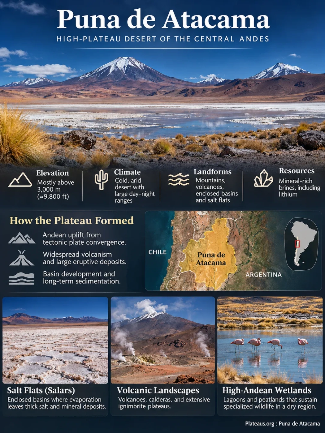
The Puna de Atacama is an arid high-plateau region of the Central Andes, extending across northwestern Argentina and adjoining highlands of Chile. Its terrain is formed by elevated mountain ranges, volcanic complexes, enclosed sedimentary basins, salt flats, and scattered high-altitude wetlands. Much of the region lies above 3,000 metres, with numerous basin floors and upland surfaces approaching or exceeding 4,000 metres, while surrounding volcanic mountains rise considerably higher. The combination of tectonic uplift, limited drainage, and long-term evaporation has produced one of the most distinctive high-desert plateau landscapes in South America.
The Puna de Atacama Within the Central Andes
The Puna de Atacama belongs to the southern part of the broader Altiplano–Puna plateau system. This elevated region extends along the Central Andes and is characterized by thickened continental crust, high average elevation, and mountain ranges separated by sediment-filled basins.
In northwestern Argentina, areas associated with the Puna de Atacama include highlands of Salta, Catamarca, and parts of Jujuy. The geographical name also has a historical association with the borderlands of northern Chile and Argentina. Its limits vary according to whether it is used in a historical, physiographic, or regional geological sense.
The southern Puna is not a single level plain. It consists of basin floors, mountain ridges, volcanic cones, lava fields, and extensive deposits of ash and other volcanic material. Differences of hundreds or thousands of metres may occur between neighbouring basin floors and summits.
Puna de Atacama and Salar de Atacama Are Different Landforms
The name can cause confusion with the Salar de Atacama in northern Chile. The Salar de Atacama is a salt flat in a lower enclosed basin near San Pedro de Atacama, at approximately 2,300 metres above sea level. The Puna de Atacama refers to the much broader highland plateau region, including mountainous terrain and numerous separate basins.
Water from some high Andean catchments contributes to the hydrological system of the lower Salar de Atacama, but this connection does not make the two geographical features identical.
Puna de Atacama
- High-plateau region with multiple mountain and basin systems.
- Generally situated above 3,000 metres.
- Includes volcanic highlands, salars, and high-altitude wetlands.
- Extends across a broad region rather than one drainage basin.
Salar de Atacama
- Individual salt flat and associated closed basin in Chile.
- Salt-flat surface at approximately 2,300 metres.
- Contains extensive evaporite deposits and saline groundwater.
- Receives groundwater and runoff from surrounding mountain catchments.
Why the Puna Is a High Plateau of Mountains and Basins
The elevation of the Altiplano–Puna system is associated with the convergence of the Nazca and South American tectonic plates. The oceanic Nazca Plate moves beneath South America, driving deformation and magmatism along the Andean margin.
Over millions of years, crustal shortening and thickening raised broad areas of the Central Andes. Faulting and deformation produced mountain ranges and intervening depressions. Magma rising through the crust formed volcanic mountains and extensive deposits of lava, ash, and ignimbrite.
Geological research indicates that the Altiplano and Puna did not acquire their present elevations through a single uplift event. Different sectors experienced deformation and uplift at different times, with the main development of the high plateau extending through the Cenozoic Era.
In the southern Puna, many mountain ranges trend approximately north–south. These ranges divide the landscape into separate sedimentary basins. Volcanic chains and fault-controlled uplifts create further barriers that influence the movement of water and sediment.
This basin-and-range topography explains why the Puna can be classified as a plateau despite its rugged relief. Its broad regional elevation is high, even though much of its surface consists of mountains and depressions rather than continuous flat terrain.
Closed Basins and the Formation of High-Altitude Salt Flats
Many valleys of the Puna de Atacama form endorheic basins, meaning that their surface drainage does not reach the ocean. Streams descending from the surrounding mountains terminate within enclosed depressions, where water infiltrates the ground, collects temporarily, or evaporates.
Minerals released through rock weathering enter these basins as dissolved ions. With no permanent external river outlet, repeated cycles of water input and evaporation allow dissolved salts to accumulate.
Over long periods, lake sediments, river deposits, windblown material, volcanic ash, and evaporite minerals build up thick sequences beneath the basin floors. The modern salt crust is often only the uppermost visible expression of a much deeper sedimentary system.
Formation of an Enclosed Basin
Tectonic deformation and mountain uplift establish a low-lying area without a permanent surface outlet to the sea.
Delivery of Water and Dissolved Minerals
Runoff, groundwater, and occasionally hydrothermal fluids transport dissolved ions and sediments toward the basin floor.
Evaporation and Mineral Precipitation
Water loss concentrates dissolved substances. Different minerals precipitate as the chemical composition of the remaining water changes.
Development of Salt Crusts and Brine Aquifers
Evaporite layers accumulate, while saline groundwater may remain stored in pores and fractures within the underlying sediments.
Halite, the mineral form of sodium chloride, commonly forms major parts of salt-flat deposits. Gypsum, borate minerals, carbonates, and other evaporites occur under different geological and geochemical conditions.
Not every Puna basin becomes a continuous white salt pan. Some retain seasonal lakes, saline lagoons, mudflats, or alternating sediment and evaporite surfaces. Their appearance depends on the balance between water supply, evaporation, groundwater movement, and sediment deposition.
The Principal Salt Basins of the Southern Puna
The Puna de Atacama and adjacent southern Puna contain numerous named salt flats. These basins differ in size, elevation, geological history, and groundwater chemistry. Several of the most prominent are located in the Argentine provinces of Salta and Catamarca.
| Salt Flat | Location | Geographical Characteristics |
|---|---|---|
| Salar de Arizaro | Salta | Large enclosed basin with a thick salt core, former lake deposits, and volcanic features along its margins. |
| Salar de Antofalla | Catamarca | Elongated salt basin bordered by mountains and associated with tectonic and volcanic structures. |
| Salar del Hombre Muerto | Catamarca and Salta | Evaporite basin containing lithium-bearing brines, groundwater transition zones, and nearby freshwater-dependent environments. |
| Salar de Pocitos | Salta | High enclosed basin with saline deposits, surrounding sedimentary surfaces, and groundwater resources. |
| Salar de Pastos Grandes | Salta | Salt-bearing basin influenced by mountain runoff, sediment deposition, and evaporative concentration. |
| Salar de Pozuelos | Salta | Smaller saline basin within the broader Puna basin system, with mineralized groundwater and evaporite sediments. |
Salar de Arizaro: A Large Salt Flat With an Ancient Lake History
Salar de Arizaro lies at approximately 3,475 metres above sea level and covers roughly 1,700 square kilometres under a commonly used geological estimate. It is among the largest salt flats of the Central Andes.
The basin contains a substantial halite deposit and sediments derived from ancient lakes, streams, and wind-driven processes. Satellite observations have identified former shoreline features, indicating that the basin experienced wetter conditions during parts of its history.
Wind-shaped hills, known as yardangs, occur in parts of the surrounding terrain. These features form where persistent winds erode comparatively soft material, leaving elongated residual landforms.
Cono de Arita, a conspicuous conical hill rising from the salt-flat landscape, is another notable landform. Its shape should not be taken as proof that it is an ordinary young volcanic cone; its geological origin requires consideration of the local rock structure and erosional history.
Salar de Antofalla: A Long, Mountain-Bounded Basin
Salar de Antofalla is distinguished by its elongated shape and position between elevated mountain and volcanic systems. Its geometry reflects the structural organization of the southern Puna, where deformation created long depressions aligned with regional mountain ranges.
Different parts of the basin contain salt deposits, fine sediment, and surfaces shaped by intermittent water movement. The surrounding mountains supply sediment and dissolved minerals that contribute to the basin’s long-term evolution.
Salar del Hombre Muerto: Salt Deposits and Groundwater Resources
Salar del Hombre Muerto is a major lithium-bearing basin. Beneath portions of its surface, dense saline groundwater occupies porous evaporite and sedimentary layers.
The basin also contains or adjoins areas where fresher groundwater moves from surrounding highlands toward the salar. Understanding these flow paths is necessary for interpreting groundwater storage, mineral concentration, and the environmental behaviour of nearby wetlands.
Volcanoes, Calderas, and Ignimbrite Plateaus
Volcanism is a defining part of the Puna’s geological structure. Magma associated with Andean subduction has produced stratovolcanoes, lava domes, cinder cones, broad volcanic deposits, and large caldera systems.
Many of these features developed during the Neogene and Quaternary periods. Their deposits cover older rocks, fill pre-existing depressions, and create local elevated surfaces that later become dissected by erosion.
Cerro Galán: A Large Explosive Volcanic Complex
The Cerro Galán complex in Catamarca is one of the southern Puna’s major volcanic systems. Large explosive eruptions produced extensive ignimbrites, which are deposits formed primarily by hot, fast-moving mixtures of volcanic particles and gas.
Major Galán ignimbrite eruptions occurred around 2.1 million years ago, with geological dating identifying closely spaced events within the broader eruptive sequence. The total erupted material was enormous, extending across a large part of the surrounding high plateau.
The caldera system formed through volcanic collapse and subsequent deformation. It demonstrates how large eruptions can reshape wide plateau areas rather than only building isolated volcanic mountains.
Cerro Blanco: Explosive Volcanism During the Holocene
The Cerro Blanco Volcanic Complex, also in Catamarca, contains nested caldera structures, volcanic domes, and widespread pyroclastic deposits.
A major explosive eruption occurred approximately 4,200 years ago. Geological evidence records extensive ash fallout and pyroclastic flows, making this one of the notable Holocene explosive volcanic events in the Central Andes.
The event illustrates that some of the Puna’s volcanic features developed relatively recently in geological terms. The region’s volcanic history includes multiple eruptive episodes of different ages, rather than one continuous episode of mountain building.
Stratovolcanoes and Smaller Volcanic Centres
High volcanic mountains, including the Antofalla volcanic system, stand above adjoining basin floors. Their steep slopes, lava deposits, and volcanic debris influence drainage routes and sediment delivery.
Smaller volcanic centres also occur around salars such as Arizaro. Basaltic to intermediate volcanic rocks may form cones, short lava flows, and isolated volcanic hills, adding further relief to the basin margins.
Campo de Piedra Pómez: Pumice Deposits Sculpted by Wind
Campo de Piedra Pómez, near El Peñón in Catamarca, is a landscape of light-coloured volcanic rock formed from pumice-rich eruptive deposits associated with the Cerro Blanco volcanic system.
Pumice develops when gas-rich magma expands rapidly during explosive eruptions. The resulting volcanic material contains abundant cavities and may be much less dense than ordinary solid rock.
At Campo de Piedra Pómez, extensive deposits have been modified by wind erosion, producing ridges, narrow passages, rounded surfaces, and isolated rock forms. Differences in rock texture and resistance influence how quickly individual features wear away.
The area’s principal pumice-bearing ignimbrite deposits include material from Pleistocene eruptive activity. They should not all be attributed automatically to Cerro Blanco’s later eruption around 4,200 years ago.
This distinction is important because the present landscape combines volcanic deposition from multiple events with subsequent erosion. The unusual rock forms are the product of both processes.
Why the Puna Is a Cold, Arid Desert at High Elevation
The Puna de Atacama lies within one of the driest high-altitude regions of the Andes. Its aridity reflects mountain barriers, regional atmospheric circulation, and limited moisture transport into the interior basins.
The Andes influence the movement of humid air from the east, while the western side of the region is closely associated with the dry atmospheric conditions of the Atacama Desert. Rainfall varies considerably across the plateau, and eastern or more elevated areas may receive greater seasonal precipitation than the driest western basins.
Much of the rainfall occurs during the austral summer, although local precipitation patterns differ. In parts of the southern Puna, annual totals can remain below approximately 130 millimetres, but this figure should not be applied uniformly across the entire region.
Low Air Pressure and Strong Solar Radiation
At elevations near 4,000 metres, atmospheric pressure is substantially lower than at sea level. The thinner atmosphere is associated with reduced oxygen availability and strong exposure to solar radiation, including ultraviolet radiation.
These conditions affect weathering, evaporation, vegetation, and the physical environment of exposed upland surfaces.
Large Day–Night Temperature Differences
Dry air and limited cloud cover allow strong daytime solar heating, followed by rapid heat loss after sunset. Large temperature changes between day and night are common, and freezing temperatures can occur even when daytime conditions are relatively mild.
Repeated freezing and thawing contribute to the breakdown of exposed rocks where moisture enters cracks and expands during freezing.
Wind and Surface Erosion
Strong winds can remove fine sediment from dry lake beds and exposed volcanic deposits. Dust transport, deflation surfaces, and wind-carved rock features are common expressions of this process.
The effectiveness of wind erosion depends on the amount of loose material, surface moisture, vegetation cover, and the resistance of the underlying rock.
Water Movement in a Desert Without an Ocean Outlet
Although permanent rivers are scarce across much of the Puna, water continues to shape the plateau. Mountain rainfall, seasonal runoff, snowmelt, and groundwater discharge supply enclosed basins at different rates.
Some streams flow only briefly after precipitation, carrying sediment from volcanic slopes and mountain valleys into the lower basin floors. Coarser sediment accumulates near mountain fronts as alluvial fans, while finer material reaches playas, wetlands, and salt-flat margins.
Where streams terminate in an enclosed depression, water may form temporary lakes or infiltrate into the sediment. Evaporation removes water from the system while leaving most dissolved minerals behind.
Subsurface drainage introduces additional complexity. Groundwater may move between connected sedimentary units or along fractures, and some basin systems include smaller compartments separated by less permeable rocks or structural barriers.
For this reason, a closed surface drainage basin does not necessarily mean that every underground water body is completely isolated. The extent of groundwater connectivity must be established for each basin.
Hydrological Distinction
A salar is not simply a dry lake with salt on its surface. Many salars contain groundwater stored within thick layers of halite, sand, gravel, clay, and other sediment. The chemical composition and movement of this groundwater can differ sharply between the salt-flat centre and its margins.
Freshwater, Saline Groundwater, and Lithium-Rich Brines
The Puna’s mineral-rich groundwater develops through prolonged interactions among water, volcanic and sedimentary rocks, dissolved minerals, and evaporation.
Rainwater and snowmelt entering the highland catchments may initially have relatively low salinity. As groundwater moves through rock and sediment, it acquires dissolved substances. Water that remains within closed basins can become more concentrated through repeated evaporation and chemical interaction.
Some resulting brines contain elevated lithium concentrations. Potential lithium sources include weathered volcanic rocks and hydrothermal systems, although the relative contributions of different sources vary among basins.
The Difference Between Freshwater and Brine
Dense brine can occupy pore spaces beneath the salt-flat centre, while less saline groundwater occurs in marginal sedimentary units and alluvial fans. Transition zones develop where these waters meet or interact.
Density differences, hydraulic gradients, geological barriers, and sediment permeability control the movement of these fluids. The transition is not necessarily a simple, continuous boundary across the entire salar.
Why Lithium Concentrations Vary Between Salars
Lithium enrichment depends on several geological and hydrological conditions: the composition of source rocks, the history of groundwater circulation, basin age, evaporation, mineral precipitation, and the availability of porous sediments for brine storage.
Regional studies of southern Puna salars have identified substantial variation in lithium concentrations and lithium-to-magnesium ratios. A large white salt crust therefore does not automatically indicate a high concentration of economically recoverable lithium.
High-Altitude Lagoons, Wetlands, and Local Water Supply
Scattered wetlands form some of the most important water-dependent environments in the Puna de Atacama. They occur near springs, streams, lake margins, and areas where groundwater reaches the surface.
High-altitude wetlands known locally as vegas and bofedales can support dense vegetation compared with the surrounding dry ground. Their persistence often depends on groundwater discharge or seasonal water supply.
Lagoon salinity varies widely. Some water bodies contain relatively fresh water, while others are strongly saline and alkaline. Differences in chemistry and water depth influence the organisms that can survive in each environment.
Flamingos use suitable high Andean lagoons as feeding habitats, supported by microorganisms and small aquatic organisms. The distribution of these birds depends on local water availability, food resources, and the chemical conditions of individual wetlands.
Salt-tolerant microbial communities also occur in some of the region’s saline waters and sediment surfaces. Their survival reflects adaptations to strong solar radiation, large temperature changes, and high mineral concentrations.
Because many wetlands occupy small areas within otherwise dry basins, changes in spring flow or groundwater levels can affect them disproportionately. Their ecological condition cannot be understood from annual precipitation alone.
Former Lakes and Evidence of Wetter Periods
Today’s dry basins preserve evidence that water conditions have changed over time. Abandoned shorelines, lake sediments, mineral deposits, and old stream terraces reveal periods when individual basins contained more extensive surface water.
At Salar de Arizaro, former shoreline features visible in satellite observations document stages when lake water occupied a larger area than today.
In the Antofagasta de la Sierra region, geological and archaeological studies have also recorded changes in rivers, wetlands, and human use of water resources during the Holocene. These records show that even relatively small changes in climate and groundwater conditions can alter the distribution of habitable and productive environments in a high desert.
Not all salars share the same lake history. Their responses depend on basin depth, catchment size, water inflow, evaporation, and the timing of tectonic and volcanic changes.
Lithium Extraction and the Hydrology of the Puna Basins
Lithium-bearing brines have made several southern Puna basins important areas for mineral extraction. The geological resource occurs in groundwater systems, so production methods are directly connected to basin hydrology.
Conventional extraction commonly involves pumping brine from subsurface deposits and concentrating dissolved minerals through evaporation ponds before further processing. Direct lithium extraction methods use separation processes to recover lithium from brine without relying on the same extensive sequence of solar evaporation ponds.
Neither approach can be assumed to have no effect on local water resources. Freshwater requirements, brine withdrawal rates, reinjection practices, and the position of wells all influence the potential hydrological response.
At Salar del Hombre Muerto, industrial lithium development includes the Sal de Oro project. A second lithium carbonate plant was inaugurated in October 2026 with an announced design capacity of approximately 23,000 tonnes per year. That figure represents planned production capacity rather than an established annual output.
Hydrological research on closed Andean basins has shown that freshwater withdrawals can reduce groundwater discharge toward wetlands. Brine pumping may also affect nearby freshwater systems, depending on the position of extraction wells and the geological connectivity between aquifers.
Reliable assessment therefore requires basin-specific measurements of groundwater levels, hydraulic conductivity, recharge, fluid density, and wetland discharge. Production volume alone is not sufficient to determine the impact on a salar’s water balance.
Puna de Atacama and the Wider Altiplano–Puna System
The Puna de Atacama forms part of the broader elevated Andean region, but its basin-and-range topography, dry climate, and volcanic features give it a recognizable southern character.
Northward, the Altiplano includes extensive high basins and major lake systems, particularly across Bolivia and Peru. Southward, the Puna becomes more strongly divided into separate mountain ranges and enclosed sedimentary depressions.
Neither boundary is a single abrupt landform. The transition involves changes in topography, volcanic history, drainage, and climate across a continuous highland system.
| Region | Characteristic Relief | Water and Surface Features |
|---|---|---|
| Altiplano | Broad high-elevation basins bordered by major Andean ranges. | Large lake basins, salt flats, rivers, and internal drainage networks. |
| Puna de Atacama | High mountain ranges, volcanic complexes, fault-controlled depressions, and elevated basin floors. | Numerous enclosed salars, ephemeral streams, groundwater systems, and isolated wetlands. |
| Lower Atacama Desert | Lower desert basins, mountain slopes, intervening ranges, and extensive arid surfaces. | Very limited rainfall in many areas, groundwater-fed environments, and saline depressions. |
The distinction is useful when comparing plateau elevations or landform types. A high salt flat in the Argentine Puna, a lake basin on the Bolivian Altiplano, and the lower Salar de Atacama in Chile may share evaporite processes, but they occupy different physiographic and hydrological settings.
Landscape Sensitivity: Wetlands, Salt Crusts, and Groundwater Recharge
The Puna’s landforms respond to environmental changes at different timescales. Wind erosion and occasional flood events can alter exposed surfaces rapidly, while the development of thick evaporite deposits and deep groundwater systems occurs over much longer periods.
Wetlands may be particularly sensitive to changes in groundwater discharge because they depend on relatively small but persistent water supplies. Regional climate studies have documented rising temperatures and changes in precipitation across parts of the high Andean plateau, although trends and hydrological responses are not identical in every basin.
Salt crusts, volcanic ash deposits, and fine-grained playa sediments can also be disturbed by surface traffic, erosion, or changes in moisture conditions. Their recovery depends on continuing sediment supply, wind activity, and the local water balance.
Long-term groundwater recharge remains difficult to quantify in many basins because measurements are sparse and subsurface pathways can be complex. Differences in basin structure mean that observations from one salar cannot automatically be transferred to another.
The plateau’s present geography continues to evolve through tectonic activity, volcanic processes, mineral weathering, sediment transport, groundwater movement, and evaporation. These processes operate together but at very different rates across the mountains, basins, and salt-flat surfaces of the Puna de Atacama.