INTERACTIVE CONTEXT MAP
Where is Altiplano?
The selected plateau and nearby mapped locations are shown. Open the full world atlas to explore every region.
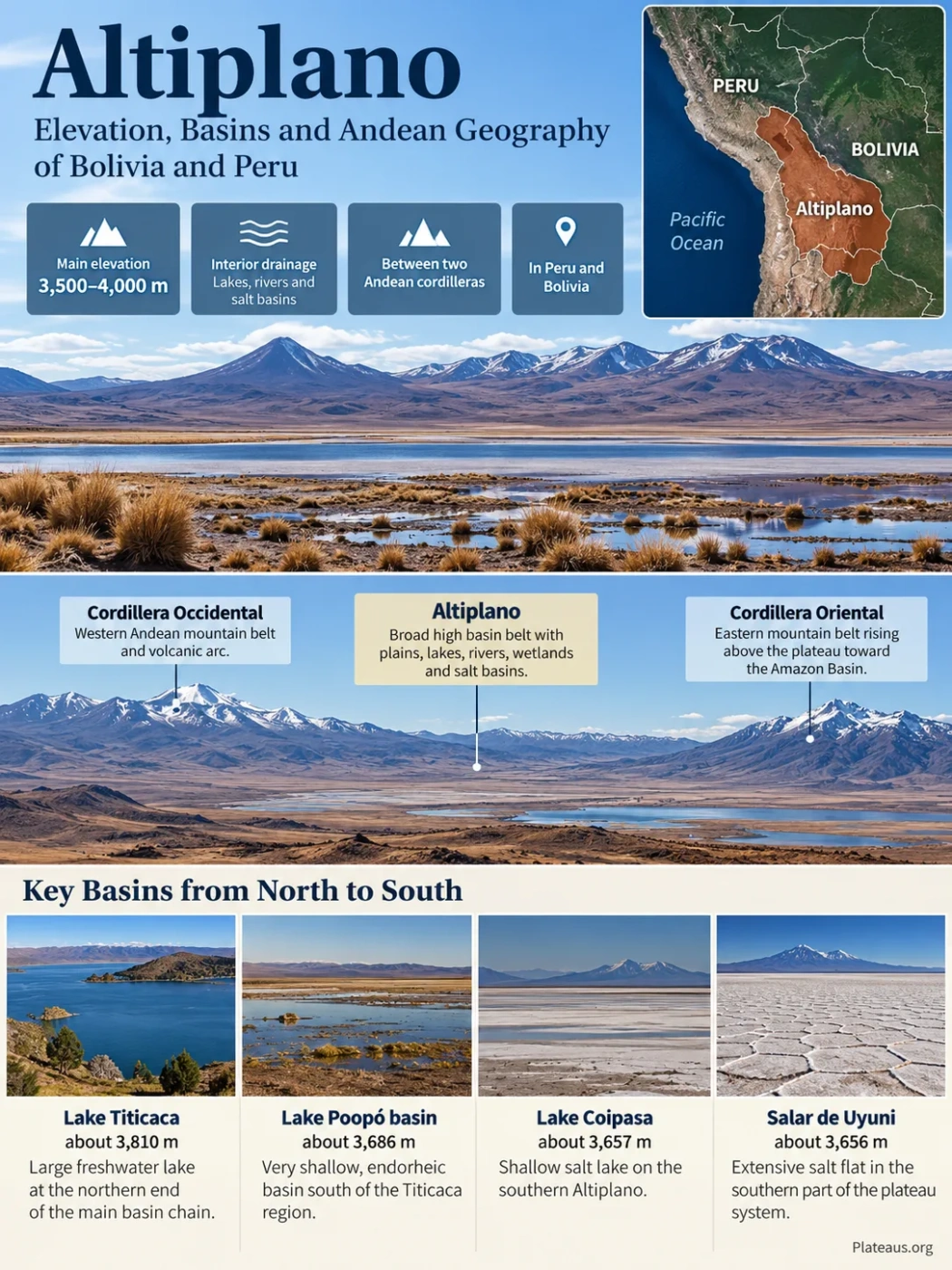
The Altiplano is a broad highland basin system in the Central Andes, centered on southern Peru and western Bolivia between the Cordillera Occidental and the Cordillera Oriental. Much of its plateau surface lies roughly 3,500–4,000 metres above sea level, yet the land is not a single level plain. Lake basins, sediment-filled flats, low mountain blocks, volcanic terrain and salt pans create a stepped interior landscape in which water moves from the Titicaca basin toward progressively lower and drier basins to the south.
Mostly 3,500–4,000 m
Interior drainage
Peru and Bolivia
A High Basin Between Two Andean Cordilleras
The Altiplano occupies the broad interior of the Central Andes where the mountain system separates into major western and eastern belts. The Cordillera Occidental forms the western side, marked by a long volcanic chain. The Cordillera Oriental, including the Cordillera Real in Bolivia, rises along the eastern side. Between them lies a high area hundreds of kilometres across in places.
Western Andean mountain belt and volcanic arc, separating much of the plateau from the Pacific side of the Andes.
Broad high basin belt containing plains, lakes, rivers, wetlands, internal ridges and salt basins.
Eastern mountain belt rising above the plateau before the Andes descend toward the humid eastern slopes and Amazon Basin.
In Peru, the best-known Altiplano landscape surrounds Lake Titicaca and Puno. Peru’s national geographic description places the northern Altiplano near an average elevation of about 3,800 m and parts of the central and southern high surface above 4,000 m. Across the border in Bolivia, the plateau broadens into the La Paz–Oruro highlands and continues south through the Poopó, Coipasa and Uyuni basins.
The international boundary does not divide two separate landforms. Lake Titicaca itself crosses the Peru–Bolivia border, and the surrounding topography forms a continuous high Andean basin. National names and administrative boundaries are useful for locating places, but the physical geography follows mountain belts, drainage divides and basin floors.
Altiplano, Altiplano–Puna and Puna
Altiplano usually refers most directly to the high plateau and basin region of Peru and Bolivia. Altiplano–Puna Plateau is a broader scientific term for the high Central Andean plateau extending farther south. Puna may describe the southern high plateau, a high-elevation ecological zone, or a regional landscape depending on context. The terms overlap, but they are not exact synonyms.
Elevation Changes Across a Surface That Looks Flat
Calling the Altiplano a plateau can create the impression that its surface has one characteristic elevation. It does not. The broad highland stands several kilometres above sea level, while individual basin floors descend gradually from the Titicaca region toward the salt basins of southwestern Bolivia. At the same time, mountain ranges and volcanoes rise thousands of metres above those floors.
The difference between plateau elevation and summit elevation matters. Peaks above 6,000 m around the Altiplano are part of its mountainous margins or internal relief; they do not mean that the plateau surface itself stands at 6,000 m.
| Basin or Surface | Approximate Elevation | Physical Character |
|---|---|---|
| Lake Titicaca | about 3,810 m | Deep, large freshwater lake at the northern end of the main basin chain |
| Lake Poopó basin | about 3,686 m | Very shallow, saline and highly variable lake basin |
| Salar de Coipasa | about 3,656 m | Salt basin receiving local runoff and, under wet conditions, water from farther north |
| Salar de Uyuni | about 3,653 m | Vast terminal salt-flat basin in the southern Bolivian Altiplano |
These figures are best read as reference elevations rather than fixed water levels. Lake surfaces fluctuate, and the shallow Poopó basin can change dramatically in both depth and area. The pattern is more important than a metre-by-metre comparison: over several hundred kilometres, the interior basin floors step downward toward the south.
That modest gradient is enough to influence drainage. Lake Titicaca stands roughly 120 m above the Poopó basin, while the southern salt flats sit only a few tens of metres below Poopó. Water therefore does not rush down a steep valley system. It crosses an unusually high, low-gradient interior landscape where evaporation can remove much of it before it reaches the next basin.
Why the Altiplano Is So High
The Altiplano is part of an Andean mountain system built above the subduction zone where the oceanic Nazca Plate descends beneath South America. Its elevation cannot be explained by a single volcanic episode or by one block of crust simply being lifted upward.
Long-term compression shortened and thickened the continental crust of the Central Andes. Thicker crust helped raise the region to high elevation.
As Andean ranges rose, broad depressions developed between mountain belts. Rivers and lakes delivered sediment into these enclosed and partly enclosed basins.
Magma added material within the crust, while repeated volcanic activity reshaped the western and southern margins of the plateau.
Modern geological studies describe Central Andean plateau growth as a multi-stage process. Different parts of the Altiplano rose at different times and rates as shortening, crustal thickening, magmatism, movement within the lower crust and changes in the dense lower lithosphere interacted over millions of years. Much of the present high topography developed through episodes from the Oligocene and Miocene into the Pliocene rather than during one uniform uplift event.
This history also explains why the Altiplano contains broad sedimentary plains instead of being a continuous mass of sharp mountain ridges. Material eroded from rising ranges accumulated in interior depressions. Lake beds, river deposits, alluvial sediments and volcanic material progressively filled low areas, producing extensive high surfaces between the surrounding mountains.
The Western Margin Is More Volcanic Than the Basin Interior
The Cordillera Occidental follows the active volcanic arc above the Andean subduction zone. Volcanoes and volcanic deposits therefore dominate many western and southwestern landscapes, especially toward Bolivia and northern Chile. The broad interior Altiplano, however, is better understood as a tectonically elevated basin-and-plateau system with large sediment-filled depressions. Calling the entire Altiplano simply a volcanic plateau would hide that distinction.
The Altiplano Forms a Staircase of Interior Basins
One of the clearest ways to understand the Altiplano is to follow its water southward. Much of the plateau has endorheic drainage: water drains toward interior lakes and salt basins rather than reaching the ocean. The result is a linked but uneven chain in which permanent connections, temporary overflows and closed terminal basins occur within the same highland.
The deep northern reservoir, near 3,810 m, stores a large volume of relatively fresh water.
Titicaca’s surface outlet carries water south when the lake stands above its outlet sill.
A broad but very shallow basin where evaporation has a much stronger effect on water area and salinity.
A lower salt basin that can receive overflow from the Poopó system during sufficiently wet periods.
The neighboring southern terminal basin, connected with Coipasa during major floods and much larger lake phases in the past.
Lake Titicaca Stores Water at the Top of the System
Lake Titicaca occupies the northern, wetter part of the Altiplano. Its mean surface is near 3,810 m, its area is roughly 8,500–8,600 km² depending on water level and measurement method, and its deepest water reaches about 280 m. That depth gives Titicaca far more storage than the shallow basins farther south.
The lake has a surface outlet through the Río Desaguadero, but only a small portion of its water balance normally leaves that way. Evaporation accounts for most water loss. This is why relatively small shifts in rainfall and evaporation can strongly affect whether water reaches the downstream river.
Desaguadero Carries the Overflow South
The Río Desaguadero leaves the southern part of Lake Titicaca and runs roughly 300 km toward the central Bolivian Altiplano. The river does more than transfer lake water. Tributaries and local runoff join it along the way, so its discharge and chemistry can differ markedly by the time it approaches Lake Poopó.
The river also demonstrates how the Altiplano combines connected and closed drainage. Titicaca has an outlet under suitable lake levels, yet the larger basin system still ends inland. Water entering the southern basins is ultimately lost mainly through evaporation rather than through a river reaching the Pacific or Atlantic.
Lake Poopó Is Broad but Extremely Shallow
Lake Poopó occupies a basin near 3,686 m. Its average depth has commonly been only a few metres, so a relatively small vertical change in water level can expose or inundate a very large area of the nearly flat basin floor.
This geometry makes Poopó far less stable than Titicaca. The lake nearly disappeared in 2015 after severe water loss. Drought, high evaporation, reduced inflow and water withdrawals for irrigation and mining have all affected the basin. Later water returns do not make Poopó equivalent to a deep permanent lake; expansion and contraction are normal features of its shallow setting, with extreme dry periods pushing that variability much farther.
Where the TDPS System Ends
The formally named TDPS system consists of Lake Titicaca, the Río Desaguadero, Lake Poopó and Salar de Coipasa. Salar de Uyuni belongs to the wider southern Altiplano basin system but is not the “S” in TDPS. Coipasa and Uyuni lie so close in elevation that they can become hydrologically connected during major floods and were repeatedly joined during large paleolake phases.
Why Freshwater Gives Way to Salt Toward the South
The sequence from Titicaca to Poopó, Coipasa and Uyuni is also a climatic gradient. The northern Altiplano receives much more moisture than the southern salt-flat region. Around the Titicaca basin, annual precipitation can reach roughly 800–1,000 mm in wetter areas. Near Salar de Uyuni, some areas receive less than 100 mm in a year.
Rainfall is strongly seasonal. Across much of the Bolivian Altiplano, more than four-fifths of annual precipitation falls during the austral summer, largely from December through March. Moisture reaching the Central Andes is strongly tied to circulation from the east and the South American summer monsoon. The long dry season leaves evaporation operating for months with little replacement rainfall.
More rainfall, permanent tributaries, deep Lake Titicaca and broader wetland environments.
Lower rainfall, shallow Lake Poopó, saline soils and strong sensitivity to changes in inflow.
Very low rainfall, high evaporation, intermittent surface water and extensive salars.
Closed Drainage Keeps Dissolved Minerals Inside
Rain and snowmelt weather volcanic rocks, sedimentary deposits and other exposed materials, carrying dissolved ions into the basins. In an open river system, part of that dissolved load can eventually reach the ocean. In an endorheic basin, there is no such exit.
Water evaporates while dissolved material remains behind. Repeated cycles of inflow, flooding, concentration and drying progressively enrich terminal basins in salts. This is why the southern Altiplano can shift from shallow saline water to exposed evaporite crust over comparatively short distances.
The progression is not a simple linear transformation of Titicaca water into Uyuni salt. Local rivers, groundwater, rainfall, volcanic geology and individual drainage divides also matter. The north-to-south pattern works because several neighboring basins share a broad climatic and topographic gradient, not because one continuous river flows through every basin.
High Elevation Produces Large Daily Temperature Swings
Altitude also shapes the plateau’s climate. Thin, dry air and strong solar radiation can warm exposed ground rapidly during the day, while dry conditions allow rapid heat loss after sunset. Frost can occur even where daytime sunshine feels intense. The result is a landscape defined less by permanently low daytime temperatures than by cold nights, frequent frost and large day-to-night temperature ranges.
Lake Titicaca moderates conditions close to its shores because water heats and cools more slowly than dry ground. That local effect helps distinguish the Titicaca basin from equally high but drier interior surfaces farther from the lake.
Ancient Lakes Explain the Modern Salt Flats
Salar de Uyuni and Salar de Coipasa are often described simply as the beds of vanished lakes. Their history is more complex. The central and southern Altiplano repeatedly shifted between wetter and drier states, producing multiple generations of lakes rather than one lake that dried once and left the present salt crust.
During wetter parts of the late Pleistocene, water stood far above modern levels. Large paleolakes expanded across areas now occupied by Poopó, Coipasa and Uyuni. One of the best-known, Paleolake Tauca, covered a vast portion of the central Altiplano. At high stands, drainage divides that now separate individual basins were submerged, creating broad connected water bodies.
Higher runoff raises lake levels and floods low divides between neighboring basins.
Poopó, Coipasa and Uyuni can become parts of a much larger connected lake system.
Evaporation exceeds incoming water, shorelines retreat and dissolved salts become more concentrated.
Repeated drying leaves evaporite layers and eventually broad salt-flat surfaces.
Sediment beneath Salar de Uyuni preserves this alternation. Layers of mud record periods when deeper or more persistent water occupied the basin, while halite and other evaporite layers mark strongly saline and drying conditions. The salar is therefore both a modern landform and a geological record of changing Altiplano water balance.
The low divide between the Coipasa and Uyuni basins is especially important. The two salar surfaces differ in elevation by only a few metres, and the divide between them is also very low. Flood conditions can connect them today, while much higher ancient lakes submerged the divide entirely.
Peru and Bolivia Contain Different Parts of the Same Plateau System
The Altiplano changes character across the international border, but the shift is gradual rather than a sharp physical break. The Peruvian sector is strongly associated with the Titicaca basin and high puna terrain. The Bolivian sector contains the broad downstream basin sequence and extends much farther into the arid salar landscapes of the southwest.
Peruvian Altiplano
- Centered strongly on Puno and the western and northern sides of the Titicaca basin.
- Includes lake plains, wetlands, rolling high surfaces and surrounding mountain terrain.
- Receives more moisture than the far southern Bolivian Altiplano.
- Forms the upper part of the main Titicaca–Desaguadero drainage sequence.
- Transitions toward high cordilleras and deeply dissected Andean drainage beyond the plateau margins.
Bolivian Altiplano
- Broadens south of Lake Titicaca between the western and eastern cordilleras.
- Contains the Desaguadero, Poopó and Coipasa components of the TDPS system.
- Continues into the Uyuni basin and very dry southwestern highlands.
- Shows a strong transition from lake and wetland landscapes to saline basins and salt flats.
- Has pronounced volcanic relief along its western and southwestern margins.
The Plateau Edges Help Explain the Dry Interior
The Altiplano is bordered by very different environments. To the west, the Andes descend toward the exceptionally dry Pacific side of South America. To the east, the Cordillera Oriental drops toward humid eastern Andean slopes and the Amazon Basin. The high plateau lies between these contrasting regions.
Very dry western lowlands and slopes.
High western ridge and volcanic arc.
High interior basins with strong seasonal rainfall and closed drainage.
High eastern ranges including the Cordillera Real.
Rapid descent toward much wetter Andean and Amazonian environments.
Much of the moisture reaching the Altiplano comes from the east rather than directly from the nearby Pacific. Atmospheric circulation carries moisture westward from tropical South America during the summer wet season. Topography, wind direction and elevation then control where that moisture falls.
This helps produce two gradients at once. Conditions generally become drier from the humid eastern side toward the western Andes, while the plateau also becomes much drier from the Titicaca region toward its southern salt basins. Local mountains can modify either pattern, so rainfall varies considerably over short distances.
Wetlands Occupy the Places Where Water Persists
The dry appearance of much of the Altiplano hides a network of high-elevation wetlands. Bofedales form where groundwater, springs, snowmelt or persistent surface flow keeps soils saturated. These peat-forming or cushion-plant wetlands can remain green when surrounding puna grasslands are dry.
Their distribution follows hydrology rather than elevation alone. Wetlands are common around springs, valley floors, lake margins and poorly drained surfaces, while nearby ridges can support much drier vegetation. Southward, as annual moisture falls, permanent wetlands become more restricted and saline flats occupy a larger share of low basin floors.
This patchwork is another reason the Altiplano should not be treated as one flat, uniformly dry surface. A single basin can contain open grassland, marshy ground, river channels, saline soil, exposed sediment and mountain slopes within a relatively small elevation range.
Lake Titicaca Sits Close to a Hydrologic Threshold
The outlet from Lake Titicaca depends on water level. The Río Desaguadero begins to receive lake overflow when Titicaca rises above an outlet sill near 3,807.5 m. At typical higher lake levels the connection functions, but prolonged lowering can reduce or stop the outflow.
This threshold matters because Titicaca sits upstream of the Desaguadero–Poopó system. A change of only a few metres can alter the relationship between the deep northern lake and the shallower downstream basins even though the regional plateau elevation remains almost unchanged.
A Modelled Scenario, Not a Fixed Forecast
A 2026 modelling study tested what would happen if precipitation remained broadly unchanged while evaporation rose by about 3 mm per year each year. Under that scenario, Lake Titicaca reached the elevation of its outlet sill around 2050, with persistent no-outflow conditions developing later in the century. The dates are model results based on stated assumptions, not predetermined future lake levels.
The model illustrates an important piece of Altiplano geography: a deep lake does not need to disappear for the drainage network to change. If Titicaca falls below its outlet, it becomes temporarily terminal even while holding a very large volume of water. The downstream effect would be a reduction or loss of one source of flow to the Desaguadero system.
Natural lake-level variation, rainfall cycles, evaporation, tributary inflow and water use all affect the timing and duration of such conditions. Lake Poopó demonstrates the stronger response possible farther downstream, where a shallow basin can lose a large fraction of its surface area after relatively modest changes in water depth.