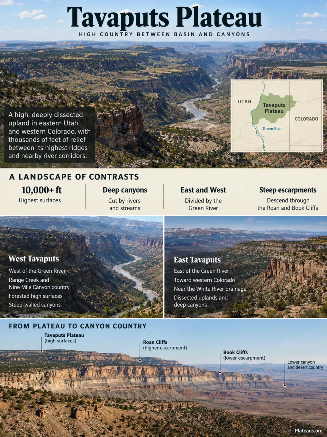
The Tavaputs Plateau is a high, deeply dissected part of the northern Colorado Plateau in eastern Utah and adjoining western Colorado. The Green River cuts through the upland and separates East Tavaputs from West Tavaputs, while the plateau’s southern margin descends through the Roan Cliffs and Book Cliffs. Some high surfaces rise above 10,000 feet, yet nearby river corridors lie thousands of feet lower, giving Tavaputs far more relief than the word “plateau” might suggest.
Green River Divide
Deeply Dissected Upland
Book–Roan Escarpment System
Where the Tavaputs Plateau Sits
The Tavaputs Plateau occupies the transition between the Uinta Basin to the north and the canyon-and-cliff country of the Colorado Plateau to the south. Its highest southern and interior surfaces stand well above the basin and surrounding lowlands, while numerous streams have cut long canyons into the upland.
The Green River provides the clearest internal division. West of the river lies the West Tavaputs Plateau, including the deeply cut country around Nine Mile Canyon and Range Creek. East Tavaputs extends from the Green River toward western Colorado. Its northern side approaches the White River drainage, while its southern edge is associated with the Roan and Book Cliffs.
Lower basin terrain lies north of the Tavaputs upland.
Broad elevated terrain rises toward high surfaces that exceed 10,000 feet in places.
A higher escarpment belt marks part of the descent from the plateau toward southern lowlands.
A prominent lower south-facing escarpment exposes older sedimentary rocks.
Lowlands south of the cliff front can stand several thousand feet below the Tavaputs surface.
This north-to-south sequence is schematic. The escarpments curve, retreat, merge and separate across the region rather than forming perfectly parallel boundaries.
Green River Divides the Plateau Into East and West Tavaputs
The Tavaputs Plateau is not normally treated as one uninterrupted upland block. The Green River cuts through the plateau system, creating the long canyon corridor that separates its eastern and western sections.
West Tavaputs
- Lies west of the Green River.
- Includes the Range Creek and Nine Mile Canyon drainage country.
- Contains high forested surfaces separated by steep-walled tributary canyons.
- Drops sharply toward the Book and Roan cliff systems along parts of its southern and western margins.
East Tavaputs
- Extends eastward from the Green River into western Colorado.
- Approaches the White River drainage along its northern side.
- Contains a dense network of dissected uplands, intermittent streams and deep canyons.
- Descends southward through the Roan and Book Cliffs region.
The distinction is more than a naming convention. Each side contains its own drainage network, canyon systems and local relief, while the Green River forms the major through-going channel between them.
Tavaputs Plateau, Roan Cliffs and Book Cliffs Are Related but Different
The names Tavaputs Plateau, Roan Cliffs and Book Cliffs are sometimes used loosely for the same general region, but they describe different parts of the landscape. Separating them makes the regional topography much easier to understand.
| Feature | Landform Character | Relationship to Tavaputs |
|---|---|---|
| Tavaputs Plateau | High, broad but strongly dissected upland | The main elevated regional surface |
| Roan Cliffs | Higher escarpment and steep slope system | Forms part of the plateau’s prominent southern margin |
| Book Cliffs | Long south-facing escarpment cut into resistant sedimentary beds | Forms a lower, outward-facing step below or south of much of the higher Tavaputs terrain |
| Uinta Basin | Broad structural and topographic basin | Lies mainly north of the plateau; Tavaputs forms its elevated southern border region |
| Desolation Canyon | Deep Green River canyon | Cuts through the plateau and helps separate East from West Tavaputs |
Viewed from the south, the landscape can resemble a giant staircase. The Book Cliffs form a conspicuous lower wall, higher terrain rises behind them toward the Roan Cliffs, and the Tavaputs upland continues beyond the escarpment crests.
Terminology Note
Historical geographic and geologic reports do not always use these names in exactly the same way. Older sources sometimes use Roan Plateau, Book Plateau or the wider Book Cliffs region for terrain that overlaps the Tavaputs Plateau. For that reason, area estimates and mapped boundaries can vary with the definition being used. A single exact plateau-area figure should not be assumed to represent every source.
The Rock Sequence Explains the Stair-Step Landscape
Tavaputs is built from thick sedimentary sequences that record very different environments. Older rocks at the southern margin include strata deposited when the western interior of North America contained a large Cretaceous seaway. Younger rocks record the retreat of that sea, river and floodplain environments, and later Eocene lakes.
Erosion acts differently on these rock units. Resistant sandstone commonly forms cliffs and benches, while shale and mudstone tend to weather into gentler slopes. Repetition of hard and soft beds helps produce the stepped profile visible along the plateau’s southern margin.
| Rock Interval | General Age and Setting | Landscape Expression |
|---|---|---|
| Mancos Shale | Late Cretaceous marine sediment | Soft shale commonly forms lower slopes and broad eroded lowlands below major cliffs |
| Mesaverde-related sandstone and shale units | Late Cretaceous shoreline, deltaic and nonmarine environments | Resistant sandstone beds form much of the prominent Book Cliffs escarpment |
| Colton and related terrestrial strata | Paleocene to Eocene river and floodplain deposits | Contribute to the higher reddish-brown Roan Cliffs and associated slopes |
| Green River Formation | Eocene lake deposits | Underlies extensive parts of the higher Tavaputs country and locally forms resistant benches and steep eroded terrain |
Geology Note
This stratigraphic arrangement is generalized. Formation names, thicknesses and which units are exposed at the surface change from west to east across the Tavaputs–Book Cliffs region. The useful pattern is the broader progression from older marine rocks at lower structural levels to younger terrestrial and lake deposits higher in the sequence.
From Inland Sea to Eocene Lake Country
The Tavaputs landscape preserves a long shift in depositional environments. During the Late Cretaceous, marine mud accumulated in the Western Interior Seaway while sand was deposited along changing shorelines and deltas. As the sea retreated, terrestrial rivers and floodplains became more important.
By the Paleogene, large lakes occupied basins in this part of the interior West. Sediments from those lakes became parts of the Green River Formation, which covers substantial areas of the Tavaputs Plateau. In the Range Creek area, Green River Formation rocks occur on the higher plateau, above older Paleocene–Eocene fluvial and lacustrine units exposed lower in the canyon system.
This history is visible vertically. Deep canyons expose older rocks beneath younger plateau strata, while the high surface preserves units that have already been stripped away from lower surrounding terrain.
Why the Tavaputs Surface Is So Heavily Dissected
From a distant viewpoint, parts of Tavaputs can form a broad, fairly even skyline. On the ground, however, the plateau is divided into ridges, benches, steep valleys and canyon walls. Some descriptions of East Tavaputs note that the terrain can be so deeply cut that it scarcely appears plateau-like at close range.
Thick Sediments Accumulated
Marine, river, floodplain and lake environments built a thick layered sedimentary sequence.
The Region Became Elevated
Regional uplift and warping left the sedimentary surface standing above neighboring lowlands.
Rivers Cut Downward
The Green River and its tributaries incised into the raised terrain instead of simply flowing across its surface.
Differential Erosion Enlarged the Relief
Sandstone resisted erosion better than shale and mudstone, leaving cliffs, benches, narrow divides and isolated high surfaces.
The result is a dissected plateau: the original regional upland identity remains recognizable, but streams have removed enough rock to fragment much of the upper surface.
Why the Green River Cuts Through the Plateau Instead of Going Around It
The Green River approaches Tavaputs from the north and continues southward through increasingly high terrain. Rather than being diverted around the upland, it descends into a deep bedrock canyon.
A commonly used geomorphic interpretation treats this reach as an example of an antecedent river. Under that interpretation, the river’s course was established while regional relief was developing, and incision kept pace closely enough for the channel to maintain its route as surrounding terrain rose.
This relationship helps explain an apparent contradiction on a topographic map: the surrounding land rises toward the south while the river continues flowing south at progressively lower elevation inside its canyon. The growing difference between river level and plateau level produces the enormous local relief of Desolation Canyon.
The deeper history of the Green River drainage is complex, so antecedence should not be read as a claim that every stage of the modern river system is known with complete certainty. It is most useful here for explaining how a through-going river can cross a major structural and topographic high instead of following the easiest route around it.
Desolation Canyon Is a Vertical Section Through Tavaputs
Desolation Canyon shows the scale of Tavaputs more clearly than the upper surface alone. The Green River and its tributaries expose thousands of feet of relief between the canyon floor and the surrounding upland.
Local Canyon Depth
Near Rock Creek, the canyon is more than one mile deep from the river corridor to the surrounding high terrain.
Elevation Range
The Desolation Canyon Wilderness Study Area spans about 5,600 feet of elevation.
River Corridor
The commonly described Desolation–Gray Canyon reach of the Green River extends for about 84 river miles.
These numbers describe different measurements and should not be merged into one plateau-elevation figure. Canyon depth is local river-to-rim relief, while the 5,600-foot value describes elevation variation across a much larger managed landscape.
The canyon also cuts across the stepped Roan and Book Cliff system. From the river, side canyons climb toward high plateau surfaces through a sequence of exposed sedimentary layers, making Desolation Canyon effectively a large natural cross-section through the Tavaputs landscape.
Range Creek Shows the Plateau’s Relief Over Only 30 Miles
Range Creek is one of the clearest small-scale examples of how much vertical relief exists within West Tavaputs. The perennial stream begins near Bruin Point at about 10,200 feet and reaches the Green River roughly 30 miles away at about 4,200 feet.
Headwaters near Bruin Point
Approximate stream length
Green River confluence
Total elevation loss
That roughly 6,000-foot descent occurs through a canyon system bordered by steep walls and numerous tributary canyons. The topography helps explain why a plateau with broad high surfaces can appear almost mountainous when viewed from inside one of its drainages.
Range Creek also illustrates how rare dependable water can be. The creek itself is perennial, but many nearby side canyons are normally dry or carry water only seasonally. During intense thunderstorms, those dry channels can rapidly become sediment-laden flash-flood routes.
Water Does Not Behave the Same Way Across the Plateau
The Tavaputs drainage network combines a major perennial river, a small number of dependable tributaries, intermittent streams, springs and many normally dry washes. Elevation, snowpack, bedrock and local groundwater conditions determine which channels continue flowing through dry periods.
On East Tavaputs, streams such as Hill Creek, Willow Creek and other tributaries drain toward the Green or White rivers, while south-flowing channels cut through the Roan and Book Cliffs. Some of these streams can become intermittent in dry years. Higher terrain may retain springs, small streams and stock ponds even when lower channels have little or no flow.
West Tavaputs shows a similarly sharp contrast. Range Creek maintains perennial flow, whereas many side canyons remain dry between storms. This uneven water distribution has helped concentrate riparian vegetation, wildlife habitat and human activity along a relatively small share of the canyon bottoms.
A Steep Ecological Gradient, Not a Single Plateau Climate
Describing Tavaputs simply as a dry plateau hides one of its most distinctive physical patterns. Elevation changes by thousands of feet between the Green River corridor and the highest uplands, creating major differences in temperature, moisture and vegetation over short horizontal distances.
Within the Desolation Canyon landscape, desert vegetation can give way to high-mountain vegetation over only about 5 to 10 miles. Lower elevations include saltbrush, blackbrush, grassland and riparian communities. Pinyon-juniper woodland, sagebrush and mountain shrub communities occupy many intermediate slopes and benches, while higher terrain supports patches of Douglas-fir, aspen and other montane forest.
Elevation Pattern
The vegetation does not form perfectly clean horizontal belts. Canyons create different slope aspects, moisture pockets and shaded sites, so plant communities often form a mosaic. A cool north-facing canyon wall can support vegetation very different from a sunny slope at nearly the same elevation.
This vertical compression of ecological environments is another consequence of deep dissection. A traveler moving only a few miles horizontally may cross an elevation difference that would require a much longer journey across a flatter plateau.
Rugged Terrain Also Shaped Human Use of Tavaputs
The same cliffs and narrow canyon systems that fragment the plateau have strongly influenced access and settlement. Range Creek provides a clear example: steep walls and limited approaches kept the drainage relatively isolated even though usable water and cultivable canyon-bottom land were present.
The canyon preserves an unusually intact archaeological record associated especially with Fremont-period occupation. Agricultural areas, habitation traces, rock imagery and storage structures occur within a landscape where movement was constrained by steep slopes and narrow corridors. Research in Range Creek has therefore examined human land use together with elevation, water availability, vegetation and the location of cultivable terrain.
Topography also explains why settlement was never spread evenly across the plateau. Canyon bottoms and stream terraces offered water and workable ground, while the surrounding cliffs, high divides and dry side canyons greatly restricted where intensive use was practical.
Why Tavaputs Still Counts as a Plateau Despite Its Canyons
A plateau does not need to remain flat at every scale. Tavaputs retains a regional elevated surface and broad high divides, but long-term river incision has cut that surface into a complex network of canyons, ridges, benches and escarpments.
The contrast is especially clear between the skyline and the canyon floor. From a distance, parts of the Tavaputs upland can appear broad and comparatively even. Inside Range Creek or Desolation Canyon, the same region is dominated by thousands of feet of local relief.
Deeply dissected plateau is therefore a more useful description than simply “flat high land.” The plateau identity comes from the large-scale elevated surface and its relationship to the Uinta Basin and surrounding lowlands; the rugged appearance comes from the Green River and its tributaries cutting deeply into that surface.