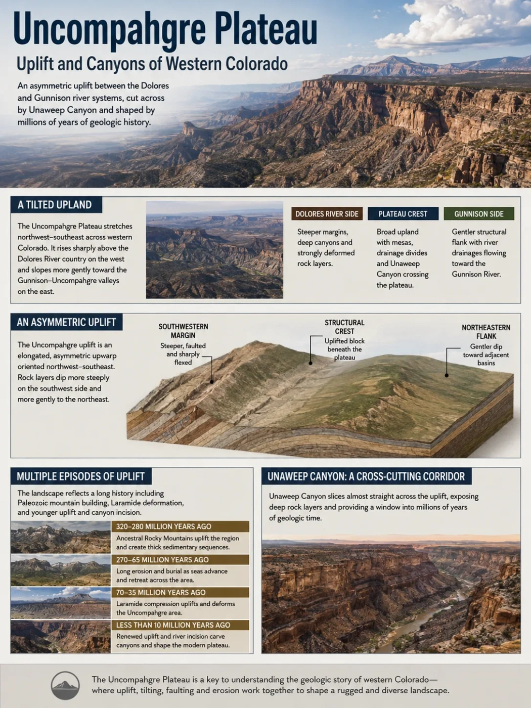
The Uncompahgre Plateau is a long, northwest–southeast upland in western Colorado where tectonic uplift, tilted rock layers and deep canyon incision overlap. Its broad crest rises between the Dolores River country to the west and the Gunnison–Uncompahgre drainage system to the east, while Unaweep Canyon cuts almost directly across the structure. That unusual combination makes the plateau useful for reading several generations of western Colorado geology in one landscape.
A Tilted Upland Between Western Colorado’s River Valleys
The Uncompahgre Plateau extends through western Colorado between the Grand Junction area and the uplands northwest of the San Juan Mountains. Its long axis trends mainly northwest to southeast. The broader landform rises from low country near the Colorado River at roughly 4,600 feet to uplands exceeding 10,000 feet in places.
The plateau is not a level tableland. Its structural and topographic form is distinctly asymmetric. The western and southwestern side rises sharply above the Dolores River country, while large parts of the eastern side descend more gradually toward the valleys associated with the Gunnison and Uncompahgre Rivers. Numerous streams cut across these slopes rather than simply following the long crest.
A steeper western and southwestern margin with deeply cut canyon country and strongly deformed rock layers in places.
A broad northwest–southeast upland interrupted by mesas, drainage divides and the cross-cutting corridor of Unaweep Canyon.
A generally gentler structural flank dissected by Escalante, Dominguez and other drainages flowing toward the Gunnison River.
Plateau and Uplift Are Related but Not Identical Terms
Uncompahgre Plateau describes the modern elevated landform. Uncompahgre uplift is the geological structure beneath and around it. Their boundaries are not necessarily identical, and the structural history reaches much farther back in time than the present topography.
The Structure Beneath the Plateau Is Asymmetric
Geological mapping describes the Uncompahgre uplift as an elongated asymmetric upwarp. Its structural axis generally follows the same northwest–southeast direction as the plateau’s topographic crest. Older regional mapping places the uplift at roughly 25–30 miles wide and more than 100 miles long as a geological structure, although the visible plateau is not defined by one precise structural boundary.
Much of the block tilts toward the northeast. Along the southwestern side, rock layers bend more sharply and are locally broken by high-angle faults. On parts of the northeastern side, the deformation is gentler, although the structure becomes pronounced again near Grand Junction where folds and faults mark the edge of the uplift.
Steeper limb, faulted and sharply flexed in several areas
Broad uplifted block underlying the modern plateau surface
Generally gentler dip toward lower terrain and adjacent basins
This geometry helps explain why the word plateau can be misleading if it is taken to mean perfectly horizontal ground. Much of the interior retains a broad upland character, yet the underlying strata, plateau margins and drainage slopes record a tilted and folded crustal block.
The Landscape Records More Than One Episode of Uplift
The modern Uncompahgre Plateau cannot be assigned to a single mountain-building event. The region experienced an older Paleozoic phase associated with the Ancestral Rocky Mountains, long erosion and burial, later Laramide deformation, and additional Cenozoic uplift and incision.
Ancestral Uncompahgre Highland
During the Late Paleozoic, the Uncompahgre region rose as one of the major uplands of the Ancestral Rocky Mountains. It was considerably larger than the modern plateau and supplied large amounts of sediment to surrounding basins.
Erosion, Burial and Sedimentation
The old highland was deeply eroded. Sediment derived from crystalline rock accumulated around its margins, while later sedimentary environments progressively covered much of the worn-down landscape.
Laramide Reactivation
Crustal compression during the Laramide orogeny reactivated the Uncompahgre structure. Faulting, folding and renewed uplift established much of the structural form underlying the present plateau.
Renewed Relief and Deep Incision
Later regional uplift and river downcutting increased relief across western Colorado. Geological evidence also points to additional differential deformation of the Uncompahgre region during the last several million years.
The First Uncompahgre Highland Was Part of the Ancestral Rockies
The Late Paleozoic Uncompahgre highland was one of several uplifts that formed the Ancestral Rocky Mountains. These were not simply earlier versions of the modern Rocky Mountains. They were a separate system of uplifts and basins that developed hundreds of millions of years before the Laramide mountain building responsible for much of today’s Rocky Mountain structure.
The ancient Uncompahgre highland was the westernmost major uplift in this Paleozoic system. Erosion stripped material from exposed crystalline basement and carried it into surrounding lowlands, including the Paradox Basin to the southwest and depositional areas to the east.
Coarse arkosic sediment in the Cutler Formation records this erosion particularly well. Near the ancient highland, the formation contains large quantities of detritus derived from exposed Precambrian rocks. The distribution of these deposits shows that a substantial highland existed even though much of its original topography was later removed or buried.
The distinction matters because the modern plateau did not simply remain standing for 300 million years. The Paleozoic highland was eroded dramatically, later sedimentary rocks covered parts of the region, and the same general crustal zone was uplifted again during younger tectonic events.
Laramide Deformation Rebuilt the Structural Relief
The Laramide orogeny affected western North America mainly between about 70 and 40 million years ago. Across much of the Colorado Plateau, deformation produced broad uplifts, basins and monoclines rather than tightly folded mountain belts. The Uncompahgre uplift is one of the clearer local departures from the comparatively undeformed character of much of the surrounding plateau province.
Older weaknesses in the crust were reused as the region was compressed. Basement faults moved, while overlying sedimentary layers bent into monoclines and fault-propagation folds. The result was an uplifted structural block whose edges could later be exposed by erosion.
This relationship is especially visible at the northern end of the plateau near Colorado National Monument. There, deformation associated with the Redlands Fault Complex connects the elevated plateau surface with the much lower Grand Valley.
Colorado National Monument Exposes the Northern Edge of the Uplift
Colorado National Monument occupies the northeastern terminus of the Uncompahgre Plateau and rises about 2,000 feet, or 600 meters, above Grand Valley. It provides one of the clearest surface expressions of how the uplift, rock layers and erosion work together.
Across much of the monument, sedimentary strata are nearly horizontal. Close to the Redlands Fault Complex, however, the same layers bend sharply into folds associated with movement in the underlying crystalline basement. The transition from Grand Valley to the plateau is therefore not simply an erosional cliff; it also reflects structural displacement and folding.
Movement within older crystalline rocks raises one side relative to nearby terrain.
Overlying Mesozoic strata absorb deformation through folding and monocline development.
The Colorado River and tributary erosion remove softer strata from Grand Valley.
Structural relief and differential erosion combine to produce the modern escarpment and canyon system.
Headward erosion then cuts into the uplifted margin. Tributaries extend canyons back into the plateau, while resistant sandstone beds preserve cliffs and projecting promontories. Continued retreat can isolate parts of these promontories as towers and spires.
Rock Resistance Controls the Shape of the Canyon Walls
Uplift provides elevation, but it does not by itself explain the cliffs, benches and towers along the plateau margins. Their shape depends strongly on differences in rock resistance.
| Rock Unit or Group | Typical Landscape Role | Where It Matters |
|---|---|---|
| Precambrian crystalline basement | Hard igneous and metamorphic rock exposed where erosion cuts through the younger cover | Unaweep Canyon, Colorado National Monument canyon bottoms and other deeply incised areas |
| Chinle Formation | Relatively softer strata that commonly weather into slopes below resistant cliffs | Northern plateau margin and canyon exposures |
| Wingate Sandstone | Massive resistant sandstone forming prominent vertical cliffs | Especially conspicuous around Colorado National Monument |
| Kayenta Formation | Resistant beds that help protect cliff tops and ledges | Plateau-edge canyon walls |
| Entrada and Morrison formations | Alternating resistant and weaker units that contribute to stepped slopes and erosional benches | Several canyon and plateau-margin exposures |
| Burro Canyon and Dakota units | More resistant upper strata that locally support higher surfaces | Especially important across parts of the southeastern plateau |
Where incision reaches the crystalline basement, the landscape also exposes a much older geological level than the Mesozoic sedimentary cover. In parts of Colorado National Monument, rocks about 1.7 billion years old lie beneath sedimentary layers that are hundreds of millions of years younger, with a major interval of missing geological time between them.
Eastern Canyons Cut Back Into the Plateau
The Uncompahgre Plateau is strongly dissected rather than preserved as one continuous smooth surface. On its eastern side, Escalante Creek, Cottonwood Creek, Big Dominguez Creek and Little Dominguez Creek descend toward the Gunnison River through increasingly deep canyon systems.
The Dominguez–Escalante area provides a clear example of this dissection. Broad upland surfaces and mesas are separated by red-rock canyons whose streams drain the eastern Uncompahgre Plateau. As incision progresses, the canyons expose successively older formations and, in some deeply eroded areas, Precambrian crystalline rocks beneath the sedimentary cover.
This pattern differs from a mountain range in which most relief follows sharp structural ridges. On the Uncompahgre Plateau, a substantial part of the ruggedness is produced by streams cutting downward and backward into an already elevated upland.
Unaweep Canyon Cuts Across the Plateau Instead of Following Its Main Slope
Unaweep Canyon is the most unusual drainage feature of the Uncompahgre Plateau. Rather than running along one side of the uplift, it cuts northeast–southwest across the plateau and crosses its structural trend almost at right angles.
The broader canyon corridor extends roughly 70 kilometers between the Whitewater area on the northeast and Gateway on the southwest. About 25 miles of the canyon cut across the uplift itself. In its deepest sections, relief approaches 1 kilometer, and the canyon exposes an inner gorge carved into Precambrian crystalline basement.
Yet no large river flows through the full canyon today. East Creek and West Creek begin near a low divide within the canyon and flow in opposite directions toward separate canyon mouths. Both are small compared with the valley they occupy.
West Creek flows southwest through the western canyon
A subtle divide lies inside a valley far larger than either modern stream requires
East Creek flows northeast toward the Gunnison drainage
This mismatch between canyon size and modern stream size is a classic case of underfit drainage. It shows that the present creeks cannot by themselves explain the entire canyon.
The Gunnison River Once Used Unaweep Canyon
River gravels preserved near and within the canyon show that an ancestral Gunnison River once flowed through part of Unaweep. The gravel composition differs from deposits associated with the Colorado River and links the former drainage to source areas within the Gunnison system.
Research on gravels near the western canyon records ancestral Gunnison occupation into the Pleistocene, with the youngest relevant deposits dated to about 1.46 ± 0.33 million years ago. This confirms that a river far larger than East Creek or West Creek once occupied the canyon.
The canyon then experienced major drainage reorganization. Thick sediment preserved within Unaweep includes a lacustrine sequence associated with a lake that existed roughly 1.4–1.3 million years ago. Geological reconstruction links that lake to major mass wasting in western Unaweep Canyon that obstructed the ancestral Gunnison.
As water and sediment accumulated behind the obstruction, the river eventually found a lower outlet toward the east. The reorganized Gunnison system then joined the Colorado River near Grand Junction, leaving Unaweep without a through-flowing trunk river.
River Occupation Is Not the Same as Canyon Origin
Evidence that the ancestral Gunnison flowed through Unaweep Canyon does not establish that it created the entire canyon from uncut bedrock. A major part of current research asks whether the river instead re-excavated an older buried valley.
Part of Unaweep May Be Hundreds of Millions of Years Older
A much older interpretation of Unaweep emerged from mapping, drilling and sediment studies showing that the modern canyon overlaps paleotopography preserved beneath younger deposits.
At the western mouth of the canyon, Permian sedimentary rocks fill a paleovalley cut into Precambrian basement. Restoring later deformation indicates that hundreds of meters of ancient relief were already present before those sediments accumulated. This supports the idea that a substantial valley existed during the Late Paleozoic and was later buried.
Under this model, the landscape passed through an unusual sequence: an ancient valley formed, sediment filled and concealed it, later uplift raised the region again, and a Cenozoic river removed part of the fill and reused the inherited corridor.
A deep valley develops in Precambrian basement during the Late Paleozoic or another pre-Mesozoic interval.
Sediment progressively fills and conceals much of the older relief.
Later tectonic deformation raises the Uncompahgre structure again.
The ancestral Gunnison removes younger fill and reoccupies part of the inherited valley.
This interpretation helps explain another unusual feature: the former Gunnison route makes a pronounced turn and cuts across the structural axis of the plateau rather than following the easiest direction suggested by the modern tilt. Reuse of an older valley would provide a pre-existing corridor through the uplift.
Geophysical Imaging Strengthens the Ancient-Valley Interpretation
Much of the critical evidence is hidden beneath the modern floor of Unaweep Canyon. Drilling and geophysical surveys show that hundreds of meters of sediment locally conceal the true bedrock floor.
High-resolution seismic reflection and electrical-resistivity work published in 2021 imaged an overdeepened Precambrian bedrock valley beneath this fill. The buried profile has a transverse U shape, and the geometry cannot readily be explained by known fault displacement or by ordinary river incision alone.
That geometry supports a pre-Quaternary glacial interpretation. Under the proposed model, an ancient glacier excavated a deep valley in crystalline basement, after which the valley was filled, preserved and eventually partially exhumed.
The Glacial Origin Is Supported, Not Fully Settled
The buried U-shaped and overdeepened bedrock profile is strong evidence for glacial excavation, but the exact age of that excavation remains less secure. A Late Paleozoic origin has been proposed and is consistent with other evidence for an ancient buried valley, while a still older pre-Quaternary age cannot be completely excluded. The interpretation should therefore be treated as an active geological model rather than a closed question.
| Observation | What It Indicates | Interpretive Limit |
|---|---|---|
| Large canyon occupied by two small opposite-flowing creeks | The modern streams inherited a valley formed under very different drainage conditions | Does not identify the original erosional process by itself |
| Gravels linked to the ancestral Gunnison | A large Gunnison drainage occupied the canyon during the Cenozoic | River occupation does not prove that the Gunnison created the entire bedrock canyon |
| Permian deposits filling older paleorelief | A substantial valley or depression existed before Mesozoic deposition | The complete geometry and original process are partly concealed |
| More than 300 m of canyon fill in some subsurface records | The visible floor lies far above parts of the buried bedrock surface | Different sediment packages record several separate episodes |
| Overdeepened U-shaped basement profile | Strongly supports excavation by ancient ice rather than simple fluvial incision | The precise age of glaciation remains debated |
The Plateau’s Canyons Expose Its Buried Basement
One reason the Uncompahgre Plateau is geologically distinctive within the northern Colorado Plateau is that deep erosion reaches the crystalline foundation beneath the sedimentary sequence in several places.
Precambrian rocks are exposed in Unaweep Canyon, in deep canyons along parts of the plateau margins, and in canyon bottoms at Colorado National Monument. Elsewhere, younger Triassic, Jurassic and Cretaceous units still cover the basement.
The distribution of these exposures is not random. Uplift raised the older rocks, while canyon incision removed the overlying sedimentary layers. Where both processes were strongest, the geological basement reached the surface. Where incision was shallower, younger formations remain intact across mesas and upland surfaces.
This produces an unusually large span of geological time over relatively short horizontal distances. A canyon can descend from Mesozoic sandstone cliffs into crystalline rocks formed more than a billion years earlier.
The Colorado, Gunnison and Dolores Rivers Frame the Plateau Differently
The major rivers around the Uncompahgre Plateau do not play equivalent geomorphic roles.
Colorado River
The Colorado River crosses Grand Valley north of the plateau and establishes a low regional base level against which the northern plateau margin rises. Tributaries cutting toward the river have helped expose the Colorado National Monument escarpment.
Gunnison River
The Gunnison receives much of the drainage from the eastern side of the plateau. Its former route through Unaweep also preserves evidence of major drainage reorganization during the development of the modern Colorado River system.
Dolores River
The Dolores flows through deeply incised country along the western side of the plateau region. The plateau rises sharply above this side, reinforcing the strong topographic contrast of the western margin.
Smaller plateau streams generally follow the modern slopes toward these larger river systems, but Unaweep shows that present drainage does not always reveal the landscape’s full history. Some valleys preserve routes established under older topographic conditions.
Uncompahgre Is a Local Uplift Within the Much Larger Colorado Plateau
The similar names can create a scale problem. The Colorado Plateau is a vast physiographic province extending across parts of Colorado, Utah, Arizona and New Mexico. The Uncompahgre Plateau is a much smaller western Colorado landform and structural uplift within its northeastern sector.
Uncompahgre Plateau
- A named upland concentrated in western Colorado
- Closely tied to a northwest–southeast structural uplift
- Strongly asymmetric in cross-section
- Cut by Unaweep and numerous tributary canyons
- Displays pronounced local faults and monoclines
Colorado Plateau
- A regional physiographic province covering roughly 337,000 square kilometers
- Extends across four U.S. states
- Characterized broadly by regional uplift and comparatively limited deformation
- Contains many different plateaus, basins, uplifts and canyon systems
- The Uncompahgre uplift is one of its more strongly deformed Laramide structures
The Uncompahgre therefore shows how a regional plateau province can contain smaller structural uplifts with their own tectonic histories. Its folds, faults and tilted margins are more localized than the broad uplift that characterizes the Colorado Plateau as a whole.
A Reused Landscape Rather Than a Single-Stage Plateau
The present surface preserves geological features created at very different times. Precambrian crystalline rocks form the foundation. A Late Paleozoic highland rose and eroded. Sediments buried parts of that older relief. Laramide deformation reactivated the region. Later uplift and river incision increased relief, while drainage reorganization abandoned major routes such as Unaweep Canyon.
That sequence explains why seemingly contradictory landforms occur together: broad upland surfaces beside kilometer-deep canyons, nearly horizontal strata beside sharp monoclines, tiny modern creeks inside an oversized valley, and ancient crystalline basement exposed beneath much younger sandstone cliffs.
Unaweep Canyon adds an even older inheritance to this structure. Its Cenozoic river history is well supported, yet subsurface evidence indicates that part of the valley may have existed long before the ancestral Gunnison entered it. Modern drainage across the Uncompahgre Plateau therefore reflects both present-day slopes and pathways inherited from landscapes that were uplifted, buried and exposed again.