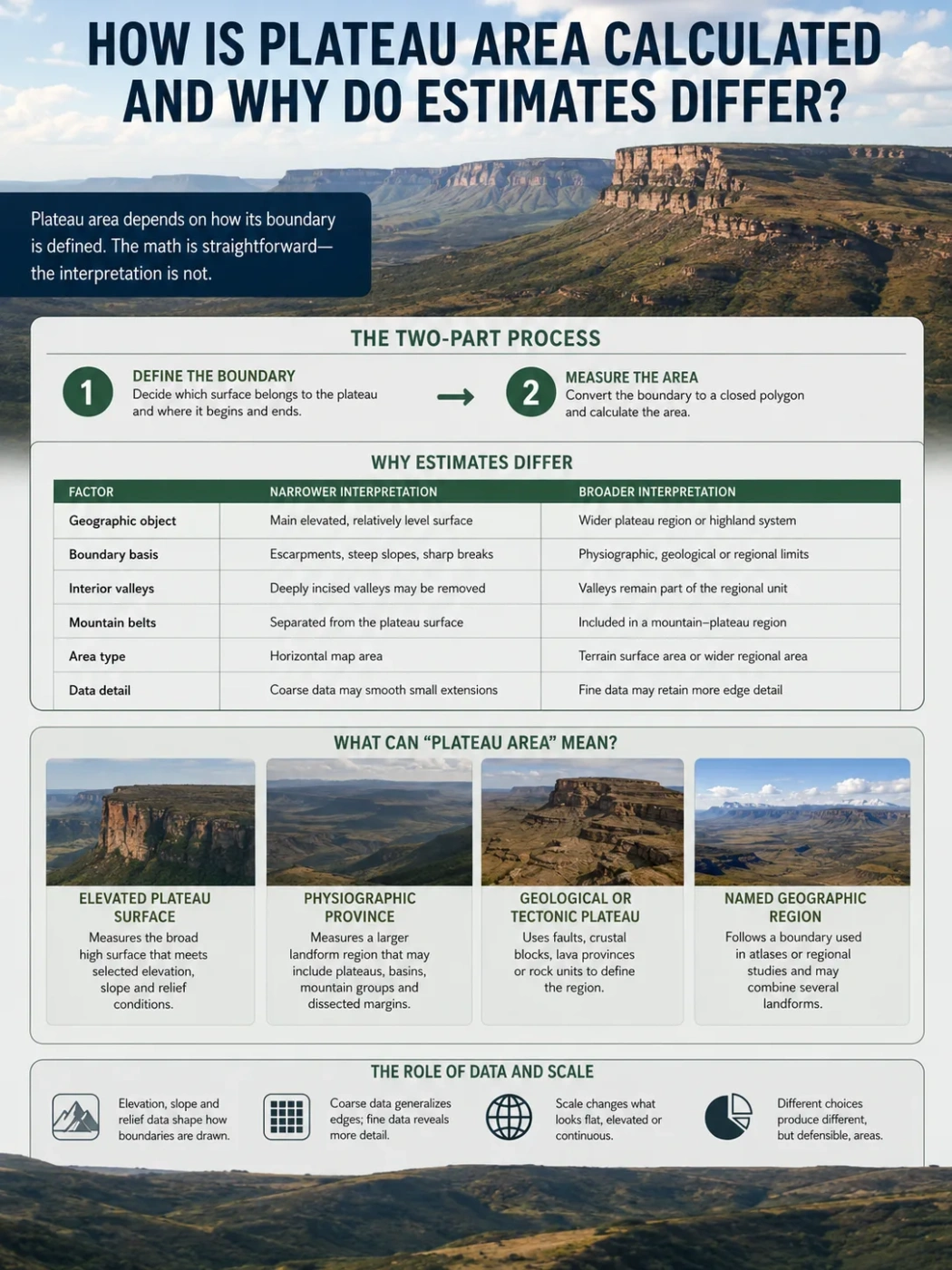
Plateau Measurement and Mapping
A plateau’s area is calculated only after its boundary has been defined. The arithmetic can be exact, while the geographic outline remains open to interpretation because elevation, slope, local relief, geology, valleys, mountain belts and transition zones do not produce one automatic edge.
A plateau area is usually reported in square kilometres or square miles, but the number does not come straight from the landform’s name. A cartographer or researcher must first decide which surface belongs to the plateau, convert that decision into a closed map boundary, and then calculate the area inside it.
This makes plateau measurement a two-part task. The first part is geographic: where does the plateau begin and end? The second part is mathematical: how large is the resulting polygon? Most disagreements arise in the first part, not the second.
Measurement Note
Two area estimates can both be defensible when they measure different versions of the same named region. One may represent the elevated plateau surface, while another includes adjoining mountains, basins and dissected margins within a wider physiographic province.
| Measurement Decision | Narrower Interpretation | Broader Interpretation |
|---|---|---|
| Geographic object | Main elevated and relatively level surface | Wider plateau region or highland system |
| Boundary basis | Escarpments, steep slopes and sharp breaks | Physiographic, geological or regional limits |
| Interior valleys | Deeply incised valleys may be removed | Valleys remain part of the regional unit |
| Mountain belts | Separated from the plateau surface | Included in a mountain–plateau region |
| Area type | Horizontal map area | Terrain surface area or wider regional area |
| Data detail | Coarse data may smooth small extensions | Fine data may retain more edge detail |
A Plateau Does Not Come with a Ready-Made Border
An island can often be traced along a shoreline. A country can be measured from a legal boundary. A plateau rarely has either kind of edge. Its margins may include a steep escarpment on one side, a mountain belt on another, and a gradual descent into lower country elsewhere.
The usual definition of a plateau—a broad area of elevated land with a relatively level or gently rolling surface—does not set one universal minimum elevation, maximum slope or minimum size. “Elevated” depends on the surrounding terrain. “Relatively level” depends on the scale of observation. A surface that looks flat on a continental map may contain deep valleys, ridges and mountain groups when viewed at finer resolution.
The name can add another layer of uncertainty. A named plateau may refer to:
- the main high, low-slope surface;
- a larger physiographic province;
- a geological or tectonic block;
- a traditional geographic region;
- or a plateau together with neighbouring mountain systems.
These versions may overlap, but they do not have to share the same outer line. A published area is meaningful only when the measured geographic object is clear.
What Can “Plateau Area” Mean?
Surface Definition
Elevated Plateau Surface
Measures the broad high surface that meets selected elevation, slope and relief conditions. Deep valleys and steep marginal slopes may be excluded.
Regional Definition
Physiographic Province
Measures a larger landform region that may include plateaus, basins, mountain groups, escarpments and dissected margins.
Earth Science Definition
Geological or Tectonic Plateau
Uses faults, crustal blocks, lava provinces or rock units to define the region, even where the topographic edge is gradual.
Map Definition
Named Geographic Region
Follows a boundary used in atlases, regional studies or long-established place-name practice. It may combine several landforms.
The distinction matters because the same plateau name can be attached to more than one of these objects. A narrow geomorphological outline and a broad regional outline should not be treated as competing measurements of one identical polygon.
How a Plateau Becomes a Measurable Polygon
Modern area calculations usually take place in a geographic information system, or GIS. Before the software can return a number, the landform must be represented as a closed vector polygon or as a set of raster cells classified as plateau terrain.
Define the Geographic Object
Choose whether the target is the main plateau surface, a physiographic province, a tectonic region or another stated unit.
Select Boundary Criteria
Use elevation, slope, local relief, escarpments, geology, drainage divides or a controlled combination of these measures.
Create the Boundary
Trace or classify the edge, close the polygon and resolve gaps, overlaps, detached pieces and internal holes.
Choose the Area Method
Calculate a projected equal-area polygon, a geodesic area on the ellipsoid, or a terrain surface area from elevation data.
Report the Assumptions
State the boundary definition, data resolution, projection, treatment of water and valleys, and the rounding level.
Vector Polygon Measurement
In a vector method, the plateau boundary is stored as a sequence of coordinates joined into a closed polygon. GIS software calculates the area enclosed by that geometry. The polygon may be drawn manually from maps and imagery, imported from a physiographic dataset, or created from a raster classification.
The geometry must be checked before measurement. Self-intersections, small gaps, duplicate segments and overlapping polygons can alter the result. A plateau split into separated surfaces may be stored as a multipart polygon rather than forced into one continuous shape.
Raster Cell Measurement
In a raster method, the terrain is divided into grid cells. Each cell carries an elevation value and may also hold derived values such as slope or local relief. Cells that meet the plateau criteria are selected, and their areas are added together:
Plateau area = the sum of the areas of all cells classified as plateau.
This looks simple, but edge cells require a rule. A cell can be counted when its centre falls inside the boundary, when most of it falls inside, or by estimating the fraction of the cell covered by the plateau. Fractional coverage can reduce abrupt jumps along irregular margins.
Field Note
The area formula does not decide whether a deeply cut valley belongs to the plateau. That choice must be made during classification or polygon design.
Five Ways Researchers Draw Plateau Boundaries
Escarpments and Breaks in Slope
A steep plateau rim can provide a clear boundary. The line may follow the top of an escarpment, the base of the scarp, or a mapped break in slope between the plateau surface and lower terrain. These options are close in concept but can enclose different areas, especially where the escarpment is wide or deeply eroded.
Many plateaus have only partial rims. A sharp edge may disappear into a gradual transition, forcing the mapper to change methods along another side of the same landform.
Elevation Thresholds
An elevation threshold selects land above a chosen height, such as all terrain above 1,000 metres. This can help identify a high region, but it rarely defines a plateau by itself. A mountain range, high plain and plateau may all cross the same contour.
Absolute elevation also behaves differently from relative elevation. A plateau at 700 metres can rise sharply above nearby lowlands, while a broad basin at 3,500 metres may sit below surrounding mountains. For this reason, some methods compare the candidate surface with its regional surroundings rather than relying only on height above sea level.
Slope and Local Relief
Slope measures how steeply the surface tilts. Local relief measures the vertical difference between high and low points within a chosen neighbourhood. Together, they help separate a broad plateau surface from rugged mountains.
The size of the neighbourhood changes the result. Local relief calculated within one kilometre captures small gullies and ridges. A ten-kilometre window describes a wider terrain pattern and may classify the same place differently. There is no neutral window size; it must match the mapping scale and purpose.
Geological and Structural Limits
Some plateaus are closely tied to a lava province, an uplifted crustal block or a fault-bounded region. Their geological boundary may remain useful even where erosion has softened the surface expression.
A volcanic plateau, for example, may be mapped by the extent of stacked lava flows. A tectonic plateau may follow major faults or crustal boundaries. These lines can extend beyond the visually level surface because geological history and present-day topography are related but not identical.
Hybrid Delineation
Many defensible plateau maps combine several forms of evidence. Elevation can identify the high terrain; slope can isolate flatter surfaces; local relief can remove rugged mountain zones; geology can help place uncertain margins; and manual review can correct obvious errors.
A hybrid method is not automatically better. Its value depends on whether every rule is stated clearly enough for another researcher to reproduce the boundary.
Map Projection Can Change the Number
Earth is curved, while most maps are flat. A map projection converts coordinates from the globe or ellipsoid to a plane. Every projection changes some combination of area, shape, distance or direction.
A polygon that looks correct on a web map may not be suitable for area measurement. Distortion can grow across very large plateaus, across broad east–west regions, and toward high latitudes. Measuring a polygon in an unsuitable projection can produce a result that differs from a properly calculated area even when the boundary itself is unchanged.
Equal-Area Projection
An equal-area projection is designed to preserve area relationships. Shape may be stretched, but the calculated size of the polygon remains appropriate for comparison. A regional equal-area projection is often chosen for a plateau that sits within one broad geographic zone.
Geodesic Area
A geodesic calculation measures the polygon on a model of Earth’s curved surface rather than treating it as a flat shape. This approach is useful for very large regions, high-latitude plateaus or polygons that cross several projection zones.
Why Coordinate Systems Must Be Reported
“Measured in GIS” does not fully describe the method. The coordinate reference system, ellipsoid and area algorithm should be recorded. Without them, another person may be unable to reproduce the number even when using the same boundary file.
Common Calculation Error
Latitude and longitude are angular coordinates, not ordinary linear units. A polygon stored in geographic coordinates should not be measured as though each degree covers the same ground distance everywhere.
Planimetric Area and Terrain Surface Area Are Different
Most geographic area figures use planimetric area: the horizontal footprint of the plateau as viewed from above. Slopes, valley walls and ridges are projected onto a flat reference surface.
Terrain surface area follows the three-dimensional shape of the land. A tilted or rugged surface covers more actual ground than its horizontal footprint. The difference is small across a very flat plateau surface and larger across dissected margins, escarpments and mountain sectors.
Planimetric Area
- Measures the horizontal map footprint.
- Common in atlases and regional area tables.
- Suitable for comparing mapped regions.
- Does not add extra area for slope steepness.
Terrain Surface Area
- Follows the three-dimensional land surface.
- Depends on elevation data and terrain detail.
- Useful for some ecological and land-surface studies.
- Usually larger across rugged terrain.
The larger number is not automatically the better one. The correct measure depends on the question. A continental landform comparison normally needs planimetric area. A study of available ground surface, habitat or erosion may need three-dimensional area.
Landform Note
The phrase “surface area” can be ambiguous. It should state whether the value is a horizontal polygon area or a slope-adjusted terrain area.
Why DEM Resolution Changes Plateau Area
A digital elevation model, or DEM, represents terrain as a grid. A 30-metre DEM and a 90-metre DEM do not see the same edge. The coarser grid averages more terrain into each cell and can smooth narrow valleys, small escarpments and short ridges.
Higher resolution can produce a more detailed boundary, but the effect on total area is not one-directional. Fine data may add small plateau remnants that coarse data missed. It may also reveal incised valleys and steep patches that are removed from the plateau class.
Edge Smoothing
A coarse model can turn a sharp rim into a broad transition. When an automated rule searches for a break in slope, the apparent boundary may shift inward or outward.
Small Valleys and Ridges
Narrow valleys may disappear in a large cell. Fine data can preserve them as non-plateau features, reducing the classified area. The same fine model can detect narrow flat benches and isolated remnants, adding area elsewhere.
DSM and DTM Differences
A digital surface model may include the upper surface of vegetation and buildings. A digital terrain model aims to represent bare ground. The distinction has little effect on a huge continental plateau at broad scale, but it can affect local slope calculations, forested rims and small plateau surfaces.
Resolution should therefore be treated as part of the landform definition, not only as a measure of visual sharpness.
Threshold Choices That Quietly Move the Boundary
Automated plateau mapping often depends on numerical cutoffs. A small change in one threshold can reclassify thousands of raster cells across a large region.
| Threshold or Rule | What It Controls | Why the Area Changes |
|---|---|---|
| Minimum elevation | How high terrain must be | A higher cutoff removes lower margins and interior basins. |
| Maximum slope | How level the surface must be | A stricter cutoff removes rolling terrain and dissected edges. |
| Local relief limit | How rugged the neighbourhood can be | A low limit separates mountains and deeply cut terrain from the plateau. |
| Relief window size | The scale at which ruggedness is measured | Small and large windows recognise different terrain patterns. |
| Minimum mapping unit | The smallest retained plateau patch | Tiny fragments may be kept, merged or removed. |
| Smoothing tolerance | How much boundary detail is retained | Generalisation removes small bends, narrow projections and minor indentations. |
| Connectivity rule | Whether separated cells form one region | Narrow links may join or divide plateau sectors. |
No threshold is universally correct for every plateau. A low volcanic tableland, a dissected sedimentary plateau and a very high intermontane plateau do not express elevation and relief in the same way.
Valleys, Mountains, Basins and Water Inside the Boundary
A plateau can contain terrain that does not look plateau-like when viewed locally. Whether these internal features remain inside the polygon is one of the main sources of variation.
Deep River Valleys
A river may cut hundreds or even thousands of metres below the surrounding plateau surface. One method may treat the valley as erosion within the plateau and keep it inside the regional boundary. Another may remove the valley floor and steep walls from a surface-based classification.
Mountains Rising Above the Plateau
Mountain groups can rise from a plateau without ending the wider plateau region. A physiographic map may include them. A low-slope surface map may exclude them. Both choices can be useful, but they answer different questions.
Interior Basins
Closed basins may sit within the same tectonic region while lying below a selected elevation threshold. Excluding them can produce holes in the polygon. Including them creates a more continuous regional unit.
Lakes and Reservoirs
A reported figure may describe total area inside the outer boundary or land area after water bodies are removed. The difference is often modest, but it can matter in lake-rich plateau regions. Tables should not compare total area for one plateau with land-only area for another.
Why Named Regions Produce Very Different Estimates
Terms such as plateau, highlands, uplands, tableland, physiographic province and mountain–plateau system are not interchangeable. A source can use a broad regional name while another uses a stricter landform boundary.
This is especially important where a plateau merges with high mountain belts. Elevation alone may place both inside one high region, while slope and relief separate the flatter plateau surface from rugged mountain terrain.
Common Mix-Up
A “highland region” may contain plateaus, mountains, basins and valleys. Its area should not automatically be used as the area of one plateau within it.
The Tibetan Plateau Shows Why Name and Scale Matter
The Tibetan Plateau is often described with a rounded area near 2.5 million square kilometres, but published outlines vary because researchers do not always measure the same geographic unit. Some boundaries focus on the plateau proper. Others extend into the Himalaya, the Hengduan Mountains, the mountains of Central Asia or a broader High Mountain Asia region.
One multidisciplinary delineation separated a narrower Tibetan Plateau polygon of about 1.82 million square kilometres from a much wider Pan-Tibetan highland region of about 3.95 million square kilometres. The gap between those values is too large to be explained by rounding or GIS software. It comes from the geographic scope.
The case illustrates three recurring problems:
- Plateau core and mountain belts: adjacent mountain systems may be included or mapped separately.
- Elevation overlap: both plateau and mountain terrain sit at high elevations, so a height threshold cannot separate them cleanly.
- Regional naming: one name may be used loosely for a wider highland region in general writing.
A reliable comparison must therefore examine the boundary map and description before comparing the area number.
The Colorado Plateau Shows Why One Edge Method Is Not Enough
The Colorado Plateau has several kinds of margin. Parts of its western side are associated with faults, volcanic terrain and strong topographic transitions. The southern margin is marked in places by the Mogollon Rim. Elsewhere, the plateau grades into neighbouring provinces through less abrupt terrain.
A mapper may follow a clear escarpment for one section, a structural boundary for another and a conventional physiographic line through a transition zone. The resulting polygon is still useful, but not every segment carries the same level of boundary certainty.
| Boundary Segment Type | Typical Evidence | Expected Confidence |
|---|---|---|
| Sharp topographic edge | Escarpment, rim or abrupt break in slope | Usually easier to trace |
| Structural edge | Fault zone or mapped geological contact | Strong when geological mapping is clear |
| Drainage or divide boundary | Watershed line used to separate regions | Clear as a line, but not always a landform edge |
| Gradual transition | Slow change in elevation, slope or relief | More dependent on selected thresholds |
| Traditional regional line | Long-used physiographic or cartographic boundary | Useful for continuity, but partly conventional |
Why More Decimal Places Do Not Mean More Accuracy
GIS software can return an area such as 1,823,417.36 square kilometres. That precision belongs to the geometry and calculation, not necessarily to the landform definition.
If part of the boundary could reasonably move by tens of kilometres, reporting hundredths of a square kilometre creates false precision. A rounded value such as “about 1.82 million square kilometres” may represent the real level of geographic certainty more honestly.
Small differences can also come from:
- conversion between square miles and square kilometres;
- rounding at different stages of calculation;
- older values copied into newer references;
- updated shoreline or water-body data;
- revised boundary files;
- different ellipsoids or projection parameters.
These causes usually explain modest gaps. Very large gaps point more often to different boundaries or different geographic objects.
How to Compare Two Conflicting Plateau Areas
- Check the exact place name. Determine whether both sources refer to the plateau proper or whether one uses a broader highland or physiographic region.
- Look for a boundary map. Two values should not be treated as directly comparable when their polygons differ.
- Identify included mountain belts and basins. These features can add or remove large areas.
- Confirm the area type. Compare planimetric area with planimetric area, not with three-dimensional terrain area.
- Review the projection or geodesic method. This matters most for large and high-latitude regions.
- Check DEM resolution and thresholds. Automated classifications can shift when cell size, slope limits or relief windows change.
- Check water treatment. One source may include lakes while another reports land area only.
- Compare rounding levels. A small gap may be a unit-conversion or rounding effect rather than a real mapping disagreement.
What Better Elevation Data Can and Cannot Resolve
Modern global elevation products can map plateau margins in far more detail than older small-scale paper maps. They can show narrow valleys, stepped rims, lava surfaces, isolated remnants and local relief patterns that were previously generalised.
Better data can improve the position of a mapped edge. It cannot decide:
- which slope should count as “relatively level”;
- whether an adjacent mountain belt belongs to the plateau region;
- whether an interior basin should remain inside the outline;
- whether a geological or topographic boundary should take priority;
- or which historical use of a place name should control the map.
More detailed terrain data improves observation. The landform definition still requires a stated geographic choice.
What a Reproducible Plateau Area Should Report
| Reported Item | What It Tells the Reader |
|---|---|
| Measured geographic object | Whether the value represents a plateau surface, physiographic province, geological region or wider highland system. |
| Boundary definition | Which terrain is included and where transition zones are placed. |
| Boundary criteria | How elevation, slope, local relief, geology, escarpments or drainage divides were used. |
| Included subregions | Whether mountain belts, basins, dissected margins and detached plateau sectors are counted. |
| Elevation dataset | The DEM, DTM or DSM used to model the terrain. |
| Spatial resolution | The cell size or mapping scale at which terrain detail was recognised. |
| Coordinate reference system | The projection or geodesic basis used for area calculation. |
| Area representation | Whether the value is a two-dimensional footprint or a three-dimensional terrain surface. |
| Calculation method | Whether the two-dimensional polygon was measured in an equal-area projection or with a geodesic algorithm. |
| Water treatment | Whether lakes and reservoirs are included in total area or removed for land-only area. |
| Boundary version and date | Which edition of the polygon was measured and whether later revisions may differ. |
| Rounding and uncertainty | How closely the reported digits match the certainty of the boundary. |