INTERACTIVE CONTEXT MAP
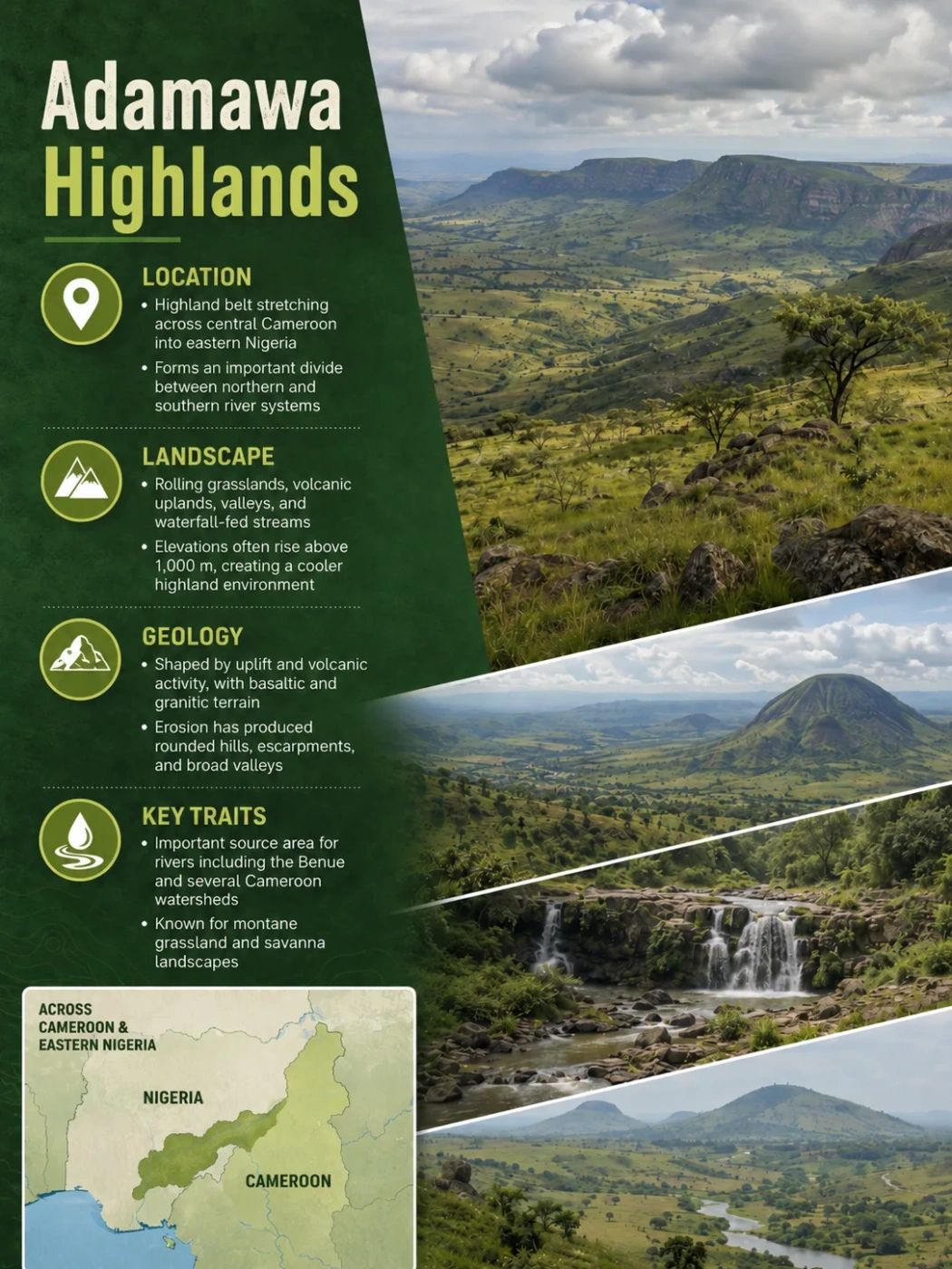
Where is Adamawa Plateau?
The selected plateau and nearby mapped locations are shown. Open the full world atlas to explore every region.
The Adamawa Plateau is a broad elevated region centered on north-central Cameroon, where a roughly kilometer-high surface separates major river basins and forms a climatic transition between wetter equatorial Central Africa and the drier country to the north. Its landscape is not a single flat tableland: old crystalline rocks, major faults, volcanic centers, crater lakes, river-cut valleys and higher local massifs combine to create a varied upland.
Where the Adamawa Plateau Lies
The clearest physical expression of the Adamawa Plateau lies in central and north-central Cameroon, especially around Ngaoundéré and the surrounding high country. From there, the wider Adamawa highland belt continues west toward southeastern Nigeria and east toward the Central African Republic.
This creates an important naming problem. In broad regional geography, Adamawa Plateau or Adamawa Highlands may describe a transboundary belt of elevated terrain. Geological and geophysical studies, however, often use Adamawa Plateau more narrowly for the uplifted and volcanic plateau of central Cameroon. The physical landform therefore does not have one universally fixed political boundary.
Geography Note
The Adamawa Plateau should not be mapped simply by tracing the administrative boundary of Cameroon’s Adamawa Region. The province and the physical highland overlap, but an administrative region and a landform are defined in different ways.
High terrain continues toward the Nigeria–Cameroon border and related uplands such as the Gotel and Mambilla areas.
The best-defined Adamawa Plateau lies around Ngaoundéré and the central Cameroonian uplift.
Elevated terrain continues toward eastern Cameroon and the Central African Republic.
Its northern margin is especially important. Here the high ground gives way toward the lower Benue Trough and northern plains. The contrast is much more pronounced than the gradual southward transition into lower plateau country. Modern tectonic-geomorphology studies likewise distinguish the high-to-mid-relief Adamawa terrain from the lower Benue basin immediately to the north.
The Main Plateau Surface Is Around One Kilometer High
There is no single elevation that represents the whole Adamawa Plateau. In the central Cameroonian core, much of the upland lies at roughly 1,000 to 1,200 metres above sea level. Geophysical profiles have measured about 800 metres in northern sectors and around 1,200 metres farther south, while broader definitions of the Adamawa Highlands include terrain extending through a wider elevation range.
Common elevation across much of the central plateau
Annual rainfall reported around the central plateau
Main wet season
These values describe the plateau surface, not every summit rising from it. Volcanic hills and mountain masses locally climb well above the surrounding upland. Using the elevation of one high summit as the elevation of the Adamawa Plateau would therefore exaggerate the height of the regional land surface.
The plateau is also far from perfectly level. Broad rolling surfaces are interrupted by hills, volcanic cones, valleys and steep breaks in slope. Rivers have cut into the uplifted land, while volcanic construction has added local high points. In map view the Adamawa may appear as a broad elevated block; on the ground it can look like a mixture of rolling savanna, dissected upland and rugged volcanic terrain.
Elevation and Relief
A plateau elevation and a mountain summit elevation answer different questions. Adamawa’s identity comes from the broad regional level of the high ground relative to the surrounding basins, not from its highest isolated peak.
Adamawa Is an Uplifted Plateau With a Volcanic Overprint
The physical structure beneath Adamawa explains why the landscape cannot be described simply as a volcanic plateau. The region rests on an older foundation of Precambrian crystalline and metamorphic rocks, including granitic and gneissic material, migmatites, schists and related basement rocks. Volcanic rocks cover parts of this much older foundation rather than replacing it.
The central Cameroonian plateau is commonly interpreted as an uplifted fault-controlled block, or horst. Its northern and southern margins are associated with major faults belonging to the Central African Shear Zone, a large inherited system of crustal weaknesses extending across Central Africa.
Geophysical studies beneath Adamawa show that the unusual surface relief is linked to structure deep in the crust and upper mantle. The lithosphere beneath the area is thinner than beneath some surrounding regions, and old shear zones provided pathways along which magma could rise. This helps explain why tectonic uplift and volcanism occur in the same geographic belt.
The Connection With the Cameroon Volcanic Line
Adamawa intersects the northeastern continental sector of the Cameroon Volcanic Line, the long volcanic province that extends from islands in the Gulf of Guinea across western and central Cameroon toward the Lake Chad region.
Volcanism on the plateau did not occur in one short event. Older basaltic flows were followed by later volcanic activity that produced cones, craters, domes and other volcanic forms. Around Ngaoundéré, geological work has identified older Miocene volcanic rocks alongside much younger Quaternary features.
This sequence matters because the present landscape combines several stages of development. Adamawa first inherited an ancient crystalline foundation and major structural weaknesses. Regional uplift raised the land. Magma then reached parts of the surface through the faulted crust, while weathering and rivers continued to reshape the elevated terrain.
Precambrian crystalline and metamorphic rocks form much of the geological foundation.
Inherited shear zones and crustal deformation helped raise the Adamawa block above neighboring basins.
Basaltic flows, volcanic cones, plugs and craters were added during several periods of volcanic activity.
Streams cut valleys into the raised surface, producing the broken relief visible today.
Why Crater Lakes Occur on the Plateau
One visible result of this volcanic history is the concentration of small lakes in volcanic depressions around the central plateau. Lakes near Ngaoundéré occupy craters or other closed volcanic landforms and sit within catchments underlain partly by volcanic rock.
These lakes are more than isolated landscape features. Their sediments preserve records of environmental change, allowing researchers to reconstruct shifts in rainfall, vegetation and local conditions over thousands of years. They also show how closely Adamawa’s present drainage and ecology are tied to its volcanic topography.
Climate Changes Across Adamawa Because It Is Both High and Transitional
The Adamawa Plateau lies between two broad climatic settings. To the south, Cameroon becomes wetter and more equatorial. To the north, rainfall decreases toward the Sudanian and Sahelian zones. Adamawa occupies the elevated transition between them.
Its climate is often described as an altitudinal tropical climate. Elevation keeps the central plateau cooler than nearby lower northern terrain, while seasonal movement of tropical rain belts produces a strong wet–dry rhythm.
A Long Wet Season and a Distinct Dry Season
In the Ngaoundéré area, the main rainy season generally runs from April through October. The dry season extends from approximately November through March.
A meteorological record from Ngaoundéré airport covering 2000–2017 measured average annual precipitation of about 1,464 millimetres. Annual totals varied considerably from year to year, which is one reason a single rainfall number should not be treated as a fixed value for the entire plateau.
The same record shows relatively moderate monthly mean temperatures for a tropical location at this latitude. Average monthly temperature ranged from about 19.5°C in December and January to 24.5°C in March. Higher elevation is an important reason the central plateau remains cooler than the lower Benue country to the north.
The ITCZ, Monsoon Air and Harmattan Shape the Seasons
The seasonal cycle is closely tied to movement of the Intertropical Convergence Zone. During the wetter part of the year, humid southwesterly air reaches the plateau and supports frequent rainfall. During the dry season, the atmospheric pattern shifts and drier northeasterly Harmattan air becomes more influential.
This produces a sharper seasonal contrast than in the wetter parts of southern Cameroon. Rainfall becomes concentrated into one main wet season instead of the more strongly bimodal rainfall pattern found farther south.
Rainfall Pattern
Instrumental rainfall data covering 1987–2022 in the central Adamawa area show a tendency toward more precipitation during the wet season and less during the dry season over the record. This is best read as a change in seasonal distribution within the observed dataset, not as evidence that every part of the wider Adamawa Highlands is becoming uniformly wetter.
The Plateau Divides Some of Central Africa’s Major River Systems
Adamawa’s position as elevated interior terrain makes drainage one of its defining geographic features. Water falling on different sides of the highland can eventually reach entirely different basins.
The plateau should not be imagined as one sharp ridge from which every river begins at the same point. It is a broad watershed region made of rolling divides, volcanic uplands and dissected surfaces. Small differences in slope determine whether streams ultimately join the Niger system, the Sanaga and Atlantic drainage, or the Lake Chad basin.
Benue Drainage to the Northwest
The Benue River, one of the Niger River’s largest tributaries, has its headwaters in the Adamawa highlands of Cameroon. From the high country it flows toward the lower Benue basin and then west through Nigeria before joining the Niger.
The contrast between the plateau and the Benue Trough is therefore both topographic and hydrologic. The elevated Adamawa surface supplies water to a major river system occupying much lower terrain immediately to the north and west.
Sanaga Drainage to the South
Southward-flowing drainage connects Adamawa with the Sanaga system, Cameroon’s largest river basin. The Djérem and other headwater rivers drain the plateau and surrounding high country before their waters continue toward the Atlantic.
The southern flank is less like a single cliff and more like a broad transition into lower central Cameroonian plateau surfaces. Rivers crossing this transition progressively cut into the high ground while gathering tributaries from a large catchment.
Northeastern Drainage Toward Lake Chad
Other headwaters from the eastern and northeastern parts of the Adamawa region feed rivers connected with the Logone–Chari system and ultimately Lake Chad. This gives the plateau a rare geographic role: nearby drainage divides separate rivers whose final destinations lie in very different directions.
Adamawa headwaters → Benue → Niger → Gulf of Guinea
Adamawa drainage → Djérem and related headwaters → Sanaga → Atlantic Ocean
Regional headwaters → Logone–Chari system → Lake Chad
Because these river systems cut into an already elevated surface, drainage has also helped create Adamawa’s present relief. Valleys, steep river slopes and locally abrupt drops break the plateau into smaller upland blocks. Where channels cross resistant rock or descend rapidly, waterfalls and rapids can develop.
Wooded Savanna Covers the Uplands, While Valleys Hold Wetter Vegetation
Adamawa’s vegetation reflects the same north–south transition seen in its climate. Much of the central plateau supports wooded savanna and open grass-dominated landscapes, but vegetation is not uniform across the surface.
Permanent or seasonally reliable moisture changes conditions along valleys. Semi-deciduous and gallery forest vegetation can follow humid drainage corridors through otherwise more open savanna. Ravines and sheltered sites may also support trees associated with cooler or wetter local conditions.
This creates a recognizable landscape pattern: relatively open upland surfaces are interrupted by darker, more densely vegetated river valleys. The pattern is especially useful for understanding why Adamawa can appear grass-dominated in one location and much more wooded only a short distance away.
Wooded savanna, grassland and open rolling terrain are widespread.
Reliable moisture supports denser gallery and semi-deciduous forest vegetation.
Crater lakes and enclosed basins create additional local wet environments.
Vegetation therefore reinforces the idea that Adamawa is a transitional landscape rather than a uniform block. Elevation, seasonal rainfall, volcanic depressions, drainage and local soil moisture all influence what develops on the surface.
Adamawa Plateau, Adamawa Highlands, Gotel Mountains and Mambilla Plateau
Several geographic names overlap in the Nigeria–Cameroon border region, which can make maps and reference sources appear contradictory. The safest interpretation is to separate the broad Adamawa highland system from the more specifically named plateau and mountain units within or beside it.
| Name | Main Geographic Use | Relationship |
|---|---|---|
| Adamawa Plateau | Most clearly associated with the elevated central Cameroonian plateau around Ngaoundéré | Core uplifted and partly volcanic plateau; broader definitions may extend beyond Cameroon |
| Adamawa Highlands | Broader regional highland belt extending across national boundaries | Useful when referring to the wider elevated system rather than one precisely bounded plateau surface |
| Gotel Mountains | Mountainous terrain near the Nigeria–Cameroon border | Related to the western Adamawa highland belt but not a synonym for the entire Adamawa Plateau |
| Mambilla Plateau | High plateau centered in Taraba State, Nigeria, beside the Cameroonian border | A distinct named plateau connected geographically with the wider Adamawa highlands |
Mambilla is generally higher than the central Cameroonian Adamawa surface, with large areas around 1,500–1,800 metres. Treating its elevation as representative of the Adamawa Plateau would therefore mix two different geographic units. The same applies to the more rugged Gotel Mountains.
The distinction also explains why descriptions of Adamawa vary so much between sources. A geological paper examining the Cameroonian uplift, a regional geography describing the Adamawa Highlands and a Nigerian study of Mambilla may all be discussing connected high terrain while using different spatial boundaries. The names become clearer once the scale of the landform is separated from the names of its local plateau and mountain sectors.