INTERACTIVE CONTEXT MAP
Where is Jos Plateau?
The selected plateau and nearby mapped locations are shown. Open the full world atlas to explore every region.
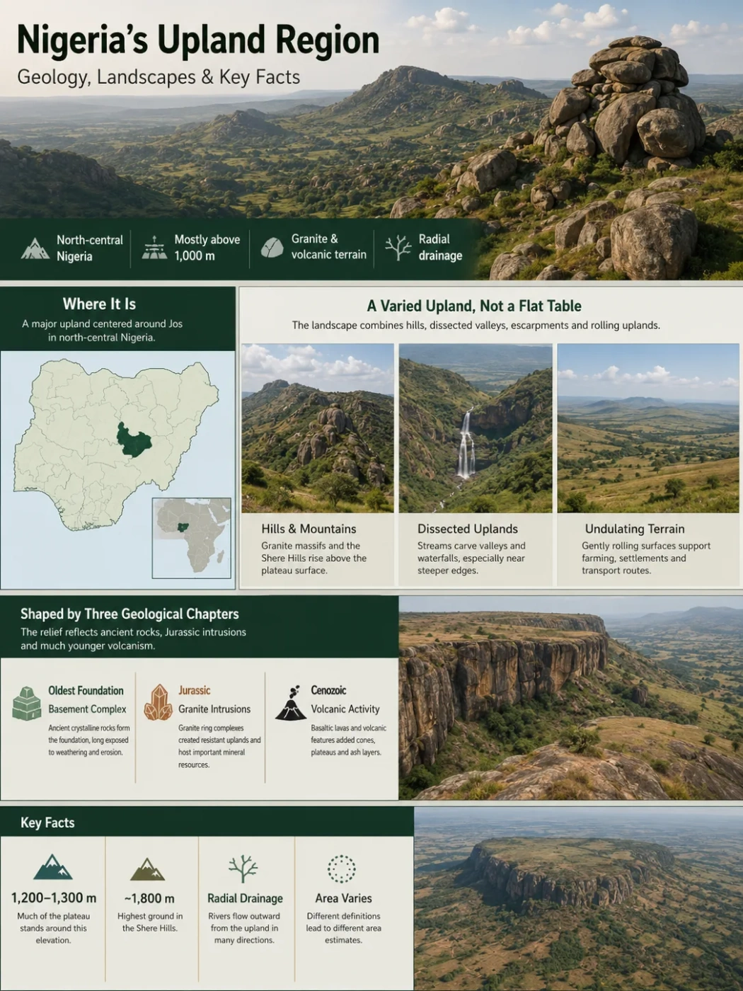
The Jos Plateau is a broad upland centered around Jos in north-central Nigeria. Much of its surface stands around 1,200–1,300 metres above sea level, while the highest ground in the Shere Hills reaches roughly 1,800 metres. Granite massifs, volcanic features, rolling uplands and dissected escarpments make it far more varied than the word “plateau” may suggest.
Mostly above 1,000 m
Granite and volcanic terrain
Radial drainage
Where the Jos Plateau Sits — and What the Name Refers To
The Jos Plateau rises above the surrounding plains of north-central Nigeria. Jos, the capital of Plateau State, occupies part of the upland and gives the landform its modern name.
The Jos Plateau, Plateau State and the city of Jos are not the same thing. The plateau is a physical landform. Plateau State is an administrative area whose boundaries extend beyond the plateau itself, while Jos is a city built on the upland. Keeping those three meanings separate prevents many location and size errors.
Why Published Area Figures Differ
There is no single universally mapped edge for the Jos Plateau. Some figures describe the core topographic upland, while broader ecological or regional definitions include more of the surrounding highland landscape. For that reason, an exact area can change with the boundary being used.
The Plateau Is an Upland Mass, Not a Flat Table
A satellite view or topographic map shows a raised region rather than a level slab. Broad rolling surfaces are interrupted by granite hills, rocky ridges, volcanic remnants, shallow basins and valleys. Around parts of the outer edge, the land drops toward lower plains through steep slopes and escarpments.
Geomorphologists divide the landscape into three broad terrain groups that help explain how the plateau looks on the ground.
Higher Relief
Hills and Mountains
Granite massifs, rocky hills and the Shere Hills rise above the general plateau surface. These high points give the region a broken skyline rather than a uniform elevation.
Cut Terrain
Dissected Uplands
Streams have cut valleys into parts of the plateau, especially toward steeper margins. Waterfalls occur where channels cross sharp changes in relief.
Broader Surfaces
Undulating Terrain
Large areas consist of gently rolling ground between hills and valleys. These surfaces support much of the plateau’s settlement, farming and transport network.
This mixture matters because the name “plateau” describes the region’s overall elevated position. It does not mean every part of the surface is flat or sits at the same height.
Three Geological Chapters Explain the Jos Landscape
The relief of the Jos Plateau reflects several very different episodes of Earth history. Ancient basement rocks form the foundation, Jurassic igneous intrusions created resistant granite complexes, and much younger volcanic activity added basalt, cones and other volcanic forms.
Basement Complex
Ancient crystalline rocks underlie much of the region. Long periods of weathering and erosion exposed and reshaped this basement before later igneous activity altered the landscape again.
Younger Granite Ring Complexes
Granite magmas intruded the older crust in a series of ring-shaped complexes. These resistant rocks now form many of the plateau’s massive outcrops, rocky hills and sharply defined uplands. They are also closely tied to the region’s tin and columbite mineralization.
Volcanic Activity
Later eruptions produced basaltic lava and volcanic centers across parts of the plateau. More than 20 dormant or extinct volcanic centers have been described, grouped into several volcanic lines. Their remains add cones, lava-covered surfaces and local changes in soil and drainage.
The result is a composite landscape. Granite does not explain every hill, and volcanism did not create the whole plateau. The present upland reflects resistant rock, repeated igneous activity, long erosion and river incision acting together over very different timescales.
Why the Shere Hills Stand Above the Main Surface
The Shere Hills, east of Jos, contain the highest terrain on the plateau. Modern geomorphological work places the plateau’s highest point at about 1,829 metres above sea level, although older maps and secondary sources sometimes give lower summit figures.
That difference is a useful reminder that “the elevation of the Jos Plateau” is not one number. The broad upland is commonly described around 1,200–1,300 metres, while individual hills rise hundreds of metres above nearby plateau surfaces.
Elevation Note
Average plateau elevation, city elevation and maximum summit elevation measure different things. A value quoted for Jos city should not be treated as the elevation of the entire Jos Plateau.
Rivers Flow Outward From the Upland
The Jos Plateau acts as a major watershed because it stands above large areas around it. Streams begin on the upland and descend in several directions, producing a broadly radial drainage pattern. Local drainage can be dendritic or structurally controlled, but the regional pattern is outward from the high ground.
Headwaters feed the Kaduna River system, which ultimately joins the Niger.
Drainage contributes to rivers linked with the Gongola and Benue systems.
Other headwaters feed the Hadejia–Jama’are–Yobe drainage network toward the Lake Chad Basin.
Short, steeper streams occur near dissected edges of the plateau. Where resistant rock creates abrupt steps in a river profile, waterfalls and rapids can form. Farther from the upland, these streams enter lower-gradient river systems and larger basins.
Elevation Makes Jos Cooler Than the Surrounding Lowlands
The plateau lies in the tropics, but height changes its local climate. Air temperatures are generally lower than on nearby lower plains, and Jos is widely known for this cooler upland setting. Rainfall is strongly seasonal, with most precipitation falling during the wet part of the year and July and August usually among the wetter months.
Relief also affects where rain falls. Moist air approaching the upland can be forced upward along slopes, helping produce local rainfall differences across the plateau. The combination of altitude, rainfall and varied terrain supports an upland vegetation pattern distinct from many surrounding lowlands.
The natural landscape belongs to the Jos Plateau forest-grassland mosaic, an upland ecological zone of grassland, savanna, woodland and small forest patches. Much of the plateau has long been used for settlement, cultivation and grazing, so present vegetation is a mix of natural and human-shaped cover.
Tin Geology Also Changed the Surface
The Jos Plateau is closely associated with cassiterite, the main ore of tin, and with columbite-bearing mineralization. These minerals are linked especially with the Younger Granite province. Weathering released dense mineral grains from their source rocks, and running water concentrated part of that material in valleys and alluvial deposits.
This geological process helps explain why mining became strongly connected with streams and valley floors rather than only with solid bedrock. Historic and later mining excavated alluvial sediments, created pits and ponds, and reworked local drainage in parts of the plateau. As a result, some present-day depressions and water-filled excavations are human-made features rather than volcanic craters or natural lakes.
Landform Mix-Up
A round or water-filled depression on the Jos Plateau is not automatically a volcanic crater. The region contains genuine volcanic landforms, but it also contains many excavations and altered surfaces associated with mining.
What Makes the Jos Plateau Distinct Within Nigeria
The Jos Plateau combines several geographic traits in one upland: a high surface surrounded by lower plains, resistant granite ring complexes, younger volcanic terrain, deeply cut margins and rivers that disperse toward different drainage basins.
Its identity comes from that combination rather than from elevation alone. The plateau is both a topographic high and a geological mosaic. It also functions as a watershed and creates a cooler ecological setting within tropical north-central Nigeria. Those relationships explain why the Jos Plateau stands out on Nigeria’s physical map even though its surface is neither uniformly flat nor geologically uniform.