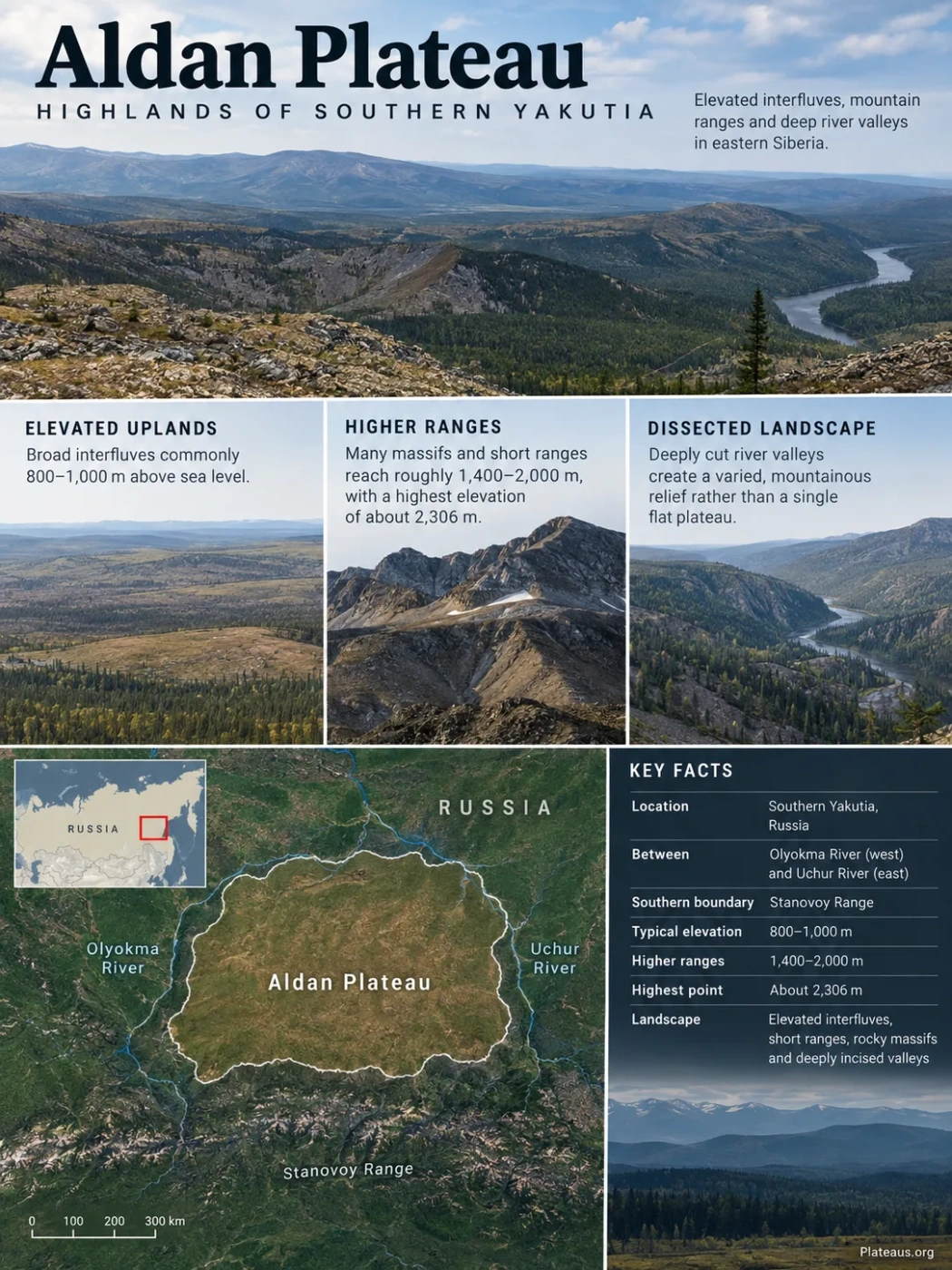
The Aldan Plateau, widely known as the Aldan Highlands, is a deeply dissected upland in southern Yakutia, Russia. Its broad interfluves commonly stand around 800–1,000 metres above sea level, while short mountain ranges and isolated rocky massifs rise far higher. Beneath this uneven surface lies part of the ancient Aldan Shield, where rocks preserve more than three billion years of continental-crust history.
Why the Aldan Plateau Is Not a Simple Flat Plateau
The name Aldan Plateau can give the wrong impression if “plateau” is taken to mean one broad, level tableland. The Russian name, Aldanskoye Nagorye, is more naturally translated as Aldan Highlands or Aldan Upland, and that description better reflects the modern terrain.
Much of the region consists of elevated, comparatively level or gently rolling surfaces between river valleys. These surfaces are interrupted by short ranges, isolated mountain groups and deeply cut drainage systems. The result is a landscape that combines plateau-like interfluves with distinctly mountainous relief.
Landform Classification
Aldan Plateau and Aldan Highlands refer to the same broad geographic region in English usage. “Highlands” better conveys its mixture of elevated erosion surfaces, ridges, rocky massifs and incised valleys. It should not be pictured as a single flat-topped plateau.
Between the Olyokma and Uchur Rivers in Southern Yakutia
The Aldan Highlands occupy part of southern Sakha Republic, or Yakutia, in eastern Siberia. Their broad geographic position is defined most clearly by major river systems: the Olyokma River lies toward the west and the Uchur River toward the east.
Olyokma River and the neighboring Olyokma-Chara uplands
Elevated interfluves, short ranges and deeply dissected river valleys
Uchur basin, with higher terrain continuing toward the Dzhugdzhur region
The Stanovoy Range forms the major mountain system to the south. To the north, the terrain grades toward the Aldan basin and lower plateau country associated with the broader Lena drainage region. These neighboring landforms help explain why the Aldan area is treated as a highland system rather than as an isolated mountain range.
Several important interior rivers, especially the Timpton and Gonam systems, cross or drain high parts of the upland. Some of the strongest relief occurs in the interfluves around these drainage basins.
A Two-Level Landscape of Broad Interfluves and Higher Ridges
The characteristic shape of the Aldan Highlands becomes clearer when its relief is separated into two broad levels. Large parts of the upland are formed by subdued interfluves, while mountain ridges and rocky summit groups project above them.
| Terrain Element | Typical Elevation | Landscape Character |
|---|---|---|
| Broad interfluves | About 800–1,000 m | Elevated, relatively even or gently rolling surfaces between valleys |
| Higher massifs and short ranges | Many reach roughly 1,400–2,000 m | Rockier relief rising above the older upland surface |
| Highest terrain | About 2,306 m | Local summit relief rather than the general elevation of the plateau |
This distinction matters because the frequently quoted figure of 2,306 metres is a maximum elevation, not a representative plateau height. Much of the characteristic upland surface lies several hundred metres lower.
Named relief units within the highlands include the Western Yangi, Sunnagyn and Ket-Kap ranges. These are not separate mountain systems surrounding a flat central plain. They rise within the larger highland landscape and help give it its irregular vertical structure.
Elevation Note
Published geographic sources agree on a maximum elevation of about 2,306 m, but summit naming and individual peak elevations are not fully consistent across maps and secondary references. It is safer to treat 2,306 m as the published maximum for the highlands rather than attach it uncritically to a specific named summit.
River Incision Has Broken the Upland Into Separate Blocks
Elevation alone does not explain the appearance of the Aldan Highlands. River erosion is equally important. Tributaries of the Aldan and Amga systems have cut deeply into the elevated surface, separating interfluves and exposing steep valley sides beneath the smoother upland terrain.
This is why a landscape developed from broad erosion surfaces can appear strongly mountainous when viewed from a river valley. The relatively level remnants are preserved above, while drainage has removed large volumes of rock between them.
Broad interfluves preserve comparatively even high ground.
Rivers cut downward through the surface and separate the upland into distinct blocks.
Plateau remnants, ridges, slopes and river corridors occur together.
The Aldan River Connects the Highlands to the Lena Basin
The regional drainage ultimately belongs largely to the Lena River system. The Aldan is one of the Lena’s major tributaries, while the Uchur, Gonam, Timpton and many smaller rivers organize drainage across different parts of the highland region.
Drains high terrain toward the Uchur.
Carries water northward into the Aldan.
Receives drainage from a large part of southern Yakutia.
Receives the Aldan farther north.
The Timpton follows a different local route but also enters the Aldan system. This branching drainage network is more useful for understanding the landscape than treating the Aldan Plateau as a uniformly bounded surface.
Aldan Plateau and Aldan Shield Are Different Geographic Concepts
The close overlap between the highlands and the ancient crystalline basement has led to frequent confusion between Aldan Plateau and Aldan Shield. They describe different things.
Aldan Plateau / Aldan Highlands
- A physical-geography and landform name
- Describes the present surface relief
- Includes interfluves, ridges, slopes and valleys
- Its limits are defined mainly through topography and regional geography
Aldan Shield
- A geological and tectonic unit
- Describes exposed or shallow Precambrian continental basement
- Contains ancient gneiss, granulite, schist and granite-greenstone terrains
- Its boundaries are geological rather than purely topographic
The highlands lie largely within the Aldan-Stanovoy Shield region, but the surface landform and the underlying geological structure should not be treated as perfectly interchangeable boundaries. The distinction is especially important when discussing rock ages and mineral deposits, because geological studies often use “Aldan Shield” for areas broader or differently defined than the visible plateau landscape.
The Highlands Stand on Some of Siberia’s Oldest Continental Crust
The basement exposed across the Aldan Shield contains Archean gneisses, granulites, granite-greenstone assemblages and other high-grade metamorphic rocks. Modern geochronology shows that parts of this crust formed more than 3 billion years ago.
Individual crustal blocks do not record exactly the same history. Zircon dating has identified orthogneiss ages of roughly 3.35 billion years in the West Aldan area and around 3.25 billion years in the Olekma block. Isotopic studies also point to an important crust-forming episode around 3.0 billion years ago.
The age of the basement does not mean the modern plateau surface itself is three billion years old. Rock age, tectonic history and present-day relief operate on different timescales. Ancient crystalline rocks were repeatedly deformed, metamorphosed, uplifted, eroded and cut by younger valleys before the landscape acquired its current form.
Early Continental Crust Developed
Archean crust formed in several blocks that now make up parts of the Aldan Shield. Some preserved orthogneisses are older than 3.2 billion years.
Major Crust-Forming Activity
Granite-greenstone and high-grade gneiss terrains record major Archean crustal growth and tectonothermal activity.
Older Crust Was Reworked
Parts of the shield experienced strong Paleoproterozoic metamorphism, deformation and partial melting, modifying much older Archean rocks.
Renewed Magmatism Affected the Shield
Alkaline and related igneous activity intruded the old basement and became closely associated with several important ore-forming systems.
Erosion and River Incision Shaped the Highlands
Long-term denudation, uplift and drainage incision produced the combination of elevated surfaces, residual ridges and deeply cut valleys visible today.
The Old Basement Does Not Mean Every Mineral Deposit Is Archean
The Aldan region is well known for gold, iron ore, copper, coal, mica and other mineral resources. Their presence reflects several different geological environments rather than one single ore-forming event.
This distinction is clearest in the Central Aldan ore region. The surrounding crystalline basement is Precambrian, yet much of the major gold, uranium and platinum-group mineralization studied there is linked to far younger Late Mesozoic magmatic and hydrothermal activity.
During the Late Jurassic and Early Cretaceous, alkaline and subalkaline magmas intruded parts of the old shield. Heat, fluids, faults and contacts between different rock units created favorable pathways and chemical conditions for mineral deposition. Some gold systems therefore occupy terrain built from ancient crust but formed billions of years after that crust itself developed.
Geology Distinction
Ancient host rock does not automatically imply an equally ancient ore deposit. In the Aldan Shield, Precambrian basement rocks may host or underlie mineral systems produced by much younger Mesozoic magmatism and hydrothermal circulation.
Coal has a different origin again. Coal-bearing sedimentary basins and strata occur within parts of southern Yakutia, including the Chulman area, and should not be grouped genetically with metal deposits formed through magmatic and hydrothermal processes.
Taiga Gives Way to Rocky Tundra With Elevation
The strong vertical relief produces a clear change in vegetation. Mountain larch taiga covers much of the lower and middle slopes. Published regional descriptions place the main transition toward sparse upper-elevation woodland and tundra conditions at roughly 1,100–1,300 metres, although local exposure, slope and valley conditions can shift the boundary.
Larch-dominated mountain taiga occupies much of the forested terrain.
Forest becomes more open and transitions toward upper-elevation vegetation.
Sparse vegetation, dwarf shrubs and rocky mountain tundra become increasingly important.
Cold continental conditions and widespread permafrost-related processes also affect slopes, soils and drainage. Freeze-thaw activity helps produce blocky debris, rocky summit surfaces and other cold-climate landforms, especially where forest cover becomes thin.
The vegetation boundary therefore follows the same relief structure that defines the Aldan Highlands as a landform: forested valleys and subdued plateau surfaces at lower elevations, higher ridges rising above them, and exposed tundra terrain on the most elevated rocky summits.