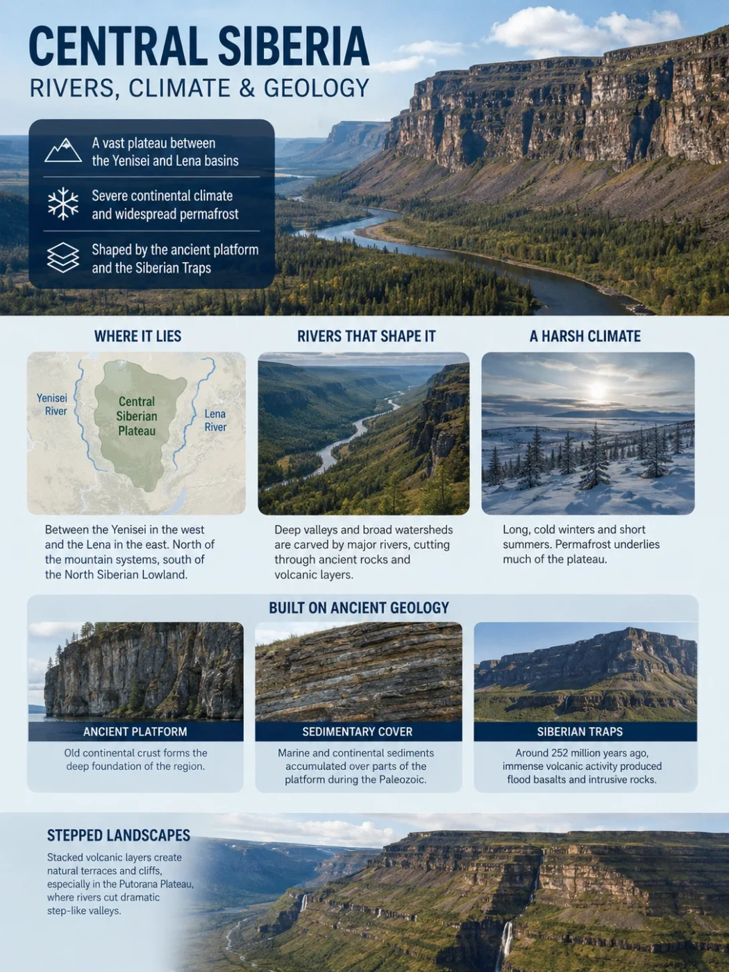
The Central Siberian Plateau is a vast upland between the Yenisei drainage in the west and the Lena basin in the east. Its surface is not a single flat table. Broad watersheds, stepped basalt uplands, ridges and deeply cut river valleys form a landscape shaped by an ancient continental platform, the Siberian Traps volcanic province, severe continental climate and widespread permafrost.
Yenisei–Lena Region
Siberian Traps
Widespread Permafrost
Where the Central Siberian Plateau Begins and Ends
The plateau occupies much of the elevated interior of central and eastern Siberia. The Yenisei River valley provides its clearest western boundary. To the east, the uplands descend toward the Central Yakutian Lowland and the Lena valley. The North Siberian Lowland lies beyond its northern edge, while mountain systems around the southern Siberian and Baikal region mark the transition away from the plateau in the south.
Many broad interior watersheds stand roughly 400–700 metres above sea level, but elevation varies greatly. The northwestern Putorana region rises above 1,600 metres and forms the highest, most strongly dissected part of the plateau system.
Geography Note
The Central Siberian Plateau is a physiographic region rather than an administrative unit. Published area figures can differ because geographic references do not always place its peripheral plateaus, ranges and adjoining lowlands within exactly the same boundary. The major river valleys and surrounding lowlands provide more useful geographic reference points than a single area figure.
The Geological Structure Beneath the Plateau
The plateau stands on the Siberian Platform, one of the old stable parts of the Eurasian continent. Its deeper foundation consists of ancient continental crust. Across much of the region, this basement is covered by younger sedimentary formations deposited during long intervals when different parts of the platform were occupied by shallow seas or sedimentary basins.
The geological feature that gives much of the plateau its distinctive character came much later. Around 252 million years ago, near the boundary between the Permian and Triassic periods, enormous amounts of magma moved through and across the Siberian Platform. This episode formed the Siberian Traps, one of Earth’s largest known large igneous provinces.
Old continental crust forms the deep structural foundation of the region.
Marine and continental sediments accumulated above parts of the platform during the Paleozoic Era.
Basaltic lava, volcanic material and intrusive magma spread through large parts of the region near the end of the Permian.
Flood Basalts and Intrusive Rock
The Siberian Traps were not created by one familiar cone-shaped volcano. Magma reached the surface through extensive fissure systems and produced repeated basalt flows. Large amounts of magma also remained underground, where it formed sills and other intrusive bodies within older sedimentary layers.
The Tunguska Basin was one of the main centres of this magmatic activity. In parts of the plateau, thick volcanic sequences now form broad elevated surfaces. Elsewhere, intrusive rocks cut through sedimentary formations below the surface.
Recent geological work on the Siberian Traps has placed more attention on these intrusive rocks. Magma entering sedimentary basins could heat surrounding carbonate, organic-rich and evaporite-bearing rocks, adding gases released from the magma itself. The timing of this magmatism closely overlaps the end-Permian environmental crisis about 252 million years ago.
Why Some Slopes Look Like Giant Steps
The term trap terrain is especially appropriate in places where erosion has exposed stacked resistant volcanic layers. Hard basalt, dolerite and related rocks may stand out as cliffs or benches, while weaker volcanic or sedimentary layers weather back more easily.
This pattern is especially clear in the Putorana Plateau. There, repeated volcanic layers have been cut by rivers into steep-sided valleys with a staircase-like profile. The present landscape is therefore not simply a preserved lava surface. It is a volcanic sequence that has been deeply modified by erosion.
Not All of the Plateau Is Basalt
The Siberian Traps dominate the geology of large western and northwestern sectors, but the Central Siberian Plateau should not be treated as one continuous basalt sheet. Sedimentary rocks, intrusive bodies and areas associated with older parts of the Siberian Platform also appear across the wider upland system.
Rivers Cut the Plateau Into Separate Uplands
Rivers are one of the main reasons the Central Siberian Plateau looks so different from a simple elevated plain. Long-term incision has divided the surface into plateaus, interfluves, ridges and valley networks. In places with resistant trap rock, rivers have cut narrow valleys and canyon-like reaches into otherwise broad uplands.
The regional drainage pattern is split mainly between the Yenisei system to the west, the Lena system to the east and rivers that flow directly north toward the Arctic seas.
| River | Drainage Role | Relationship to the Plateau |
|---|---|---|
| Yenisei | Major Arctic drainage trunk | Runs along the western side of the plateau and receives several large rivers draining its interior. |
| Lower Tunguska | Right-bank tributary of the Yenisei | Crosses a large part of the plateau and cuts deeply into the upland terrain before reaching the Yenisei. |
| Podkamennaya Tunguska | Right-bank tributary of the Yenisei | Drains southern and central sectors westward through dissected plateau country. |
| Angara | Major Yenisei tributary | Drains Lake Baikal westward and is closely tied to the southern margin and drainage structure of the plateau region. |
| Vilyuy | Major tributary of the Lena | Drains eastern parts of the plateau toward the Lena basin. |
| Olenyok | Independent Arctic river | Rises in the northern plateau region and flows toward the Laptev Sea rather than joining the Yenisei or Lena. |
The Lower Tunguska as a Plateau River
The Lower Tunguska is particularly useful for understanding the relief of Central Siberia. It travels for a long distance through plateau terrain before joining the Yenisei near Turukhansk. Its valley crosses areas of resistant rock, producing steep valley walls, exposed rock sections and sharply incised reaches.
Smaller tributaries repeat the same pattern at a finer scale. The Kochechum River, for example, cuts through the central plateau within a landscape of taiga, permafrost and broad upland divides. Satellite imagery shows how dense tributary networks dissect surfaces that can appear relatively even when viewed from a distance.
The Divide Between Yenisei and Lena Drainage
The plateau is also a major continental drainage divide. Water falling on its western and central slopes may eventually reach the Arctic Ocean through the Yenisei, while eastern drainage enters the Lena system through rivers such as the Vilyuy and its tributaries.
Farther north, some rivers follow separate routes toward the Arctic coast. This means the plateau is not one basin. It is an elevated source and transit region divided among several of northern Eurasia’s great drainage systems.
A Strongly Continental Climate
Central Siberia lies far from the moderating influence of warm oceans. This interior position produces a strongly continental climate with a very large seasonal temperature range. Winters are long and intensely cold, while summers are short and can become relatively warm in lower and more southerly parts of the plateau.
Conditions change considerably from south to north and with elevation. Northern uplands have a longer cold season and a shorter growing season. High parts of Putorana are colder than surrounding lowlands, while more southerly river valleys can warm much more strongly during summer.
Precipitation across much of the interior is moderate or low and is weighted toward the warmer part of the year. Relief changes this pattern. The Putorana uplands receive more moisture than many lower sections of the plateau, helping support their dense network of rivers, lakes and waterfalls.
Putorana Shows How Elevation Changes the Pattern
Climate measurements cited for the central Putorana region show a cold annual regime, with average January temperatures far below freezing and cool summers compared with southern Central Siberia. Its higher precipitation also separates it from many drier interior plateau areas. These values describe Putorana and should not be treated as averages for the entire Central Siberian Plateau.
Permafrost Controls the Ground Beneath the Rivers
Permafrost underlies much of the Central Siberian Plateau. Only the uppermost ground normally thaws during the warm season. This seasonally thawed zone is called the active layer.
The frozen ground below it changes the way water moves through the landscape. Rain and snowmelt cannot always infiltrate deeply, so water may travel laterally through shallow soil, organic layers and weathered rock toward streams. This helps create strong seasonal contrasts in river flow.
Water remains locked in snow and frozen ground through the long cold season.
Snowmelt releases a large pulse of water while much of the deeper ground is still frozen.
Permafrost restricts deep infiltration in many places and directs water toward channels through the active layer.
High seasonal discharge increases erosion along channels, valley floors and exposed rock sections.
Spring Is the Main Hydrologic Pulse
Many Central Siberian rivers respond strongly to snowmelt. Discharge rises rapidly during the spring and early summer freshet, then falls after the main snow supply has disappeared. Winter flow becomes much lower while rivers remain ice-covered for long periods.
This seasonality helps explain why large rivers can occupy valleys that seem oversized during low-water periods. Their geomorphic work is concentrated into much shorter intervals when meltwater and summer precipitation increase flow.
Frozen Ground Does Not Stop All Groundwater
Permafrost should not be pictured as a perfectly sealed frozen floor. Unfrozen zones called taliks can occur beneath rivers, lakes and other locations where local heat conditions prevent complete freezing. Water can also move through fractures and other connected pathways.
The balance between shallow runoff, groundwater and river flow therefore varies with permafrost thickness, vegetation, slope direction, rock type and the presence of unfrozen zones.
Current Permafrost Research
Recent modelling of a monitored forested headwater catchment in the continuous-permafrost zone of Central Siberia projects soil warming and a thicker seasonal active layer under multiple climate scenarios. The study also shows that slope orientation and vegetation can produce strong differences within the same small watershed. These results describe a particular catchment and should not be converted directly into a single plateau-wide thaw rate.
Why Different Parts of the Plateau Look So Different
The name Central Siberian Plateau can suggest one uniform surface, but its major sectors have different combinations of elevation, geology and erosion. Some contain thick trap sequences and steep valleys; others have lower, smoother watersheds or stronger exposures of sedimentary and older platform rocks.
Putorana contains the highest terrain, extensive basalt sequences, deeply cut valleys and numerous lake basins.
The Tunguska uplands combine trap rocks, sedimentary formations and major rivers flowing toward the Yenisei.
Vilyuy-facing uplands drain toward the Lena basin and gradually approach lower relief farther east.
Putorana Is the Most Rugged Expression
The Putorana Plateau forms the elevated northwestern end of the larger plateau system. Here, layered volcanic rocks have been strongly dissected. Rivers and streams have carved deep canyons, and long narrow lakes occupy major valleys and structural depressions.
This terrain shows the relationship between geology and erosion particularly clearly: resistant volcanic layers preserve high benches and cliffs while valleys expose long sequences of flood-basalt rocks.
The Tunguska Uplands Show the River–Trap Relationship
Farther south, the Tunguska region contains broad uplands cut by the Lower Tunguska, Podkamennaya Tunguska and their tributaries. Here the landscape often alternates between relatively subdued watershed surfaces and sharply incised valleys.
The contrast comes from millions of years of river erosion working across rocks with different resistance. Basaltic and intrusive rocks may form steep sections, while weaker sedimentary material is removed more readily.
How Rock, Frozen Ground and Water Produce the Modern Relief
The modern Central Siberian Plateau reflects several processes acting over very different timescales. The ancient Siberian Platform provided the continental foundation. Paleozoic sediments accumulated above it. Permian–Triassic magmatism then added vast quantities of volcanic and intrusive rock.
Afterward, uplift, weathering and river incision broke the broad surface into separate uplands. The cold climate added another control: permafrost restricted subsurface water movement across large areas and concentrated much of the annual runoff into a short thaw season.
Layered Rock Creates Uneven Resistance
Basalt, intrusive rocks, volcanic material and sedimentary formations weather at different rates.
Rivers Follow the Regional Slope
Drainage develops toward the Yenisei, Lena and Arctic coastal basins.
Seasonal Water Cuts Into the Surface
Snowmelt and summer rainfall supply strong pulses of runoff to river networks.
Repeated Incision Separates the Uplands
Valleys deepen while broad interfluves remain between them, producing the dissected plateau landscape seen across Central Siberia today.