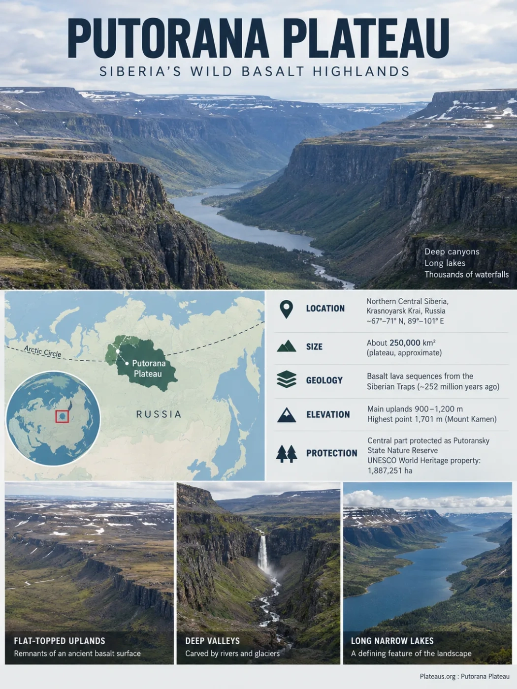
A Deeply Dissected Basalt Plateau in Arctic Siberia
The Putorana Plateau is the high, rugged northwestern part of the Central Siberian Plateau in Krasnoyarsk Krai, Russia. Its flat-topped basalt uplands are cut by deep canyons, long narrow lakes, cold rivers and thousands of waterfalls. Much of this landscape rests on lava sequences formed during the Siberian Traps eruptions around 252 million years ago, while its present relief was shaped much later by uplift, river incision, glaciation and cold-climate weathering.
Where Putorana Sits in Central Siberia
Putorana lies in northern Central Siberia, almost entirely north of the Arctic Circle. It forms the highest and most strongly dissected northwestern sector of the broader Central Siberian Plateau, rather than a separate plateau system of comparable continental scale.
The landform extends across a large, sparsely settled part of Krasnoyarsk Krai. Scientific descriptions commonly place it roughly between 67° and 71° N and 89° and 101° E, although the exact area assigned to the physical plateau depends on how its outer margins are defined.
The Plateau and the UNESCO Property Are Different Areas
Putorana Plateau is the physical landform. The Putoransky State Nature Reserve protects a central part of it, and the UNESCO World Heritage property follows the reserve boundary. UNESCO’s figure of 1,887,251 hectares therefore refers to the protected World Heritage property, not to the total area of the entire plateau.
| Area | What It Represents | Scale or Boundary |
|---|---|---|
| Putorana Plateau | The broader basaltic landform and mountain-like plateau region | Scientific literature often describes an area of roughly 250,000 km²; physical limits can vary by definition |
| Putoransky State Nature Reserve | A strictly protected reserve occupying the central plateau | Established in 1987 |
| UNESCO World Heritage Property | The protected World Heritage area, coinciding with the reserve boundary | 1,887,251 ha, with a 1,773,300 ha buffer zone |
Why a Plateau Can Look Like a Mountain Range
Photographs of Putorana often show steep valley walls, cliffs and isolated highlands rather than a broad flat plain. This does not conflict with its classification as a plateau. Putorana is a deeply dissected plateau: remnants of an elevated surface remain on the uplands, while rivers and glaciers have cut deeply into that surface.
Many interfluves and summit surfaces are broad or flat-topped. Scientific field descriptions place much of this elevated terrain around 900–1,200 metres above sea level. The highest part reaches about 1,701 metres at Mount Kamen. Far below the uplands, valleys cut through the basalt sequence and create large differences in local relief.
Broad remnants of the elevated basalt surface survive on flat or gently rolling uplands.
Successive resistant lava units appear as ledges and cliff bands on valley walls.
River incision, structural weaknesses and glacial erosion have cut far below the original upland surface.
The result is a landscape that may look mountainous from a valley floor even though its overall structure still preserves an elevated plateau surface. The combination of high table-like uplands and deep radial valleys is one of Putorana’s most recognizable landform patterns.
The Siberian Traps Beneath Putorana
Putorana’s geology belongs to the Siberian Traps large igneous province, one of the largest known continental flood-basalt provinces. The word traps comes from a term for steps or stairs and refers to the terraced appearance produced where stacked lava layers are exposed by erosion.
The plateau was not built by one central volcano. During the main Siberian Traps volcanic episode, enormous volumes of basaltic magma reached or intruded the crust across a much wider part of Siberia. Repeated lava flows accumulated in layers, accompanied in the larger province by pyroclastic deposits, dykes and extensive sill complexes.
Putorana exposes thick sequences dominated by tholeiitic basalt. Where valleys cut through these nearly layered volcanic rocks, resistant units form cliffs while weaker intervals weather back more easily. This is why many canyon walls show a conspicuous staircase profile.
Geological Time Scale
The major Siberian Traps magmatic pulse occurred close to the Permian–Triassic boundary, around 252 million years ago. Putorana’s modern canyons, lakes and waterfalls are much younger landforms carved into those ancient volcanic rocks.
Putorana and the End-Permian Mass Extinction
The broader Siberian Traps event overlaps in time with the end-Permian mass extinction, the largest known biological crisis of the Phanerozoic Eon. Modern research links the extinction to environmental disruption associated with the Siberian Traps magmatic system, including greenhouse-gas release and gases generated as magma intruded sedimentary rocks.
That connection applies to the entire Siberian Traps large igneous province. It would be misleading to describe the Putorana Plateau itself as the cause of the extinction. Putorana is one of the regions where rocks belonging to that much larger volcanic province are preserved and exposed.
How the Basalt Plateau Became Canyon Country
Volcanism supplied the rock foundation, but it did not create the present landscape by itself. Putorana’s modern form reflects a long sequence of structural movement, erosion and glaciation after the lava had solidified.
Successive Siberian Traps eruptions built a thick volcanic succession with broadly layered structure.
Later uplift raised the basaltic surface, while fractures and structural lines provided routes that drainage could exploit.
Streams incised into the uplifted plateau and progressively isolated flat-topped uplands between canyon systems.
Pleistocene glaciers widened and deepened valleys, carved cirques and altered drainage basins that later held lakes.
Glaciers Modified Rather Than Erased the Plateau
Putorana preserves a complex glacial history rather than the simple imprint of one continuous ice sheet. During colder Pleistocene stages, ice accumulated on the uplands and in mountain basins, while valley glaciers occupied parts of the deeply cut drainage system. Moraines, cirques and glacially modified valleys remain across the plateau.
A peer-reviewed 2026 morphometric study examined 200 cirques in western Putorana. Their dimensions and reconstructed ice geometry indicate a mature glacial landscape formed by prolonged erosion during cold stages of the Late Pleistocene. The reconstructed cirque glaciers had a median modelled ice thickness of about 55.9 metres, with the largest reconstruction reaching about 260.6 metres.
What the Cirques Show
Cirques are bowl- or amphitheatre-shaped hollows cut into mountain or plateau margins by glacier ice. Their widespread presence in western Putorana provides direct geomorphic evidence that glaciers repeatedly occupied high basins rather than merely passing across the landscape without modifying it.
Cold-Climate Processes Still Work on the Slopes
Permafrost and seasonal freezing continue to influence Putorana. Freeze–thaw weathering opens fractures in exposed basalt, while frost-driven soil movement affects less stable slopes. These processes help produce blocky debris, talus and other cold-region surface features, but they modify an older relief already established by uplift, rivers and glaciers.
Why Putorana Has So Many Lakes and Waterfalls
Water is one of the clearest expressions of Putorana’s relief. The plateau contains more than 25,000 lakes, together with countless cold-water streams and thousands of waterfalls. These features are closely tied to the deep valleys and large elevation differences cut into the basalt massif.
Long Lakes Occupy Deep Valleys
Many of the largest lakes are unusually long and narrow because they occupy deeply incised valleys. Lake Lama, Lake Keta, Lake Ayan and Lake Dupkun are examples of the elongated lake forms associated with the plateau’s canyon systems.
Glaciers altered several of these valleys during the Pleistocene. In the southwestern Putorana region, research on the Norilo–Pyasinskaya lake system shows that retreating glaciers deposited terminal moraines capable of damming drainage and influencing the development of lakes including Lama.
Why the Lakes Are Called Fjord-Like
Putorana’s long lakes are often described as fjord-like because narrow water bodies lie between steep valley walls. They are not marine fjords. Their similarity is one of shape and relief rather than a connection to seawater.
Basalt Steps Create Natural Waterfall Sites
The same layered geology that produces terraced canyon walls also favors waterfalls. Tributaries descending from high plateau surfaces cross resistant basalt ledges before entering much deeper trunk valleys. Large vertical differences can therefore be concentrated over short horizontal distances.
Snowmelt adds strong seasonal flow to many streams, making some waterfalls highly variable through the year. Ice also transforms numerous falls during the long winter, when water can freeze against the stepped canyon walls.
Waterfall Height Claims Require Caution
Talnikovy Waterfall is frequently described with superlatives such as the highest waterfall in Russia or Asia, but published height figures and measurement methods are inconsistent. The plateau’s abundance of waterfalls is well established; a single definitive ranking for Talnikovy is much less secure.
| Landscape Feature | Main Physical Control | Result |
|---|---|---|
| Deep canyon rivers | Long-term incision into an uplifted basalt surface | Large local relief and steep valley walls |
| Elongated lakes | Deep valleys modified by glacial erosion and, in some areas, moraine dams | Long, narrow water bodies with fjord-like outlines |
| Waterfalls | Tributaries crossing basalt ledges and entering deeper valleys | Frequent abrupt drops along canyon margins |
| Seasonal high flows | Accumulated winter snow and rapid thaw | Strong spring and early-summer discharge in many streams |
A Vertical Transition From Taiga to Arctic Uplands
Putorana lies near major ecological boundaries. Its position between the taiga and tundra biomes is combined with strong changes in elevation, slope exposure, snow cover and drainage. Vegetation can therefore change sharply over relatively short horizontal distances.
Northern taiga and larch-dominated woodland occupy the more sheltered low terrain.
Open woodland, shrubs, mosses and lichens form a shifting transition near the upper forest limit.
Treeless vegetation dominates exposed uplands where low temperatures and wind restrict tree growth.
Sparse high-Arctic vegetation and exposed basalt occur on the coldest and most exposed terrain.
These are ecological transitions rather than fixed elevation belts. A sheltered south-facing slope and a wind-exposed plateau edge at the same elevation can support different vegetation. Snow depth is also important because deep winter snow can protect plants from extreme cold while delaying spring thaw.
Research in the forest–tundra zone has documented changes in the upper tree limit, illustrating why Putorana is useful for studying how high-latitude vegetation responds to temperature, snow conditions and terrain.
Isolation Shapes Putorana’s Wildlife
The plateau’s remoteness, large protected core and varied relief support Arctic and subarctic fauna with relatively little direct modification of habitat. Two biological features are especially closely tied to Putorana’s geography: the isolated Putorana snow sheep population and the large-scale movement of wild reindeer.
Putorana Snow Sheep
The Putorana snow sheep is an isolated regional form of Asian snow sheep associated with the plateau’s cliffs, rocky slopes and broken uplands. Its separation from other snow sheep populations gives it particular biogeographic importance. The protected central plateau contains a large share of the known population.
A Major Reindeer Migration Corridor
Wild reindeer move across part of the plateau during large seasonal migrations. The importance of the route extends beyond any single reserve boundary because migrating animals depend on connected landscapes both inside and outside the protected property.
This movement is one reason Putorana’s remoteness matters ecologically. Roads, dense settlement and large infrastructure networks are absent from the World Heritage property, allowing broad landscape-scale processes to continue with comparatively little fragmentation.
Why the Central Plateau Is a World Heritage Site
The central Putorana Plateau was inscribed on the UNESCO World Heritage List in 2010 under natural criteria (vii) and (ix). The protected property covers 1,887,251 hectares and is surrounded by a buffer zone of 1,773,300 hectares.
Criterion VII
Basalt Canyons, Lakes and Waterfalls
The protected area contains an extensive layered basalt landscape cut by deep canyons, together with more than 25,000 lakes, thousands of waterfalls and large areas with little visible infrastructure.
Criterion IX
Arctic and Subarctic Ecological Processes
The property spans the tundra–taiga boundary and the transition between western and eastern Siberian floristic regions, while also protecting wildlife movements and strong altitudinal ecosystem changes.
The World Heritage boundary coincides with the Putoransky State Nature Reserve. There are no roads within the property and across large parts of its buffer zone. This lack of infrastructure is not merely a travel constraint; it helps maintain the continuity of ecosystems, river systems and animal migration routes.
Current Condition and Pressures
The 2024 UNESCO periodic reporting cycle assessed the main landscape attributes of the property—including the Arctic and boreal landscape, layered basalt canyons, extensive lake and waterfall systems and the Putorana snow sheep habitat—as preserved.
The same reporting process identifies pressures that still require monitoring. Wildfire can disturb both Arctic and boreal landscapes. Climate-related changes are relevant to large natural Arctic ecosystems, while uncontrolled visitation can increase the risks of fire, littering and local disturbance in the World Heritage property and its buffer zone.
Visitor management exists, but the 2024 assessment indicates that implementation and monitoring can be improved. Management priorities include stronger surveillance of vulnerable locations, monitoring of tourist flows, wildfire risk assessment and continued research into climate-related ecological change.