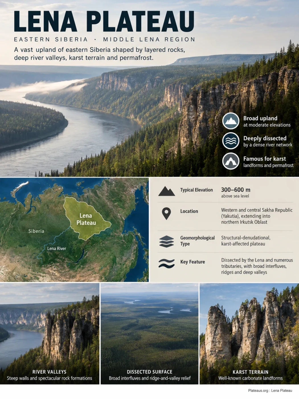
Eastern Siberia · Middle Lena Region
The Lena Plateau, also known as the Prilenskoye Plateau, is a broad upland of eastern Siberia shaped less by extreme altitude than by its layered sedimentary rocks, deeply cut river network, karst terrain and permafrost. Much of its surface lies at moderate elevations, yet river incision exposes steep valley walls and some of the best-known carbonate landforms along the middle Lena.
Structural-denudational plateau
Karst and permafrost terrain
Where the Lena Plateau Sits in Siberia
The Lena Plateau occupies a large part of the southeastern sector of the Central Siberian Plateau region, extending through western and central parts of the Sakha Republic (Yakutia) and into northern Irkutsk Oblast. Its name comes from the Lena River, whose middle course is closely tied to the plateau’s geography.
Russian geomorphological classifications place the Prilenskoye Plateau within a belt of structural-denudational, karst-affected plateaus. It is not an isolated tableland surrounded by abrupt escarpments. Its margins grade into other plains, plateaus and uplands, while major rivers cut through or along the regional surface.
Southeastern part of the Central Siberian Plateau region
Broad dissected upland centered on the middle Lena region
Transition toward the Central Yakutian plains and terraces
Boundary Note
The Lena Plateau is a physiographic landform rather than an administrative unit. Its edge is therefore better understood as a transition between terrain systems than as a sharply surveyed boundary. Different regional maps may generalize that transition differently.
A Plateau of Moderate Elevation but Strong Local Relief
The Lena Plateau is a useful example of why a plateau does not have to be extremely high. Geological and geomorphological studies of its structural-denudational terrain commonly describe elevations of roughly 300–600 m above sea level. River valleys lie lower, while divides and ridge-like surfaces rise above them.
Those numbers should not be treated as one fixed elevation for the entire landform. The plateau covers a very large and internally varied region, and elevation changes toward adjoining uplands, lowlands and major valleys.
Why It Still Qualifies as a Plateau
Plateau classification depends on the form and regional position of the land surface, not on reaching a particular altitude. Across the Lena Plateau, remnants of an elevated sedimentary surface remain recognizable between river valleys. Erosion has cut that surface into broad interfluves, low ridges and dissected blocks, rather than destroying its regional continuity.
This creates an important difference between map scale and ground-level appearance. On a regional elevation map the plateau appears as an extensive elevated surface. Along a deeply incised river, the same terrain can resemble a sequence of wooded ridges, steep slopes and rock walls.
Why the Surface Is So Heavily Dissected
The Lena Plateau is not a smooth slab of high ground. A dense drainage network has cut into its sedimentary surface, separating divides and producing a largely ridge-and-valley relief in many sectors.
The Lena itself is only part of this system. Numerous tributaries and smaller watercourses drain the plateau, and their valleys range from broad terraced corridors to narrow, more sharply incised channels. Smaller streams can form V-shaped valleys where they cut rapidly through bedrock, while the largest rivers have wider floodplains and several levels of river terraces.
The result is a landscape in which the original plateau character is often easiest to recognize on the interfluves. The valleys expose the depth of erosion that has taken place below those surviving surfaces.
Broad or gently rolling remnant of the elevated plateau surface
Bedrock slopes, ravines and locally exposed carbonate cliffs
Channel, floodplain and terrace levels cut below the surrounding upland
Layered Paleozoic Rocks Control Much of the Landscape
The physical character of the Lena Plateau is closely connected to the sedimentary cover of the Siberian Platform. Studies in the plateau region describe extensive Cambrian and Ordovician strata, including limestone, dolomite, marl, sandstone, siltstone and locally gypsum-bearing rocks.
Carbonate rocks are especially important because limestone and dolomite respond differently to water and frost than many resistant crystalline rocks. Fractures allow water to enter the bedrock. Dissolution enlarges some of those openings, while repeated freezing, thawing and mechanical weathering widen others.
Different rock units also weather at different rates. This helps produce stepped slopes, resistant ridges, exposed cliffs and irregular valley walls instead of one uniform erosional surface.
The Plateau Is Not a Simple Horizontal Rock Layer
Although broad areas consist of layered platform sediments, tectonic structures also influence the relief. Some studied parts of the plateau contain elongated folds and ridge-like structural forms. Rivers then cut across or between these structures, adding another level of relief complexity.
For that reason, describing the Lena Plateau simply as a flat pile of sedimentary rocks misses much of its actual morphology. Rock type, geological structure and erosion work together to determine which surfaces persist and where valleys deepen.
Karst Extends Beyond Caves and Sinkholes
Karst is one of the defining processes in carbonate sectors of the Lena Plateau. Dissolution of limestone and dolomite creates a collection of surface and underground forms rather than a single type of feature.
Surface Karst
Depressions and Sink-Like Forms
Closed or partly closed depressions develop where soluble bedrock is lowered by dissolution, subsidence or a combination of processes.
Subsurface Drainage
Ponors, Fissures and Cavities
Water can enter fractured carbonate rock through openings rather than remaining entirely in surface channels.
Bedrock Exposure
Niches, Small Caves and Irregular Cliffs
Weathering and dissolution exploit joints and bedding planes where river incision exposes the rock.
Karst development is particularly interesting here because it operates in a cold-region environment. The Lena Plateau is therefore not a direct analogue of warm, humid limestone landscapes where chemical dissolution dominates throughout the year.
Permafrost Changes Both Drainage and Weathering
Large parts of the Lena Plateau lie within permafrost terrain. Permanently frozen ground can extend far below the shallow surface layer that thaws seasonally, although its thickness and continuity vary across the region.
Permafrost does not stop water movement. Instead, it reorganizes it. Frozen material can act as a low-permeability barrier, concentrating water in the seasonally thawed layer or directing it through taliks—zones of unfrozen ground within or beneath permafrost. Where fractures and karst cavities remain hydraulically connected, groundwater can still move through carbonate bedrock.
Limestone and dolomite contain joints and other pathways for water.
Meltwater and rainfall enter fractures during the thawed season.
Dissolution, freezing and thawing enlarge or modify weaknesses in the rock and ground.
River incision, slope processes, karst and permafrost landforms operate together.
Thermokarst Adds a Different Type of Depression
Not every depression in the Lena Plateau region is produced by dissolving limestone. Thermokarst develops where ice-rich permafrost thaws and the ground settles. Karst and thermokarst can therefore occur within the same broader landscape while having different mechanisms.
This distinction matters in central Yakutia, where frozen-ground processes can produce subsidence basins, ice-related mounds and other forms alongside conventional carbonate karst.
The Lena River Exposes the Plateau From the Inside
The Lena River is more than the feature that gives the plateau its name. Its valley and tributary valleys provide some of the clearest exposures of the plateau’s bedrock and erosional structure.
Where rivers cut deeply enough, the forest-covered surface gives way to visible layers of carbonate and other sedimentary rock. Floodplains and river terraces occupy lower levels, while older surfaces remain higher above the modern channel. This vertical separation records repeated phases of valley development rather than a single episode of erosion.
The contrast can be pronounced: relatively subdued upland terrain may sit only a short horizontal distance from steep rock faces overlooking a major river valley. That is one reason ground photographs can give a misleading impression of the plateau as a predominantly cliff-lined landscape.
The Lena Pillars Are Part of the Story, Not the Plateau Itself
The best-known rock landscape associated with the middle Lena is the Lena Pillars. The protected area along the river contains major exposures of Cambrian carbonate rocks and tall, narrow rock buttresses separated by steep gullies.
At the Lena Pillars Nature Park, individual rocky buttresses can reach roughly 200 m in height. Frost shattering along joints, water penetration, karst processes and river erosion all contribute to their form. The protected area also preserves an important Cambrian fossil record and was inscribed on the UNESCO World Heritage List in 2012.
Do Not Treat the Names as Synonyms
Lena Plateau refers to a much larger regional landform. Lena Pillars refers to a specific rock landscape and protected area along the middle Lena River. The pillars illustrate processes operating within the wider geological setting, but they do not define the full extent or appearance of the plateau.
The same caution applies to local permafrost measurements. In the Lena Pillars area, permafrost has been documented at several hundred metres in thickness, with values around 400–500 m reported for parts of the protected property. Those measurements describe that specific sector and should not be presented as a uniform thickness for the entire Lena Plateau.
Taiga Hides Much of the Bedrock Surface
Much of the plateau is covered by taiga and permafrost-taiga landscapes. Larch is widespread, while forest density, wetlands and open ground vary with drainage, slope position, soil conditions and the local state of permafrost.
Flat or weakly sloping terrain can retain water where frozen ground restricts downward drainage. Marshy areas are therefore common in some sectors. River valleys may contain small meadow areas and better-drained terraces, creating a landscape pattern that differs from the surrounding interfluves.
Vegetation can make the plateau appear smoother from satellite imagery than its underlying geology would suggest. Bedrock becomes most visible where rivers, ravines, erosion or karst have removed the soil and forest cover.
Three Processes Explain Much of the Present Relief
Layered Cambrian and Ordovician rocks, folds, joints and differences in rock resistance guide the broad form of ridges, slopes and exposed bedrock.
The Lena drainage system cuts below older plateau surfaces, separating interfluves and exposing sedimentary strata in valley walls.
Dissolution, frost weathering, permafrost hydrology and thermokarst modify both bedrock and unconsolidated surface material.
None of these processes alone explains the landscape. The recognizable Lena Plateau is the product of an old sedimentary platform surface being progressively modified by erosion, drainage, karst and cold-climate ground processes.
Lena Plateau and Lena–Angara Plateau Are Separate Landforms
The similarity of the names causes frequent confusion. Lena Plateau and Lena–Angara Plateau are not alternative English names for the same feature. Russian national geomorphological classification lists Prilenskoye Plateau and Leno-Angarskoye Plateau as separate plateau units within the broader Central Siberian system.
Lena Plateau
- Also called the Prilenskoye Plateau.
- Closely associated with the middle Lena region.
- Extends across parts of Yakutia and northern Irkutsk Oblast.
- Large sectors form a moderate-elevation structural-denudational and karst plateau.
- Permafrost, river incision and carbonate terrain are major landscape controls.
Lena–Angara Plateau
- Known in Russian as the Leno-Angarskoye Plateau.
- Centered farther southwest in Irkutsk Oblast.
- Associated with the country between the Angara and upper Lena drainage systems.
- Includes substantially higher terrain in its southern sectors.
- Mapped as a distinct geomorphological plateau rather than a subdivision or synonym of the Lena Plateau.
A third similarly named feature, the Lena–Aldan Plateau, is also treated separately in Russian geomorphological mapping. Keeping these names distinct is important because each refers to a different physical unit even though all belong to the wider geography of the Lena basin and eastern Siberia.