INTERACTIVE CONTEXT MAP
Where is Antarctic Plateau?
The selected plateau and nearby mapped locations are shown. Open the full world atlas to explore every region.
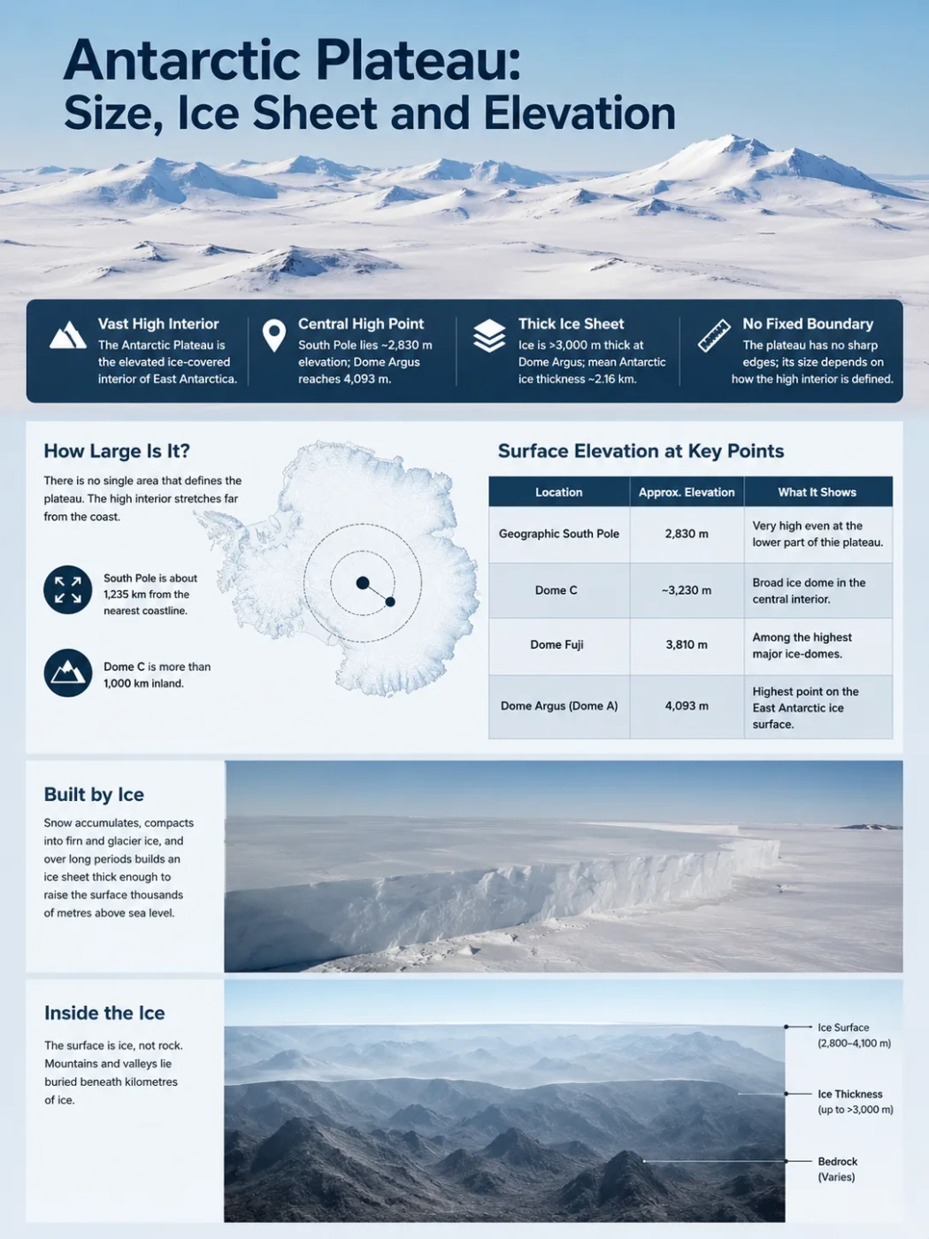
The Antarctic Plateau is the broad, high interior of Antarctica where the surface of the ice sheet rises thousands of metres above sea level. It includes the geographic South Pole and reaches its greatest ice-surface elevation at Dome Argus, or Dome A, at 4,093 m. The plateau looks like a vast plain, but most of that visible surface is ice rather than exposed bedrock.
South Pole: about 2,830 m
Dome A: 4,093 m
Ice more than 3 km thick at Dome A
What the Antarctic Plateau Actually Includes
The name Antarctic Plateau, also commonly used as Polar Plateau or East Antarctic Plateau, refers to the elevated inland ice surface rather than to a sharply bounded block of exposed rock. Its central high ground occupies much of the interior of East Antarctica and extends into the South Pole region.
This makes the feature different from many familiar plateaus on other continents. A rocky plateau may have edges that can be traced from cliffs, escarpments or mapped geological boundaries. The Antarctic Plateau grades outward through the sloping surface of the ice sheet, so its outer limit depends on how a map or study defines the high interior.
Why Its Size Is Hard to State as One Area
There is no single, universally used polygon that gives the Antarctic Plateau a fixed area in square kilometres. Descriptions of its size are therefore better read as descriptions of the broad high interior, not as a surveyed boundary comparable with a country or an administrative region.
How Large Is the Antarctic Plateau?
The plateau is continental in scale, but quoting one precise area can create false accuracy. A better sense of its dimensions comes from the distances within the high interior. The geographic South Pole lies about 1,235 km from the closest coastline, while Dome C is more than 1,000 km inland. These are not measurements of a plateau boundary, but they show how far the elevated ice interior reaches away from the coast.
The Antarctic Plateau should also not be treated as another name for all of East Antarctica. East Antarctica includes coastal slopes, mountain ranges, outlet-glacier systems and lower ice-sheet margins as well as the central plateau. The plateau is the high inland part of that larger region.
Elevation Rises Toward the Interior Ice Domes
Surface elevation across the plateau is not uniform. The geographic South Pole stands at roughly 2,830 m above sea level, while several major ice domes farther into East Antarctica rise well above 3,000 m. These domes are broad high points in the ice sheet rather than conventional rocky mountain summits.
| Location | Approximate Surface Elevation | What It Shows |
|---|---|---|
| Geographic South Pole | 2,830 m | The plateau remains very high even where it is lower than the main East Antarctic domes. |
| Dome C | About 3,230 m | A broad ice dome in the central East Antarctic interior. |
| Dome Fuji | 3,810 m | One of the highest major ice-dome areas on the plateau. |
| Dome Argus (Dome A) | 4,093 m | The highest point on the East Antarctic ice surface. |
The numbers above are ice-surface elevations. They do not tell how high the solid ground lies beneath the ice. That distinction is essential when describing the Antarctic Plateau.
The Plateau Surface Is Built by the Ice Sheet
The Antarctic Plateau owes much of its present height and smooth appearance to the East Antarctic Ice Sheet. Snow accumulates, compacts into firn and then into glacier ice. Over very long periods, this produces an ice mass thick enough to bury most of the underlying landscape.
Across Antarctica as a whole, the ice sheet has a mean thickness of about 2.16 km. The high East Antarctic interior can be thicker than that. At Dome Argus, for example, the ice is more than 3,000 m thick.
The visible plateau surface measured by satellite and ground elevation surveys.
Thousands of metres of compacted snow and glacier ice in parts of the interior.
Rocky terrain containing mountains, valleys, basins and other relief hidden below the ice.
For that reason, describing the Antarctic Plateau as simply a high bedrock plateau is misleading. The modern landform seen at the surface is a combined product of the underlying continent and the enormous thickness and shape of the ice resting on it.
A Flat-Looking Surface Can Hide Mountainous Bedrock
One of the clearest examples lies beneath Dome A. Its gently shaped ice surface sits above the Gamburtsev Subglacial Mountains, a buried mountain system in the interior of East Antarctica. More than 3 km of ice covers parts of this terrain.
Modern radar surveys and continent-wide mapping separate three measurements that can look interchangeable on a simple map: surface elevation, ice thickness and bed elevation. Bedmap3, released in 2025, combines updated measurements of all three and adds much denser survey coverage across parts of the deep East Antarctic interior.
Surface Elevation
Height of the top of the snow or ice above sea level. This is the measurement that makes Dome A a 4,093 m high point.
Ice Thickness
Vertical distance between the ice surface and the bed beneath it. It can exceed 3,000 m in the Dome A region.
Bed Elevation
Height or depth of the solid ground below the ice. It reveals buried mountains, troughs and basins that are invisible at the surface.
The High Plateau Is an Ice-Flow Divide
An ice sheet does not remain motionless simply because its interior looks flat. Gravity drives ice away from the high central regions toward lower elevations. Near ice-sheet summits and divides, the slope is very gentle and movement can be only a few centimetres to a few metres per year. Farther downslope, ice is channelled into faster-moving glaciers and ice streams.
Low snowfall builds layer by layer and gradually compacts into ice.
The thick interior ice sheet creates broad high points such as Dome A, Dome C and Dome Fuji.
Flow spreads away from divides toward lower parts of the ice sheet and eventually toward outlet-glacier systems.
The plateau is therefore not just a topographic high. It is part of the geometry that controls how the East Antarctic Ice Sheet drains. Small differences in surface slope can separate ice moving toward different sectors of the coast.
Why the Elevation Produces Such Extreme Conditions
High latitude already limits incoming solar energy, and the plateau adds another factor: altitude. Much of the interior sits between roughly 3,000 and 4,000 m above sea level. The air is thin, very cold and exceptionally dry. The amount of moisture reaching the polar plateau is comparable with precipitation in hot deserts.
The high domes can be colder than lower parts of the plateau. Dome Fuji, at 3,810 m, has an annual mean temperature below −50°C. The East Antarctic high ridge between Dome Argus and Dome Fuji is also where satellite observations have found some of the lowest snow-surface temperatures on Earth.
Low accumulation is one reason deep ice cores from plateau sites are so valuable. Snow layers can preserve long records while the great thickness of inland ice allows drilling far back through time. Dome Fuji and Dome C have both become major sites for research based on deep ice cores.
Reading the Antarctic Plateau Correctly on Elevation Maps
On a normal surface-elevation map, the Antarctic Plateau appears as a broad high zone with gentle gradients. That view is accurate for the top of the ice but incomplete for the continent underneath. A bed-elevation map can show rugged mountains and deep basins in places where the surface map looks almost featureless.
- Use surface elevation to understand the height and shape of the visible plateau.
- Use ice-thickness data to see how much frozen material separates the surface from the ground.
- Use bed elevation to understand the buried geological landscape.
- Do not use the outline of East Antarctica as if it were the boundary of the Antarctic Plateau.
This three-layer view explains the central geographic fact of the Antarctic Plateau: its immense height is real, but much of that height belongs to the ice sheet. The solid continent beneath it has a far more varied relief than the smooth white surface suggests.