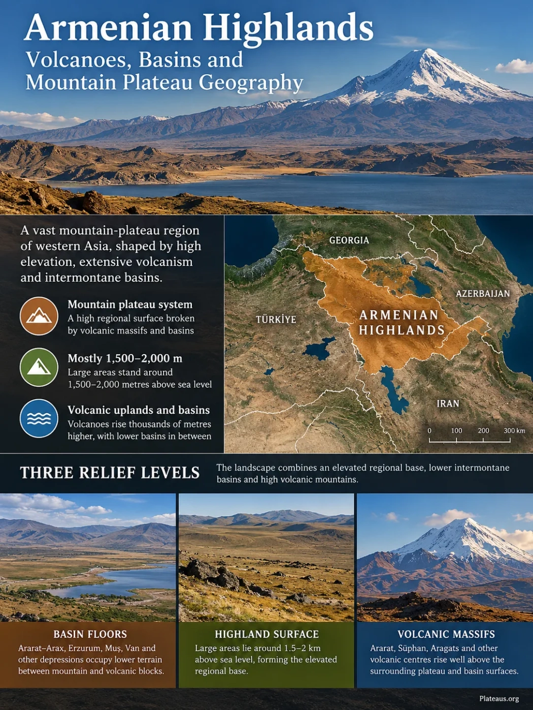
The Armenian Highlands form a broad mountain-plateau region of western Asia where a high regional surface is broken by volcanic massifs, lava-covered uplands, fault-bounded depressions and large lake basins. Much of the terrain stands roughly 1,500–2,000 metres above sea level, while major volcanoes rise thousands of metres higher. The result is not one flat plateau but a layered highland in which uplift, volcanism and basin formation have produced sharp relief contrasts over relatively short distances.
Mostly 1,500–2,000 m regional elevation
Volcanic uplands and intermontane basins
A Highland Larger Than Modern Armenia
Armenian Highlands, also called the Armenian Highland or Armenian Plateau, is a physical-geographic term rather than the name of a modern political unit. Its commonly described extent reaches across much of eastern Türkiye and Armenia and, depending on the boundary definition, into southern Georgia, western Azerbaijan and northwestern Iran.
Widely cited physiographic descriptions place the highland at roughly 400,000 km², with much of its regional surface around 1,500–2,000 metres above sea level. That area should be treated as an approximation. Natural highland margins grade into the Lesser Caucasus, Anatolian uplands, Iranian Plateau and surrounding mountain belts, so different maps do not always draw the same outer line.
Geography Note
The Armenian Highlands and the Republic of Armenia are not interchangeable terms. Armenia occupies part of the highland, while the physical region extends well beyond the country’s present borders.
The regional name also overlaps with several narrower geomorphic terms. The Eastern Anatolian Plateau describes a large high-standing part of eastern Türkiye within the wider collision zone. The Erzurum–Kars Plateau is a smaller volcanic high plateau within northeastern Anatolia. The Armenian Volcanic Highland is used in geological research for volcanic terrain centred farther east in the southern Lesser Caucasus. These units overlap geographically but operate at different scales.
The Landscape Is Built in Three Relief Levels
The highland makes more sense when elevation is separated into three layers rather than reduced to a single average value. Broad elevated surfaces form the regional base. Intermontane basins sit lower within that base, while large volcanic mountains rise far above it.
Ararat–Arax, Erzurum, Muş, Van and other depressions occupy lower terrain between mountain and volcanic blocks.
Large areas lie around 1.5–2 km above sea level, forming the elevated regional base on which other landforms are superimposed.
Ararat, Süphan, Aragats and other volcanic centres rise well above the surrounding plateau and basin surfaces.
This vertical arrangement explains why the Armenian Highlands can look mountainous while still functioning as a plateau-scale landform. A volcano rising to more than 4,000 or 5,000 metres is not evidence that the whole region has that elevation. It is a high edifice standing on an already elevated landscape.
Much of the Eastern Anatolian part has rolling, relatively low-relief upland surfaces near 2,000 metres, yet those surfaces are repeatedly interrupted by cones, ridges, fault scarps, valleys and depressions. The relief therefore combines high regional elevation with strong local differences in height.
Collision Raised the Regional Base
The high elevation developed within the broad Arabia–Eurasia collision zone. Continued convergence shortened and thickened the crust across eastern Anatolia and adjoining highlands during the Neogene, raising a large area rather than producing only a narrow mountain chain.
Recent tectonic reconstructions give crustal shortening a major role in raising the Eastern Anatolian Plateau. The region has absorbed hundreds of kilometres of convergence since the Miocene, and crustal thickness locally reaches roughly 45 km. This distributed deformation helps explain why a broad area stands close to 2 km above sea level.
The deeper structure is not uniform across the whole highland. Seismic studies beneath the Armenian volcanic highland also indicate locally thinned mantle lithosphere, anomalous lower-crustal conditions and evidence consistent with partial melt. Lithospheric removal, hot asthenospheric material and crustal magmatic processes can therefore contribute to elevation and volcanism in some sectors without replacing crustal shortening as the regional tectonic story.
Arabia moves northward relative to Eurasia, deforming a broad zone rather than a single fault line.
Compression raises the regional surface and creates folds, faults, mountain blocks and basins.
Removal or thinning of mantle lithosphere in some sectors allows hotter material to rise beneath the crust.
Magma reaches the surface across parts of the highland, adding lava plateaus, cones, domes, calderas and volcanic fields.
This combination matters because the highland was not simply a flat surface that was lifted and left unchanged. Uplift, faulting, basin subsidence and volcanic construction continued to modify the relief after the regional elevation had begun to rise.
Volcanoes Built a Second Landscape Above the Plateau
Volcanism is one of the clearest differences between the Armenian Highlands and many erosion-dominated plateaus. Large parts of the region contain Pliocene and Quaternary volcanic rocks, while several volcanic systems remained active into the Holocene or historical time.
The volcanic landforms are also varied. Ararat and Süphan are steep composite volcanoes. Tendürek is a much broader shield volcano. Nemrut combines a large volcanic edifice with a summit caldera. Farther northeast, the Gegham Volcanic Ridge is a field of many vents, cones, domes and lava flows rather than one dominant cone.
| Volcanic Feature | Landform | Approximate Elevation | Known Eruptive Age | Role in the Landscape |
|---|---|---|---|---|
| Greater Ararat | Composite stratovolcano | About 5,140 m; published values vary slightly by dataset | Historical activity recorded in 1840 | Highest volcanic massif in the highland and an extreme example of relief above the regional surface |
| Süphan | Composite stratovolcano with domes, cones and maar features | About 4,030 m | Last known activity is Pleistocene | Forms a dominant high massif immediately north of the Lake Van basin |
| Tendürek | Shield volcano | About 3,510 m | Historical activity recorded in 1855 | Creates broad lava-built relief between the Lake Van and Ararat sectors |
| Nemrut | Composite volcano with summit caldera | About 2,950 m | Confirmed historical activity into the 17th century | Closely linked to the development of the closed Lake Van drainage basin |
| Aragats | Large composite volcanic massif | About 4,095 m | Youngest flows are not precisely dated | Forms one of the largest high volcanic masses in Armenia |
| Gegham Volcanic Ridge | Volcanic field | Highest vents around 3,600 m | Holocene activity; latest listed eruption about 1900 BCE | Shows how clusters of vents and lava flows can build an upland rather than a single mountain |
Ararat shows the contrast particularly well. Its summit reaches a little over 5.1 km above sea level, but the volcano rises from a high continental interior rather than from a low coastal plain. Tendürek produces a different profile: its broad shield spreads lava over a wide area instead of concentrating most of its volume into a steep cone.
The Gegham Volcanic Ridge offers another scale of volcanic construction. West of Lake Sevan, dozens of volcanic centres, lava domes and pyroclastic cones form a volcanic field about 65 km long. Some lava flows reached the margins of Lake Sevan, showing that volcanism has modified basin edges as well as mountain summits.
Landform Note
A volcanic summit elevation should not be used as the elevation of the plateau itself. The Armenian Highlands contain basin floors, plateau surfaces, ridges and volcanic summits at very different heights within the same regional landform system.
Nemrut and Lake Van Show How Volcanism Can Reorganize Drainage
Lake Van occupies a tectonic depression in eastern Türkiye, but tectonics alone do not explain why the basin has no outlet today. Volcanic growth at Nemrut altered the western side of the drainage system and helped separate the Van depression from the Muş–Murat river system.
An older simplified explanation described the lake as the result of a single lava flow damming an ancestral outlet. More detailed work supports a broader process in which growth of the Nemrut volcanic complex progressively plugged the connection between the Van basin and the lower terrain to the west. The modern lake therefore records an interaction between a pre-existing tectonic basin and later volcanic construction.
Lake Van now forms a closed, or endorheic, basin. Streams bring water and dissolved minerals into the lake, but there is no permanent surface river carrying that water onward to another basin. Water is removed mainly by evaporation, helping produce the lake’s strongly alkaline soda-water chemistry.
Nemrut itself contains an approximately 8.5 × 7 km summit caldera. Its history includes large explosive eruptions, ignimbrite emplacement, lava flows and later activity inside the caldera. Volcanic products from Nemrut are also preserved as tephra layers in Lake Van sediments, allowing eruptions to be compared with the lake’s long sedimentary record.
Faulting and crustal deformation created accommodation space for the Van basin.
Growth of the Nemrut volcanic complex altered the basin’s western drainage connection.
With no permanent surface outlet, inflow terminates in Lake Van and water loss is dominated by evaporation.
Ash and other volcanic material preserved in lake sediments record repeated eruptions from surrounding volcanic centres.
Van, Sevan and Urmia Occupy Different Kinds of Highland Basin
Three large lakes help reveal how differently water behaves inside the Armenian Highlands. Lake Van and Lake Urmia are terminal basins with no permanent outlet to the sea. Lake Sevan, despite occupying a high mountain basin, has an outlet through the Hrazdan River and ultimately belongs to the Aras drainage system.
| Lake | Basin Type | Surface Outlet | Water Character | What the Basin Shows |
|---|---|---|---|---|
| Lake Van | Endorheic tectonic-volcanic basin | None | Strongly alkaline soda lake | Volcanism can close or reorganize an already existing tectonic drainage basin |
| Lake Sevan | High mountain basin with external drainage | Hrazdan River | Freshwater | A high basin does not have to be internally drained |
| Lake Urmia | Endorheic tectonic basin | None | Saline | Terminal drainage and strong evaporation can concentrate salts within an interior depression |
Lake Sevan is especially useful for avoiding a common simplification. Its surface lies around 1,900 metres above sea level, yet elevation alone does not make it an endorheic lake. Water leaves through the Hrazdan, although modern regulation has strongly altered the natural water balance and discharge regime.
Lake Urmia represents the opposite drainage condition. It occupies an enclosed basin in northwestern Iran, and water reaching the lake has no river route to an ocean. Its shoreline and surface area can change greatly as the water balance changes, so a single modern lake-area figure should not be treated as a permanent measure of the underlying basin.
The Basins Are Part of the Plateau, Not Gaps Between It
Intermontane depressions are as characteristic of the Armenian Highlands as its volcanic mountains. They formed where tectonic deformation created lower structural zones while adjacent blocks and volcanic areas remained higher. Sediment then accumulated on many basin floors, producing plains that contrast sharply with the surrounding mountains.
Ararat–Arax Depression
The broad lowland along the Aras River forms one of the clearest relief contrasts in the region. Greater Ararat and other uplands rise abruptly above a comparatively low basin floor. The depression also provides an east–west drainage corridor through terrain that is otherwise strongly compartmentalized by mountains and volcanic masses.
Erzurum Basin
The Erzurum area shows how an open plain can sit inside a high plateau system. Basin-floor sediment and relatively gentle terrain occupy a depression surrounded by higher volcanic and mountain surfaces. Its presence does not interrupt the larger plateau identity; it is part of the relief architecture that gives the highland its broken form.
Muş Basin
West of the Lake Van sector, the Muş depression occupies lower terrain within the upper Euphrates drainage. Its relationship with the Van basin is especially useful because volcanic growth around Nemrut helped separate two neighbouring drainage systems that once had a closer geomorphic connection.
Van and Sevan Basins
Both contain major lakes, but their drainage histories differ. Van is internally drained, whereas Sevan releases water through the Hrazdan. The contrast shows why basin shape, outlet elevation, fault structure and volcanic barriers matter more than the presence of a lake alone.
The Highland Is a Major Water Divide
The Armenian Highlands sit across several large drainage systems. Water falling on neighbouring high surfaces can eventually reach entirely different terminal basins or seas.
Western and southwestern highland drainage joins the Euphrates system and continues toward Mesopotamia and the Persian Gulf.
Southern highland margins feed tributaries that descend toward the Tigris basin.
Northern and eastern sectors drain through the Kura and Aras systems toward the Caspian Sea.
Lake Van and Lake Urmia receive water from surrounding uplands but do not export it through permanent surface rivers.
The divide is not one continuous knife-edge ridge. It shifts across volcanic plateaus, mountain chains and basin rims. A lava field can redirect a stream, tectonic uplift can steepen one side of a divide, and river incision can gradually move a watershed through headward erosion.
This drainage pattern also explains why lakes only a few hundred kilometres apart can have very different chemistry. An outlet continually removes dissolved material from a basin. A closed basin retains much of that material while evaporation removes water, allowing salts or carbonates to become concentrated.
Young Volcanic Surfaces Sit on an Older Collision Zone
Much of the volcanic relief visible today is geologically young compared with the older rocks incorporated into the mountain belt. Volcanic activity expanded widely during the Neogene and Quaternary, covering older structures with lava, tuff and other volcanic deposits.
Some volcanic surfaces are young enough to retain cones, craters and lava-flow forms that erosion has not yet erased. Research on Armenian volcanic terrain describes many slopes as products mainly of Pliocene–Quaternary volcanism. Their form depends partly on whether they consist of resistant lava, loose pyroclastic material or alternating volcanic units with different permeability and erosion rates.
Holocene and historical eruptions show that the region’s volcanism cannot be treated simply as a remote ancient event. The volcanic record includes historical activity at Ararat, Tendürek and Nemrut, while Holocene centres occur farther east around the Gegham Ridge, Porak and other parts of Armenia.
Eruption-Age Note
“Young volcanic landscape” does not mean every volcano is currently active or equally hazardous. Süphan, for example, has no known Holocene eruption in the main global volcanological catalogue, while Tendürek, Ararat and Nemrut have documented or catalogued historical activity.
Elevation Creates Sharp Environmental Contrasts Over Short Distances
The high regional base gives much of the Armenian Highlands a strongly continental climate, but elevation differences keep conditions from being uniform. Broad basins can be comparatively dry, while mountain slopes receive more precipitation and high volcanic summits retain snow much longer.
Cold winters are widespread across the high interior. Basin floors can experience strong temperature inversions, while exposed ridges and summits have shorter growing seasons. Steppe and dry grassland are common across many interior surfaces, with montane and alpine vegetation appearing where elevation and moisture increase.
Volcanic rock also affects the movement of water below the surface. Fractured lava can absorb rainfall and snowmelt efficiently, reducing immediate surface runoff in some areas and feeding springs farther downslope. Fine volcanic ash and basin sediments behave differently, so neighbouring surfaces may develop contrasting drainage, soil and vegetation patterns even under similar climate conditions.
Why the Region Does Not Resemble a Classic Flat Plateau
A plateau is defined mainly by the elevation and broad character of a regional surface, not by perfect flatness. The Armenian Highlands demonstrate this clearly. Its high base contains mountain chains, isolated volcanoes, broad lava surfaces, fault-controlled basins, river corridors and lake depressions.
Positive Relief
Volcanoes and Mountain Blocks
Ararat, Aragats, Süphan and other massifs rise far above the regional surface, producing local relief measured in kilometres.
Regional Surface
High Plateaus and Volcanic Uplands
Broad terrain around 1,500–2,000 metres links individual mountain and basin systems into one elevated regional landscape.
Negative Relief
Basins and Valleys
Ararat–Arax, Erzurum, Muş, Van and other depressions create lower corridors and sediment-filled plains inside the highland.
The term mountain plateau is therefore more informative than imagining a table-like plateau. The characteristic landform is the relationship between a high regional base and the much stronger relief built above and cut into that base.
Regional Names Describe Different Pieces of the Same Larger Relief System
| Term | Geographic Use | Relationship to the Armenian Highlands |
|---|---|---|
| Armenian Highlands | Broad transboundary physical-geographic highland between the Anatolian, Caucasian and Iranian mountain-plateau systems | The largest of the terms listed here; includes several volcanic uplands, mountain blocks and basins |
| Eastern Anatolian Plateau | High plateau and collision-zone terrain centred on eastern Türkiye | Overlaps a large western part of the Armenian Highlands but is not an exact synonym |
| Erzurum–Kars Plateau | High volcanic plateau of northeastern Türkiye | A smaller upland within the wider Eastern Anatolian and Armenian highland setting |
| Armenian Volcanic Highland | Geological term used for volcanic high terrain in Armenia and the southern Lesser Caucasus | Narrower than the full Armenian Highlands and focused on its eastern volcanic sector |
These names should not be stacked as if each described a separate neighbouring plateau. Their boundaries overlap because they were developed for different purposes: broad physical geography, regional geomorphology or detailed tectonic and volcanic research. Keeping those scales separate prevents the Armenian Highlands from being reduced either to modern Armenia or to the Eastern Anatolian Plateau alone.