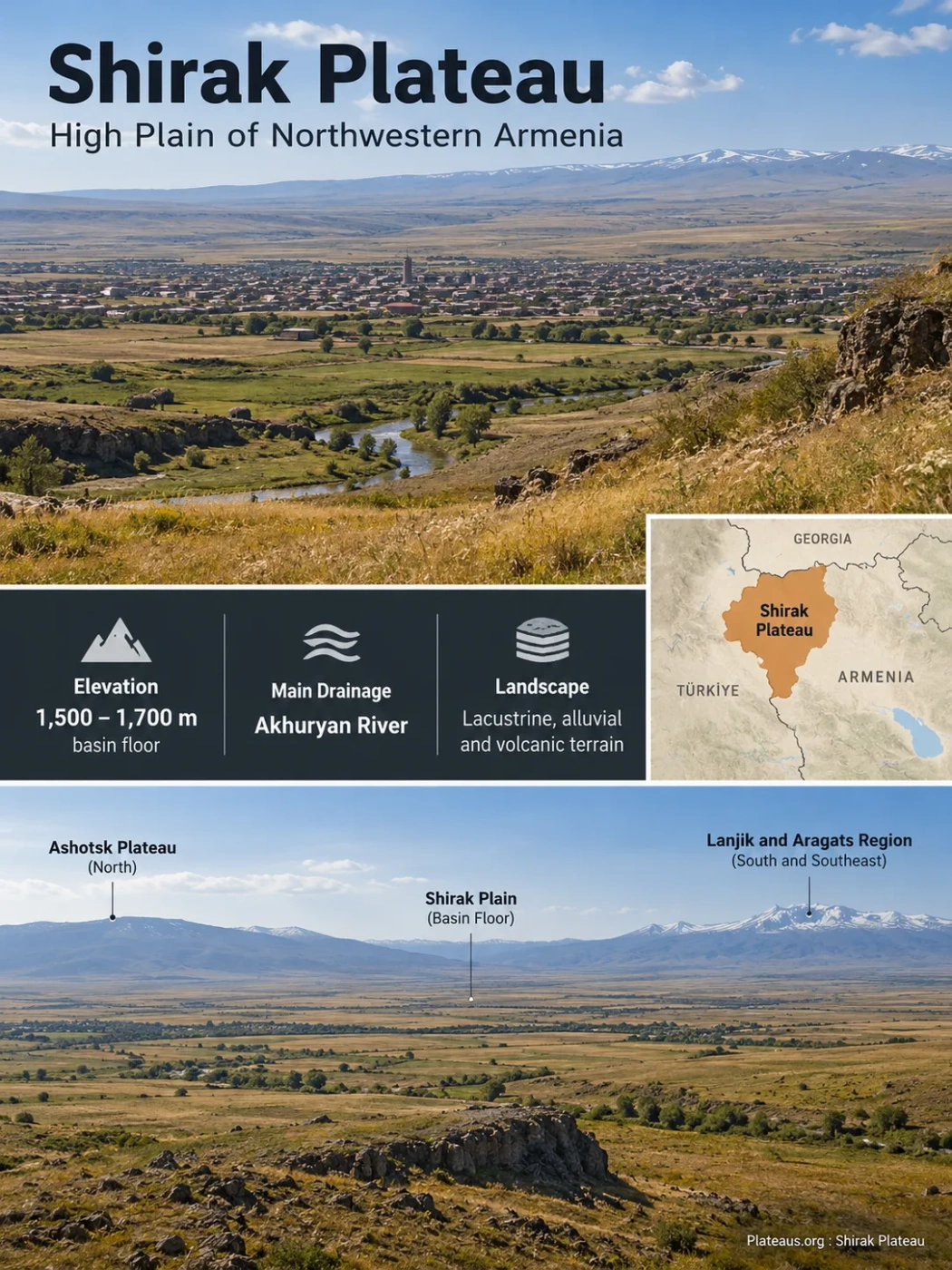
Northwestern Armenia · Intermontane High Plain
The Shirak Plateau is the broad high plain around Gyumri in northwestern Armenia, where a sediment-filled mountain basin, repeated lava flows, tectonic deformation, and river incision have produced an unusually open landscape within the Lesser Caucasus. Its surface commonly lies around 1,500–1,700 m above sea level, while surrounding ridges rise toward roughly 2,000–2,500 m.
Main drainage: Akhuryan River
Lacustrine, alluvial and volcanic terrain
Why Shirak Is Called a Plateau, Plain and Basin
Several names are used for the same broad landscape, but they describe different parts of its geography. Regional descriptions commonly use Shirak Plateau or Shirak Plain for the open high surface across central and southern Shirak Province. Geological studies usually use Shirak Basin or Shirak Depression because the surface occupies an intermontane depression filled by volcanic material and sediment.
| Term | What It Describes | Why It Is Used |
|---|---|---|
| Shirak Plateau | The elevated regional landscape | Emphasizes its high position and broad, relatively low-relief surface. |
| Shirak Plain | The visibly flat or gently rolling surface | Useful when discussing farming, settlement and the open terrain around Gyumri. |
| Shirak Basin / Depression | The underlying intermontane geological structure | Used when describing subsidence, basin fill, faults, former lakes and geological history. |
Landform Note
The terms are related rather than interchangeable in every context. A high plain can form the visible floor of a geological basin, while the word plateau describes its broader elevated setting. This also makes a single precise area figure for the “Shirak Plateau” difficult to defend unless the boundary definition is stated.
A High Plain Between Higher Mountain Blocks
Shirak occupies northwestern Armenia within the western Lesser Caucasus. Gyumri lies on the broad basin surface, while higher terrain rises around it. The Shirak mountain belt forms part of the northern margin, mountainous terrain lies to the east, and volcanic uplands associated with Lanjik and the Aragats region occur toward the south and southeast.
The Akhuryan River crosses the basin from north to south before becoming part of the Armenia–Türkiye boundary farther downstream. North of the main Shirak plain, the landscape rises into the colder and generally higher Ashotsk Plateau.
Higher Ashotsk uplands and mountain terrain
Broad basin floor, Gyumri, cultivated high plain and Akhuryan drainage
Lanjik volcanic terrain and lava-bearing landscapes toward Aragats
This arrangement explains why Shirak can look almost level when viewed across the plain even though it belongs to a mountainous region. The basin floor is hundreds of metres lower than many surrounding ridges, yet the floor itself remains high above sea level.
How a Mountain Basin Became a Broad High Surface
The present landscape developed through several processes rather than one episode of plateau formation. The Shirak Basin evolved from the Late Pliocene into the early Middle Pleistocene while volcanism, lake sedimentation, river deposition and crustal deformation repeatedly altered the basin floor.
An Intermontane Depression Develops
Relative lowering within the mountain region created accommodation space for lakes, streams, sediment and later lava flows. Older volcanic and sedimentary rocks remained beneath the developing basin.
Lava Reaches the Northern Basin
Basaltic trachyandesitic lava entered northern Shirak from the Javakheti volcanic highlands. Volcanism also affected the basin from other directions during its longer geological history.
The Karakhach Depositional Phase
Fine sediment deposited in standing or slow-moving water was combined with alluvial material. These deposits preserve evidence of a landscape with very different drainage and water conditions from those seen today.
Lake and River Sedimentation Continues
The younger Ani and Arapi units record further cycles in which lacustrine clays and silts were followed by sands, gravels and other river-derived sediment. The main zone of deposition shifted as different parts of the basin rose or subsided.
Uplift and Incision Reshape the Surface
The basin became involved in the wider uplift of the Lesser Caucasus. Rivers began cutting into surfaces that had previously accumulated sediment, leaving an elevated basin floor rather than a low enclosed depression.
The result is an important geographic combination: Shirak is structurally a basin but topographically a high plain. Its relatively flat surface reflects long periods of basin filling, while its modern altitude reflects regional uplift.
Why the Surface Is So Flat
Mountain basins can lose much of their original relief when depressions are progressively filled. Shirak received material from lakes, rivers, slope runoff, volcanic eruptions and lava flows. Each episode reduced local irregularities or created new broad surfaces.
A depression develops between mountain blocks.
Fine sediment, sand, gravel and other material accumulate on the basin floor.
Lava and tuff locally cover older surfaces and fill relief.
The filled basin rises as part of the surrounding highland.
The Akhuryan and its tributaries cut into the raised plain.
Flatness therefore does not imply geological simplicity. A level cultivated field can overlie hundreds of metres of deposits produced by lakes, rivers and eruptions that occupied the basin at different times.
What Lies Beneath the Shirak Plain
Geological work in the central basin describes a thick Pliocene–Quaternary succession containing lacustrine deposits, volcanic tuffs and andesitic flows. The combined upper basin fill reaches as much as about 300 m in studied sections. Beneath it lies an older doleritic basalt flow reported at about 50 m thick.
In the western part of the basin, still deeper Miocene sedimentary sequences have been reported with thicknesses reaching about 1,000 m. These figures describe particular geological sectors and should not be treated as uniform thicknesses beneath every part of Shirak.
Soils, cultivation, recent alluvium and river deposits
Lake sediments, river deposits, volcanic tuff and andesitic flows; locally hundreds of metres thick
Pliocene doleritic basalt beneath the younger basin succession
Miocene sedimentary and volcanic units over still older rocks
The diagram shows stratigraphic relationships in simplified form and is not a scale cross-section.
Volcanism Shaped Shirak Without Building One Single Plateau Volcano
Shirak has a strong volcanic imprint, but describing the entire landform as the product of one volcano would hide much of its history. Volcanic material reached the basin from several surrounding volcanic areas and during different periods.
Late Pliocene lava entered parts of the basin from the Kars–Digor highland to the west. Younger basaltic trachyandesites spread into northern Shirak from the Javakheti highlands. To the south and southeast, the Lanjik volcanic plateau and Pliocene–Quaternary lava flows associated with the Aragats volcanic system form another part of the geological setting.
Lava therefore acted together with basin subsidence and sedimentation. Some flows occupied or blocked older low ground; others became buried by later lake and river deposits. The modern plain is the product of this repeated overlap rather than a single preserved lava sheet.
Faults Define the Basin Margins
The shape of Shirak is closely tied to tectonic structures. Geological mapping places the Shirak thrust zone along the northern basin edge, where the Shirak mountain range rises above the plain. The eastern margin is less sharply defined and is associated with the north-northeast-trending Karnut Fault. A Shirakavan thrust zone has been mapped along part of the southern boundary.
The Akhuryan Fault is another major structure in the area. It trends northeast through the wider basin region toward Gyumri. Additional mapped faults divide the basin and surrounding volcanic terrain into smaller structural blocks.
Tectonic Meaning
Faults matter here because they help explain why the basin formed, why different sectors rose or subsided relative to one another, and why volcanic and sedimentary units occur at different elevations. A fault-controlled landscape should not be read as a claim that every mapped structure has the same present-day activity or hazard.
The Akhuryan River Cuts Across an Older Basin Floor
The Akhuryan is the main drainage line through Shirak. It crosses the basin from north to south and has cut into the otherwise broad, low-relief surface by several tens of metres in places. This incision creates a clear difference between the open plain and the deeper river corridor.
The modern north–south drainage pattern is not the only configuration preserved in the geological record. Research on the Quaternary basin indicates that drainage from northern Shirak once ran more toward the east, in the direction of an older Pambak valley system. Uplift and deformation later reorganized the terrain, helping establish the north–south drainage seen today.
A recent geomorphological assessment describes one of the Akhuryan terrace levels as broadly coinciding with the Shirak Plain surface at an average elevation near 1,650 m. Higher remnants preserve traces of older river positions, while younger incision records the progressive cutting of the modern valley.
Dark Steppe Soils Cover Much of the Agricultural Surface
The broad plain provides more continuous land for cultivation than the surrounding mountain slopes. Regional soil assessments identify mountain-steppe black soils across much of the Shirak and Ashotsk plateau area, mainly within an elevation belt of about 1,500–2,200 m and locally higher.
These soils can contain a dark, humus-rich upper horizon. Reported regional values place humus content from roughly 4–5% to as much as 10–11% in some black-soil profiles, with the dark soil layer commonly around 50–65 cm thick. Local soil depth and quality still vary with parent material, drainage, erosion, slope and land use.
The combination of relatively level terrain and fertile steppe soils supports grain cultivation, fodder production and grazing. Elevation imposes a different limitation: winters are long, the frost-free growing period is restricted, and crop production depends strongly on seasonal water availability.
Irrigation Changes What the High Plain Can Support
The Akhuryan is therefore important for more than landscape erosion. Water diverted from the river has long supported agriculture on the plain. The Shirak Canal, constructed in 1922–1925, expanded irrigation from the Akhuryan and altered the practical relationship between the river corridor and cultivated land away from the channel.
Water remains a limiting resource because a fertile soil does not guarantee reliable crop moisture. Snowmelt, spring runoff, reservoirs, canals and irrigation infrastructure all influence how intensively the plain can be cultivated.
Shirak and Ashotsk Are Neighboring but Different Uplands
Shirak Province contains two high, open landscapes that are easily confused in broad regional descriptions. The Shirak Plateau occupies the central and southern part of the province, while the Ashotsk Plateau lies farther north.
Shirak Plateau
- Broad intermontane plain and basin surface around Gyumri
- Common basin-floor elevations around 1,500–1,700 m
- Extensive cultivated surfaces
- Strong record of lacustrine, alluvial and volcanic basin fill
- Akhuryan River cuts through the plain
Ashotsk Plateau
- Higher upland north of the main Shirak plain
- More closely associated with the Javakheti–Ashotsk volcanic highlands
- Colder upland conditions and extensive grassland terrain
- Forms part of the headwater landscape feeding the upper Akhuryan system
- Should not be treated as the northern half of one uniformly flat Shirak surface
The distinction also helps explain why province-wide climate or elevation extremes cannot automatically be assigned to the Shirak Plateau itself. Measurements from the higher northern uplands may describe Ashotsk rather than the central Shirak basin.
The Pleistocene Landscape Preserves Early Human Evidence
Shirak’s geological record also matters to archaeology. Paleolithic sites in the province occur in close association with the Shirak Depression, the Akhuryan gorge, the Ashotsk Plateau and the northwestern slopes of Aragats. Their locations reflect the same Plio-Pleistocene processes that shaped the modern terrain: volcanism, lake formation, river deposition and changing relief.
The region provided useful stone raw materials including dacite, obsidian and flint. Archaeological finds occur on terraces, low hills and surfaces linked to former river and lake environments. Some Lower Paleolithic material belongs to the wider Acheulian record of the Armenian Highlands.
This evidence makes the basin fill more than a buried geological sequence. Sediment, volcanic ash, old soils and former water surfaces can preserve information about both changing environments and human occupation, allowing the landscape history to be reconstructed across much of the Pleistocene.
Akhuryan–Shirak Is Now Being Studied as a Wider Geoheritage Region
A 2026 study assessed a proposed Akhuryan–Shirak Volcanic Geopark covering about 1,700 km² of northwestern Armenia. The study area combines volcanic landforms, the Akhuryan canyon, Lake Arpi, mineral springs and cultural sites within a broader geoheritage landscape.
The 1,700 km² Figure Is Not the Area of the Shirak Plateau
The proposed geopark covers a wider territory within Shirak Province and includes landscapes beyond the central Shirak Plateau. Its published area should therefore not be used as a plateau-area measurement.
The research evaluates the region’s potential for UNESCO Global Geopark designation. It does not mean that the Shirak Plateau or the proposed Akhuryan–Shirak area already holds UNESCO Global Geopark status. The value of the proposal for physical geography is that it treats the volcanic uplands, basin floor, river incision and surrounding mountain terrain as parts of one connected landscape system.