INTERACTIVE CONTEXT MAP
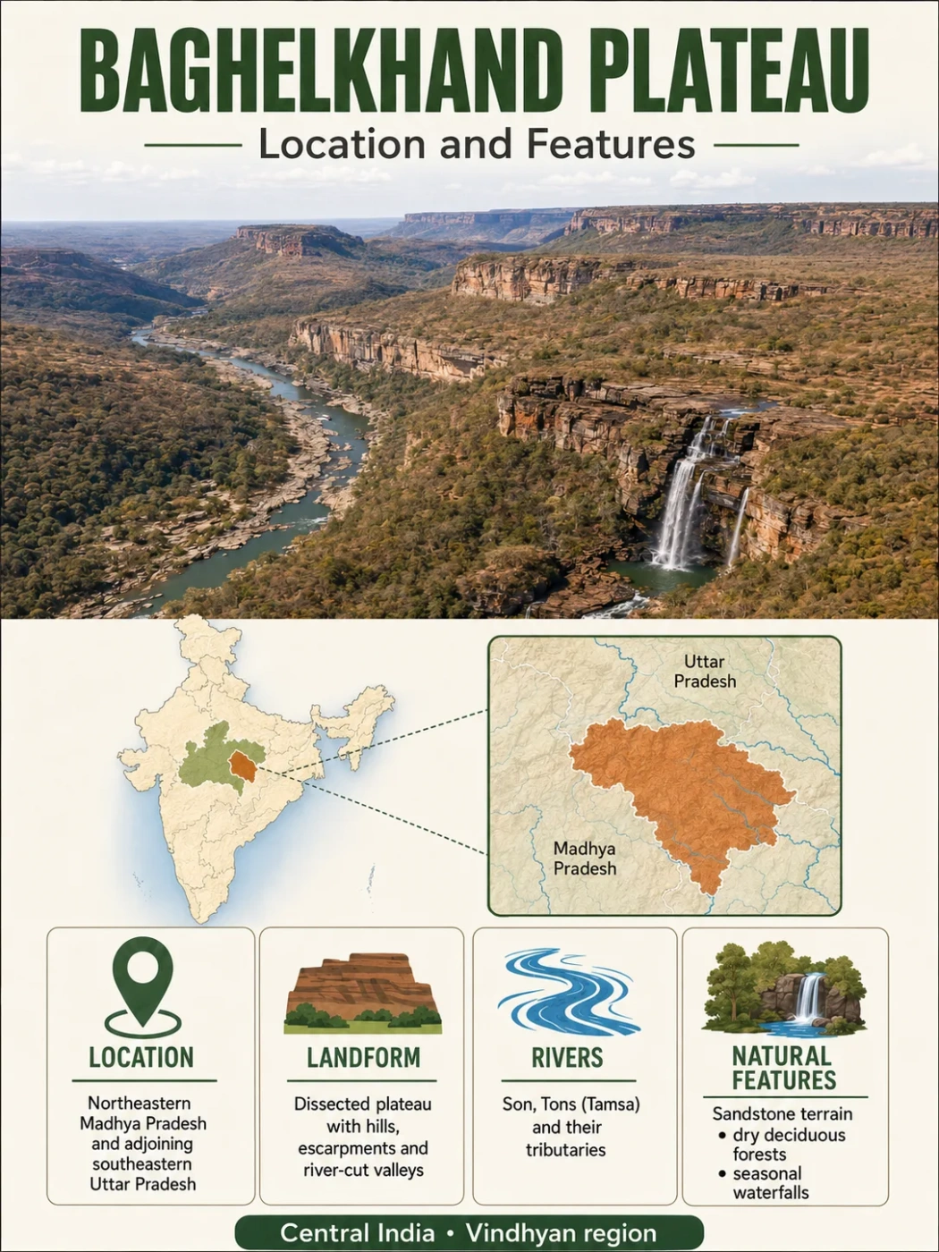
Where is Baghelkhand Plateau?
The selected plateau and nearby mapped locations are shown. Open the full world atlas to explore every region.
Central India · Dissected Plateau Region
The Baghelkhand Plateau is a broken upland region of central India, centered on northeastern Madhya Pradesh and extending into the adjoining highlands of northern Chhattisgarh. Its landscape is defined less by a single flat surface than by river-cut plateaus, scarps, ridges, sedimentary basins and a major divide between the Son and Mahanadi drainage systems.
Dissected uplands
Son–Mahanadi divide
Mixed rock terrain
Where the Baghelkhand Plateau Lies
Baghelkhand occupies a transition zone in central-eastern India. Its main physiographic core lies in northeastern Madhya Pradesh, while related uplands continue east and southeast into northern Chhattisgarh. Older physiographic classifications commonly described Baghelkhand through the former districts of Sidhi, Shahdol and Surguja, but those historical administrative units have since been divided and reorganized.
This matters because the plateau is a physical region rather than an administrative region. A modern district map cannot be used as an exact outline of the landform. Current official descriptions still use the name in a physical sense: the Manendragarh-Chirmiri-Bharatpur district of northern Chhattisgarh, for example, identifies its terrain as part of the Eastern Baghelkhand Plateau.
Boundary Note
The Baghelkhand Plateau does not have one universally surveyed outer boundary. Different physiographic schemes place its margins somewhat differently, especially where it meets the Vindhyan uplands, Maikal highlands, Chhattisgarh uplands and Chhota Nagpur terrain. Any mapped outline should therefore be read as an approximate physical boundary rather than a political border.
The plateau can be placed within a broader set of surrounding landforms:
Son valley and Kaimur–Vindhyan scarplands
Dissected uplands, basins, ridges and river valleys
Maikal highlands, northern Chhattisgarh uplands and the transition toward Chhota Nagpur
A Plateau Made of Broken Surfaces Rather Than One Flat Tableland
The word plateau can give the wrong impression here. Baghelkhand is not a broad, uninterrupted tabletop. Long periods of erosion and river incision have separated the higher ground into uneven surfaces, producing a landscape that can look hilly or rugged at ground level.
Broad upland remnants survive between drainage lines, but streams have cut into them and created valleys, scarps, rolling divides and isolated higher blocks. Lower basin-like areas interrupt the plateau surface as well. The result is a strongly varied relief pattern rather than one recognizable plateau rim enclosing a level interior.
Upland Surface
Plateau Remnants
Broad areas of higher ground preserve parts of older erosional surfaces, though few remain uniformly level over long distances.
River Erosion
Dissected Valleys
The Son and its tributaries have cut into the uplands, separating plateau blocks and increasing local relief.
Resistant Rock
Scarps and Ridges
Harder rock layers and crystalline bedrock can stand above surrounding surfaces as steep margins, ridges and resistant hills.
Lower Terrain
Basins and Valley Floors
Sedimentary basins and river corridors create lower surfaces between the surrounding uplands.
Why the Western and Eastern Landscapes Differ
One of Baghelkhand’s most useful geographic clues is that its bedrock changes across the region. Simplified physiographic descriptions often characterize the western side as dominated by limestone and sandstone and the eastern side as having more granitic or crystalline terrain. The real geology is more varied, particularly toward northern Chhattisgarh, where Gondwana sedimentary rocks form an important part of the landscape.
Along the western approach to Baghelkhand, the broader Vindhyan region contains thick sedimentary sequences of sandstone, shale and limestone. Resistant sandstone beds can maintain scarps and higher benches, while weaker shale and some limestone units weather and erode differently.
Farther east and southeast, older crystalline rocks become more important in parts of the uplands. These rocks tend to produce more irregular terrain, weathered slopes, residual hills and exposed bedrock rather than the strongly layered forms associated with sedimentary strata.
There is also a third setting that prevents Baghelkhand from being described simply as a sandstone-to-granite transition: Gondwana basins. Sedimentary basins around the eastern plateau country include coal-bearing formations and lower structural terrain within the larger upland region. The Sohagpur and Singrauli areas are notable examples of this broader Gondwana geological setting.
| Rock Setting | Typical Landscape Expression | Where It Matters |
|---|---|---|
| Sandstone | Resistant rims, scarps, stepped slopes and locally flatter upland surfaces | Western and northwestern sedimentary margins |
| Shale and limestone | More variable slopes and lower surfaces where less-resistant beds are exposed | Parts of the Vindhyan sedimentary sequence |
| Granite and other crystalline rocks | Irregular ridges, rounded weathered hills and bedrock-controlled uplands | Parts of the eastern and southeastern plateau country |
| Gondwana sedimentary rocks | Basin-like terrain, broad valleys and coal-bearing sedimentary sequences | Several eastern and southeastern sectors |
Geology Note
Descriptions such as “sandstone in the west and granite in the east” are useful for orientation, but they are regional generalizations. Baghelkhand contains several geological settings, and Gondwana sedimentary basins are especially important in the eastern plateau country.
The Son River Organizes Much of the Plateau’s Drainage
The Son River system provides one of the clearest ways to understand Baghelkhand on a physical map. The upper Son and its tributaries drain large parts of the plateau, and their valleys help separate upland blocks that would otherwise appear as a more continuous elevated surface.
In the traditional physiographic description of Baghelkhand, the upper Son is closely associated with the Shahdol and Sidhi sectors. Sidhi lies along the upper Son valley beneath the Kaimur margin, while streams from the surrounding uplands converge toward the main river system.
The Gopad, Rihand, Banas and other tributaries drain different parts of this eastern central Indian upland. The Rihand flows northward into the Son system, while the Gopad drains terrain farther west. In northern Chhattisgarh, the Banas also belongs to the Son basin.
Rain and runoff enter short streams across dissected higher ground.
Streams including the Gopad, Rihand and Banas collect drainage from different sectors.
Much of the northern drainage is concentrated into the Son system.
The Son ultimately carries this drainage northeastward into the Ganga river system.
The Son–Mahanadi Divide Is One of Baghelkhand’s Defining Features
Baghelkhand is especially important in regional drainage geography because its higher central and southern ground separates rivers flowing toward two major basins.
Water falling on one side of the divide enters tributaries of the Son and ultimately reaches the Ganga system. Water falling on the other side can enter tributaries of the Mahanadi. The boundary between them is not a straight ridge. It winds through an irregular landscape of high ground, scarps and plateau surfaces.
Northward Drainage
- Feeds the Son basin
- Includes the Rihand, Gopad and Banas systems in different sectors
- Ultimately joins the Ganga drainage network
Southward and Southeastward Drainage
- Feeds tributaries associated with the Mahanadi basin
- Includes the Hasdeo system in the eastern plateau country
- Flows toward the east-central Indian drainage network
The divide can be seen particularly well in northern Chhattisgarh. In the Manendragarh-Chirmiri-Bharatpur area, the Banas belongs to the Son basin while the Hasdeo belongs to the Mahanadi system. Two rivers beginning within the same broader upland region therefore travel toward different major drainage networks.
Watershed Feature
The Baghelkhand Plateau does not have one overall drainage direction. Its higher ground functions partly as an inter-basin watershed, sending runoff toward the Son–Ganga system on one side and the Mahanadi system on the other.
Elevation Is Better Understood as Relief Than as One Plateau Height
Published descriptions sometimes assign Baghelkhand a very broad elevation range. Such figures need care because different sources include different combinations of river valleys, main plateau surfaces, high scarps and adjoining upland margins.
A single average elevation is therefore less informative than the internal relief pattern. Lower corridors occur along the main rivers and basin floors. Above them lie rolling or dissected plateau surfaces, followed locally by resistant ridges and higher margins toward the Maikal and adjoining highland country.
Son and tributary valleys occupy some of the lowest terrain within the regional plateau system.
Much of the landscape consists of broken plateau surfaces separated by drainage lines.
Harder rock units create locally steeper and higher terrain.
Relief rises toward parts of the southern and eastern transition zones, including the Maikal–Amarkantak side of the region.
This relief also explains why Baghelkhand can appear very different depending on where it is viewed. A broad interfluve may resemble gently rolling plateau country, while a nearby river-cut sector can contain steep slopes, narrow valleys and strongly broken hills.
Baghelkhand Plateau and Historical Baghelkhand Are Not the Same Boundary
The name Baghelkhand has geographical, historical and cultural meanings. The historical region has included a wider area associated with Rewa and neighboring territories. The physiographic term Baghelkhand Plateau is narrower and refers to a landform region defined through terrain, rock structure and drainage.
This distinction becomes especially important around Rewa and the Vindhyan scarplands. A location may belong to historical Baghelkhand without belonging to the Baghelkhand Plateau under a particular physiographic classification.
Baghelkhand
- A historical and cultural regional name
- Can include territories extending beyond the plateau landform
- Its boundaries have changed through administrative history
Baghelkhand Plateau
- A physical-geography unit
- Defined by relief, drainage and geological setting
- Has approximate transitional margins rather than political borders
Why Rewa–Panna Needs Separate Treatment
The most common map confusion concerns the Rewa or Rewa–Panna Plateau. Rewa has a strong historical connection with Baghelkhand, but several Indian physiographic schemes treat the Rewa Plateau and the Baghelkhand Plateau as separate physical divisions.
Rewa–Panna belongs more closely to the Vindhyan scarp and sandstone plateau country to the west and northwest, while Baghelkhand extends farther southeast into the Son-drained and Maikal-adjacent uplands. The transition between them is geographic rather than a sharp administrative line.
Common Map Mix-Up
A historical map labeled “Baghelkhand” should not automatically be used as a map of the Baghelkhand Plateau. Historical territory, present-day districts and physiographic divisions describe three different kinds of boundaries.
How Rock, Relief and Rivers Produce the Present Landscape
The modern shape of Baghelkhand can be understood as the interaction of three controls rather than as the product of one event. Bedrock establishes zones of different resistance, regional relief gives streams the gradient to flow across the uplands, and continued river erosion cuts those surfaces into smaller blocks.
Different Rock Units
Sandstone, limestone, shale, crystalline rocks and Gondwana sediments weather and erode at different rates.
Uneven Relief Develops
More resistant units tend to preserve higher surfaces, ridges or scarps while weaker zones are lowered more readily.
Drainage Cuts the Uplands
The Son and numerous tributaries incise the raised terrain and separate older surfaces into dissected blocks.
Basins and Valleys Interrupt the Plateau
Structural lows, sedimentary basins and river corridors create broad lower areas between the remaining uplands.
What the Terrain Means for Soils, Forest and Land Use
Baghelkhand’s environmental pattern follows its relief closely. Ridge tops and steep slopes tend to have thinner or more strongly eroded soil cover, while gentler surfaces and valley floors can accumulate deeper weathered material or river sediment. The result is a patchwork rather than one uniform plateau soil.
Seasonal monsoon rainfall produces strong contrasts between wet-season runoff and lower dry-season flow in many smaller streams. Where slopes are steep, water moves downslope quickly and erosion can be more active. Lower-gradient valley floors retain more sediment and generally provide more favorable terrain for cultivation.
Forested land remains extensive in parts of the eastern and southern uplands, particularly where rugged relief makes intensive cultivation and settlement more difficult. Sal and mixed deciduous forest are common across parts of the northern Chhattisgarh plateau country, while lower valleys and gentler uplands support a greater concentration of agriculture and settlements.
Gondwana basins add another physical influence on land use. Their coal-bearing sedimentary rocks have supported major mining areas, including parts of the broader Singrauli and Sohagpur coal regions. Limestone resources are more closely associated with the sedimentary terrain toward the Vindhyan side. These mineral patterns follow the underlying geology rather than the plateau boundary itself.