Central Turkey · Dissected Upland
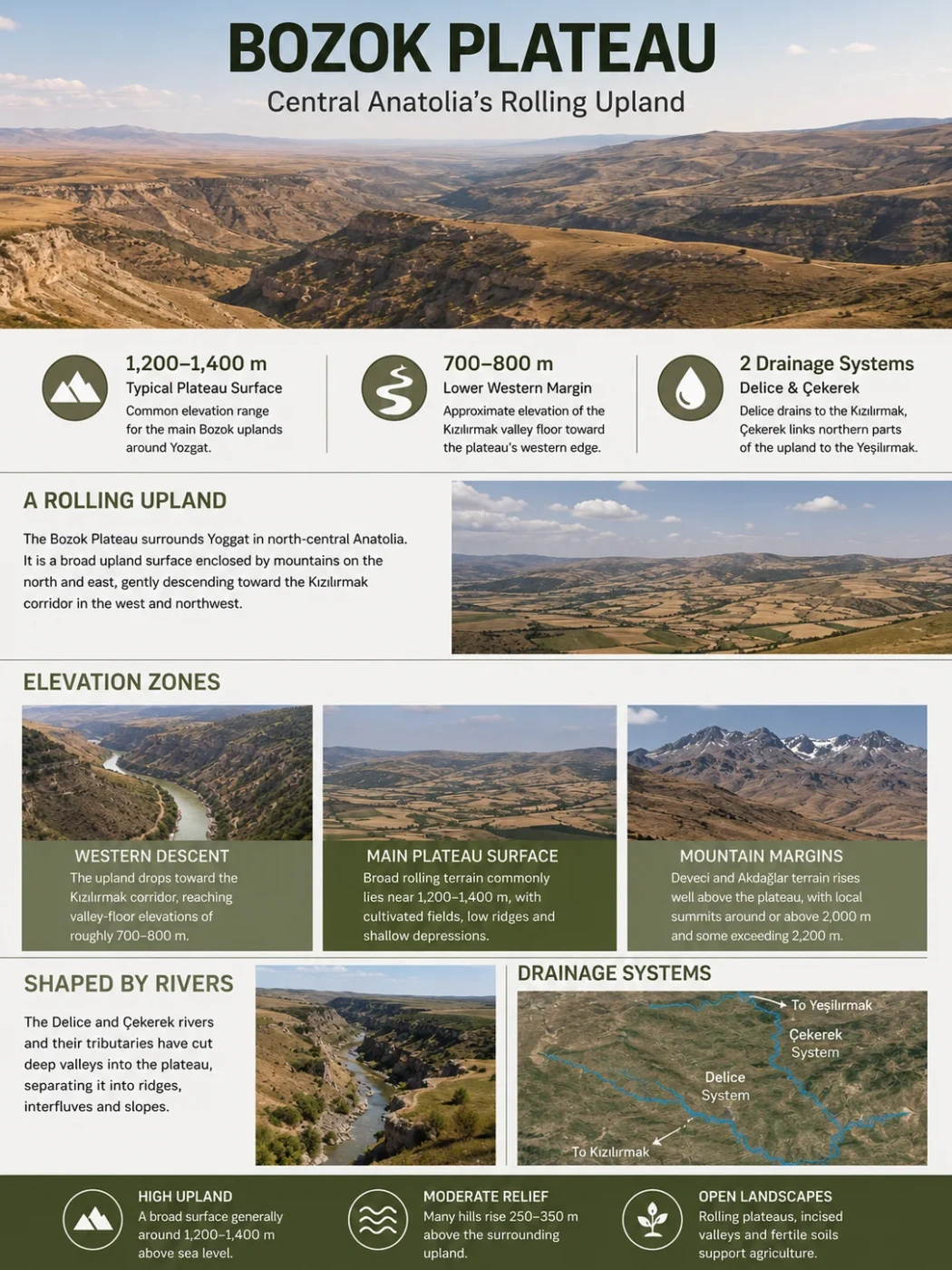
The Bozok Plateau is a broad, rolling upland centered on Yozgat in north-central Anatolia. Much of its main surface lies around 1,200–1,400 meters above sea level, but the landscape is far from level: rivers have cut valleys into the plateau, low hills rise above the general surface, and the terrain descends markedly toward the Kızılırmak corridor in the west and northwest.
Typical Plateau Surface
A commonly cited elevation range for the main Bozok uplands around Yozgat.
Lower Western Margin
Approximate elevation of the Kızılırmak valley floor where the plateau descends toward its western edge.
Regional Watersheds
The Delice system drains toward the Kızılırmak, while the Çekerek system connects northern parts of the upland with the Yeşilırmak.
A Rolling Upland Inside the Kızılırmak Arc
The Bozok Plateau occupies much of the upland country around Yozgat, in the northeastern part of Turkey’s Central Anatolia Region. Geographic descriptions commonly place it within the broad arc formed by the Kızılırmak and treat it as one of the main plateau landscapes of this part of the Anatolian interior.
The plateau does not have a sharply surveyed boundary comparable with a province or district. It grades into river valleys, mountain belts, smaller plains and neighboring uplands. Yozgat therefore provides the clearest geographic reference point, but the physical landscape extends beyond the city itself.
Mountain terrain becomes more prominent around the margins. The Deveci Mountains rise along the northern side toward Tokat, while the Akdağlar form a much higher eastern and southeastern margin toward Sivas and Kayseri. These ranges make the Bozok surface feel enclosed in places even though its central area consists mainly of open uplands rather than mountain country.
Name Note
Turkish geographic sources often use Bozok Platosu and Bozok Yaylası for this broad regional upland. In this context, yayla refers to the larger highland landscape rather than necessarily to one seasonal mountain pasture.
The Plateau Is a Surface, Not a Single Elevation
Bozok is commonly described as standing about 1,200–1,400 meters above sea level, but that range represents the general plateau surface rather than every point within it. Local hills, incised valleys and surrounding mountain blocks create much more vertical variation.
The upland drops toward the Kızılırmak corridor, reaching valley-floor elevations of roughly 700–800 m.
Broad rolling terrain commonly lies near 1,200–1,400 m, with cultivated fields, low ridges and shallow depressions.
Deveci and Akdağlar terrain rises well above the plateau, with local summits around or above 2,000 m and some exceeding 2,200 m.
Numerous hills stand only moderately above the surrounding upland. Relative heights of roughly 250–350 meters are reported for many of these features. They add relief without changing the overall impression of a broad plateau surface.
This combination of a high regional base level and moderate local relief explains why Bozok can look open and gently rolling from a distance while still containing steep slopes and deeply cut valleys at closer range.
Rivers Have Cut the Plateau Into Separate Upland Surfaces
River incision is one of the most useful ways to understand the present shape of Bozok. The plateau is crossed by the Delice and Çekerek river systems and by numerous smaller tributaries. Over time, these channels have cut below the older upland surface and divided it into ridges, rolling interfluves and valley-side slopes.
Upland tributaries → Delice River → Kızılırmak
Upland tributaries → Çekerek River → Yeşilırmak
The drainage pattern means that Bozok is not a single surface tilted toward one outlet. Different parts of the upland feed two major river systems. The Delice carries water toward the Kızılırmak, while the Çekerek belongs to the Yeşilırmak basin farther north.
Where valleys widen or depressions collect sediment, narrow alluvial plains interrupt the higher terrain. The Yerköy and Boğazlıyan areas are examples of lower, flatter surfaces associated with river and stream deposition. These plains are embedded within the wider plateau landscape rather than replacing it.
Badland-Like Erosion on Some Slopes
Not every eroded slope on Bozok has the same appearance. In places where runoff cuts easily eroded material, closely spaced gullies can separate narrow, sharp ridges. Turkish geographic descriptions refer to some of these surfaces as kırgıbayırı, or badland terrain.
These rough surfaces are local features rather than the dominant form of the entire plateau. Their presence nevertheless shows how strongly seasonal runoff can reshape exposed slopes within an otherwise rolling upland.
Bozok Is Not One Rock Surface
The plateau’s varied appearance partly reflects its varied geology. The Yozgat region contains sedimentary, volcanic, intrusive and ophiolitic rocks rather than one continuous rock layer. Erosion therefore works at different rates from one sector to another.
| Area | Common Geological Character | Landscape Expression |
|---|---|---|
| Northern and northeastern sectors | Limestone together with ophiolitic and serpentinite-bearing units in parts of the Çekerek–Kadışehri area | More irregular relief and locally rougher upland terrain |
| Central Yozgat belt | Mixed sedimentary rocks with granite, granodiorite and related intrusive rocks exposed in parts of the region | Rolling uplands interrupted by resistant hills and rocky surfaces |
| Western areas around Yerköy and Şefaatli | Gypsum-bearing sedimentary formations occur locally | Softer eroded terrain and soils that can be affected by salts |
| Southern and southeastern sectors | Volcanic materials and lava-covered terrain occur across parts of the upland | Streams can become entrenched, producing deeper valleys through the volcanic surface |
| River valleys and depressions | Younger alluvial deposits | Flatter valley floors and small plains within the higher plateau |
The southern volcanic terrain is particularly important to the plateau’s physical character. Rivers cutting into these harder volcanic surfaces can occupy narrow, deeply incised valleys. In the northeast, widespread limestone contributes to a different, more uneven landscape. The result is a plateau whose appearance changes noticeably across relatively short distances.
Yozgat’s Climate Shows the Effect of a High Continental Interior
The main Bozok uplands lie far from the moderating influence of the sea and stand high enough for winters to be distinctly cold. Long-term observations from Yozgat provide a useful climatic reference for the central part of the plateau, although conditions vary with elevation, exposure and position within the wider upland.
The temperature cycle is strongly continental. Mean monthly temperature is below freezing in January and February, rises rapidly through spring, and reaches about 20°C in midsummer. Rainfall follows a different pattern: winter and spring are much wetter than July and August.
| Month | Mean Temperature (°C) | Average Monthly Precipitation (mm) |
|---|---|---|
| January | -1.6 | 67.2 |
| February | -0.6 | 58.8 |
| March | 3.1 | 68.9 |
| April | 8.5 | 58.4 |
| May | 13.1 | 66.3 |
| June | 16.8 | 45.3 |
| July | 19.6 | 13.0 |
| August | 19.9 | 11.2 |
| September | 15.9 | 18.8 |
| October | 10.8 | 32.8 |
| November | 5.2 | 53.6 |
| December | 0.7 | 74.8 |
Climate Data Note
These values describe the Yozgat observation record, not a calculated average for every part of the Bozok Plateau. Higher mountain margins and lower river corridors can differ noticeably from the central upland.
The sharp summer decline in precipitation is especially important for the landscape. July and August are the driest months in the long-term Yozgat record, while winter and spring receive much more moisture. Combined with open terrain and continental temperatures, this seasonal pattern favors steppe vegetation and dry farming across large parts of the plateau.
Steppe Fields Are Broken by Woodland Islands
Open steppe and cultivated land dominate much of Bozok, but the plateau should not be pictured as completely treeless. Woodland survives where elevation, moisture and local terrain provide more favorable conditions, particularly around higher margins and protected uplands.
Yozgat Çamlığı is one of the clearest examples near the central plateau. Natural black pine woodland occurs roughly between 1,400 and 1,600 meters there, together with oak and juniper communities. Its presence creates a marked contrast with the surrounding steppe and agricultural surfaces.
Woodland becomes more extensive toward parts of the higher eastern terrain, while broad central and western surfaces are generally more open. The shift is gradual rather than a sharp vegetation boundary.
Relief Helps Explain the Agricultural Pattern
The same landform pattern that shapes drainage also influences land use. Broad plateau surfaces with moderate slopes provide large areas suitable for cultivation, making the Bozok uplands one of the principal agricultural landscapes around Yozgat.
Large, gently rolling areas allow extensive fields. Wheat and barley fit the continental climate and the widespread reliance on rain-fed agriculture.
Alluvial sediment and easier access to water create smaller belts of flatter and often more productive agricultural land.
Deeply incised slopes, badland surfaces and rougher mountain margins interrupt continuous cultivation and are more likely to remain as grazing land or natural vegetation.
The agricultural landscape is therefore not simply a consequence of climate. It also follows the geometry of the plateau: cultivation spreads most continuously across broad interfluves and gentler surfaces, while valleys, eroded slopes and mountain margins break that pattern.
Bozok Plateau and the Central Anatolian Plateau Are Different Scales
Bozok belongs to the wider high interior of Central Anatolia, but the two names do not describe the same geographic scale. The Central Anatolian Plateau includes a much larger collection of basins, plains, volcanic uplands and plateau surfaces extending across central Turkey.
Bozok Plateau
- Centered mainly on the Yozgat uplands.
- Commonly described around 1,200–1,400 m.
- Strongly dissected by the Delice, Çekerek and their tributaries.
- Characterized by rolling agricultural uplands, local badlands, volcanic sectors and limestone terrain.
- Drains toward both the Kızılırmak and Yeşilırmak systems.
Central Anatolian Plateau
- Covers a much broader part of Turkey’s interior.
- Includes major plains, enclosed basins and volcanic landscapes beyond Yozgat.
- Contains a wider elevation range and several distinct drainage settings.
- Includes dry steppe basins as well as dissected and volcanic uplands.
- Bozok represents one regional expression of this larger interior highland system.