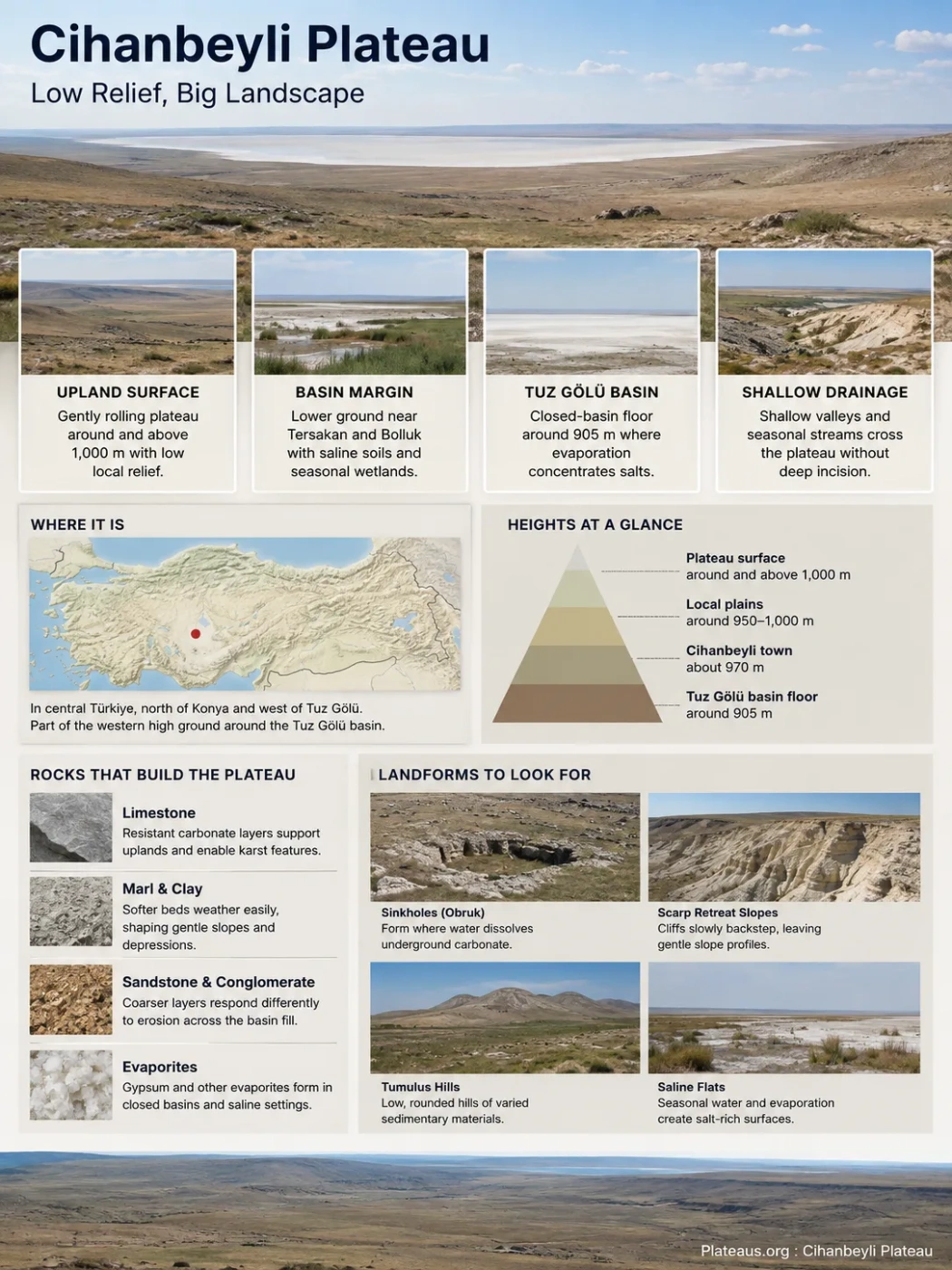
The Cihanbeyli Plateau is a broad, semi-arid upland in central Türkiye where gently rolling steppe descends toward the saline depressions of the Tuz Gölü basin. Its geography is defined less by dramatic relief than by the transition between roughly 1,000-metre plateau surfaces, shallow drainage, dry farmland, salt-affected lowlands and several unusual erosion and mineral-deposition landforms.
A Low-Relief Plateau Beside Tuz Gölü
Cihanbeyli lies north of Konya and west of Tuz Gölü, within the dry interior of Central Anatolia. The plateau forms part of the western high ground surrounding the Tuz Gölü depression, while the Haymana Plateau approaches from the north and the Obruk and Altınekin plateau country lies farther south.
The landscape does not have a single sharp escarpment marking where the plateau begins. Around Cihanbeyli, broad upland surfaces grade into plains, shallow valleys and lower basin margins. Official geographic descriptions place many of the local plains around 950–1,000 metres above sea level, while plateau sections generally rise above 1,000 metres. Cihanbeyli town itself stands at about 970 metres.
Geography Note
The Cihanbeyli Plateau and Cihanbeyli administrative district should not be treated as identical areas. The district has fixed administrative boundaries; the plateau is a physical landform whose edges merge gradually with adjoining plains, basins and uplands.
Gently rolling steppe surfaces, dry farmland and locally incised valleys.
Broad terrain generally around and above 1,000 m with relatively low local relief.
Lower ground around Tersakan and Bolluk with salt-affected soils and seasonal wetland surfaces.
A closed-basin lowland around 905 m where evaporation concentrates salts.
Why It Looks Almost Flat Without Being a Plain
The Cihanbeyli Plateau is a useful example of a plateau with low surface relief. Much of the terrain consists of long, gentle slopes rather than cliffs, deep canyons or high mountain blocks. From ground level, some sections can resemble an open plain because elevation changes occur gradually over long distances.
What distinguishes the landscape is its regional position above adjacent closed-basin floors. Tuz Gölü lies lower than much of the plateau to its west, while smaller depressions occupy parts of the transition zone. Shallow valleys and seasonal drainage lines also cut the upland surface without producing the deeply dissected terrain found on more rugged plateaus.
This makes elevation alone a poor way to read the landform. The important pattern is the relationship between a broad elevated surface and the lower depressions into which parts of that surface drain.
Sedimentary Rocks Shape the Gentle Surface
Much of the Cihanbeyli landscape is developed on Cenozoic basin deposits rather than a single massive bedrock type. Geological work in the Tuz Gölü region describes the Cihanbeyli Formation as including lacustrine limestone, marl and clay-rich units, with conglomerate and sandstone also present in parts of the sequence.
These rocks record periods when lakes, shallow basins and sedimentary environments occupied parts of Central Anatolia. Later uplift, faulting, weathering and erosion exposed and reshaped those deposits.
More resistant carbonate layers can support firmer upland surfaces and locally participate in karst development.
Softer material is more easily weathered and eroded, helping produce gentle slopes and broad depressions.
Coarser sedimentary layers occur within parts of the regional basin fill and can respond differently to erosion.
The result is not a perfectly horizontal rock platform. Cihanbeyli is better understood as an elevated sedimentary landscape whose present surface reflects both the history of the Tuz Gölü basin and later erosion.
The Plateau Descends Into a Closed Salt-Basin System
The eastern side of the Cihanbeyli Plateau is closely tied to endorheic drainage. Water entering an endorheic basin has no river outlet to the sea. It collects in internal depressions, infiltrates into the ground or is lost mainly through evaporation.
This drainage pattern explains why salt lakes and salt flats occur beside the plateau. Water carries dissolved minerals toward low areas. Repeated evaporation removes water while leaving much of the dissolved material behind.
Rain and snowmelt move through shallow channels and across gentle slopes.
Water collects in lower terrain because there is no continuous outlet to the sea.
Hot, dry summers remove much of the shallow surface water.
Salts remain in lake sediments, marshes and exposed basin-floor crusts.
Tuz Gölü, Tersakan and Bolluk
Tuz Gölü is the dominant depression east of Cihanbeyli, but it is not the only saline water body associated with this landscape. Tersakan Lake and Bolluk Lake occupy smaller depressions within the same broader dry-basin setting.
| Feature | Setting | Geographic Expression |
|---|---|---|
| Tuz Gölü | East of the plateau | Large terminal saline basin with shallow water, exposed lake floor and extensive salt-flat terrain. |
| Tersakan Lake | Cihanbeyli basin margin | Smaller salt-lake and salt-pan environment linked to saline soils and wetland habitats. |
| Bolluk Lake | Southeast of Cihanbeyli | Saline depression distinguished by mineral springs, carbonate deposits and travertine cones. |
Bolluk, Tersakan and Tuz Gölü are therefore better read as parts of a connected continental evaporative landscape than as isolated lakes with unrelated origins.
Steppe Changes Into Salt-Tolerant Vegetation Toward the Basin
The Cihanbeyli Plateau lies within one of the driest parts of Central Anatolia. A recent bioclimatic analysis using Cihanbeyli station data reported mean annual precipitation of about 326.5 mm and identified a dry period extending from May into early October. Winters are cold, while summers combine low rainfall with strong evaporation.
These conditions favor open steppe vegetation rather than continuous forest. Studies of the wider Cihanbeyli region place its dry grassland and shrub communities within the Irano-Turanian phytogeographic setting, with xerophytic vegetation adapted to calcareous soils, summer drought and winter cold.
The vegetation changes as elevation falls toward saline depressions. Better-drained uplands support dry steppe and large areas of cultivated land. Near Tersakan, Bolluk and the Tuz Gölü margin, increasing soil salinity favors halophytic communities adapted to salt-affected ground.
Xerophytic steppe on better-drained upland soils.
Broad cereal fields occupying gentle plateau surfaces.
Salt-tolerant vegetation increases where groundwater and salts approach the surface.
Vegetation becomes sparse on strongly saline and seasonally exposed basin floors.
This ecological gradient is one of the clearest ways to read the plateau in the field. The landscape does not shift abruptly from “steppe” to “salt lake”; it passes through cultivated surfaces, dry grasslands, saline soils, seasonal wetlands and exposed mineral-rich sediments.
Bolluk Lake Contains an Unusual Travertine Landscape
The generally subdued relief around Cihanbeyli has a notable exception near Bolluk Lake. Mineral-rich groundwater has produced travertine cones and related carbonate landforms around parts of the lake margin.
A detailed 2026 geomorphological survey identified 64 travertine cones in the Bolluk area, concentrated mainly north and east of the lake. The same landscape includes tufa deposits, dolines, a travertine channel, small carbonate mounds, paludal deposits and salt-pan surfaces.
Travertine develops when groundwater containing dissolved calcium carbonate reaches the surface and chemical conditions allow carbonate minerals to precipitate. Repeated mineral deposition around spring outlets can gradually build raised forms.
Groundwater Circulates
Water moves through carbonate-bearing rocks and acquires dissolved minerals.
Mineral-Rich Water Reaches the Surface
Faults, fractures and spring pathways provide routes toward the basin margin.
Carbonate Precipitates
Changes in pressure and water chemistry allow calcium carbonate to accumulate around outlets.
Cones and Channels Develop
Continued deposition builds localized travertine relief above the surrounding lowland surface.
Landform Note
Travertine cones are a localized feature of the Bolluk basin margin. They should not be used to describe the surface of the entire Cihanbeyli Plateau, which is dominated by sedimentary uplands, steppe and agricultural terrain.
Celil Gorge Reveals the Plateau’s Eroded Side
Another break from the broad open surface occurs near Kuşça, northwest of Cihanbeyli. Celil Gorge contains rock pillars and other erosion forms that contrast sharply with the surrounding low-relief plateau.
The gorge lies in a semi-arid setting where seasonal runoff, weathering and wind have progressively removed weaker material. Where more resistant rock protects softer material beneath it, differential erosion can leave isolated pillars and steep-sided remnants standing above the surrounding surface.
These forms demonstrate why describing Cihanbeyli simply as a flat steppe would be incomplete. Most of the plateau has gentle relief, but local lithological differences and concentrated erosion can create much sharper landforms.
Broad Surfaces Favor Farming, but Water Sets the Limit
Large areas of the Cihanbeyli Plateau are cultivated because the gentle terrain allows extensive fields. Cereal production fits the region particularly well: crops such as wheat and barley can use winter and spring moisture and tolerate drier conditions better than many water-demanding crops.
The same landscape also imposes clear limits. Low annual precipitation, prolonged summer dryness and high evaporation make soil moisture unreliable. Irrigation can support more intensive cultivation, but it shifts pressure toward groundwater resources.
Salinity adds another constraint closer to the closed-basin floor. Soils that are suitable for rain-fed cultivation on higher ground can grade into salt-affected or seasonally wet soils near Tersakan, Bolluk and the Tuz Gölü margin. The transition from farmland to saline terrain can therefore occur across relatively small elevation differences.
The Bolluk–Tersakan Margin Is Also a Deforming Surface
The lowlands southeast of the main Cihanbeyli plateau surface are not completely static. A 2026 remote-sensing study used approximately 9.5 years of Sentinel-1 radar observations, covering October 2014 to May 2023, to measure vertical ground movement around Bolluk and Tersakan.
The analysis found localized subsidence rather than uniform lowering across the whole region. Areas around dolines and travertine cones northeast of Bolluk showed vertical deformation rates of roughly 40–50 mm per year downward. Agricultural areas around Günyüzü and Taşpınar showed average values close to 60 mm per year downward, while parts of the salt-marsh terrain southeast of Tersakan reached roughly 60–80 mm per year downward during the analyzed period.
How to Read the Subsidence Data
These measurements describe specific deformation zones detected during the satellite observation period. They do not mean that the entire Cihanbeyli Plateau is sinking at the same rate. The observed pattern is consistent with several processes acting locally, including karstic deformation, groundwater use associated with irrigated agriculture and compaction of salt-marsh sediments.
The measurements are especially relevant around Bolluk because carbonate dissolution, dolines, mineral springs and groundwater-dependent travertine systems already show that surface form and subsurface water are closely connected there.
Water Retreat Can Turn Lake Margins Into Exposed Salt Terrain
Seasonal expansion and contraction are natural features of shallow saline basins, but the recent water loss around Cihanbeyli has been much more pronounced. In September 2025, both Tersakan and Bolluk were documented with extensive dry, cracked and salt-covered lake beds after severe reductions in available water.
Such observations should not be interpreted as proof that either lake has entered one permanent, irreversible surface state. Shallow closed-basin lakes can respond strongly to precipitation, groundwater conditions, evaporation and water use. They can therefore change substantially between wet and dry periods.
What the exposed beds reveal clearly is the physical connection between climate and terrain. When shallow water retreats, fine lake sediment, evaporite minerals and salt crusts that were formerly beneath water become part of the visible landscape. On the eastern and southeastern margins of the Cihanbeyli Plateau, the boundary between upland steppe, seasonal wetland and salt basin can move as the regional water balance changes.