INTERACTIVE CONTEXT MAP
Where is Caribbean–Colombian Oceanic Plateau?
The selected plateau and nearby mapped locations are shown. Open the full world atlas to explore every region.
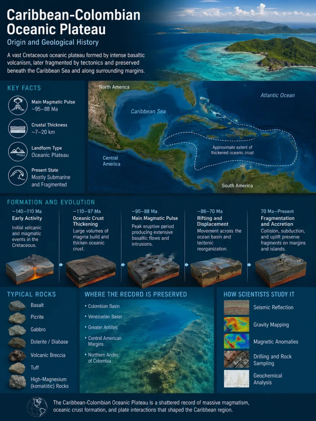
The Caribbean-Colombian Oceanic Plateau is the fragmented remains of an unusually thick Cretaceous oceanic crustal province that formed in the eastern Pacific and later became incorporated into the Caribbean region and the northern Andes. Its history is more complicated than a single burst of plume volcanism: geological, geochemical, magnetic, and seismic evidence now points to prolonged magma production, interaction with an oceanic spreading system, major volcanic pulses, and later fragmentation as the plateau encountered subduction zones and continental margins.
The Plateau, the Caribbean Plate, and the Igneous Province Are Not Identical
Several related names are used for this Cretaceous crust, but they describe different aspects of the same geological history. The Caribbean-Colombian Oceanic Plateau, often abbreviated CCOP, emphasizes the thickened oceanic crust. The Caribbean Large Igneous Province, or CLIP, emphasizes the enormous volume of basaltic and intrusive magma involved in building that crust.
The modern Caribbean Plate is a tectonic plate. It contains a large amount of plateau-related crust, but the entire plate should not be treated as one uniform block of CCOP material. Parts of the Colombian and Venezuelan basins contain much thinner oceanic crust beside markedly thicker plateau crust, while fragments with similar geological affinities now occur on islands and within continental mountain belts far from the present deep Caribbean Sea.
Terminology Matters
CCOP and CLIP overlap strongly in geological usage, but neither term is simply another name for the modern Caribbean Plate. The present plate also contains arc crust, normal or relatively thin oceanic crust, sedimentary basins, and tectonically modified margins.
Why the Caribbean Crust Was Recognized as an Oceanic Plateau
Normal oceanic crust is commonly only several kilometres thick. Much of the central Caribbean instead contains mafic crust roughly 7–20 km thick, depending on location and how the crustal boundary is defined. That excess thickness was one of the earliest indications that ordinary seafloor spreading could not explain the region by itself.
Drilling, dredging, island exposures, and rocks accreted onto surrounding continental margins revealed extensive basaltic sequences, intrusive rocks, gabbros, and locally very magnesium-rich volcanic rocks. Their chemistry generally points to unusually high degrees of mantle melting rather than ordinary production of mid-ocean-ridge basalt alone.
The crust is also highly variable. High-resolution seismic mapping in the Colombian Basin has identified plateau crust around 12–16 km thick close to much thinner zones. Across one interpreted transform system, crustal thickness changes abruptly from about 16 km to less than 4 km in places. That contrast is important because it shows that the plateau is not a single layer of basalt with a uniform thickness.
Basaltic lava flows, volcanic deposits, and locally sediment between eruptive units.
Dikes, sills, intrusive bodies, and thick volcanic packages added far more material than surface flows alone suggest.
Gabbroic and related intrusive material formed as magma crystallized at depth.
Sustained mantle melting supplied the magma that thickened the oceanic lithosphere.
The diagram is conceptual rather than a scale cross-section; real crustal thickness and internal structure vary across the province.
The Origin Story Is No Longer Just a Short Plume-Head Event
A long-standing model connects the Caribbean plateau to a hot mantle plume, commonly linked to the ancestral Galápagos hotspot. In its simplest form, a large plume head rose beneath oceanic lithosphere, underwent extensive decompression melting, and rapidly produced enough basaltic magma to thicken the seafloor into an oceanic plateau.
That model explains several important observations. Many plateau rocks carry trace-element and radiogenic-isotope characteristics associated with a heterogeneous mantle source rather than a simple depleted mid-ocean-ridge mantle. Petrological estimates also require unusually hot mantle and high degrees of melting.
The problem is the duration and structure of the magmatism. The geological record does not fit neatly into one brief volcanic pulse. Older age compilations already indicated several Cretaceous eruptive phases. More recent work strengthens the case for magma production continuing over tens of millions of years.
Simplified Earlier Model
- A large plume head reaches the base of oceanic lithosphere.
- Very high melt production creates thick plateau crust.
- Most construction is concentrated in a relatively short interval near 90 Ma.
- The completed plateau later moves toward the Caribbean region.
Broader Emerging Model
- Enhanced mantle melting continues through a much longer interval.
- A spreading ridge focuses magma and creates new oceanic crust at the same time.
- Several pulses occur within the prolonged magmatic history.
- Subduction geometry and mantle flow may also influence the source of melting.
The two interpretations are not completely incompatible. A mantle thermal anomaly can supply large amounts of melt while a spreading ridge determines where much of that magma rises and how the new crust is organized. The main change is that the plateau no longer needs to be pictured as an already existing seafloor covered by one enormous eruption.
An Extinct Spreading System Beneath the Colombian Basin Changes the Reconstruction
Three-dimensional seismic reflection data have added a new structural component to the origin of the plateau. A 2025 interpretation of the Colombian Basin identified an east-west-trending extinct spreading-ridge system associated with the formation of thick CLIP crust and adjacent areas of thinner oceanic crust.
When 3D seismic observations are combined with regional gravity and magnetic data, the proposed ridge-and-fracture-zone system extends for about 2,220 km across the Colombian and Venezuelan basin region. It is not a single uninterrupted crack. The reconstruction includes ridge segments offset by northeast-trending transform faults.
The transform zones help explain some of the abrupt lateral changes in crustal thickness. In parts of the Colombian Basin, the Moho becomes more than 10 km shallower over a short horizontal distance, while thick plateau crust gives way to very thin oceanic crust. This is the kind of structural pattern expected where magma supply, spreading, and transform tectonics varied along a ridge system.
Seaward-Dipping Reflectors Record Large Volcanic Packages
Seismic profiles also reveal packages of seaward-dipping reflectors, commonly shortened to SDRs. These are wedge-shaped sets of strong seismic reflections associated with thick volcanic sequences and faults near volcanic spreading centres.
In the Colombian Basin, their geometry supports a relationship between basalt eruption and active seafloor spreading. Rather than treating volcanism and crustal extension as separate events, the seismic evidence allows them to be interpreted as parts of the same crust-building system.
Unusually hot or strongly upwelling mantle produces far more magma than normal oceanic spreading.
Extensional faults and ridge segments provide pathways through the oceanic lithosphere.
Lava flows, sills, dikes, and deeper intrusions accumulate through repeated magmatic episodes.
The resulting crust becomes much thicker and more heterogeneous than ordinary seafloor.
The Geological Clock Records Prolonged Construction and Shorter Magmatic Peaks
Different age ranges reported for the Caribbean-Colombian province can appear contradictory until they are separated by what they measure. A broad magmatic history, the interval of most voluminous construction, and the highest-flux volcanic peak are not the same thing.
Earlier Cretaceous Magmatism
Some plateau-related age compilations contain an Aptian phase that predates the dominant Late Cretaceous volcanic record. The relationship of every older unit to the later main plateau remains less secure than the younger record.
Prolonged Ridge-Associated Construction
Magnetic anomalies, seismic interpretations, and basalt ages have been used to argue that seafloor spreading and CLIP-related magmatism overlapped from the Albian into the Campanian. This model gives the plateau a construction history lasting more than 30 million years.
High-Volume Plateau Growth
Modern age reviews continue to identify this interval as the principal voluminous phase preserved across much of the province. It represents especially intense production within the longer magmatic history.
Peak Volcanic Flux
Revised geochronology places a particularly strong eruptive peak in this interval. Its timing has become important because it overlaps with major oceanographic changes associated with Oceanic Anoxic Event 3.
Waning and Continued Magmatism
Some spreading segments appear to have produced thinner crust as magma supply declined. Other plateau-related records indicate that localized magmatism continued beyond the main high-volume phase and in some areas to younger than 70 Ma.
Why the Ages Are Not One Number
Calling the plateau simply “90 million years old” hides its internal history. Around 90 Ma is a useful shorthand for major plateau growth, but the preserved record includes older magmatism, a prolonged period of crust formation, a narrower high-flux peak, and younger activity.
Plume, Ridge, and Subduction May Have Worked Together
The debate over CCOP origin is often presented as a choice between a mantle plume and plate tectonics. The geological evidence allows a more complex interaction.
The Paleo-Galápagos Connection
Trace elements and radiogenic isotopes have long supported a mantle-plume component in many Caribbean plateau rocks. Their characteristics have frequently been compared with the Galápagos mantle system, leading to the model that the plateau formed over or near an ancestral Galápagos hotspot in the eastern Pacific.
The association is plausible but should not be treated as a perfectly fixed geographic point. Hotspots can move relative to the deep mantle, plates change direction, and reconstructed Cretaceous plate boundaries are uncertain. The source also appears chemically heterogeneous rather than representing one uniform batch of plume magma.
A Ridge Could Have Focused the Melt
The extinct spreading system offers a physical route for sustaining magma emplacement. If a ridge crossed an area of unusually high mantle melt production, decompression at the spreading centre could focus magma repeatedly along the same broad zone. This helps explain both the enormous crustal volume and a history lasting much longer than a short plume-head pulse.
Subduction May Have Reorganized Mantle Flow
A separate geodynamic model proposes that changes in Cretaceous subduction helped generate the mantle upwelling responsible for CLIP magmatism. In numerical simulations, collision involving older Caribbean plateau crust changes subduction geometry, produces slab break-off and polarity reversal, opens and later closes a mantle window, and reorganizes mantle circulation strongly enough to generate a plume-like upwelling.
The model can reproduce very high degrees of mantle melting and crustal thicknesses broadly comparable with those observed in the Caribbean. It demonstrates that a plume-like thermal anomaly does not necessarily have to originate as an isolated deep-mantle event independent of surrounding plate boundaries.
A Model Is Not a Unique Solution
Numerical reproduction of the observed crust proves that the proposed process is physically possible, not that every part of the CCOP was produced by one mechanism. Plume-related geochemistry, spreading-ridge structure, and changing subduction geometry may record different parts of one evolving system.
Parts of the Plateau May Have Reached Shallow Water or Emerged Above Sea Level
An oceanic plateau forms from oceanic lithosphere, but that does not mean its entire volcanic surface always remained in deep water. The great thickness and thermal buoyancy of newly formed plateau crust could raise parts of the seafloor considerably.
Seismic interpretations of the Colombian Basin, shallow-water sedimentary evidence, volcanic deposits from other plateau fragments, and records of explosive eruption have all been used to argue that some Late Cretaceous sections formed in shallow marine or subaerial environments.
This matters for reconstructing the original landscape. A thick volcanic swell may have supported islands, emergent volcanic ridges, or broad shallow platforms while neighboring parts of the province remained submerged.
What Subaerial Evidence Does Not Mean
Local emergence does not imply that the entire Caribbean-Colombian Oceanic Plateau was a continent-sized landmass. The evidence supports spatially variable topography across an enormous volcanic province.
The Original Plateau Is Now a Dispersed Geological Record
The CCOP cannot be understood from one modern landform or one continuous outcrop. Much of it remains beneath the Caribbean Sea, while other pieces were faulted, uplifted, subducted, or accreted onto surrounding margins. Each surviving area records a different part of the plateau’s history.
| Area | What the Record Reveals |
|---|---|
| Colombian Basin | Deep crustal thickness, extinct ridge segments, transform faults, SDRs, and transitions between plateau and thin oceanic crust. |
| Venezuelan Basin | Magnetic and regional geophysical evidence used to extend the Late Cretaceous spreading reconstruction eastward. |
| Curaçao and Aruba | Accessible Cretaceous volcanic and intrusive sequences that record plateau magmatism followed by tectonic and arc-related events. |
| Beata Ridge and Hispaniola | Submarine and exposed volcanic sequences showing prolonged and compositionally varied magmatism, including evidence for local emergence. |
| Western Colombia | Accreted basaltic, gabbroic, and sedimentary terranes that show how plateau crust became incorporated into the northern Andes. |
| Guajira Basin | Buried igneous basement sampled offshore, adding direct evidence for plateau-related crust along northern Colombia. |
| Gorgona Island | Exceptional komatiites, picrites, basalts, and ultramafic rocks that reveal extreme mantle melting, although its membership in the same plateau remains debated. |
| Costa Rica | Accreted igneous terranes and sedimentary records that help connect Late Cretaceous volcanism with environmental events such as OAE3. |
The Guajira Basin Adds a Buried Colombian Fragment
Most easily recognized plateau remnants occur as exposed volcanic terranes or as deep Caribbean crust imaged geophysically. Offshore northern Colombia provides another type of evidence: direct sampling of buried igneous basement.
The Orca-1 exploratory well in the Guajira Basin penetrated at least 200 m of igneous basement composed mainly of basalt and andesite, with some pyroclastic material deposited under water. Mineral alteration indicates interaction with low-temperature hydrothermal fluids after emplacement.
Geochemical analysis shows a tholeiitic affinity and was interpreted as evidence for a plume-related source without a clear subduction component in the original magma. The rocks have therefore been proposed as a fragment of CLIP oceanic crust that was later accreted to the margin of the Guajira Peninsula.
The Guajira record is useful because it demonstrates why the modern outline of the province cannot be reconstructed only from surface geology. Some pieces are hidden beneath younger sedimentary basins and are recognized only through drilling and geophysics.
Gorgona Records Extreme Mantle Melting but Has a Complicated Relationship to the CCOP
Gorgona Island, off Colombia’s Pacific coast, contains one of the most unusual Cretaceous volcanic suites associated with discussions of Caribbean plateau magmatism. Its rocks include basalts, gabbros, picrites, dunites, wehrlites, and rare komatiites—very magnesium-rich lavas far more characteristic of the much hotter mantle conditions of early Earth history.
The island therefore provides unusually direct evidence for very high-temperature or high-degree mantle melting during the Cretaceous. Its volcanic and intrusive rocks are also chemically heterogeneous, showing that the mantle source feeding these magmas was not uniform.
Gorgona should not, however, be treated as an uncomplicated sample of the entire Caribbean-Colombian plateau. One line of interpretation places its formation near 26° south paleolatitude and its accretion against northwestern South America in the Eocene, later than the main Late Cretaceous accretion of CCOP-related crust in western Colombia. These differences led to the proposal that Gorgona belonged to a separate Late Cretaceous oceanic plateau.
Other studies have continued to use Gorgona to investigate CLIP mantle components and prolonged Caribbean-related magmatism. Its geological affinity therefore remains an example of a broader problem: rocks of similar age and plume-like chemistry around the eastern Pacific and Caribbean region do not automatically prove that every fragment belonged to one originally continuous plateau.
Thick Plateau Crust Changed What Happened at Subduction Zones
Once formed, the plateau did not remain near its original volcanic centre. Plate reconstructions generally place its main development in the eastern Pacific, followed by movement toward the gap between North and South America.
Thick oceanic plateau crust behaves differently from ordinary aging oceanic lithosphere when it reaches a convergent margin. A newly formed plateau contains a thicker crustal section and can be relatively buoyant. Complete subduction therefore becomes more difficult, although not impossible.
Collision with an arc or trench can instead produce several responses: parts of the plateau may be scraped from the downgoing plate, fault slices can become accreted to the overriding margin, slabs can tear or break, and the geometry or polarity of subduction can change.
This mechanical behavior helps explain both the survival of CCOP fragments and their broad distribution. Much of the original oceanic province has been tectonically modified, but resistant pieces became incorporated into island arcs, Caribbean margins, Central America, and northwestern South America.
Eastward Transport Reshaped the Cretaceous Caribbean
The dominant plate-tectonic reconstructions place much of the plateau on Pacific-derived oceanic lithosphere rather than forming it entirely within the space of the modern Caribbean Sea. As the relevant oceanic plate system moved northeastward or eastward, the plateau approached the convergent margins bordering the proto-Caribbean region.
Its arrival altered an already complex arrangement of arcs, trenches, spreading systems, and continental margins. Because an oceanic plateau is harder to consume than ordinary oceanic crust, its collision could reorganize subduction instead of allowing the existing geometry to continue unchanged.
Subduction Polarity Reversal
One influential reconstruction links plateau collision to a reversal in the direction of subduction. In such a process, an older subduction configuration becomes mechanically unstable, and a new slab begins descending in the opposite direction along another margin.
Geodynamic simulations have shown how collision involving older Caribbean plateau crust could cause slab break-off, initiate westward subduction of proto-Caribbean lithosphere, open a mantle window, and later reorganize mantle flow as subduction developed along the western side of the moving plateau.
This process provides a link between two parts of the CCOP story that were once treated separately: the tectonic transfer of the plateau into the Caribbean and the mantle processes capable of supplying later large-volume magmatism.
How Plateau Crust Became Part of Colombia and the Northern Andes
The word “Colombian” in Caribbean-Colombian Oceanic Plateau reflects more than geographic proximity. Large bodies of Cretaceous mafic oceanic rock in western Colombia are interpreted as fragments of oceanic plateau crust attached to the continental margin during convergence.
The Western Cordillera of Colombia contains major Cretaceous sedimentary, basaltic, and gabbroic units associated with the plateau. Geological reconstructions place their accretion mainly from the Late Cretaceous into the Paleogene.
These rocks did not begin as continental Andean crust. They formed in an oceanic environment and were later transferred to the edge of South America along faults and sutures. Subsequent compression, faulting, uplift, magmatism, and erosion incorporated them into the architecture of the northern Andes.
The Plateau Did Not Create the Andes by Itself
Accretion of CCOP-related crust added oceanic material to the western margin of Colombia and influenced regional tectonics. The Andes, however, result from a much longer history of plate convergence, terrane accretion, subduction, magmatism, deformation, and uplift.
Peak Volcanism at 88–86 Ma May Be Connected to Oceanic Anoxic Event 3
The environmental effects of the Caribbean Large Igneous Province are receiving renewed attention because improved age control places its strongest Late Cretaceous volcanic activity close to major changes in ocean chemistry.
Oceanic Anoxic Event 3, or OAE3, developed broadly from about 88 to 84 Ma. It was not a single globally uniform episode, but a prolonged interval when oxygen-poor marine conditions and organic-rich sediment deposition expanded in several ocean basins.
A 2026 synthesis places the peak phase of Caribbean LIP volcanism at approximately 88–86 Ma. Black shales in the Loma Chumico Formation of Costa Rica have been dated to about 88–87 Ma, closely matching the beginning of OAE3 and the strongest reconstructed volcanic flux.
Why Mercury Records Matter
Large volcanic provinces can release mercury to the atmosphere and oceans. When unusually high mercury concentrations appear in marine sediments at the same stratigraphic level as carbon-cycle disturbances, they can provide an independent proxy for major volcanic activity.
Mercury records from deep-ocean drilling sites, calibrated against carbon-isotope changes, indicate enhanced volcanic input shortly before and during OAE3. Combined with the revised age of Caribbean volcanism, this strengthens the possibility that the province contributed to the environmental changes.
The Proposed Causal Chain
A major eruptive phase releases volcanic gases and alters oceanic crust on a very large scale.
Volcanic emissions, warming, weathering, and hydrothermal processes can alter marine productivity and ocean chemistry.
Greater organic-matter production and decay can consume dissolved oxygen, especially where circulation already limits ventilation.
Low-oxygen bottom waters improve preservation of organic matter in marine sediment.
The Timing Is Stronger Than Proof of a Single Cause
The close overlap between the 88–86 Ma volcanic peak, mercury anomalies, carbon-cycle disruption, and the onset of OAE3 strengthens a causal interpretation. It does not mean Caribbean volcanism alone controlled oxygen conditions in every ocean basin; circulation, climate, nutrient supply, basin geometry, and other feedbacks also mattered.
OAE2 Has a Different Relationship to the Plateau
The Caribbean province has also been discussed in relation to Oceanic Anoxic Event 2 near 94 Ma. The broader duration now recognized for CLIP magmatism means volcanic activity was occurring during this interval, so a contribution to the carbon cycle and marine environment is plausible.
The chronological relationship is less straightforward than the newly emphasized 88–86 Ma peak and OAE3. OAE2 was a major global event associated with several interacting volcanic, climatic, and oceanographic processes. Assigning it to the Caribbean plateau alone would therefore go beyond the available evidence.
Separating the two anoxic events is important. OAE2 occurs near 94 Ma, whereas OAE3 begins around 88 Ma and extends through a longer, less globally uniform interval. The strongest current chronological match for peak Caribbean volcanism lies with the beginning of OAE3.
Scientists Reconstruct the Plateau from Different Types of Evidence
No single dataset can reconstruct a volcanic province that is partly submerged, partly accreted to continents, partly deformed, and partly lost to subduction. The origin model depends on combining evidence that answers different questions.
| Evidence | What It Can Constrain |
|---|---|
| 3D seismic reflection | Crustal architecture, faults, extinct ridge geometry, volcanic reflectors, and buried basement structure. |
| Seismic refraction | Crustal thickness, seismic velocity, and approximate position of the Moho. |
| Marine magnetic anomalies | Orientation and age patterns associated with seafloor spreading. |
| Gravity data | Regional crustal boundaries and structures that extend beyond individual seismic surveys. |
| 40Ar/39Ar geochronology | Ages of basaltic volcanic and intrusive rocks. |
| U-Pb zircon geochronology | Ages of zircon-bearing volcanic ash, volcaniclastic material, and selected igneous units. |
| Trace elements and radiogenic isotopes | Mantle-source composition, degree of melting, and relationships between different magmatic groups. |
| Paleomagnetism | Approximate formation latitude, later rotation, and testing of competing plate reconstructions. |
| Field stratigraphy | Whether volcanism occurred in deep marine, shallow marine, or locally subaerial conditions. |
| Offshore drilling | Direct samples of plateau-related basement otherwise hidden beneath the sea or younger sediments. |
Why the Original Boundary Cannot Be Drawn as a Precise Modern Outline
The CCOP is sometimes shown on maps as though it were a simple Cretaceous volcanic platform with a known perimeter. Its original geometry is much less certain.
More than 70 million years of plate motion have changed the province. Parts were subducted. Other pieces became attached to continental margins. Faults displaced blocks laterally. Arc magmatism intruded plateau crust. Some areas were rotated, uplifted, eroded, or buried beneath younger sediments. Even within the Colombian Basin, thick plateau crust occurs beside thinner oceanic domains produced during the same broad tectono-magmatic episode.
For that reason, numerical estimates of the original area or magma volume depend heavily on which crustal fragments are assigned to the province and how much missing crust is reconstructed. A single exact boundary would imply a level of certainty that the surviving geology does not provide.
A Continuous Reconstruction of the Plateau’s Geological History
Oceanic Lithosphere and Earlier Magmatism
Oceanic crust already existed within the eastern Pacific–proto-Caribbean plate system, while some volcanic records show magmatism predating the main Late Cretaceous plateau-building phase.
Spreading and Mantle Melt Supply Intensify
An active spreading system operates while unusually large amounts of magma rise from the mantle. New oceanic crust and thickened plateau crust begin developing within the same regional system.
Large-Volume Plateau Growth
Repeated basaltic eruptions and intrusive additions build thick mafic crust. Parts of the swollen volcanic surface reach shallow-water or subaerial conditions.
Peak Magmatic Output
A high-flux volcanic phase overlaps the beginning of OAE3 and becomes one of the clearest time links between Caribbean plateau volcanism and global environmental disturbance.
Subduction Systems Reorganize
As thick plateau lithosphere reaches convergent margins, subduction geometry changes. Arc interaction, polarity reversal, slab break-off, and mantle-flow reorganization become part of the regional tectonic evolution.
Fragments Accrete Around the Caribbean and Northern Andes
Parts of the plateau are preserved instead of being completely subducted. Oceanic terranes become attached to Colombia and other surrounding margins while the remaining crust continues into the developing Caribbean region.
A Dismembered Plateau Remains
Its history survives in deep Caribbean crust, extinct spreading structures, island exposures, accreted Andean terranes, offshore basement, and scattered volcanic sequences rather than as one intact plateau surface.
What Remains Unresolved About the Caribbean-Colombian Oceanic Plateau
Several parts of the geological history are well supported: the Caribbean contains unusually thick Cretaceous oceanic crust; large-volume basaltic magmatism lasted much longer than one eruptive episode; spreading structures occur within the Colombian Basin; plateau fragments were transported and accreted around the Caribbean and northern South America; and a major volcanic peak occurred close to 88–86 Ma.
Other questions remain open because the original province has been fragmented and partly destroyed by plate tectonics:
- How much of the magma source came from a deep Galápagos-related plume and how much was generated or modified by regional mantle-flow reorganization?
- Was the same plume responsible for every magmatic phase now grouped with the Caribbean province?
- How far did the proposed Cretaceous spreading-ridge system extend beyond the parts constrained by modern geophysical data?
- What proportion of the original plateau has since been subducted and is therefore missing from surface reconstructions?
- Which accreted terranes belong to the main Caribbean plateau and which, such as the proposed Gorgona Plateau, may represent separate Cretaceous oceanic plateaus?
- How much did Caribbean volcanism contribute to OAE2 compared with other volcanic and oceanographic processes?
- Did the 88–86 Ma volcanic peak directly help trigger OAE3, or was it one forcing mechanism within a larger set of climate and ocean-circulation changes?
- How much of the plateau stood above sea level at different times during its construction?