INTERACTIVE CONTEXT MAP
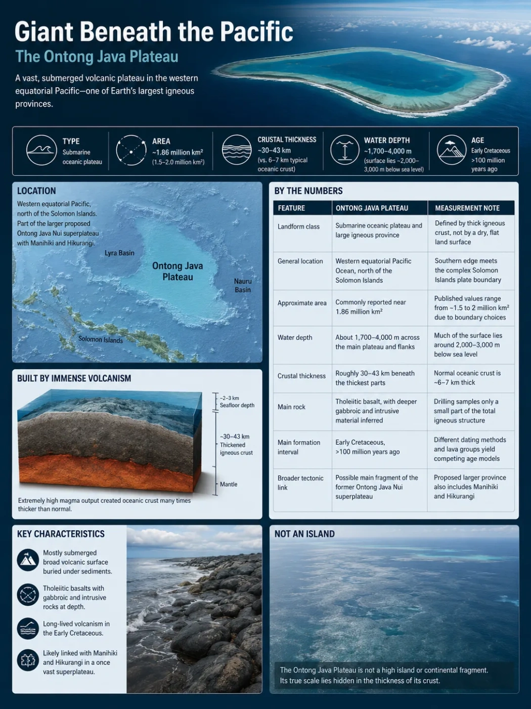
Where is Ontong Java Plateau?
The selected plateau and nearby mapped locations are shown. Open the full world atlas to explore every region.
Submarine Plateau · Western Equatorial Pacific
The Ontong Java Plateau is an immense body of thickened oceanic crust north of the Solomon Islands. Its broad volcanic surface lies mostly two to four kilometres below sea level, while its deeper structure records one of the largest known episodes of magma production on Earth.
The Ontong Java Plateau is not a high tableland in the ordinary land-based sense. It is a submerged volcanic plateau: a wide region where the Pacific Plate carries oceanic crust several times thicker than normal. Its visible relief is modest compared with its hidden mass. Much of the plateau surface is buried beneath carbonate sediment, while the larger share of its igneous volume sits within the crust and uppermost mantle.
Its size, unusual crust, long lava flows and mostly submarine origin make it a test case for how oceanic plateaus form. The main questions are no longer limited to how much basalt erupted. They also concern where the magma moved, how long activity lasted, why the plateau did not rise into a broad continent-sized island, and whether it once joined the Manihiki and Hikurangi plateaus in a larger volcanic province.
| Feature | Ontong Java Plateau | Measurement Note |
|---|---|---|
| Landform class | Submarine oceanic plateau and large igneous province | Defined by thick igneous crust, not by a dry, flat land surface |
| General location | Western equatorial Pacific Ocean, north of the Solomon Islands | Its southern edge meets the complex Solomon Islands plate boundary |
| Approximate area | Commonly reported near 1.86 million km² | Published values range from roughly 1.5 to 2 million km² because plateau boundaries are drawn in different ways |
| Water depth | About 1,700–4,000 m across the main plateau and its flanks | Much of the broad surface lies around 2,000–3,000 m below sea level |
| Crustal thickness | Roughly 30–43 km beneath the thickest parts | Normal oceanic crust is commonly only about 6–7 km thick |
| Main rock | Tholeiitic basalt, with deeper gabbroic and intrusive material inferred | Drilling samples only a small part of the total igneous structure |
| Main formation interval | Early Cretaceous, more than 100 million years ago | Different dating methods and sampled lava groups produce competing age models |
| Broader tectonic link | Possible main fragment of the former Ontong Java Nui superplateau | The proposed larger province also includes Manihiki and Hikurangi |
Measurement Note
The plateau has no universally agreed shoreline or administrative border. Area estimates change depending on whether a study follows the clear bathymetric rise, the thick-crust boundary, the eastern salient, or related Early Cretaceous lava fields in nearby ocean basins.
Position in the Pacific and the Limits of a Map Pin
The plateau occupies a broad part of the western equatorial Pacific. The Solomon Islands lie along its southern margin. The Nauru Basin is to the east and northeast, the East Mariana and Pigafetta regions lie farther north, and the Lyra Basin borders the western side. The Ellice and Stewart basin systems separate or cut into parts of the eastern plateau region.
Map Note
The map is useful for regional orientation, but it does not show the scientific boundary of the plateau. Some map services may emphasize Ontong Java Atoll rather than the much larger submarine plateau beneath the surrounding ocean.
Common Mix-Up
Ontong Java Atoll is a coral atoll in Solomon Islands territory. Ontong Java Plateau is the vast submarine igneous landform beneath a much larger part of the Pacific seafloor. The atoll sits on a younger volcanic and carbonate structure associated with the plateau, but it is not the plateau itself.
A Plateau Defined by Thick Crust, Not a Flat Surface
On land, a plateau is usually recognized by elevation above nearby terrain and a broad upper surface. An oceanic plateau is identified differently. Bathymetry shows a large seafloor rise, but seismic data reveal the defining feature: an unusually thick body of igneous crust.
The Ontong Java Plateau rises above surrounding abyssal basins that are commonly four to five kilometres deep. Its own upper surface is generally shallower, yet it remains submerged. The change in depth is gradual across some margins and sharper across others, so the plateau does not resemble a single flat-topped block.
It contains a central high region, an eastern extension, broad slopes, structural lows, ridges, seamounts and deep submarine canyons. Sediment has softened much of the volcanic relief. This makes the present seafloor smoother than the igneous basement hidden below it.
No Rivers, but a Large Submarine Drainage System
Because the plateau is underwater, it has no terrestrial rivers or conventional drainage basin. Sediment instead moves through submarine channels, canyon systems, slope failures and turbidity currents. These processes carry carbonate fragments, volcanic material and other sediment from atolls and high areas toward deeper basins.
Kroenke Canyon is the clearest example. It cuts across the northeastern part of the plateau for roughly 500 km and opens toward the Nauru Basin. Sediment supplied from the flanks of Ontong Java and Nukumanu atolls has helped shape parts of this canyon system.
Why Published Area Figures Do Not Match
A commonly used area is about 1.86 million km², but estimates near 1.5 million and 2 million km² also appear in geological literature. These values can all describe reasonable interpretations of the same landform.
The Bathymetric Plateau
The narrowest approach follows the raised seafloor that is clearly distinguishable from the surrounding abyssal basins. This method may exclude thinner marginal crust and distant lava fields that are genetically related to the plateau.
The Thick-Crust Province
Seismic and gravity studies can trace crust that is thicker than ordinary Pacific oceanic crust. This boundary does not always match the visible break in seafloor depth. Magmatic underplating and intrusive bodies may extend beyond the obvious topographic rise.
The Greater Volcanic Province
Early Cretaceous basalts in the Nauru, East Mariana and Pigafetta basins may be linked to the same broad volcanic episode. Including those flows produces a volcanic province larger than the plateau proper.
The Ontong Java Nui Reconstruction
The largest estimates concern a restored Cretaceous province in which Ontong Java, Manihiki and Hikurangi formed together before seafloor spreading carried them apart. That reconstructed province is not the same measurement as the modern Ontong Java Plateau.
Area and volume should not be combined from unrelated definitions. A surface-area figure for the modern bathymetric plateau cannot safely be paired with a magma-volume estimate for the reconstructed Ontong Java Nui province without explaining the difference.
The Main Seafloor Provinces
The High Plateau
The central and western high plateau contains the thickest crust and some of the shallowest broad seafloor on the structure. Scientific drilling sites on this region recovered thick carbonate sequences above basaltic basement. The high plateau is the part most often used when estimating the plateau’s maximum crustal thickness.
The Eastern Salient
The Eastern Salient projects eastward from the main plateau. It matters because plate reconstructions place it near the proposed junction between Ontong Java, Manihiki and Hikurangi before their separation. Dredged volcanic rocks from this margin include compositions and ages that strengthen the idea of a former connection with Manihiki.
Stewart Basin and the Eastern Lobe
The eastern lobe is not one unbroken platform. A northern ridge and the Stewart Arch are separated by the Stewart Basin, which records rifting and seafloor spreading within the wider plateau region. Reconstructions suggest that nearly 300 km of spreading may have separated the northern and southern parts of this eastern lobe.
Kroenke Canyon
Kroenke Canyon is not evidence that a river once crossed a dry plateau. It is a submarine erosional and depositional system. Its scale shows that deep-sea currents and sediment gravity flows can cut major relief into an apparently smooth oceanic plateau.
Seamounts and Atolls
Later volcanic centres and coral growth have added younger features to the plateau surface. Their ages and magma chemistry may differ from the main Early Cretaceous plateau-forming event. A seamount rising from the plateau therefore cannot automatically be treated as part of the original main lava sequence.
A Crustal Body Several Times Thicker Than Normal Ocean Floor
The most remarkable part of the Ontong Java Plateau is below the sediment. Seismic studies place the Moho—the boundary between crust and mantle—roughly 30 to 43 km below the seafloor beneath thick parts of the plateau. By comparison, ordinary oceanic crust is commonly about 6–7 km thick.
This does not mean that 30–43 km of lava accumulated at the surface. The crust includes several components:
- Pelagic carbonate and other marine sediment covering the volcanic basement.
- Basaltic lava flows, including pillow lava and massive flows erupted on or near the seafloor.
- Volcaniclastic layers formed by explosive or fragment-producing eruptions.
- Sheeted intrusions and dikes that carried magma vertically and laterally.
- Gabbroic lower crust produced as magma cooled more slowly at depth.
- Magmatic underplating near the base of the crust, where dense melt accumulated and crystallized.
Some models estimate a total igneous or crustal volume near 50–57 million km³. Such values depend heavily on crustal geometry, density assumptions and the mapped boundary. The volume of erupted lava at the seafloor is much smaller than the total volume of melt stored within and beneath the crust.
Field Note
Only a few drill holes have penetrated the basaltic basement. The plateau is so large that drilling samples resemble small pinpricks in a structure wider than many countries. Seismic waves and gravity data are therefore needed to extend local rock observations across the whole plateau.
Fossil Magma Pathways Beneath the Plateau
Recent high-frequency seismic analysis has added a clearer picture of the magma plumbing system. The lithosphere beneath the plateau appears to contain a hybrid structure of horizontal layers crossed by large dike swarms. The dikes are interpreted as fossil pathways through which plume-derived magma rose through pre-existing oceanic lithosphere.
The underlying lithospheric mantle also transmits seismic waves more slowly than expected for ordinary old oceanic lithosphere. Fractures alone may not explain this pattern. One interpretation is that rising magma chemically altered, or refertilized, the mantle rock by adding new minerals and melt-derived components.
This finding changes the simple image of lava piling up from above. The plateau-forming event reorganized the entire oceanic plate section, from surface flows to deep mantle lithosphere.
How the Magma Built the Plateau
A Large Mantle Upwelling Reached the Plate
Hot mantle containing an easily melted, dense component rose beneath Early Cretaceous Pacific lithosphere.
Decompression Produced Vast Melt Volumes
Pressure fell as the mantle rose. Partial melting generated much more magma than ordinary mid-ocean ridge processes normally produce.
Magma Spread Below and Through the Lithosphere
Melt collected near the crust–mantle boundary, entered dike swarms and fed intrusions through the existing oceanic plate.
Repeated Flows Covered the Seafloor
Fluid basalt travelled across broad submarine surfaces, forming stacked flows, pillow lavas and locally fragmental volcanic deposits.
Cooling Left a Thick Igneous Plateau
Surface lava, middle-crust intrusions, lower-crust gabbro and underplated material combined to form the present thick crustal body.
Why a Single Central Volcano Is the Wrong Model
The plateau did not grow from one cone or one caldera. Its scale requires a distributed magmatic system active across a very wide region. Long lava flows, multiple basement sites, broad intrusive zones and regional dike swarms point to many vents and fissures connected to a deeper melt supply.
Some submarine lava flows may have travelled extraordinary distances because basaltic magma was fluid, the slopes were gentle and cooling conditions beneath water allowed insulated flow interiors to remain mobile. Very long flows do not require one violent explosive event; they can form through sustained delivery of low-viscosity lava.
The Basalt Groups Preserve Different Parts of the Eruptive Record
The drilled and exposed basement is dominated by tholeiitic basalt. Researchers commonly divide the sampled lavas into several compositional groups. These are not simply labels for different locations. Their trace elements and isotopes help identify mantle sources, melting conditions and changes during construction of the plateau.
| Basalt Group | General Character | Geological Use |
|---|---|---|
| Kwaimbaita | The most widespread and volumetrically dominant sampled type | Represents a major part of the main plateau-forming magma supply |
| Kroenke | Related to Kwaimbaita but commonly more magnesium-rich in sampled sequences | Helps trace hotter or less evolved parts of the principal magma system |
| Singgalo | More enriched in several incompatible elements and isotopic traits | Points to a distinct or more enriched mantle component and may mark changes in eruption style or source mixture |
| Wairahito and younger suites | Includes later or regionally distinct volcanic products | Separates main plateau construction from later volcanic episodes |
Kwaimbaita-like basalt is found across widely separated drill and land-exposure sites. This broad chemical similarity suggests that a large volume of mantle melted under related conditions. Singgalo-like material records a more enriched component and may represent a later or spatially restricted phase.
Volcaniclastic deposits at Site 1184 add another layer to the story. They contain evidence of eruptions interacting with shallow water or air. These rocks show that although most of the plateau formed below sea level, some volcanic centres rose into very shallow marine settings and may briefly have emerged.
When Did the Main Eruptions Occur?
The timing remains one of the hardest parts of the Ontong Java story. Basalt altered by seawater can lose or redistribute the isotopes used for dating. Drill holes also recover only small and widely separated parts of the basement.
Rapid Emplacement Near 122–120 Million Years Ago
Biostratigraphy, palaeomagnetism and earlier isotopic ages supported a short main volcanic pulse in the Early Aptian, possibly lasting less than about three million years.
Many Sampled Flows Date to About 117–108 Million Years Ago
High-precision argon dating published in 2023 found several basalt flows younger than the classic model and indicated activity extending for at least six million years.
Sediments Still Record Volcanism Near the Start of OAE1a
Pacific sediment records dated near 120 million years preserve lead, osmium and volcanic signals linked to Ontong Java Nui, including a short explosive phase.
A Smaller Volcanic Episode Occurred Near 90 Million Years Ago
Younger basalt drilled at Site 803 shows that magmatism returned long after the principal plateau-building stage.
Why the Age Models Can Coexist
The older and younger ages may not date the same part of the system. An early explosive or shallow-water phase could have affected the ocean near 120 million years ago, while large sampled lava packages continued later. Some early basement may remain unsampled beneath younger flows. Different basalt groups may also record separate pulses.
The safest description is therefore that the plateau formed through Early Cretaceous magmatism with more than one phase. A single date should not be used for every lava, intrusion, volcaniclastic layer and related basin flow.
The plateau was not created in one instantaneous eruption. “Largest volcanic event” refers to total scale, not to one explosion. Construction involved repeated eruptions, intrusive growth and deep magmatic addition over a span that remains debated.
Why the Mantle Plume Model Had to Change
A hot mantle plume head has long been used to explain the extreme magma volume. The difficulty is buoyancy. A purely thermal plume hot enough to produce the observed crust should also lift the plate strongly, potentially creating a broad region above sea level. Geological evidence instead indicates that most of the plateau remained submarine.
A second idea links formation to exceptionally fast seafloor spreading. Rapid extension could promote decompression melting across a wide region. Yet thermal calculations show that this mechanism may require an unrealistically hot mantle or an unusually high proportion of easily melted material.
Thermodynamic modelling published in 2026 supports a thermochemical plume. In this model, the upwelling was about 135–200°C hotter than ambient mantle and contained as much as roughly 13% dense, fusible pyroxenite. The hot component produced abundant melt. The denser component reduced total buoyancy, helping the plateau remain mostly underwater.
| Formation Model | What It Explains | Main Difficulty |
|---|---|---|
| Purely thermal plume head | Very high melt production and thick crust | May predict more uplift and subaerial exposure than the geological record allows |
| Rapid seafloor spreading | Wide decompression melting and breakup-related structures | May need implausible mantle temperatures or too much fusible material |
| Thermochemical plume | Magma volume, crustal-thickness pattern, lava chemistry and mostly submarine emplacement | Needs further testing with deep samples, broader seismic coverage and improved plate reconstructions |
What Pyroxenite Adds to the Model
Pyroxenite is a dense mantle rock rich in pyroxene. It can form when older oceanic crust and related material are recycled into the mantle. Compared with common peridotite, some pyroxenite compositions begin melting more readily.
A plume carrying both hot peridotite and recycled pyroxenitic material can therefore produce large melt volumes without having the low density expected from temperature alone. This provides a physical link between basalt chemistry, crustal thickness and the lack of continent-scale emergence.
Was the Plateau Ever Above Sea Level?
Most evidence supports predominantly submarine emplacement. Basalt glasses, carbonate cover and palaeodepth estimates indicate that large parts of the plateau formed and remained below sea level.
The answer is not “never.” Volcaniclastic rocks containing accretionary lapilli and signs of phreatomagmatic activity show that some vents reached very shallow water or temporary subaerial conditions. A broad plateau can contain local islands even when most of its surface remains submerged.
This distinction matters. The Ontong Java Plateau was not a lost continent with rivers, soils and a single terrestrial climate. It was a volcanic oceanic platform with scattered high points. Later subsidence, sediment loading, tectonic movement and collision changed its depth and relief.
Landform Note
An oceanic plateau is not classified by a minimum height above sea level. It is recognized by broad seafloor relief, thick crust and an igneous history that differs from ordinary ocean-basin crust.
Ontong Java Nui: One Plateau Broken Into Three?
The Ontong Java Nui hypothesis proposes that the Ontong Java, Manihiki and Hikurangi plateaus formed as connected parts of one huge volcanic province. The pieces later separated as the Ellice and Osbourn basin systems opened.
This idea helps explain similarities in age and basalt chemistry, but the reconstruction is not a perfect jigsaw. The three plateaus have different crustal thicknesses. Their sampled volcanic ages do not fully overlap. The Early Cretaceous magnetic quiet period also removed many of the magnetic reversals normally used to reconstruct seafloor spreading.
Evidence That Supports a Former Connection
- All three plateaus contain Early Cretaceous volcanic rocks.
- Several basalt groups share related isotopic source components.
- Plate reconstructions can place their margins together before later basin opening.
- Rocks dredged from the Ontong Java Eastern Salient include Manihiki-like compositions.
- Newer ages from the eastern margin help bridge part of the earlier age gap between the plateau fragments.
Evidence That Keeps the Hypothesis Open
- Crustal thickness differs strongly among Ontong Java, Manihiki and Hikurangi.
- The precise original shape and palaeolatitude of each fragment remain uncertain.
- Some volcanic suites may reflect later local eruptions rather than the shared main event.
- Different reconstructions arrange the fragments in different positions.
If the three were once connected, the reconstructed volcanic province may have approached 90 million km³ in total magmatic volume in some models. That number applies to a restored superplateau estimate, not to the present Ontong Java Plateau alone.
Breakup Through the Ellice and Osbourn Basins
The proposed superplateau did not remain intact. Seafloor spreading opened the Ellice Basin between Ontong Java and Manihiki and the Osbourn Basin between Manihiki and Hikurangi.
Dating of rocks linked to these basin systems indicates rapid Cretaceous opening. Some reconstructions require very high full spreading rates, locally reaching several tens of centimetres per year. Such rates are unusual and help explain how former neighbours could become separated by thousands of kilometres.
The opening occurred during the Cretaceous Normal Superchron, when Earth’s magnetic field stayed in normal polarity for a long interval. Because standard seafloor reconstructions rely heavily on alternating magnetic stripes, this quiet period leaves fewer markers for measuring the timing and direction of breakup.
Did Ontong Java Volcanism Help Trigger Oceanic Anoxic Event 1a?
Oceanic Anoxic Event 1a, or OAE1a, was an Early Cretaceous interval marked by widespread oxygen loss in the oceans, disrupted carbon cycling and deposition of organic-rich sediment. Ontong Java volcanism has long been proposed as a trigger because enormous eruptions can release carbon, sulfur, metals and heat into the ocean–atmosphere system.
The 2023 basalt ages created a timing problem. If much of the sampled plateau lava erupted between about 117 and 108 million years ago, those flows would be too young to start OAE1a near 120 million years ago. They may instead overlap later environmental disturbances, including parts of OAE1b.
Other records preserve an earlier volcanic signal. Pacific sediments from Magellan Rise contain lead and osmium isotope changes linked to Ontong Java Nui near the beginning of OAE1a. Work published in 2026 identifies a short explosive phase of about 250,000 years, with a transition from Kwaimbaita/Kroenke-like magma toward Singgalo-like magma. That interval coincides with strong volatile release, warming and marine ecological stress.
The combined evidence suggests a phased event:
- An early explosive or shallow-water stage released ash and gases into the ocean–atmosphere system.
- Large submarine lava packages and intrusive growth continued or returned over a longer interval.
- Later volcanic pulses, including activity near 90 million years ago, had separate environmental effects.
The causal link is therefore still studied, but the question is more precise than before. It concerns which volcanic phase produced which environmental signal, rather than whether every part of the plateau formed at the same moment.
The Collision With the Solomon Islands Arc
After formation, Pacific Plate motion carried the plateau westward toward the Solomon Islands arc. Thick oceanic plateau crust is more buoyant than ordinary oceanic crust and does not enter a trench as easily. Its arrival congested the subduction zone north of the arc.
The regional plate system then reorganized. Subduction north of the arc slowed or stopped, while a new subduction system developed on the opposite side. This change is widely used as an example of subduction reversal.
The Malaita Terrane
Parts of the plateau’s southern edge were scraped off, uplifted and exposed on islands including Malaita and Santa Isabel. These rocks form a rare land-based window into an oceanic plateau that is otherwise buried beneath kilometres of water and sediment.
Malaita exposes basalt, deep-sea sediment and younger volcanic rocks. Mantle and lower-crust fragments carried upward by later magmas also provide samples from levels far below the reach of ocean drilling.
The Collision Date Is Still Debated
Models differ on whether collision began through an early “soft docking,” a later Miocene–Pliocene collision, or more than one collision involving separate plateau fragments. The amount of plateau crust that entered the subduction system also remains uncertain.
IODP³ Expedition 504S, published as a 2026 scientific prospectus, is re-examining archived drill cores from the plateau. The study uses the age and chemistry of volcanic ash to test whether ash came from the Solomon arc, regional hotspots or other sources. Those records may show when the plateau approached the arc and when subduction changed sides.
Why the Carbonate and Ash Cover Matters
The volcanic basement is only one part of the plateau archive. After the main eruptions, marine carbonate accumulated for more than 100 million years. At Site 807, the sedimentary section reaches about 1,380 m above basement and grades upward from limestone to chalk and ooze.
This cover records changing ocean chemistry, productivity, dust transport, volcanic ash and equatorial currents. Because the plateau remained near the Equator for much of its later history, its sediments preserve material carried from Asia, Australia, the Americas and nearby volcanic arcs.
Ash layers occur in several Cenozoic intervals rather than only during initial plateau construction. They may record later Melanesian arc volcanism, hotspot activity or distant eruptions. Separating discrete ash beds from fine ash mixed through the carbonate sediment helps reconstruct both volcanic history and long-term Pacific wind patterns.
How Scientists Reconstruct a Plateau Hidden Beneath the Ocean
Scientific Ocean Drilling
DSDP and ODP expeditions recovered sediment and basalt from several sites, including Sites 289, 803, 807 and the Leg 192 sites 1183–1187. Drill cores provide direct evidence for rock type, eruption environment, alteration, sediment age and palaeoceanographic change.
Seismic Refraction and Receiver Functions
Sound waves travel at different speeds through sediment, basalt, gabbro and mantle. Ocean-bottom seismometers use these changes to estimate crustal thickness, locate the Moho and identify boundaries within the lithosphere.
Multichannel Seismic Reflection
Reflected sound reveals stacked lava units, sediment layers, basement relief and deep reflectors. Internal reflections show that the plateau basement contains layered flow packages rather than one uniform mass.
Gravity and Bathymetry
Gravity measurements help test the density and thickness of hidden crust. Multibeam bathymetry maps ridges, slopes, basins, canyons and seamounts at far higher detail than older depth soundings.
Trace Elements and Isotopes
Strontium, neodymium, lead, hafnium and osmium isotopes distinguish mantle components and track volcanic material in distant sediment. They are central to testing the Ontong Java Nui connection and the possible environmental effects of eruption phases.
Radiometric Dating
Argon–argon dating is widely used on basalt, while uranium–lead dating can be used on zircon-bearing material. Seawater alteration, recoil during sample treatment and inherited minerals can complicate results, so ages are compared with fossils, magnetic polarity and sediment stratigraphy.
Terms That Clarify the Geology
Oceanic Plateau
A broad rise in the seafloor underlain by oceanic crust much thicker than ordinary ocean-basin crust.
Large Igneous Province
A region created by magma production far greater than normal background volcanism, often within a geologically limited interval.
Moho
The seismic boundary between Earth’s crust and mantle. Its depth helps show how thick the plateau crust is.
Underplating
The addition and cooling of dense magma near the base of the crust rather than at the seafloor.
Dike Swarm
A network of steep magma-filled fractures. Beneath Ontong Java, ancient swarms may preserve the routes used by plume-derived melt.
Phreatomagmatic Eruption
An eruption driven or intensified when magma meets water, producing fragmented volcanic material.
Subduction Reversal
A reorganization in which subduction ends on one side of an island arc and begins on the other side.
Thermochemical Plume
A mantle upwelling whose behaviour depends on both high temperature and chemical composition, including dense material that melts readily.
Questions Still Being Tested
- How much of the oldest plateau basement remains unsampled beneath younger lava?
- Did the earliest explosive phase occur across the entire Ontong Java Nui province or only near shallow volcanic centres?
- What share of the plateau’s volume formed as seafloor lava, crustal intrusion and mantle underplating?
- How closely did Ontong Java, Manihiki and Hikurangi fit together before the Ellice and Osbourn basins opened?
- Can future deep drilling directly test the pyroxenite-rich thermochemical plume model?
- How far do fossil dike swarms extend beyond the present plateau boundary?
- Which collision model best matches the ash record, deformation of Malaita and regional plate motion?
- How much Ontong Java crust has entered the Solomon subduction system, and how much remains attached to the Pacific Plate?