INTERACTIVE CONTEXT MAP
Where is Shatsky Rise?
The selected plateau and nearby mapped locations are shown. Open the full world atlas to explore every region.
Northwest Pacific Oceanic Plateau
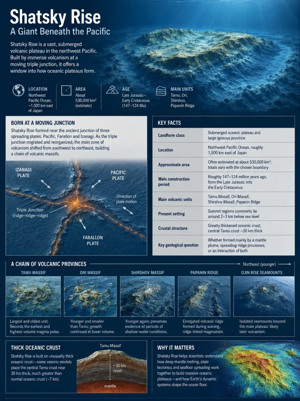
Shatsky Rise is a vast submarine volcanic plateau built into the Pacific oceanic crust during the Late Jurassic and Early Cretaceous. Its geology records unusually close interaction between enormous basaltic magma production, seafloor spreading, and the migrating triple junction where the Pacific, Izanagi, and Farallon plates once met. Magnetic surveys, seismic imaging, and scientific drilling now show that its construction was more closely tied to spreading ridges than the older image of a group of giant conventional shield volcanoes suggested.
Length
Typical width
Area using a crustal-thickness boundary
Crustal thickness beneath central Tamu Massif
A Plateau Built Into the Oceanic Crust
Shatsky Rise lies in the northwestern Pacific east of Japan, where the surrounding abyssal seafloor is generally about 5,000–6,000 meters below sea level. The rise stands several kilometers above this deep-ocean floor, but its most important geological feature is hidden below the seabed: the oceanic crust itself becomes exceptionally thick beneath the plateau.
Normal oceanic crust is commonly about 7 kilometers thick. Beneath central Tamu Massif, seismic work indicates crust approaching 30 kilometers in thickness. Shatsky Rise is therefore not simply a volcanic mountain sitting on otherwise normal crust. Much of the plateau consists of an unusually thick igneous crustal body created by exceptional magma production.
This is why Shatsky Rise is classified as an oceanic large igneous province, or oceanic LIP. Its basaltic construction involved magma volumes far beyond those of ordinary isolated seamounts.
Why Published Area Figures Differ
Shatsky Rise has no coastline that provides an obvious boundary. Older outlines based mainly on bathymetric relief produced areas around 480,000 km². A later reconstruction that traced where crustal thickness returned to approximately normal oceanic values produced an area of about 533,000 km² and an estimated crustal volume of about 6.9 million km³, excluding the sediment cover. The difference reflects boundary definition rather than a change in the physical plateau.
Tamu, Ori, Shirshov, and the Northeastward Decline in Volcanism
Shatsky Rise is elongated from southwest to northeast. Its internal arrangement is not random: the largest volcanic construction lies at the southwestern end, followed by progressively smaller structures toward the northeast. This pattern preserves an important part of the plateau’s formation history.
| Structure | Position | Approximate Form | Geological Role |
|---|---|---|---|
| Tamu Massif | Southwestern end | Enormous, broad, low-sloping edifice; roughly 315,000 km² by one bathymetric estimate | Oldest and largest main construction; records the strongest initial magmatic pulse |
| Ori Massif | Northeast of Tamu | Subrounded edifice roughly 250–300 km across | Younger and smaller phase of plateau-building volcanism |
| Shirshov Massif | Northeast of Ori | Smaller, elongated volcanic construction with a long axis of roughly 250 km | Continues the northeastward-younging and declining-volume trend |
| Papanin Ridge | Northern to northeastern continuation | Long, much lower volcanic ridge | Represents prolonged but substantially lower-flux volcanism after the major massif-building phase |
Tamu is separated from Ori by the roughly 100-kilometer-wide Helios Basin. Farther northeast, deeper basin areas separate the major volcanic constructions. The change from the immense Tamu Massif to smaller Ori and Shirshov massifs and then to the lower Papanin Ridge indicates that magma output declined as the volcanic system developed northeastward.
The sequence also becomes younger in the same general direction. A radiometric age of 144.6 ± 0.8 million years from Site 1213 on Tamu Massif confirms Late Jurassic construction there. Magnetic data indicate that younger volcanism continued northeastward through the Early Cretaceous, with Papanin Ridge extending the history well beyond the main Tamu–Ori–Shirshov building interval.
Formation Followed a Moving Triple Junction
Shatsky Rise formed in an exceptional plate-tectonic setting. During its main construction, the young Pacific Plate met the Izanagi and Farallon plates at a ridge–ridge–ridge triple junction: three spreading boundaries intersected in the same region.
The triple junction did not remain fixed. Reconstructions from marine magnetic anomalies show major changes in spreading direction, ridge orientation, and junction position around the time Shatsky Rise began to form. One major reorganization included an eastward relocation of the junction by roughly 800 kilometers. Subsequent ridge and triple-junction jumps repeatedly shifted the locus of seafloor creation.
The plateau grew along this changing plate-boundary system. Tamu, Ori, Shirshov, and Papanin can therefore be read partly as a geological trail left by a migrating and repeatedly reorganizing spreading environment.
Pacific, Izanagi, and Farallon spreading systems reorganized near the Jurassic–Cretaceous boundary.
Exceptionally high magma supply produced the largest and thickest part of Shatsky Rise.
Ridge geometry and the triple junction shifted while new oceanic crust continued to form.
Younger, smaller volcanic constructions developed farther northeast.
Lower-flux volcanism continued after the largest plateau-building pulses had waned.
High-resolution bathymetry adds another line of evidence. Subdued troughs divide parts of Tamu Massif into broad segments, a geometry consistent with construction through a succession of major eruptive centers associated with a jumping triple junction rather than growth from one permanent central vent.
Magnetic Stripes Preserve an Unusually Detailed Construction Record
Marine magnetic anomalies are unusually informative at Shatsky Rise. New oceanic crust records the polarity of Earth’s magnetic field as basalt cools. When the geomagnetic field reverses, later crust records the opposite polarity, producing alternating magnetic bands that can be matched with the geomagnetic reversal timescale.
Many enormous Pacific oceanic plateaus formed during long intervals when Earth’s magnetic field did not reverse frequently. Shatsky Rise began earlier, around the Jurassic–Cretaceous boundary, when reversals were still occurring often enough to leave a much more detailed sequence of magnetic lineations.
These lineations occur not only around Shatsky Rise but across major parts of the plateau itself. They record seafloor spreading through and beneath the volcanic constructions. Their orientations also change between different parts of the rise, revealing ridge rotation, reorganized spreading directions, and complicated triple-junction motion.
Tamu Massif contains predominantly linear and curving magnetic anomalies. Ori also preserves spreading-related lineations, while more complicated patterns around Shirshov have been interpreted as evidence for unusually complex plate-boundary behavior, potentially including short-lived microplate development.
What the Magnetic Stripes Actually Show
Magnetic lineations are strong evidence about how the crust was assembled. They show that spreading-ridge processes operated during construction. By themselves, however, they do not identify the ultimate mantle source of the unusually large magma supply.
Why Tamu Massif Is No Longer Safely Described as Earth’s Largest Single Volcano
Tamu Massif became widely known after a 2013 interpretation described it as one immense shield volcano. Seismic profiles showed long basaltic flows extending away from the massif’s central region, while its extraordinary width and very gentle slopes resembled an enormous submarine shield. Under that model, Tamu was presented as a candidate for the largest single volcano on Earth.
More detailed magnetic mapping later changed the interpretation. A conventional shield volcano is expected to grow mainly by eruptions centered on a volcanic plumbing system. Tamu instead contains broad sets of linear magnetic anomalies produced by crust of alternating magnetic polarity. That geometry is characteristic of crust formed while seafloor spreading was active.
The newer model interprets Tamu as an immense volcanic massif created largely through voluminous, focused volcanism along spreading ridges. The basaltic construction remains extraordinary in size; what changed is the model of how that construction was assembled.
Classification Caution
“Earth’s largest volcano” reflects an influential earlier interpretation of Tamu Massif, not an uncontested modern classification. “Largest and oldest main volcanic edifice of Shatsky Rise” is a more defensible description when discussing its present geological interpretation.
Ridge Tectonics and the Mantle-Plume Question Are Not the Same Problem
The recognition of spreading-related construction does not completely settle why so much magma was available. Two different questions need to be separated: what controlled where the magma erupted, and what produced the abnormal quantity of melt in the mantle.
Ridge and triple-junction control is strongly supported by the geometry of the magnetic anomalies, the age of the volcanic crust, the alignment of the main massifs, and evidence that Shatsky Rise formed on very young lithosphere close to active spreading centers. These observations explain much of the emplacement pattern.
A mantle plume has long been proposed to explain the unusually high magma supply, especially the enormous initial construction of Tamu Massif followed by a decline in volcanic output toward the northeast. Some geochemical observations have also been interpreted as compatible with a mantle source different from ordinary mid-ocean-ridge melting.
Yet plume activity and ridge tectonics are not mutually exclusive. If anomalously hot or fertile mantle was present beneath the region, the thin lithosphere and complex geometry around the young Pacific Plate could have promoted extensive decompression melting and focused that magma toward spreading boundaries.
| Observation | What It Supports | What It Does Not Prove |
|---|---|---|
| Linear magnetic anomalies within the massifs | Crust was assembled through active seafloor-spreading processes | The thermal or chemical origin of the excess mantle melt |
| Formation along a triple-junction trace | Strong plate-boundary control on emplacement | That ridge geometry alone supplied all of the excess magma |
| Very thick crust beneath Tamu | Exceptionally large mantle melting and magma delivery | A unique distinction between plume and non-plume sources |
| Declining volcanic volume toward the northeast | A major initial pulse followed by waning magma production | A single required mechanism for that decline |
| Young, thin lithosphere at emplacement | Conditions favorable for extensive decompression melting | The absence of deeper mantle influence |
The best-supported interpretation is therefore more specific than simply choosing “plume” or “ridge.” Spreading ridges and triple-junction tectonics strongly controlled the geometry and emplacement of Shatsky Rise. Whether a deep mantle plume, another mantle thermal or compositional anomaly, or a combination of processes supplied the excess melt remains less firmly resolved.
The Crust Beneath Tamu Is Several Times Normal Oceanic Thickness
Seismic reflection and refraction data reveal a crustal structure unlike the surrounding Pacific basin. Away from the rise, the transition from crust to mantle occurs beneath an oceanic crust roughly 7 kilometers thick. Moving beneath Shatsky Rise, the crust-mantle boundary—the Mohorovičić discontinuity, or Moho—deepens substantially.
Central Tamu Massif reaches an estimated crustal thickness of about 30 kilometers. Thickened crust also extends through areas between the main volcanic highs, although not everywhere to the same degree. This hidden igneous mass explains why tracing the plateau only by its visible bathymetric relief can underestimate its geological footprint.
Several kilometers of water cover the modern plateau.
Pelagic ooze, chalk, limestone, chert, and other sediments accumulated after the main volcanic construction.
Pillow lavas, sheet flows, volcaniclastic material, and altered basalt record submarine eruption.
Large intrusive and extrusive magma volumes build a crustal section far thicker than normal abyssal crust.
The crust-mantle boundary is displaced downward beneath the thickest parts of the rise.
Schematic vertical relationship only; the layers are not shown to scale.
The thick crust also affects isostasy. A large, relatively low-density crustal body floats higher on the mantle than ordinary thin oceanic crust, helping explain why the newly formed plateau initially stood much closer to sea level than its present depth might suggest.
Drilling Reveals How the Basaltic Plateau Erupted
Scientific drilling has recovered volcanic basement from several locations on Shatsky Rise. The rocks confirm that the plateau is dominated by basaltic magmatism rather than by a thick pile of felsic or continental-type crust.
At Site U1347 on Tamu Massif, drilling recovered stacked tholeiitic basalt units that include both pillow structures and massive sheet flows. Pillow lava forms when basalt erupts directly into water and its exterior chills rapidly. Sheet flows represent more extensive outpourings capable of spreading large volumes of lava across the seafloor.
Individual massive flows recovered from Tamu can be many meters thick. Their presence fits the high-effusion eruptive environment required to build such an enormous volcanic construction. Altered basalt, hyaloclastite, volcaniclastic deposits, veins, and sediment interbeds record interaction among hot lava, seawater, erosion, hydrothermal alteration, and pauses between eruptions.
The Eruptive Environment Changed Across the Plateau
Shatsky Rise was not constructed at a single uniform water depth. Some drilled sites preserve evidence of normal submarine volcanism, while other summit locations indicate eruption in very shallow water or potentially above sea level.
Highly vesicular basalt recovered at some sites requires pressure low enough for dissolved gases to escape efficiently. Shallow-water sedimentary deposits immediately above volcanic basement provide independent evidence that parts of the volcanic surface were close to sea level. Benthic microfossils from basal sediments at some drill sites also indicate water depths measured in hundreds rather than thousands of meters.
Parts of Shatsky Rise May Once Have Emerged Above the Pacific
Today, even the elevated parts of Shatsky Rise are deeply submerged, but drilling and seismic evidence indicate a very different landscape shortly after emplacement. Flat-topped basement surfaces on some massifs are consistent with erosion near sea level, and several drill sites preserve shallow-marine deposits immediately above the basaltic basement.
At some locations, eruption depths have been interpreted as less than a few hundred meters. Evidence from vesicular lavas, shallow-water sediments, erosion, and altered volcanic material leaves open the possibility that volcanic summits temporarily formed islands or low emergent land before subsiding.
During Early Plateau Development
- Exceptionally thick, buoyant young crust
- Volcanic summits close to sea level
- Shallow-marine eruptions at several sampled locations
- Possible local subaerial exposure and erosion
Modern Shatsky Rise
- Old, cooled Pacific lithosphere
- Main summits now kilometers below sea level
- Thick sediment cover over parts of the volcanic basement
- Original volcanic surfaces modified by erosion and mass wasting
Calculated post-eruption subsidence at several Expedition 324 basement sites is roughly 3.2–3.4 kilometers. Much of this change can be explained by ordinary thermal subsidence: newly formed oceanic lithosphere cools, contracts, becomes denser, and sinks progressively deeper as it ages.
Minerals from Tamu Record a Two-Level Magma Plumbing System
Mineral chemistry from Tamu Massif provides a more detailed view of what happened between mantle melting and eruption. Recent work on clinopyroxene and plagioclase from Ocean Drilling Program Site 1213 modeled a two-stage crustal magma system rather than simple uninterrupted ascent from the mantle to the seabed.
Mineral compositions indicate crystallization at roughly 25 km depth, with modeled temperatures above about 1,220°C.
A second environment is modeled near 7 km depth at temperatures around 1,140°C, where magma continued to evolve before eruption.
Diffusion chronometry suggests final transport from the shallow system to seafloor eruption commonly occurred within only a few days.
The modeled final transport interval is approximately 6.27 to 93.9 hours. These timescales resemble rapid magma transfer associated with fast-spreading ridge systems, adding a petrological line of evidence consistent with the close relationship between Tamu magmatism and spreading-ridge processes.
Scope of the Magma-Plumbing Model
The depth, temperature, and transport estimates come from minerals sampled at Site 1213 on Tamu Massif. They provide a detailed model for that sampled volcanic system, but should not be treated as directly measured conditions beneath every part of Shatsky Rise.
The Plateau Continued to Change Long After the Main Eruptions
The modern shape of Shatsky Rise is not a pristine copy of its Late Jurassic and Early Cretaceous volcanic surface. After the major plateau-building eruptions declined, cooling, subsidence, sedimentation, secondary volcanism, faulting, erosion, and underwater mass movement continued to modify the rise.
Pelagic sediments accumulated across the volcanic basement as the plateau moved through the Pacific. On some high areas, the sedimentary section reaches roughly a kilometer or more in thickness. Much of this cover consists of marine carbonate and siliceous sediments deposited far from continental sources.
Later volcanic features also developed on parts of the older construction. High-resolution mapping of southern Shatsky Rise distinguishes the primary plateau-building topography from younger secondary volcanic structures and from landforms produced by sediment movement.
Broad scars, troughs, and redistributed sediment show that submarine mass wasting has altered parts of Tamu Massif. Some subdued troughs are older structural features related to its construction, while other surface forms reflect what happened after the main igneous edifice already existed. Bathymetry must therefore be interpreted together with seismic and magnetic data rather than treated as a direct map of the original eruptive surface.
What Makes Shatsky Rise Unusually Well Constrained
Most of Shatsky Rise lies beneath several kilometers of seawater and additional sediment, yet its formation history can be reconstructed from several independent records that answer different geological questions.
Seafloor Form
Multibeam Bathymetry
Maps the shape of the massifs, basins, troughs, secondary volcanic features, and younger sedimentary landforms.
Construction Direction
Marine Magnetics
Tracks polarity bands, spreading directions, ridge rotation, and movement of the triple-junction system.
Hidden Structure
Seismic Imaging
Constrains sediment thickness, volcanic basement geometry, crustal thickness, and the depth of the Moho.
Direct Samples
Ocean Drilling
Provides basalt, sediment, alteration products, microfossils, and material suitable for geochemical and chronological analysis.
Timing
Radiometric Dating
Provides numerical ages that can be compared with magnetic chrons and reconstructed plate motion.
Magma Behavior
Mineral Chemistry
Constrains crystallization conditions, magma evolution, and short-timescale movement through the crust.
The overlap of these records is particularly valuable. A magnetic anomaly may show that crust formed by spreading, seismic data can show how thick that crust became, and drilling can reveal the basalt that actually formed it. No single method provides the complete formation model.
The Emplacement Geometry Is Clearer Than the Ultimate Magma Source
Several parts of the Shatsky Rise history are now comparatively well constrained. The rise developed during Late Jurassic–Early Cretaceous seafloor spreading; its main massifs become generally younger toward the northeast; Tamu records the largest initial magmatic construction; the crust beneath the rise is abnormally thick; and spreading-ridge and triple-junction processes were directly involved in building the volcanic plateau.
The largest remaining uncertainty lies deeper. Magnetic anomalies can reveal how new crust moved away from spreading centers, but they cannot determine by themselves whether the exceptional melt supply came from a classic deep mantle plume. Geochemistry and the enormous initial magma volume allow plume influence, while the young lithosphere and unusual network of nearby spreading boundaries provide mechanisms for extensive melting even without treating plume activity as the sole control.
The exact chronology is also less precise away from the best-sampled sites. Individual lava packages may differ in age from the underlying magnetic crust, and geomagnetic polarity timescales have been recalibrated over time. Ages assigned to particular M-anomalies therefore vary slightly among older and newer studies.
Shatsky Rise is consequently best understood as a large igneous province whose emplacement was tightly coupled to a migrating spreading-ridge triple junction, with the deeper cause of its exceptional magma supply still open to more than one geodynamic interpretation.