INTERACTIVE CONTEXT MAP
Where is Kerguelen Plateau?
The selected plateau and nearby mapped locations are shown. Open the full world atlas to explore every region.
Submarine Volcanic Plateau • Southern Indian Ocean
The Kerguelen Plateau is a vast, mostly submerged volcanic landform built through repeated eruptions, plate-boundary shifts, crustal stretching, and the burial of old Gondwanan fragments beneath thick basalt. Its present geography records several different geological histories rather than one simple volcanic event.
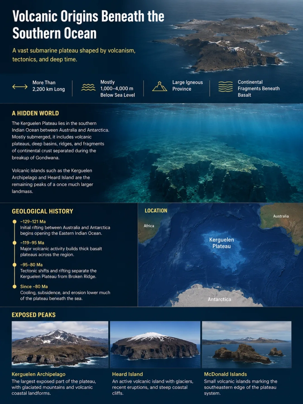
The Kerguelen Plateau lies between Australia and Antarctica in the southern Indian Ocean. It is commonly described as one of Earth’s largest submarine plateaus, yet the label hides a more complicated structure. The plateau includes old lava provinces, fault-bounded ridges, deep sedimentary basins, former land surfaces, active volcanic islands, and fragments of continental crust that were separated during the breakup of Gondwana.
Most of the plateau is now underwater, but parts of it once stood above sea level long enough to develop rivers, soils, vegetation, and forests. Later cooling, rifting, erosion, and subsidence lowered much of the landform beneath the ocean. The Kerguelen Archipelago, Heard Island, and the McDonald Islands remain as small surface exposures of a much larger submerged system.
| Profile Field | Kerguelen Plateau |
|---|---|
| Location | Southern Indian Ocean, between Australia and Antarctica |
| Plate Setting | Main plateau on the Antarctic Plate; related Broken Ridge lies on the Australian Plate |
| Length | More than 2,200 km from northwest to southeast |
| Approximate Area | Published estimates vary from more than 1 million km² to about 2.2 million km², depending on the mapped boundary and inclusion of associated domains |
| Typical Water Depth | Much of the plateau lies about 1,000–4,000 m below sea level |
| Landform Type | Submarine volcanic plateau and large igneous province with mixed magmatic and continental crust |
| Main Physiographic Divisions | Northern, Central, and Southern Kerguelen Plateau; Elan Bank; William’s Ridge; adjoining Labuan Basin |
| Exposed Parts | Kerguelen Archipelago, Heard Island, and McDonald Islands |
| Main Construction Age | Much of the volcanic basement formed about 119–95 million years ago, followed by younger volcanic episodes |
Data Note
Area figures differ because researchers do not always draw the outer boundary in the same place. Some measurements focus on the main plateau, while others include connected volcanic domains or reconstructed fragments. Length and water-depth ranges are more consistently reported than one exact area.
Map Note
The map provides geographic orientation rather than a scientific boundary. The plateau is a submerged region with margins defined from bathymetry, gravity, magnetic data, seismic profiles, and geological sampling rather than coastlines visible on a normal road map.
A Submerged Plateau Made of Ridges, Banks, and Basins
The Kerguelen Plateau is not a flat slab on the ocean floor. Its relief includes broad volcanic surfaces, raised banks, steep escarpments, elongated ridges, faulted troughs, and sediment-filled depressions. Some high areas rise to within a few hundred metres of sea level, while nearby basins descend into much deeper water.
The main plateau extends northwest–southeast across the southern Indian Ocean. Its western and central sections contain the best-known volcanic provinces, while the eastern side grades toward William’s Ridge and the Labuan Basin. Farther north, Broken Ridge preserves a separated part of the former Kerguelen–Broken Ridge system.
This uneven seafloor explains why the plateau cannot be assigned one modern elevation. A continental plateau can be described by its height above sea level, but a submarine plateau requires several measurements: water depth above the surface, relief above the surrounding abyssal plain, crustal thickness, and the depth of buried volcanic basement beneath sediment.
The Northern, Central, and Southern Provinces
Geologists divide the landform into broad provinces because the northern, central, and southern sectors do not share the same age or volcanic history. The divisions are useful, but their boundaries are geological zones rather than sharp lines.
| Province | Typical Geological Record | Distinctive Features |
|---|---|---|
| Northern Kerguelen Plateau | Large areas formed during Oligocene–Miocene volcanism, although older Cretaceous rocks occur beneath or within the province | Kerguelen Archipelago, younger volcanic centres, mixed basaltic and evolved volcanic rocks |
| Central Kerguelen Plateau | Cretaceous volcanic basement with later intrusive and extrusive activity | Kerguelen–Heard Basin, Heard Island, McDonald Islands, William’s Ridge |
| Southern Kerguelen Plateau | Mainly Early Cretaceous volcanic basement, commonly dated near 119–110 million years | Raggatt Basin, Elan Bank, large graben systems, thick volcanic crust |
The northward shift in the age of exposed or drilled volcanic rocks helps show that the Kerguelen system developed in episodes. It also reflects the movement of tectonic plates relative to a long-lived mantle melting region and to spreading ridges that repeatedly changed position.
Why Kerguelen Is a Large Igneous Province Rather Than One Volcano
A single volcano grows around one main vent or vent complex. The Kerguelen Plateau formed across an area too large, too old, and too varied to fit that model. It belongs to a large igneous province, a region where very large volumes of magma reached or entered the crust over broad areas.
Much of the plateau consists of basalt, but the volcanic pile also contains intrusive bodies, dipping lava sequences, volcanic sediments, and more evolved rocks such as trachyte and rhyolite in some provinces. The magma did not erupt from one central cone. It moved through many fissures and volcanic centres during separate tectonic episodes.
Mantle Melting Increased
Hot mantle material and decompression produced unusually large amounts of magma beneath the opening Indian Ocean region.
Basalt Spread Across a Broad Area
Repeated lava flows and intrusions thickened the crust instead of forming only one isolated volcanic mountain.
Ridges and Continental Fragments Interacted
Changing spreading centres placed magma beside or beneath stretched Gondwanan crust, creating a mixed foundation.
Later Volcanism Added New Surface Features
Younger eruptions built the Kerguelen Archipelago, Heard Island, and McDonald volcanic centres long after the main Cretaceous plateau formed.
The Main Cretaceous Construction Phase
Scientific drilling indicates that much of the plateau’s magmatic crust formed during the Cretaceous, especially between about 119 and 95 million years ago. Southern Kerguelen preserves some of the older upper-basement ages, while parts of Central Kerguelen record younger Cretaceous construction.
The age pattern is not a neat northward conveyor belt. Magmatism moved, stopped, restarted, and interacted with spreading ridges. Some late volcanic activity also occurred along margins that were being stretched. This produces overlapping ages rather than a single line of progressively younger volcanoes.
Plume–Ridge Interaction
The Kerguelen system is often linked to a mantle plume or long-lived hotspot. That model explains the large magma supply, but the plateau also formed near moving plate boundaries. When the spreading ridge approached the melting region, magma could reach the crust along zones already weakened by extension.
This interaction helps explain why the Kerguelen record includes both hotspot-like lava and features associated with rifting or ocean-ridge activity. It also explains why volcanic construction and crustal breakup did not always happen at the same time.
Continental Fragments Hidden Beneath the Basalt
Early interpretations treated the plateau mainly as thickened oceanic crust. Ocean drilling, dredging, seismic surveys, and isotope studies later showed that this description was incomplete. Parts of the plateau contain continental basement or continental material beneath the volcanic cover.
The present model is a crustal mosaic. Some domains are dominated by magma formed in an oceanic setting. Others contain old Gondwanan rock that was stretched, separated, and covered by basalt. These pieces can be difficult to detect because younger lava and sediment hide the original basement.
Elan Bank and the First Clear Continental Evidence
Elan Bank projects westward from the boundary between the central and southern plateau. Drilling at Ocean Drilling Program Site 1137 recovered gneissic metamorphic and felsic igneous clasts from a volcaniclastic conglomerate deposited by flowing water. Those rock types are not normal products of a purely oceanic basaltic plateau.
The evidence supports Elan Bank as a microcontinental fragment that once lay between India and Antarctica within Gondwana. Later rifting and a change in spreading-ridge position transferred the fragment between plate systems. Thick Cretaceous volcanism then altered and buried much of its older continental structure.
William’s Ridge and Rig Seismic Seamount
Research published in 2025 identified William’s Ridge and Rig Seismic Seamount as two additional microcontinents in the eastern Kerguelen region. The interpretation is based on rocks dredged during an RV Investigator voyage and tested with petrography, whole-rock chemistry, and several radiometric dating methods.
William’s Ridge yielded ancient amphibolitic–granitic gneiss and metavolcanic basement. Their ages and geological character were linked to the Shillong Plateau region of northeastern India. Rig Seismic Seamount contained much older Archean and Proterozoic rocks, together with younger granite, that may connect it to the Vestfold Craton of East Antarctica.
The two sites do not point to one uniform buried continent. They suggest that rifting broke a continental margin into several ribbons and blocks. Some fragments may have come from Greater India, while others retained stronger ties to East Antarctica.
Landform Note
Finding continental rock beneath parts of Kerguelen does not mean the entire plateau is a sunken continent. The landform includes continental fragments, thick magmatic crust, volcanic ridges, and oceanic domains. “Microcontinent” is more accurate for the identified blocks than a single continent-wide label.
Why Continental Material Appears in Volcanic Rocks
Continental signals can enter Kerguelen magma in more than one way. Rising melt may pass through and partly assimilate continental crust. Older continental lithosphere may also contribute material to the mantle source. In other places, lava may simply cover an intact continental fragment without fully melting it.
This makes chemical interpretation difficult. A continental isotope pattern does not always prove that a thick continental block lies directly below the sampled lava. The strongest cases combine rock samples with seismic structure, gravity patterns, crustal thickness, and plate reconstructions.
When Parts of the Plateau Stood Above Sea Level
The present water depth can make Kerguelen seem like an entirely submarine feature. Drilling records show that parts of the plateau were once exposed as land or lay in very shallow water. This condition lasted long enough for erosion, river transport, soil formation, and plant colonisation.
Evidence includes subaerial lava flows, fluvial volcaniclastic conglomerates, shallow-water sediments, wood fragments, charcoal, pollen, spores, seeds, and reworked coal. Some sediments record tree ferns followed by podocarp-dominated vegetation in a mild and wet Cretaceous climate.
A Volcanic Island Province, Not One Continuous Continent
The land probably changed through time. Broad basalt surfaces may have formed low islands or larger connected land areas during phases of rapid lava accumulation and thermal uplift. Other parts remained shallow seas, banks, or channels. Continued subsidence then separated and reduced the exposed areas.
The presence of forests does not prove that every part of the plateau stood above water at once. Drill cores sample specific points, and each point records only its local environment. The safest reconstruction is a changing province of volcanic land, shallow shelves, river-fed deposits, and marine basins.
Geography Note
The plateau has no modern river network because almost all of it is submerged. River evidence refers mainly to Cretaceous land surfaces and fluvial sediments. The exposed islands have short streams, meltwater channels, and glacial drainage, but these do not represent a plateau-wide drainage system.
How Long Did Emergent Conditions Last?
Geological sampling suggests that parts of the plateau remained emergent or in shallow water for as much as about 40 million years. The timing differed by province. Some areas subsided below sea level earlier, while volcanic renewal kept other areas elevated or created new islands.
As the surface lowered, terrestrial sediments were covered by marine shale, carbonate deposits, and later deep-water ooze. This vertical sequence records a change from land and shoreline environments to an open-ocean setting.
Broken Ridge and the Long, Uneven Breakup of the Plateau
Broken Ridge now lies far north of the Kerguelen Plateau on the Australian Plate. Matching geometry, volcanic rocks, stratigraphy, and plate reconstructions show that it was once joined to the Central Kerguelen region, including the margin near William’s Ridge.
Seafloor spreading along the Southeast Indian Ridge eventually separated the two. New oceanic crust formed between them, carrying Broken Ridge northward relative to the plateau. The breakup developed through several stages and propagated across the former connected province rather than opening everywhere at the same moment.
Why Final Separation Came Late
Large igneous provinces often begin to fragment during or soon after their main volcanic construction. Kerguelen behaved differently. Research published in 2026 describes an interval of roughly 45 million years between major emplacement and final breakup along the William’s Ridge–Broken Ridge margin.
Dredged volcanic rocks from the conjugate margins record renewed melting about 82–67 million years ago. Their chemistry points to plume–ridge interaction with limited assimilation of continental crust. Extension and magma movement became focused along the weaker edge of the William’s Ridge microcontinent.
Earlier stretching prepared the margin without fully separating it. A later ridge jump near 44 million years ago completed the breakup. The sequence shows how an old microcontinent boundary can guide deformation long after the main flood-basalt phase has ended.
Common Mix-Up
The breakup of Kerguelen and Broken Ridge was not the same event as the first formation of the plateau. Most plateau basalt is Cretaceous, while final separation along the modern ridge system occurred much later, mainly during the Eocene.
Rift Systems and Sedimentary Basins Within the Plateau
The plateau contains internal faults and basins as well as broken outer margins. These features show that the crust continued to stretch and sag after volcanic construction. They also preserve sediments that record subsidence, ocean currents, biological growth, and changing water depth.
The 77° Graben and Other Southern Rift Zones
The 77° Graben extends north–south for more than 400 km across the Southern Kerguelen Plateau. It is a fault-bounded depression formed when the crust stretched and the central block dropped. Geological interpretation places its main development near the latest Cretaceous, though some bordering faults moved again during later periods.
Farther south, the 59° Graben trends roughly east–west, while the Southern Kerguelen Plateau rift zone follows a northwest–southeast direction. Their different orientations record changes in the direction and location of crustal stress. They also show why the plateau should not be treated as one rigid, unbroken block.
Kerguelen–Heard Basin
The Kerguelen–Heard Basin occupies part of the central province. It is a broad sag basin with more than 2,000 m of Cenozoic sediment in places and an area greater than about 40,000 km². Later bottom currents reworked some of the upper sedimentary layers, creating structures unrelated to the original volcanic basement.
Raggatt Basin
The Raggatt Basin lies in the southern province and covers roughly 58,000 km². It contains at least 2,000 m of Cenozoic sediment, with older layers below. Seismic profiles show a buried igneous ridge beneath its eastern side and dipping reflections interpreted as thick lava sequences.
Some carbonate mounds within the basin formed through biological growth rather than renewed volcanism. Their presence matters because rounded or mound-like forms in seismic data can otherwise be mistaken for volcanic cones.
Labuan Basin and William’s Ridge
The Labuan Basin borders the plateau’s eastern side. It is about 1,000 km long and roughly 250 km wide, with several kilometres of sediment in places. Its basement varies from faulted crust near the plateau to smoother and less clearly understood domains farther east.
William’s Ridge rises along this complex eastern margin. Older surveys estimated crust about 12–15 km thick beneath the ridge, much thicker than normal nearby basin crust. New continental rock samples now support the view that its unusual thickness is linked partly to a buried microcontinental foundation.
Why Most of Kerguelen Became Submerged
No single event lowered the entire plateau. Submergence developed through several processes acting at different rates and in different provinces.
Cooling and Thermal Subsidence
Freshly formed volcanic crust is hot and buoyant. As it cools, it contracts and becomes denser. The seafloor then lowers through thermal subsidence. This process can continue for tens of millions of years after the main eruptions have stopped.
Crustal Stretching and Faulting
Rifting thinned parts of the plateau and created grabens, basins, and fault-bounded blocks. Thinned crust sits lower than thick crust, especially after it cools. This produced uneven submergence: ridges and banks remained shallow while nearby basins sank farther.
Weight of Lava and Sediment
Large lava piles add mass to the crust. Later sediment also loads the surface, especially within sag basins. The lithosphere responds by bending and adjusting toward isostatic balance. Loading did not act alone, but it added to the long-term lowering of some domains.
Erosion and Changing Sea Level
Exposed volcanic land was weathered and eroded. Rivers carried debris into low areas, while waves cut shorelines and redistributed sediment. Global sea-level changes repeatedly shifted the coastline, but they were too small to explain the present depth of most of the plateau. Deep submergence mainly reflects crustal and thermal processes.
Landform Note
Kerguelen did not “sink” like a rigid raft. Different blocks cooled, stretched, eroded, and subsided at different times. Some later received new volcanic material, which raised local islands without lifting the whole plateau.
The Islands as Surface Windows Into Different Geological Ages
The islands above Kerguelen are not identical remnants of one old surface. They expose younger volcanic systems built on top of the submerged plateau and provide access to only a small part of its full geological record.
Kerguelen Archipelago
The Kerguelen Archipelago rises from the northern province. Much of its visible volcanic history is younger than the main Cretaceous plateau, with extensive activity during the Cenozoic. Basalt dominates, but differentiated magmas produced trachytic and other evolved rocks in some centres.
The archipelago therefore represents renewed volcanism above an older and more complicated basement. Its exposed rocks cannot be used as a simple sample of the entire plateau.
Heard Island
Heard Island stands on the Central Kerguelen Plateau. Its main volcanic mass, Big Ben, rises to Mawson Peak at about 2,745 m above sea level. Ice, snow, lava, and rapid erosion interact on the island, creating a surface very different from the broad Cretaceous lava plains preserved beneath the ocean.
Heard remains active. Satellite data recorded an eruption from 24 to 25 June 2026, including ash plumes that reached about 11 km above sea level. This modern activity belongs to a young volcanic centre; it does not mean the whole submarine plateau is presently erupting.
McDonald Islands
The McDonald Islands lie west of Heard Island and have also experienced recent volcanic activity. Eruptions during the late twentieth and early twenty-first centuries changed the islands’ shape, increased their elevation, and joined or enlarged parts of the land area.
The lava chemistry includes phonolitic compositions, showing that Kerguelen magmatism is not limited to simple basalt. Magma can remain, evolve, and separate into more silica- or alkali-rich compositions before eruption.
How a Plateau Under Deep Water Is Reconstructed
Most of Kerguelen cannot be studied by walking across an outcrop. Its geography is reconstructed by combining methods that measure shape, buried layers, crustal thickness, rock age, and chemical origin.
Seafloor Shape
Multibeam Bathymetry
Ship-based sonar maps ridges, escarpments, grabens, volcanic cones, channels, and basin floors in far more detail than normal ocean maps.
Buried Structure
Seismic Reflection
Sound waves reveal sediment layers, faults, buried volcanic surfaces, dipping lava sequences, and the depth of basement below the seafloor.
Crustal Character
Gravity and Magnetic Data
Regional anomalies help identify thick crust, volcanic bodies, faulted domains, and areas that may contain less magnetic continental rock.
Direct Samples
Scientific Drilling
Drill cores recover basalt, sediment, fossils, coal, wood, and continental clasts while preserving their vertical geological order.
Exposed Slopes
Dredging
Rock baskets collect material from steep submarine escarpments where older basement may be exposed beneath younger lava or sediment.
Age and Origin
Geochronology and Isotopes
Mineral ages and isotope ratios connect rocks to volcanic episodes, continental terranes, mantle sources, and episodes of crustal contamination.
Why One Method Is Not Enough
A dredged gneiss may prove that continental rock exists at one escarpment, but it does not map the size of the buried block. Seismic data may show thick crust, but thickness alone cannot identify whether the crust is volcanic, continental, or mixed. Chemical signals can reveal contamination without locating the contaminating material.
The strongest interpretations appear where several methods agree. Elan Bank combines drilled continental clasts with seismic structure and plate reconstruction. William’s Ridge combines thick crust, mapped escarpments, dredged ancient rocks, mineral ages, and conjugate-margin geometry with Broken Ridge.
Geological Timeline of the Kerguelen Plateau
Gondwana Breakup and Early Magmatism
Mantle melting increased as India, Antarctica, and Australia entered a changing rift system. Early Kerguelen-related volcanic rocks formed across the wider Indian Ocean region.
Main Plateau Construction
Large volumes of basalt built much of the Southern and Central Kerguelen Plateau. Some volcanic surfaces rose above sea level.
Continental Fragments Were Isolated
Spreading-ridge shifts and rapid plate motion separated pieces of Gondwanan crust, including the fragments now identified at Elan Bank, William’s Ridge, and Rig Seismic Seamount.
Land, Rivers, Forests, and Renewed Extension
Some plateau surfaces supported terrestrial environments. Other parts developed grabens, basins, and renewed volcanic activity along stretched margins.
William’s Ridge and Broken Ridge Separated
A ridge jump and seafloor spreading completed breakup along a margin that had already experienced earlier extension and volcanism.
Northern and Central Volcanism Continued
Younger volcanic episodes built or modified parts of the northern plateau and added intrusive and extrusive rocks around the central province.
Active Island Volcanoes
Heard and McDonald volcanic centres remained active while most of the older plateau stayed deeply submerged.
Satellite-Detected Heard Eruption
An ash-producing eruption at Heard Island showed that young volcanism continues above the Central Kerguelen Plateau.
What Remains Uncertain Beneath Kerguelen
The Full Extent of Continental Crust
Continental rocks are confirmed at several locations, but large areas remain unsampled. Researchers still need to determine whether the known fragments are isolated blocks, parts of longer ribbons, or connected beneath younger volcanic crust.
The Southernmost Plateau Boundary
Not every raised area south of the main plateau has the same origin. New seismic work indicates that some southernmost domains may have a more oceanic structure than nearby continental fragments. This prevents one crustal label from being applied across the entire southern margin.
The Position and Shape of the Mantle Melting Region
The long volcanic record is usually linked to the Kerguelen plume, yet the depth, shape, and movement of the melting system remain debated. Plate motion, spreading-ridge relocation, and continental lithosphere all altered where magma formed and how it reached the crust.
The Timing of Submergence in Each Province
There is no single date when “Kerguelen sank.” Drill sites show local transitions from land to shallow sea and then deeper water, but each site followed its own path. More cores and higher-resolution seismic mapping are needed to reconstruct changing coastlines across the full plateau.
The Links Between Separate Microcontinents
Age matches connect William’s Ridge with northeastern India and Rig Seismic Seamount with East Antarctica, but those correlations require more samples. Future work must test whether Central Kerguelen and William’s Ridge once formed one fragment, and whether the southern plateau and Rig Seismic Seamount shared a longer continental strip before breakup.