Southern Utah High Plateau
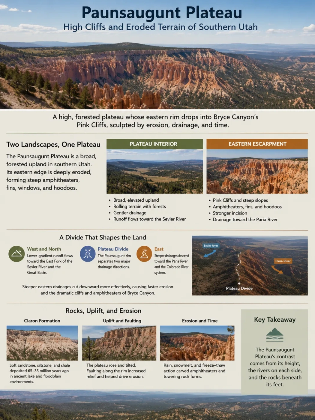
The Paunsaugunt Plateau is a high, forested upland in southern Utah whose eastern edge has been cut into the Pink Cliffs, steep amphitheaters, fins, windows and hoodoos associated with Bryce Canyon. Its defining geography comes from the contrast between a comparatively gentle plateau surface and an eastern escarpment where steeper drainage, layered sedimentary rock, faulting and active erosion work together.
Pink Cliffs eastern rim
Sevier–Paria drainage divide
A High Plateau with Two Very Different Faces
The Paunsaugunt Plateau lies in southern Utah near the southwestern margin of the wider Colorado Plateau region. Together with the Markagunt Plateau to the west, it forms part of the southern end of the High Plateaus of Utah. Much of its upper surface is a rolling, forested upland rather than a continuous field of bare cliffs.
The best-known landscape appears along the eastern escarpment. Bryce Canyon National Park occupies this eroded rim, where the plateau drops toward the Paria River basin. Here the same high surface that remains relatively subdued farther west has been cut into steep-walled amphitheaters and narrow rock forms.
Plateau Interior
- Broad, elevated upland
- Rolling hollows, low ridges and forest
- Generally gentler drainage gradients
- Much of the runoff moves toward the Sevier River system
Eastern Escarpment
- Pink Cliffs and steep slopes
- Bowl-shaped erosional amphitheaters
- Fins, windows and hoodoos
- Stronger incision toward the Paria River system
Landform Distinction
Bryce Canyon is not another name for the Paunsaugunt Plateau. The national park protects part of the plateau’s strongly eroded eastern margin, while the plateau itself extends across a much broader upland surface.
Why the Eastern Rim Erodes Faster
The sharp difference between the plateau top and its eastern edge is closely tied to drainage. The rim separates two river systems with very different gradients.
West and north of the divide, much of the plateau surface drains toward the East Fork of the Sevier River. This side has comparatively low-gradient drainage, allowing more of the rolling upland surface to survive. East of the divide, short drainages descend much more steeply toward the Paria River, a tributary of the Colorado River.
The greater drop toward the Paria gives runoff more ability to cut downward and remove material from the plateau margin. Over time, this difference promotes faster headward erosion on the eastern side and helps explain why deep amphitheaters occur there rather than uniformly across the plateau.
Lower-gradient runoff moves toward the East Fork of the Sevier River and ultimately the Great Basin.
The Paunsaugunt rim separates two major drainage directions.
Steeper drainages descend toward the Paria River and then the Colorado River.
This means the eastern rim is more than a line of cliffs. It is also part of a watershed boundary between the internally drained Great Basin and the Colorado River system.
The Claron Formation Gives the Pink Cliffs Their Shape
The famous eastern rim is developed largely in the Claron Formation, a sequence of Paleocene-to-Eocene sedimentary rocks deposited roughly 65 to 35 million years ago. Much of the material accumulated when the region was far lower than it is today and contained lake, floodplain and related freshwater environments.
The formation includes limestone-rich beds together with mudstone, sandstone and locally conglomeratic material. These layers do not weather at the same rate. More resistant beds can project outward or protect weaker rock below, while softer layers retreat faster.
Iron-bearing minerals help produce the red, orange and pink tones that distinguish the Pink Cliffs. The colors are therefore connected to the chemistry of the sedimentary rocks rather than to a separate layer painted across the landscape.
Limestone also responds to weakly acidic water. Rain and snowmelt can slowly dissolve calcium-carbonate-rich rock while physical processes widen existing fractures. The combined effect produces highly uneven weathering rather than a smooth recession of the entire cliff face.
Water enters fractures in the exposed Claron rocks while runoff removes loosened material from the rim.
Fractures widen and separate narrow walls of rock from the retreating escarpment.
Weathering breaks openings through some fins, especially where weaker zones are exposed.
When the upper part of a window fails, isolated pillars can remain temporarily before erosion removes them as well.
Hoodoos therefore represent only one stage in the retreat of the plateau edge. They are concentrated where the right combination of layered Claron rock, fractures, steep relief and weathering conditions occurs. They do not cover the Paunsaugunt Plateau as a whole.
Bryce “Canyon” Is a Set of Amphitheaters Cut into the Rim
The name Bryce Canyon can give a misleading impression of the landform. A conventional canyon is commonly organized around a river that cuts a long channel through bedrock. Bryce instead consists largely of bowl-shaped amphitheaters eroded into the eastern edge of the Paunsaugunt Plateau.
Rain and melting snow drain through these amphitheaters and eventually reach the Paria River, but there is no single large river responsible for carving the entire Bryce landscape. Headward erosion enlarges the bowls while gullies and intermittent channels carry sediment away from the retreating rim.
Name and Landform
Bryce Canyon is a geographic name, but its most characteristic landforms are erosional amphitheaters cut into a plateau escarpment rather than one continuous river-cut canyon.
The exposed Claron rocks are also part of a larger regional pattern. They form the Pink Cliffs, the uppermost major cliff step of the Grand Staircase. Similar Claron strata occur beyond Bryce Canyon, including across the Paria basin toward the Table Cliff Plateau. The hoodoo landscape is therefore a local expression of a rock unit and escarpment system that extends beyond the park boundary.
The Plateau Rises Toward the South
The Paunsaugunt surface is not perfectly level. Along the Bryce Canyon portion of the eastern rim, the land rises markedly toward the south. The southern end of the park is about 1,000 feet (304 meters) higher than the northern area near the visitor center.
Visitor Center
About 2,406 meters above sea level on the northern part of the park’s high rim area.
Rainbow and Yovimpa Points
About 2,778 meters above sea level at the southern end of the park road.
Elevation Note
The 9,115-foot figure refers to the highest viewpoints in Bryce Canyon National Park. It should not be treated as a verified maximum elevation for the entire Paunsaugunt Plateau, whose geographic boundary extends beyond the park.
The southward rise helps organize local drainage. On parts of the forested plateau, water follows the tilted surface northward before joining the Sevier system. The elevation increase also contributes to changes in vegetation along the plateau top.
Forested Upland Above, More Open Terrain Below
The eroded Pink Cliffs can make the Paunsaugunt appear dry and sparsely vegetated when viewed from the east, but the plateau top has a very different character. Large areas support forest, meadows and sagebrush communities.
Ponderosa pine is widespread across lower and middle portions of the high surface. Toward the higher southern end, mixed-conifer communities become more prominent, with fir and spruce occurring in cooler settings. Mountain meadows and sagebrush openings interrupt the forest in places.
Below the rim, declining elevation, thinner soils and more exposed slopes favor more open vegetation, including pinyon and juniper woodland. The contrast reflects both altitude and terrain: soil and moisture can persist more readily on portions of the rolling plateau surface than on rapidly eroding cliffs and steep breaks.
More open pinyon–juniper woodland and exposed erosional terrain.
Ponderosa forest, sagebrush openings and mountain meadows across rolling upland terrain.
Cooler mixed-conifer forest becomes more prominent above 9,000 feet in the Bryce area.
Freeze–Thaw Weathering Is Only Part of the Erosion Story
Freezing water is closely associated with Bryce Canyon’s hoodoos, but it does not explain the Paunsaugunt escarpment by itself. The landscape depends on several processes operating together.
Water enters fractures during rain or snowmelt. When conditions cross the freezing point, expansion of ice can widen those cracks and detach pieces of rock. At the same time, runoff transports loosened sediment downslope, weakly acidic water dissolves susceptible limestone, and gravity moves unstable blocks and slope material.
Carries weathered sediment away and cuts gullies into the retreating eastern rim.
Repeated freezing of water in fractures helps break jointed rock into smaller pieces.
Water slowly dissolves calcium-carbonate-rich layers and enlarges zones of weakness.
Rockfalls, landslides and debris movement remove material once steep slopes become unstable.
The mixture matters because a hoodoo-producing landscape requires both rock breakdown and removal of the broken material. Frost can open fractures, but runoff and mass wasting are needed to clear debris and keep the escarpment retreating.
The Eastern Rim Is Still Retreating
The Pink Cliffs are active landforms rather than remnants of a process that has ended. Rainstorms, snowmelt, rockfall, slope failure and continued weathering still modify the escarpment.
Along the actively eroding Bryce Canyon rim, commonly cited estimates place retreat at roughly 1 to 4 feet (0.3 to 1.2 meters) per century. Individual locations do not retreat evenly. A stable-looking wall may change little for years and then lose a large block during one failure.
Rate Context
The rim-retreat estimate describes the actively eroding Bryce Canyon escarpment. It is not a plateau-wide erosion rate and should not be applied to the broad forested interior of the Paunsaugunt Plateau.
Continued headward erosion also means the boundary between the Paria and Sevier drainage systems is not fixed on geologic timescales. As eastern amphitheaters expand into the plateau, they progressively remove parts of the high surface and shift the escarpment westward.
The Paunsaugunt Fault Adds Structural Control
Erosion explains the fine-scale carving of amphitheaters and hoodoos, but the plateau also has an important structural component. The Paunsaugunt fault crosses the Bryce Canyon area and locally offsets rock units and the plateau surface.
Geologic mapping has documented substantial vertical displacement along sections of the fault. This structural offset helps explain why rock layers that formed at similar times can now occur at very different elevations across relatively short distances.
New geologic-hazard work published in 2026 added an important piece of evidence. Mapping confirmed that the Paunsaugunt fault locally displaces Quaternary-age deposits, meaning movement affected deposits formed within roughly the past 2.6 million years. The findings were used to update Utah’s statewide hazardous-fault database.
Faulting and Erosion Do Different Jobs
The Paunsaugunt fault should not be described as the process that directly created the hoodoos. Fault movement offsets and fractures the landscape; differential erosion, runoff, weathering and mass wasting sculpt the exposed Claron rocks into amphitheaters, fins and isolated spires.
Why Such Rugged Terrain Still Counts as a Plateau
The cliffs and hoodoos along the eastern rim can look more like mountainous terrain than a plateau, but rugged margins do not erase the larger landform. The defining feature is the survival of a broad elevated surface above surrounding lower terrain.
On the Paunsaugunt Plateau, that surface remains visible in the rolling forested upland west of the Pink Cliffs. Drainage has cut into it, faulting has disturbed parts of it, and the eastern escarpment is moving backward, yet the larger raised block is still recognizable.
Its present form is therefore best understood as an elevated high-plateau surface with strongly dissected margins. The gentle Sevier-drained upland and the deeply eroded Paria-facing escarpment are not separate landscapes accidentally placed side by side; they are two expressions of the same plateau responding to different gradients, rock resistance, structure and rates of erosion.