INTERACTIVE CONTEXT MAP
Where is Columbia Plateau?
The selected plateau and nearby mapped locations are shown. Open the full world atlas to explore every region.
Pacific Northwest Volcanic Plateau
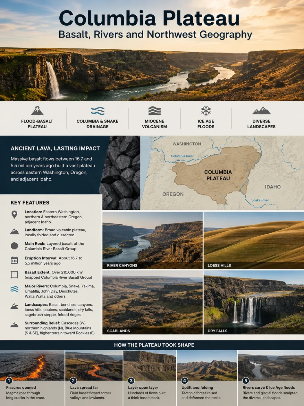
The Columbia Plateau is a broad volcanic landscape of eastern Washington, northern Oregon, and adjoining Idaho, where immense sheets of flood basalt were later folded, covered by windblown sediment, cut by major rivers, and reshaped by Ice Age floods.
The Columbia Plateau is often pictured as a flat expanse of dark lava, but its geography is much more varied. The Columbia River Basalt Group forms much of the geological foundation, while the Columbia and Snake rivers, tributary canyons, the Yakima fold ridges, Palouse loess hills, coulees, and Channeled Scablands create very different landscapes across the region.
| Feature | Columbia Plateau Profile |
|---|---|
| Location | Interior Pacific Northwest, mainly eastern Washington and northern to northeastern Oregon, with adjoining parts of western Idaho |
| Landform | Broad volcanic plateau and lava plain, locally folded and deeply dissected |
| Main Rock | Layered basalt of the Columbia River Basalt Group |
| Main Eruption Interval | About 16.7 to 5.5 million years ago for the Columbia River Basalt Group |
| Basalt Extent | More than 210,000 km² (about 81,000 sq mi) for the mapped Columbia River Basalt Group; this is not identical to the plateau’s geographic boundary |
| Major Rivers | Columbia, Snake, Yakima, Palouse, Deschutes, John Day, Umatilla, and Walla Walla |
| Characteristic Landscapes | Basalt benches, river canyons, loess hills, sagebrush steppe, coulees, scablands, dry falls, and folded ridges |
| Surrounding Relief | Cascade Range to the west, northern highlands toward the north, Blue Mountains to the south and southeast, and higher terrain toward the Rocky Mountain system to the east |
Data Note
Area figures for the Columbia Plateau vary because the physiographic province, ecological region, basalt province, drainage basin, and regional aquifer system use different boundaries. The mapped extent of Columbia River basalt should not be treated as an exact measurement of the plateau itself.
Map Note
The Columbia Plateau is a regional landform, not an administrative unit with a surveyed border. A general map is useful for orientation, but geological, ecological, and physiographic maps may draw its margins differently.
Basalt Built the Plateau in Layer After Layer
The defining rock beneath much of the plateau is basalt, a dark volcanic rock produced from relatively fluid lava. Instead of growing mainly from one cone-shaped volcano, the largest Columbia River basalt eruptions poured from long fissures near what is now the Washington-Oregon-Idaho border region.
The resulting lava could spread over very large distances. Repeated eruptions stacked flow upon flow, filling older valleys and smoothing much of the pre-existing terrain into a broad volcanic surface.
Modern geological mapping places the Columbia River Basalt Group at more than 210,000 km² in area. More than 350 lava flows are recognized in the sequence. Most of the total basalt volume erupted during a much shorter interval within the full volcanic episode, roughly between 16.7 and 15.6 million years ago.
Fissures Opened
Magma reached the surface through long cracks rather than being confined to a single central volcanic cone.
Lava Spread Across the Region
Highly fluid basalt moved through lowlands and valleys, sometimes traveling hundreds of kilometers from its vent system.
Flows Accumulated
New eruptions covered older surfaces, creating thick stacks of basalt separated in places by sedimentary layers and weathered horizons.
Erosion Exposed the Stack
Rivers and later floods cut through the lava pile, revealing repeated flows as horizontal or gently tilted bands along canyon walls.
Seven Main Basalt Formations
The Columbia River Basalt Group is divided into seven recognized formations: Steens Basalt, Imnaha Basalt, Grande Ronde Basalt, Picture Gorge Basalt, Prineville Basalt, Wanapum Basalt, and Saddle Mountains Basalt. These are further divided into members and individual flow units where geological mapping allows.
The Grande Ronde Basalt accounts for a large share of the main flood-basalt episode. Younger Wanapum and Saddle Mountains flows overlie parts of that sequence, while other formations have more limited geographic distributions.
Landform Note
A basalt plateau does not need to remain flat. Once lava solidifies, tectonic folding, river incision, weathering, sediment deposition, and catastrophic flooding can transform its surface while the basalt foundation remains clearly recognizable.
The Plateau Is Not One Uniform Lava Table
Seen at regional scale, the Columbia Plateau has a low-relief, basin-like form in many areas. On the ground, however, it alternates between rolling farmland, sagebrush plains, narrow ridges, broad valleys, steep canyon walls, basalt benches, and flood-scoured rock.
Some regional descriptions place lower parts of the plateau near 400 feet (about 120 m) above sea level and upland margins around 4,000 feet (about 1,220 m). These numbers describe a broad regional pattern rather than a fixed elevation range. Folded ridges and adjoining uplands can rise above the general plateau surface.
The surface also changes from west to east and north to south. Central Washington contains large dry basins and flood-eroded tracts. The Palouse is marked by deep windblown sediment and rolling hills. South-central Washington includes long folded ridges. Northern Oregon is crossed by river canyons that expose stacked basalt in their walls.
Rivers Reveal the Architecture of the Basalt
The rivers are among the best places to understand the Columbia Plateau because they cut below the modern land surface and expose its internal structure. Canyon walls commonly show dark basalt layers stacked one above another, sometimes separated by thinner sedimentary units.
| River | Relationship to the Plateau | Geographic Expression |
|---|---|---|
| Columbia River | The main regional river and drainage axis | Crosses and borders large parts of the plateau before passing through the Cascade Range in the Columbia River Gorge |
| Snake River | Largest major tributary joining the Columbia within the plateau region | Deeply incised valleys expose volcanic and older rock sequences east of the central Columbia Basin |
| Yakima River | Drains south-central Washington toward the Columbia | Passes through valleys and gaps associated with the Yakima fold landscape |
| Palouse River | Drains part of the loess-covered eastern plateau toward the Snake | Links rolling Palouse terrain with basalt canyons and flood-modified landscapes |
| Deschutes River | Major Oregon tributary entering the Columbia from the south | Its lower basin cuts through volcanic terrain along the southern part of the plateau region |
| John Day River | Flows northward across north-central Oregon toward the Columbia | Incision exposes volcanic layers and older geological units within a highly dissected landscape |
| Umatilla & Walla Walla | Smaller Columbia tributary systems | Drain dry plateau uplands, agricultural basins, and the transition toward the Blue Mountains |
The Columbia River Was Present During the Volcanic Episode
The relationship between lava and drainage is older than the modern appearance of the plateau. Large basalt flows encountered an existing regional drainage system. Some flows entered old valleys and followed them westward. Exceptionally far-traveled lava passed through the ancestral Cascade region and reached western Oregon and the Pacific margin.
This is why Columbia River basalt occurs well beyond the central plateau. The geological extent of the lava province therefore spreads farther than the landform that most people identify as the Columbia Plateau.
The Snake River Marks an Important Eastern Connection
The Snake joins the Columbia near the Tri-Cities area of Washington after crossing a large part of the inland Northwest. Its lower course helps drain the eastern and southeastern side of the plateau system.
The Snake River Plain farther east is also volcanic, but it should not simply be treated as another name for the Columbia Plateau. The two regions have related volcanic history at broad scale while containing different volcanic sequences, ages, landforms, and physiographic identities.
Ice Age Floods Cut a Second Drainage Network Into the Plateau
Ordinary river erosion explains only part of the Columbia Plateau’s channels. Some of its most unusual landforms formed when repeated Ice Age floods swept across eastern Washington and down the Columbia drainage near the end of the Pleistocene.
Glacial ice periodically blocked the Clark Fork drainage farther east, forming Glacial Lake Missoula. When the ice dam failed, enormous volumes of water moved westward into the Columbia system. Repeated flooding stripped away loess, plucked blocks from fractured basalt, widened channels, and excavated new routes across the plateau.
The result is the Channeled Scablands: a network of dry channels, rock basins, cataract cliffs, streamlined remnants, coulees, and exposed basalt surfaces unlike a normal river valley system.
Normal River Incision
- Water follows a persistent drainage course.
- Valleys deepen gradually through repeated flow and sediment transport.
- Channels normally remain occupied by rivers or streams.
- Canyons often develop a clear downstream drainage pattern.
Ice Age Flood Erosion
- Huge temporary flows spread across multiple routes.
- Floodwater crossed divides and stripped broad areas of soil.
- Many oversized channels became dry after flooding ended.
- Coulees, cataract cliffs, scoured basins, and abandoned channels remain visible.
Grand Coulee and Dry Falls Record Abandoned Flood Routes
Grand Coulee is one of the clearest examples of a channel that is far too large to have been cut by its present-day drainage. Ice and floodwater temporarily diverted the Columbia River and later flood surges repeatedly eroded the basalt.
At Dry Falls, retreating cataracts cut through the rock during repeated floods. The remaining cliff is several miles wide and roughly 400 feet high in places, but no modern river of matching scale flows over it. Its size makes sense only when read as part of the former flood system.
Geography distinction: a coulee on the Columbia Plateau may be an abandoned flood channel rather than a valley cut by the small modern stream now occupying it. Channel size and present discharge can therefore be dramatically mismatched.
Folding Turned Part of the Lava Plain Into Long Ridges
The western and south-central Columbia Plateau also breaks the common idea that flood-basalt plateaus should be nearly horizontal everywhere. Compression deformed parts of the basalt into the Yakima Fold Belt.
Here, layers that were originally spread across the surface were bent into long anticlines and intervening synclinal valleys. Many ridges trend roughly east-west across south-central Washington. Examples in the broader fold system include structures associated with the Saddle Mountains, Rattlesnake Hills, Umtanum Ridge, and Ahtanum Ridge.
Rivers had to interact with this changing relief. Some occupy broad valleys between folds, while others cross ridges through narrow gaps. The result is a plateau landscape where volcanic layering and tectonic deformation can often be read together.
Geography Note
The plateau’s relief comes from more than erosion. In the Yakima region, folding of the basalt itself produced elongated ridges and basins. The landscape is therefore volcanic, tectonic, and erosional at the same time.
Loess Softens the Basalt Surface in the Palouse
Basalt is the geological foundation across much of the Columbia Plateau, but it is not always visible at the surface. Large areas are covered by loess, fine windblown sediment deposited over the volcanic rock.
This cover is especially clear in the Palouse region of eastern Washington and adjoining Idaho. Thick loess produces smooth, rolling hills that look very different from the angular basalt cliffs exposed along rivers or in the scablands.
The contrast is useful for reading the landscape. Where deep loess survives, slopes tend to appear rounded and soil-covered. Where Ice Age floods stripped the sediment away, bare basalt, shallow soils, channels, and rocky benches become much more common.
One Plateau Can Produce Two Opposite Surface Textures
Palouse
Loess-Covered Hills
Windblown silt masks the underlying basalt and creates deep agricultural soils over smoothly rolling relief.
Scablands
Flood-Stripped Basalt
Catastrophic flooding removed sediment from broad tracts, leaving exposed bedrock, channels, potholes, and thin soils.
River Canyons
Layered Basalt Walls
Incision cuts through the volcanic pile and exposes the stacked geometry of individual lava flows.
Rain Shadow Climate Helps Explain the Open Landscape
The Columbia Plateau lies mainly east of the Cascade Range. Pacific air loses much of its moisture while crossing the mountains, placing large parts of the plateau within a rain shadow.
Many western and central basins are dry, with hot summers, cold winter periods, limited tree cover, and a landscape historically dominated by steppe and shrub-steppe vegetation. Some of the driest western basins receive only about 6 to 9 inches (15 to 23 cm) of precipitation in a year.
Moisture generally becomes greater toward parts of the eastern plateau and near higher surrounding terrain. This gradient helps explain why vegetation and farming patterns vary so much across a region that shares the same broad basalt foundation.
Climate, Sediment, and Farming Are Closely Linked
Deep loess is fertile, but rainfall determines how easily crops can be grown without irrigation. The wetter Palouse became strongly associated with dryland grain production, while much drier parts of central Washington depend heavily on irrigation for intensive agriculture.
River valleys and engineered water systems therefore add another layer to the plateau’s geography. Modern fields may appear as broad rectangles or circles across an arid volcanic landscape because their water supply is not controlled by local rainfall alone.
The Columbia and Snake river systems also occupy the lowest corridors through much of the regional basalt terrain, while upland recharge and groundwater can move through permeable zones within and between basalt flows.
Columbia Plateau, Columbia Basin, and Columbia River Basalt Are Not the Same Thing
These names overlap so often that they can appear interchangeable. They describe different geographical ideas.
| Term | What It Describes | Why the Boundary Differs |
|---|---|---|
| Columbia Plateau | A physiographic and geographic plateau region of the inland Pacific Northwest | Defined by landform, geology, relief, and regional geography |
| Columbia River Basin | The entire drainage area feeding the Columbia River | Extends far beyond the plateau into mountain regions and across the international border into Canada |
| Columbia Basin | A name often applied to the basin-like central plateau, especially in Washington | Usage changes with geographical, geological, water-management, and local context |
| Columbia River Basalt Group | A formal sequence of flood-basalt formations | Mapped by rock distribution rather than by the shape of the modern plateau |
| Columbia Plateau Ecoregion | An ecological region based on climate, vegetation, soils, terrain, and other environmental traits | Ecological boundaries do not have to match geological or physiographic boundaries |
Common Mix-Up
The Columbia River Basin is much larger than the Columbia Plateau. A river basin includes every landscape draining toward the river, including mountain ranges well outside the plateau. Likewise, Columbia River basalt occurs in places that are not normally treated as part of the central plateau landform.
How to Recognize the Columbia Plateau on a Physical Map
A political map does not show the plateau particularly well because its borders do not follow state or county lines. Relief, geology, drainage, and satellite imagery are more useful.
- Look east of the Cascade Range. The broad interior lowlands and uplands contrast with the higher Cascade terrain to the west.
- Trace the Columbia and lower Snake rivers. Their canyons and valleys organize much of the central drainage pattern.
- Notice long ridges in south-central Washington. These mark folded parts of the basalt plateau rather than separate mountain chains in the usual sense.
- Look for smooth rolling terrain around the Palouse. Deep loess hides much of the underlying volcanic rock.
- Look for braided dry channels in central and eastern Washington. These belong to the Ice Age flood landscape of the Channeled Scablands.
- Follow canyon exposures into northern Oregon. Rivers such as the Deschutes and John Day cut deeply enough to reveal repeated volcanic layers.
Why Basalt Cliffs Often Form Columns
One of the most recognizable details in Columbia Plateau canyon walls is columnar basalt. Thick lava contracts while cooling, producing fractures that can divide the rock into polygonal columns.
These joints commonly cut vertically through the dense interior of a flow. Individual columns can range from less than a meter to several meters across. From the side they appear as rows of dark pillars; from above they form polygonal patterns.
Columnar joints do not mark separate lava flows by themselves. A single flow may include a broken or vesicular upper zone, a dense jointed interior, and a basal section with a different texture. Repeated flow units stacked together produce the familiar layered cliffs seen along parts of the Columbia River system.
The Plateau Records Three Very Different Scales of Landscape Change
Flood Basalt Created the Foundation
Repeated fissure eruptions spread large sheets of lava across existing valleys and uplands during the Miocene, producing the main basalt pile.
Folding and Rivers Added Relief
Tectonic compression bent parts of the basalt into ridges while rivers cut valleys and canyons through the volcanic sequence.
Megafloods Reworked the Surface
Repeated outburst floods stripped soil, excavated coulees, enlarged channels, and created the Channeled Scablands across parts of Washington.
Loess, Climate, Rivers, and Land Use Shape What Is Seen Today
Windblown sediment, dry climate, groundwater, river corridors, irrigation, and agriculture now produce sharp contrasts across the older volcanic terrain.
Basalt Is the Foundation, but Rivers Make the Plateau Readable
Much of the Columbia Plateau’s geological history would be harder to see without its drainage network. Canyon incision exposes lava layers that remain hidden beneath soil on the uplands. River gaps reveal where drainage crosses folded ridges. Flood channels show where water once ignored modern divides entirely.
The landscape therefore works best as a connected system: flood basalt created the broad surface, tectonic deformation changed its shape, rivers cut into the rock, Ice Age floods opened oversized channels, and loess later covered or softened large areas that escaped severe scouring.
Flood Basalt
Large volumes of fluid basaltic lava erupted mainly from fissures and spread across broad areas in repeated sheets.
Loess
Fine wind-deposited sediment. On the Columbia Plateau it is especially important in the Palouse and other agricultural uplands.
Coulee
A dry or seasonally occupied channel or canyon. Several large Columbia Plateau coulees were excavated or greatly enlarged by Ice Age floods.
Scabland
Flood-eroded terrain where soil and sediment were stripped away, leaving exposed basalt, channels, rock basins, and irregular bedrock surfaces.
Anticline
An upward-arched fold in rock layers. Long anticlines form many of the ridges within the Yakima Fold Belt.
River Incision
Downward erosion by a river into bedrock or sediment, producing progressively deeper valleys and canyons.