Plateau Profile
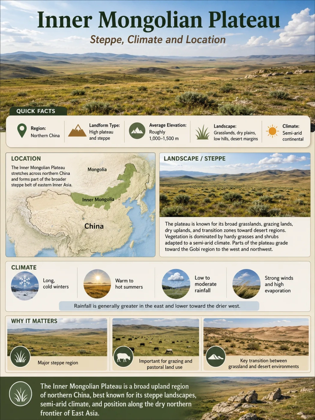
The Inner Mongolian Plateau is a broad upland of northern China, known for open steppe, dry continental climate, rolling grasslands, desert margins and a long transition from the Greater Khingan forests in the east toward drier Gobi landscapes in the west.
The Inner Mongolian Plateau, also called the Inner Mongolia Plateau, is one of the major plateau landscapes of China. It lies mostly within the Inner Mongolia Autonomous Region and forms the southern part of the larger Mongolian Plateau, a high interior tableland that extends across Mongolia and northern China.
This plateau is not a single flat sheet of land. It is a wide upland region made of grassland, sandy land, desert steppe, low hills, dry basins and mountain-fringed margins. Its geography helps explain why Inner Mongolia is often associated with open steppe, strong winds, long winters and large pastoral landscapes.
| Feature | Inner Mongolian Plateau |
|---|---|
| Name | Inner Mongolian Plateau / Inner Mongolia Plateau |
| Location | Northern China, mainly within the Inner Mongolia Autonomous Region |
| Larger Landform | Southern part of the Mongolian Plateau |
| Approximate Elevation | Commonly described around 1,000–2,000 meters above sea level, with many central areas near 1,000–1,200 meters |
| Main Landscape | Steppe, desert steppe, sandy land, dry basins, low hills and mountain margins |
| Climate | Temperate continental; cold dry winters, warm summers, strong seasonal temperature changes and rainfall that generally decreases westward |
| Known For | Grassland, pastoral land use, wide open terrain, dry climate and its position between the Gobi and northern China’s farming regions |
Measurement Note
Area and elevation figures vary because different sources draw the plateau boundary in different ways. Some descriptions focus on the core Inner Mongolian Plateau, while others include wider desert, steppe or transitional belts. For this reason, careful wording such as “about,” “roughly” and “commonly described as” is more accurate than a single fixed number.
Where Is The Inner Mongolian Plateau Located?
The Inner Mongolian Plateau sits across northern China in a long east-west arc. It follows the general shape of Inner Mongolia, which stretches from the forests and river valleys near northeast China toward the drier lands close to the Gobi and northwestern China.
On a broad map, the plateau lies south of Mongolia and north of the North China Plain, the Loess Plateau and several mountain belts. It is not isolated from nearby landforms. Instead, it works like a high transitional belt between Central Asian drylands and the more settled lowlands and basins of northern China.
Map Note
To locate the plateau, look for the long Inner Mongolia Autonomous Region across northern China. The plateau is the high, open upland belt behind that regional name, especially the areas of grassland, desert steppe and sandy land between the Greater Khingan Range in the east and the drier western basins.
Main Regional Connections
East
Greater Khingan Range
The eastern side rises toward forested mountains and river valleys. This area is wetter than the western plateau and forms a clear change from grassland to wooded upland.
Central
Xilin Gol And Open Steppe
Central Inner Mongolia is strongly linked with steppe landscapes, grazing areas and wide rolling terrain. This is one of the clearest plateau-steppe zones.
Southwest
Ordos And Yellow River Bend
The southwest connects with the Ordos region, where the Yellow River makes a broad loop and dry plateau land meets irrigated valleys and desert margins.
West
Gobi And Desert Steppe
Toward the west and northwest, the plateau becomes drier, with more desert steppe, sandy surfaces, stony ground and sparse vegetation.
Elevation And Surface Shape
The Inner Mongolian Plateau is usually described as a high tableland, but its surface is not perfectly level. Much of it stands around 1,000 meters or more above sea level, while some plateau descriptions place the broader elevation range between about 1,000 and 2,000 meters.
The surface often looks open and gently rolling rather than sharply mountainous. Low hills, shallow basins, sand-covered areas and dry valleys break up the plateau. This gives the land a broad, open character without making it a flat plain.
Elevation Note
The plateau is high enough to shape climate and drainage, but it is much lower than the Tibetan Plateau. Its identity comes less from extreme height and more from its wide elevated surface, dry interior position and steppe landscape.
Why It Is A Plateau, Not A Plain
A plain can be low, flat and close to sea level. A plateau is a raised landform with a broad upper surface. The Inner Mongolian Plateau fits the second pattern because it sits as an elevated upland, even where the land looks gently rolling.
The plateau also has clear relationships with surrounding mountains, basins and river systems. These edges and transitions make it different from a simple lowland plain.
Plateau Character
- Raised above nearby lowlands
- Broad upland surface
- Steppe, desert steppe and dry basins
- Climate shaped by elevation and continental location
Plain Character
- Usually lower in elevation
- Often smoother and more continuous
- May be formed by river deposits or coastal processes
- Climate depends more on latitude, oceans and local relief
Steppe Climate And Grassland Landscape
The climate of the Inner Mongolian Plateau is strongly continental. The land is far from the sea, so temperatures can change sharply between seasons. Winters are long, cold and dry. Summers are warmer, with most rain falling in the warmer months.
Rainfall is uneven. The east is generally wetter, especially near the Greater Khingan Range and the Hulunbuir area. The west is much drier and moves toward desert steppe and Gobi-like conditions. This east-to-west rainfall gradient is one of the most important facts for understanding the plateau.
| Zone | Typical Landscape | Climate Pattern | Geographic Meaning |
|---|---|---|---|
| Eastern Plateau | Grassland, forest-steppe edges and mountain valleys | Relatively wetter than the west | Links the plateau with the Greater Khingan Range and northeast China |
| Central Plateau | Open steppe, rolling grassland and grazing areas | Dry continental climate with strong seasonal changes | Represents the classic Inner Mongolian steppe image |
| Western Plateau | Desert steppe, sandy land, dry basins and stony surfaces | More arid, with lower and less reliable rainfall | Forms a transition toward the Gobi and northwestern drylands |
Why Steppe Dominates The Plateau
Steppe forms where rainfall is too low for dense forest but enough, in many places, to support grasses and drought-resistant plants. On the Inner Mongolian Plateau, this balance changes from east to west. The result is not one uniform grassland, but a chain of landscapes from meadow steppe to typical steppe, desert steppe and desert margins.
Wind is also part of the plateau’s climate story. Open terrain, dry surfaces and strong seasonal pressure differences can create windy conditions, especially in exposed western and central areas. This affects soil movement, sand transport and the shape of grassland vegetation.
Field Note
“Steppe” does not mean empty land. It describes a dry grassland system where climate, soil, grazing, wind and seasonal rainfall all work together. The Inner Mongolian Plateau is one of the clearest places to see this relationship on a large map.
How The Inner Mongolian Plateau Formed
The plateau is part of the wider geological framework of northern China and Central Asia. Its present form reflects long-term uplift, old basement rocks, sediment cover, wind action, erosion and the development of dry interior basins.
Unlike a volcanic plateau made mainly from thick lava flows, the Inner Mongolian Plateau is better understood as a broad continental upland shaped by tectonic stability, regional uplift, erosion, wind-blown deposits and dryland surface processes. Sand, loess-like material, gravel plains and basin sediments help give different parts of the plateau their surface texture.
Old Continental Foundation
The plateau rests on old crustal blocks and long-lived inland terrain. This gives the region a broad structural base rather than a narrow mountain-chain shape.
Regional Uplift And Tilting
Slow uplift and regional tilting helped raise parts of the surface above nearby lowlands. The result is a wide tableland rather than a single steep ridge.
Dryland Erosion And Basin Development
Rivers, wind and seasonal runoff shaped shallow basins, dry valleys, sandy land and open steppe surfaces over long periods.
Wind And Sediment Reworking
In drier areas, wind moves sand and fine sediment. This helps create desert steppe, sandy patches and the softer surface forms seen across parts of the plateau.
Is It A Volcanic Plateau?
The Inner Mongolian Plateau should not be treated as a simple volcanic plateau. Some areas of Inner Mongolia and nearby regions contain volcanic landforms, but the plateau as a whole is not defined mainly by lava sheets. Its identity comes from its broad raised surface, dry continental setting, steppe cover and position within the larger Mongolian Plateau.
Landform Note
The plateau is best read as a large inland tableland with dryland and steppe processes. Calling it only “volcanic” or only “flat grassland” misses the mix of uplift, basins, wind-shaped surfaces, mountains and drainage patterns that define it.
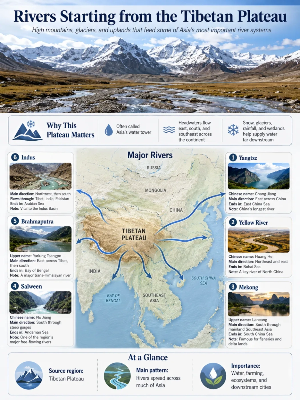
Rivers, Basins And Drainage
Water on the Inner Mongolian Plateau is unevenly distributed. Some areas connect to large river systems, while other areas have short, seasonal or intermittent streams. In the drier interior, water may collect in shallow lakes, salt lakes or closed basins rather than flowing steadily to the sea.
The Yellow River is the most important river associated with the southern and southwestern plateau margins. Its great bend surrounds parts of the Ordos region and provides water for irrigated areas along the river corridor. This creates a strong contrast between dry plateau land and cultivated river valleys.
In the northeast, the Argun or Ergun River system is important near the border zone with Russia and Mongolia. Eastern drainage is more connected to forested uplands and river valleys, while the central and western plateau includes more dry basins and seasonal watercourses.
Major River Link
Yellow River Bend
The Yellow River forms a large loop through south-central Inner Mongolia and shapes the Ordos margin, irrigation zones and nearby dryland geography.
Northeast Drainage
Argun / Ergun System
Near the northeast, river valleys connect the plateau edge with the Amur river system and the Greater Khingan landscape.
Interior Pattern
Seasonal Streams And Basins
Many drier areas do not have large permanent rivers. Water may appear seasonally, collect in shallow basins or end in lakes and salt flats.
Mountains And Edges Around The Plateau
The Inner Mongolian Plateau is easier to understand when its edges are included. Mountains and ridges do not simply surround the plateau; they help define its climate, drainage and map shape.
| Feature | Position | Role In The Plateau Landscape |
|---|---|---|
| Greater Khingan Range | Eastern Inner Mongolia | Marks a wetter, more forested upland edge and separates steppe areas from parts of northeast China |
| Yin Mountains | Southern margin | Help form the divide between the plateau and lower regions to the south |
| Helan Mountains | Southwestern edge | Stand near the transition between Inner Mongolia, Ningxia and dry western landscapes |
| Gobi Margins | West and northwest | Connect the plateau to desert steppe, stony plains and very dry interior basins |
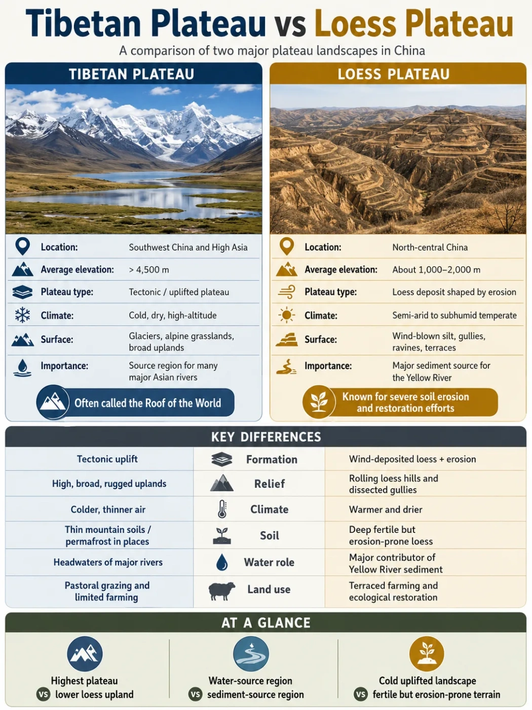
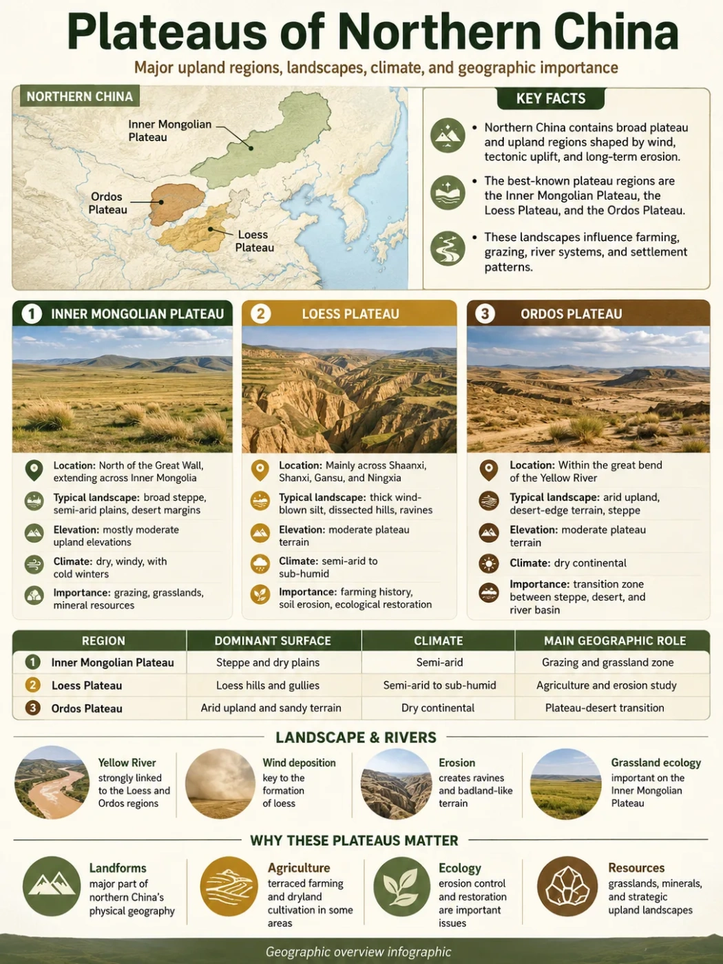
How It Differs From Nearby Plateaus
The Inner Mongolian Plateau is sometimes confused with the Mongolian Plateau, the Ordos Plateau and the Loess Plateau. These names overlap in regional geography, but they do not mean exactly the same thing.
| Landform | Where It Is | Main Identity | How It Differs |
|---|---|---|---|
| Inner Mongolian Plateau | Mainly Inner Mongolia, northern China | Steppe and desert-steppe plateau within China | More specific than the full Mongolian Plateau and strongly tied to Inner Mongolia’s grassland belt |
| Mongolian Plateau | Mongolia and Inner Mongolia | Larger Central Asian tableland including Gobi and steppe regions | Broader regional plateau that crosses the China-Mongolia political divide |
| Ordos Plateau | Inside the Yellow River bend, south-central Inner Mongolia and nearby areas | Dry plateau and desert-margin landscape | More localized; closely tied to the Yellow River loop and Ordos region |
| Loess Plateau | South of Inner Mongolia across parts of north-central China | Thick wind-blown silt, deeply cut gullies and river erosion | More strongly defined by loess deposits and dissected erosion landforms |
Common Mix-Up
The Inner Mongolian Plateau is not the same as the entire Mongolian Plateau. The larger Mongolian Plateau includes Mongolia and Inner Mongolia, while the Inner Mongolian Plateau refers mainly to the plateau region within China’s Inner Mongolia.
Why The Inner Mongolian Plateau Matters In Geography
The plateau matters because it links landform, climate, vegetation and human land use in a clear way. Its open steppe is not random scenery; it reflects elevation, dry continental air, seasonal rainfall, wind and the limits of farming in a semi-arid environment.
The plateau also helps explain several larger geographic patterns in northern China:
- Climate transition: it marks a shift from wetter eastern uplands to drier western basins and desert steppe.
- Land use transition: it sits between pastoral grassland zones and farming regions farther south and east.
- Drainage contrast: it includes both river-linked margins and interior dry basins.
- Map recognition: it forms one of the major plateau belts used to describe China’s physical geography.
- Ecological value: its grasslands support drought-resistant vegetation and pastoral systems adapted to seasonal conditions.
People, Pastoral Life And Land Use
For many readers, the Inner Mongolian Plateau is closely associated with grasslands and livestock grazing. This link has a strong geographic basis. Grassland areas can support grazing where rainfall is too limited for dense forest and where dry farming is more difficult.
Pastoral land use has long been connected to the plateau’s seasonal climate. Cold winters, summer rainfall, open terrain and variable grass growth all affect how people use the land. In river valleys and irrigated areas, farming becomes more possible, especially near the Yellow River corridor.
The plateau should not be simplified into one lifestyle or one landscape. Inner Mongolia includes cities, mining areas, farms, grasslands, deserts, forests and river valleys. The plateau is the physical base behind many of these patterns, but the region itself is varied.
Geography Note
Descriptions of the plateau should avoid treating it as only “grassland.” Grassland is central, but the full plateau also includes sandy land, desert steppe, dry basins, mountain margins, river corridors and settled areas.
Useful Terms For Reading This Plateau
Plateau
A raised landform with a broad upper surface. The Inner Mongolian Plateau is high and wide, even where the surface looks gently rolling.
Steppe
A dry grassland landscape, usually found where rainfall is limited. Steppe is one of the main vegetation types on the plateau.
Desert Steppe
A drier form of steppe with sparse grasses, shrubs and exposed ground. It becomes more common toward the western and northwestern plateau.
Interior Basin
A basin where water may collect inland instead of reaching the sea. Some dry parts of the plateau have seasonal streams, shallow lakes or salt-lake basins.
Escarpment
A steep slope or edge that separates higher land from lower land. Plateau margins and nearby mountain fronts can create escarpment-like boundaries.
Continental Climate
A climate shaped by distance from oceans, often with hot or warm summers, cold winters and large seasonal temperature changes.
FAQ
Where is the Inner Mongolian Plateau?
The Inner Mongolian Plateau is in northern China, mainly within the Inner Mongolia Autonomous Region. It forms the southern part of the larger Mongolian Plateau, which also extends into Mongolia.
Is the Inner Mongolian Plateau the same as the Mongolian Plateau?
No. The Mongolian Plateau is the larger regional plateau across Mongolia and Inner Mongolia. The Inner Mongolian Plateau is the part mainly associated with China’s Inner Mongolia.
What is the Inner Mongolian Plateau known for?
It is known for steppe grasslands, dry continental climate, desert-steppe transitions, pastoral land use and its role as one of China’s major plateau regions.
How high is the Inner Mongolian Plateau?
Many descriptions place much of the plateau around 1,000 meters or more above sea level, with broader plateau ranges often described around 1,000–2,000 meters. Exact figures vary by boundary definition.
What type of climate does the Inner Mongolian Plateau have?
It has a temperate continental climate. Winters are cold and dry, summers are warmer, and rainfall is highly uneven, generally decreasing from the wetter east toward the drier west.
Why is there so much grassland on the plateau?
Grassland forms because rainfall is limited but not absent. The climate is dry enough to restrict dense forest in many areas, yet seasonal moisture can support steppe grasses and drought-resistant plants.
Does the plateau have major rivers?
Some margins connect to major river systems, especially the Yellow River in the southwest and northeast river systems near the Greater Khingan area. Many interior areas have seasonal streams, shallow basins or limited drainage.
Is the Inner Mongolian Plateau flat?
It can look open and broad, but it is not perfectly flat. The plateau includes rolling grassland, low hills, sandy land, dry basins, mountain edges and desert-steppe surfaces.