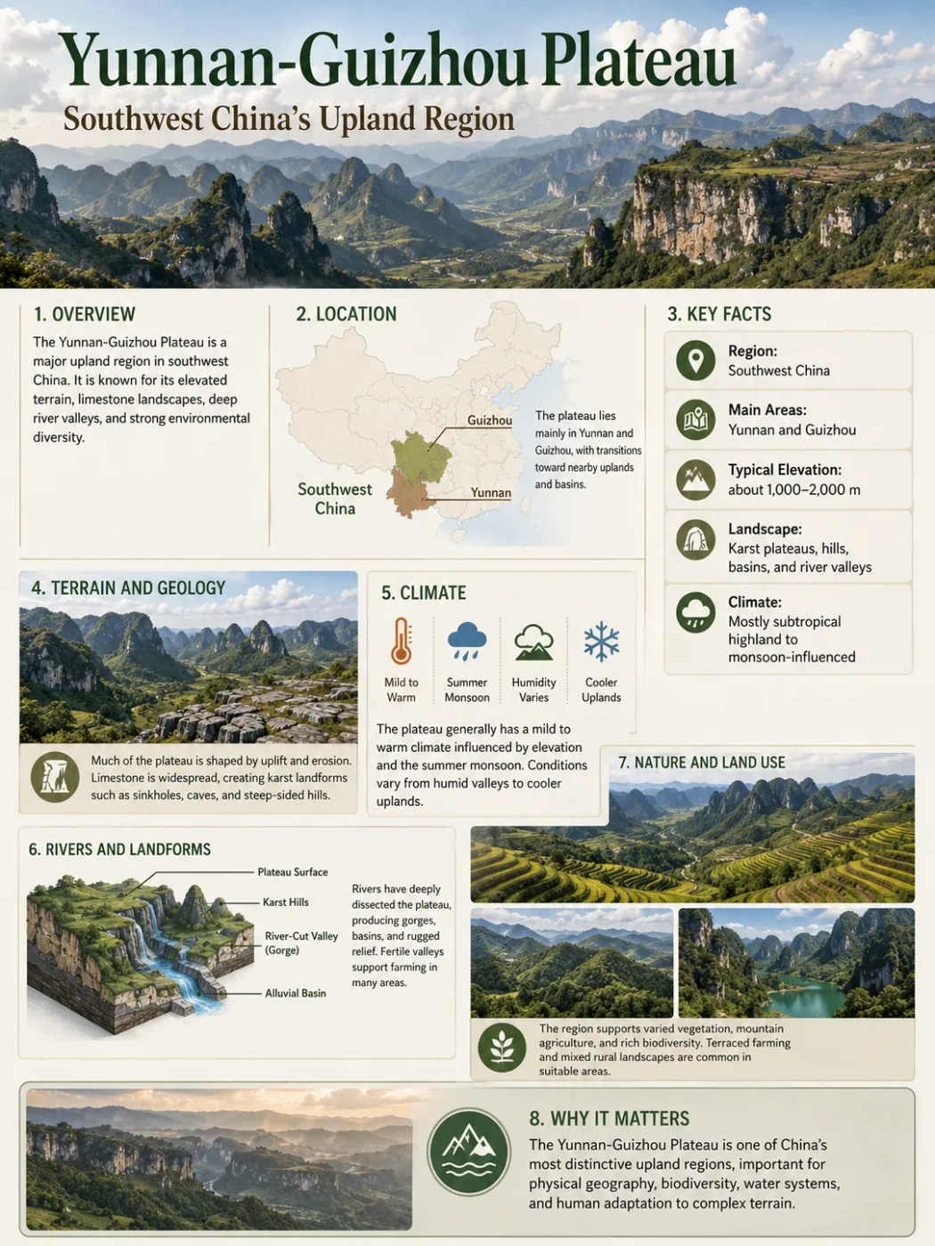
Southwest China Landform Profile
The Yunnan-Guizhou Plateau, also called the Yungui Plateau, is a rugged upland region where limestone hills, folded mountains, lake basins, deep gorges and humid subtropical karst landscapes meet. It is not a flat tableland. It is a broken highland zone that helps shape rivers, climate, farming areas and settlement patterns across southwest China.
The Yunnan-Guizhou Plateau sits in southwest China, between the higher mountain systems of western China and the lower hills and basins of southern and eastern China. Its surface changes quickly: one area may show rolling uplands, another may drop into a limestone gorge, and another may open into a small basin where cities and farms have room to grow.
The plateau is best understood as a transition landform. To the west and northwest, terrain rises toward the Hengduan Mountains and the edge of the Tibetan Plateau. To the east and southeast, the land descends toward Guangxi, Hunan and the broader lowland landscapes of southern China.
| Feature | Yunnan-Guizhou Plateau Profile |
|---|---|
| Name | Yunnan-Guizhou Plateau, Yungui Plateau, Yunnan-Guizhou Highlands |
| Location | Southwest China, mainly across Yunnan and Guizhou provinces |
| Approximate Elevation | Often described around 2,000 m in parts of Yunnan and around 1,200 m in much of Guizhou, with higher mountains and lower basins interrupting the surface |
| Main Landform Type | Dissected plateau with karst hills, folded mountains, gorges, basins and limestone uplands |
| Climate | Mostly subtropical, with local changes caused by elevation, cloud cover, slope direction and valley depth |
| Major Drainage Links | Connected to upper branches and tributaries of major river systems, including the Yangtze and Pearl River basins; western margins connect with deep north-south river valleys |
| Known For | Karst scenery, stone forests, underground streams, sinkholes, natural bridges, terraced farming, mountain basins and deeply cut river valleys |
Map Note
The plateau does not have a sharp border like a political boundary. On maps, it is better read as a broad upland zone: higher and more mountainous toward Yunnan, more karst-dissected across Guizhou, and gradually lower toward Guangxi and nearby lowland regions.
Where the Yunnan-Guizhou Plateau Is Located
The plateau covers a large part of southwest China, especially the upland areas of Yunnan and Guizhou. The Yunnan section is commonly linked with rolling highlands, lake basins and mountain ranges. The Guizhou section is more strongly known for limestone karst, steep slopes and limited flat ground.
Its position matters because it forms a bridge between several larger physical regions:
- To the northwest: the Hengduan Mountains and the high terrain leading toward the Tibetan Plateau.
- To the north: the Sichuan Basin and mountain barriers along the plateau edge.
- To the east: the hills and lower landscapes of Hunan and nearby regions.
- To the south and southeast: Guangxi and the wider South China karst belt.
- To the southwest: river valleys and mountain corridors linked with the Red River and other south-flowing systems.
This setting gives the plateau a broken outline. It is not one simple slab of land. It is a chain of uplands, basins, ridges and karst fields that changes from one province to the next.
Map Position
Southwest China
The plateau sits between high western mountains and lower southern and eastern landscapes.
Province Link
Yunnan and Guizhou
Yunnan gives the plateau broader upland basins and higher mountain influence. Guizhou gives it some of China’s clearest karst relief.
Terrain Style
Broken Highland
The surface includes hills, ridges, sinkholes, gorges, small basins and deeply incised river valleys.
Geographic Role
Drainage Divide
Parts of the plateau influence water flow toward major basins, including the Yangtze and Pearl River systems.
Elevation and Surface Shape
The Yunnan-Guizhou Plateau is often described through two different elevation patterns. The Yunnan side is generally higher, with broad upland areas around roughly 2,000 m in many descriptions and mountain peaks rising higher in the west. The Guizhou side is commonly lower on average, often around 1,200 m, but it is more sharply broken by limestone hills, gorges and karst depressions.
This difference explains why the plateau can feel confusing on a map. A plateau does not need to be perfectly flat. It only needs to be an elevated landform with a relatively broad upland character compared with surrounding lower regions. Here, that upland surface has been cut, folded and dissolved until much of it looks mountainous.
Elevation Note
Elevation figures for this plateau vary because different references draw the plateau boundary differently. A careful description is better than one fixed number: Yunnan is generally higher and more plateau-like, while Guizhou is lower on average but more heavily dissected by karst and river erosion.
How the Plateau Formed
The Yunnan-Guizhou Plateau formed through a mix of tectonic uplift, folding, faulting, erosion and limestone dissolution. Its rocks include large areas of limestone and other sedimentary layers, along with basalt and older structural zones in some areas. Over long periods, uplift raised the land, while rivers and groundwater cut into it.
The result is a plateau that does not look like a clean tabletop. It is a landform shaped by both upward movement and removal of rock.
Uplift Raised the Region
Tectonic movement helped lift the region into an elevated highland between western mountain systems and lower southern China.
Folding and Faulting Broke the Surface
Rock layers were bent, fractured and offset, creating ridges, basins and steep slopes instead of one smooth plateau surface.
Limestone Dissolved into Karst
Rainwater and groundwater dissolved limestone, forming sinkholes, caves, underground streams, natural bridges and stone pinnacles.
Rivers Cut Deep Valleys
Streams and larger rivers carved gorges through the uplifted land, making the plateau more rugged over time.
Karst: The Plateau’s Most Recognizable Landform
The Yunnan-Guizhou Plateau is one of the best-known karst regions in China. Karst forms where soluble rocks, especially limestone, are slowly dissolved by water. This process creates a landscape with caves, enclosed depressions, disappearing streams, sharp hills and underground drainage.
In Yunnan, the Shilin Stone Forest area is a famous example of pinnacle karst. In Guizhou, cone karst, tower karst, gorges and underground streams are especially common. These landforms also connect the plateau with the wider South China karst belt, which extends beyond the plateau toward Guangxi and Chongqing.
| Karst Feature | What It Means | How It Appears on the Plateau |
|---|---|---|
| Sinkhole | A closed depression formed by dissolution or collapse | Common in limestone areas where surface water drains underground |
| Cave | An underground opening enlarged by water moving through rock | Often linked with subterranean streams and steep limestone slopes |
| Natural Bridge | A rock arch left behind after erosion or cave collapse | Found in deeply eroded karst terrain where water cuts through limestone |
| Stone Forest | A field of tall limestone pinnacles | Strongly associated with parts of Yunnan, especially the Shilin area |
| Tower or Cone Karst | Steep isolated hills rising from lower ground | Seen in parts of Guizhou and the wider South China karst region |
Landform Note
Karst terrain can make distance misleading. Two places may look close on a map, but cliffs, enclosed basins, underground drainage and deep valleys can make movement across the plateau difficult.
Yunnan Side and Guizhou Side: Why They Feel Different
The name Yunnan-Guizhou Plateau joins two provinces, but the landform is not the same across both. The Yunnan side is usually more open in some upland basin areas and more strongly connected to western mountain systems. The Guizhou side is more densely carved by limestone karst, folded rock, steep valleys and small patches of level land.
Yunnan Side
- Generally higher in many plateau descriptions.
- Includes rolling uplands, lake basins and mountain-framed valleys.
- Linked with major lakes such as Dianchi and Fuxian Lake.
- Western areas connect toward deeper river valleys and higher mountains.
Guizhou Side
- Often lower on average but more rugged in surface detail.
- Strongly shaped by limestone karst, sinkholes and underground streams.
- Has many steep slopes, gorges and limited broad flat land.
- Important for upper Yangtze and Pearl River drainage links.
Common Mix-Up
The Yunnan-Guizhou Plateau should not be pictured as one flat shelf. It is better read as a highland region where plateau surfaces, mountain ridges, river gorges and karst basins sit close together.
Rivers, Basins and Drainage
Water gives the plateau much of its shape. Rivers cut into uplifted land, while karst groundwater disappears into caves and reappears in springs or valley systems. Surface drainage is uneven because limestone allows water to move underground as well as across the surface.
Across Guizhou, many rivers are linked with the upper parts of larger systems. Northern and eastern drainage connects with the Yangtze River basin, including tributary networks such as the Wu River system. Southern drainage connects toward the Pearl River basin, including headwater areas linked with the Nanpan and Beipan rivers.
In and near Yunnan, the plateau also sits close to major river corridors that flow through deep mountain valleys. These include river systems associated with the upper Yangtze, Mekong and Salween regions to the west and northwest of the broader upland zone.
Yangtze Link
Northern and Eastern Drainage
Parts of the plateau drain toward tributaries of the Yangtze system, especially across Guizhou’s northern and eastern slopes.
Pearl River Link
Southern Drainage
Southern areas connect with headwaters and tributaries of the Pearl River system, including Nanpan and Beipan river areas.
Karst Water
Underground Streams
Limestone terrain allows water to sink below the surface, creating caves, springs and hidden drainage routes.
Lake Basins
Yunnan Upland Lakes
Some Yunnan basins hold lakes and more open farming land, making them easier places for settlement than steep karst slopes.
Climate and Landscape
The plateau has a mostly subtropical highland influence, but climate changes sharply with elevation and slope. Guizhou is known for mild temperatures, cloudiness and frequent rain. Yunnan has strong local contrasts: some upland basins are mild, while deep valleys can be warmer and mountain areas cooler.
Elevation softens summer heat in many places. Cloud cover and moist air also affect temperature and rainfall. This is one reason cities such as Guiyang and Kunming are often described through mild climate rather than extreme heat or cold.
| Climate Factor | Effect on the Plateau |
|---|---|
| Elevation | Moderates temperature and creates cooler conditions than nearby lowlands at similar latitude |
| Karst Relief | Creates local slope, valley and basin differences in soil, water storage and vegetation |
| Cloud Cover | Common in parts of Guizhou, helping reduce strong summer heating |
| Monsoon Influence | Brings seasonal rainfall, especially in warmer months across much of the region |
| Valley Depth | Deep gorges may be warmer or more humid than nearby uplands, depending on exposure and airflow |
Major Cities and Human Use
The plateau’s people, towns and farms are shaped by the shortage of broad flat land. Settlement often gathers in basins, valley floors and gentler uplands. Steep limestone slopes and deeply cut valleys are harder to farm and build across.
Kunming, in Yunnan, sits in an upland basin and is one of the best-known cities associated with the plateau region. Guiyang, in Guizhou, lies within a more rugged karst province where hills, basins and river valleys shape urban growth. Other cities and towns often occupy pockets of flatter land between ridges.
Farming on the plateau depends heavily on local relief. Basin floors and gentler slopes can support crops, while steep limestone terrain may have thin soils and exposed rock. In some areas, terracing helps people use slopes more carefully.
Field Note
Flat land is not evenly distributed across the plateau. A small basin may support dense settlement and farming, while nearby slopes may be rocky, steep and difficult to use. This patchwork pattern is a key part of the plateau’s human geography.
How the Plateau Differs from Nearby Landforms
The Yunnan-Guizhou Plateau is often compared with the Tibetan Plateau, the Sichuan Basin, the Guangxi karst region and the Loess Plateau. These comparisons help explain what makes it distinct.
| Landform | Main Difference from the Yunnan-Guizhou Plateau |
|---|---|
| Tibetan Plateau | Much higher, broader and colder; often called the highest major plateau region on Earth |
| Sichuan Basin | A lower basin north of the plateau, surrounded by higher terrain rather than forming an upland surface itself |
| Guangxi Karst Region | Lower and more basin-like in many areas, with famous tower karst landscapes continuing from the South China karst belt |
| Loess Plateau | Formed and shaped mainly by thick wind-blown loess deposits and water erosion, not by humid subtropical limestone karst |
| Hengduan Mountains | A more strongly mountain-dominated region to the west and northwest, with deep parallel river valleys and higher relief |
Why the Plateau Matters in Geography
The Yunnan-Guizhou Plateau matters because it shows how a plateau can be both elevated and intensely dissected. It also shows how geology, climate and water movement can work together to create a landform that is hard to classify at first glance.
Its importance can be read in several ways:
- Karst reference region: It contains some of China’s clearest limestone karst landscapes, including stone forests, caves and underground streams.
- Drainage control: It helps divide and redirect water toward major river basins.
- Climate modifier: Elevation and cloud cover create milder conditions than many nearby lowland areas.
- Settlement pattern: People often concentrate in basins and valleys because broad flat land is limited.
- Map-reading lesson: It proves that a plateau can include mountains, gorges and uneven terrain.
Measurement Note
Plateau area, average elevation and exact boundaries are not always reported in the same way. Some descriptions focus on the Yunnan and Guizhou provincial uplands, while others connect the plateau to the wider South China karst belt. For that reason, this profile uses careful ranges and regional descriptions rather than one fixed border line.
Simple Map-Reading Rules
On a physical map, the Yunnan-Guizhou Plateau can be recognized by looking for three patterns at the same time: elevation, roughness and drainage.
Rule 1
Look for Elevated Terrain
The plateau sits above nearby lowlands, but it is not as high or broad as the Tibetan Plateau.
Rule 2
Notice Broken Relief
Karst hills, gorges and folded ridges make the surface rough rather than flat.
Rule 3
Follow River Direction
Rivers and tributaries move away from upland divides toward larger basins such as the Yangtze and Pearl systems.
Useful Terms for Understanding This Plateau
Plateau
An elevated landform with a broad upland character. A plateau can be deeply cut by rivers and still remain a plateau.
Karst
A landscape formed by the dissolution of soluble rock, especially limestone. It often includes caves, sinkholes, underground streams and steep hills.
Dissected Plateau
A plateau that has been cut into by rivers and erosion, leaving ridges, valleys and irregular upland surfaces.
Basin
A lower area surrounded by higher ground. On this plateau, basins often support cities, lakes and farming.
Escarpment
A steep slope or edge that marks a change in elevation. Plateau margins and faulted terrain may form escarpment-like edges.
River Incision
The process of rivers cutting downward into rock, creating deep valleys and gorges through uplifted land.
FAQ
Where is the Yunnan-Guizhou Plateau?
The Yunnan-Guizhou Plateau is in southwest China, mainly across Yunnan and Guizhou provinces. It lies between higher western mountain regions and lower southern and eastern landscapes.
Is the Yunnan-Guizhou Plateau flat?
No. It is an elevated upland region, but much of its surface is rugged. Karst hills, folded mountains, gorges, basins and river valleys break the plateau into uneven terrain.
What is the Yunnan-Guizhou Plateau known for?
It is known for limestone karst landscapes, stone forests, caves, sinkholes, natural bridges, underground streams, deep gorges and upland basins. It is also important for river drainage and settlement patterns in southwest China.
How high is the Yunnan-Guizhou Plateau?
Elevation varies by area. Parts of Yunnan are often described around roughly 2,000 m, while much of Guizhou is often described around roughly 1,200 m on average. Local mountains, valleys and basins create large differences.
Why does the plateau have so much karst?
Large areas contain limestone. Over long periods, rainwater and groundwater dissolved the rock, forming caves, sinkholes, underground streams, stone pinnacles and steep karst hills.
Which rivers are connected to the plateau?
Parts of the plateau are linked with tributaries and headwaters of major systems, especially the Yangtze and Pearl River basins. Western margins also sit near deep river corridors associated with southwest China’s larger mountain-and-valley region.
How is it different from the Tibetan Plateau?
The Tibetan Plateau is much higher, broader and colder. The Yunnan-Guizhou Plateau is lower, more humid, more karst-dominated and more broken by basins, limestone hills and river gorges.
Why are basins important on the Yunnan-Guizhou Plateau?
Basins provide some of the more usable land in a rugged region. They often support farming, lakes, towns and transport routes, while nearby slopes may be steep, rocky or difficult to cross.