Plateau Soils and Land Use
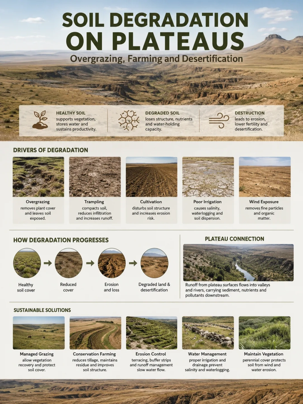
Soil degradation on plateaus begins when vegetation, soil structure and water movement stop supporting one another. Overgrazing and poorly matched farming can turn scattered disturbance into connected erosion, lower fertility and, in dryland plateaus, desertification.
Plateaus are often pictured as broad, level uplands, yet their soils operate across a much more varied surface. A plateau may include rolling grassland, shallow basins, cultivated benches, steep valley heads, gullies and an outer escarpment. Land use on the upper surface can therefore affect slopes, headwaters and river channels far beyond the field or pasture where the disturbance began.
Soil degradation is the lasting decline of soil functions such as plant growth, water storage, nutrient cycling and resistance to erosion. Erosion is one part of that decline, not a synonym for the whole process. A soil can lose structure, organic matter and infiltration capacity before large amounts of sediment are visibly removed.
Landform Note
A relatively flat plateau surface can still produce severe erosion. Runoff may travel across compacted ground, enter livestock tracks or tractor lines, and then accelerate where the plateau is cut by valleys or ends at a steep margin.
| Land-Use Pressure | First Soil Response | Plateau-Scale Expression | Possible Long-Term Outcome |
|---|---|---|---|
| Repeated grazing without recovery | Shorter vegetation, selective plant loss and reduced litter | Bare patches around water points, routes and exposed ridges | Lower forage production, runoff and wind erosion |
| Heavy trampling on wet or fine-textured soil | Compaction, lower pore space and surface sealing | Water ponds or flows across ground that once absorbed rainfall | Rills, root stress and persistent low infiltration |
| Conversion of grassland to cropland | Loss of perennial roots and seasonal soil cover | Large connected areas exposed between planting and harvest | Topsoil loss, nutrient decline and gully growth |
| Repeated tillage and residue removal | Aggregate breakdown and lower organic inputs | Crusting, blowing soil and runoff along rows or wheel tracks | Falling water-holding capacity and unstable yields |
| Poorly managed irrigation in a dry plateau basin | Salt accumulation, waterlogging or soil dispersion | Patchy crop failure and hard or powdery surface conditions | Salinization, sodicity and land abandonment |
Why Plateau Soils Can Be Slow to Form and Fast to Lose
No single soil type defines a plateau. Some plateaus carry deep wind-blown sediment, some have fertile volcanic soils, and others have only a thin layer over sandstone, limestone or crystalline rock. Their resistance to land use depends on soil depth, texture, parent material, climate, vegetation and slope position.
High Elevation Can Shorten the Repair Season
On alpine and cold plateaus, low temperatures and a short growing season limit the time available for plants to replace grazed leaves and rebuild roots. Freeze–thaw cycles loosen some surfaces while compacted or waterlogged layers may remain resistant below. Once vegetation breaks into isolated patches, natural recovery may take many growing seasons.
Cold conditions do not automatically protect soil. A dense alpine turf can hold soil well, but repeated hoof pressure may cut through that turf and expose fine material beneath it. The damage is often concentrated along paths, near camps and around water.
Open Uplands Expose Soil to Wind
Many plateaus have wide, treeless or sparsely wooded surfaces. When grazing or cultivation reduces ground cover, wind can remove silt, clay, organic particles and seed. Water erosion may first detach the material; wind then carries the dried sediment away. This water–wind connection is common in dry and seasonally dry uplands.
Plateau Edges Connect Fields to River Basins
A field near the center of a plateau may seem far from a river, but shallow swales can feed tributary valleys. Sediment moves from sheetwash to small rills, from rills to gullies, and from gullies into a river basin. Where an escarpment or deeply cut valley increases slope, runoff gains enough energy to move coarser material.
This source-to-channel link explains why plateau degradation can affect downstream reservoirs, irrigation works and river water even when the first damage appears as a local pasture problem.
Overgrazing Is a Pattern of Use, Not Just an Animal Count
The number of animals matters, but it does not describe the full grazing pressure. The same herd can have very different effects depending on season, duration, soil moisture, forage condition and movement across the landscape.
Stocking Rate and Grazing Concentration Are Different
A moderate herd spread across a large pasture may leave enough leaf area for regrowth. The same animals gathered around one spring, salt point or narrow passage can remove cover and compact soil within a small zone. Local degradation can therefore be severe even when an average stocking figure looks acceptable.
Plateau topography often strengthens this concentration. Water is not evenly distributed across high surfaces, winter shelter may be limited, and routes through cliffs or dissected terrain can funnel animals through the same ground.
Selective Feeding Changes the Plant Community
Livestock do not remove every species at the same rate. Repeated use often reduces palatable perennial grasses first. Less palatable grasses, low-growing plants, thorny shrubs or short-lived species may expand into the opened space.
The shift matters below ground as well as above it. Deep, dense root systems hold aggregates, create pores and supply organic matter. A pasture can remain green while losing the plants that once gave the soil its strongest protection.
Trampling Alters the Soil–Water Relationship
Hooves press particles together, break surface crusts and disturb root crowns. The effect depends on animal size, hoof form, soil texture and moisture. Wet fine-textured soil is especially prone to compaction, while very dry soil may be pulverized into loose material that is easily blown or washed away.
Compaction reduces large pores. Rainfall then enters more slowly, so more water remains on the surface. What looks like a water shortage may partly be an infiltration problem: rain falls, but the soil cannot store enough of it for later plant use.
Grazing Can Also Be Compatible With Soil Health
Grazing is not automatically degradation. Many plateau grasslands developed with large herbivores and continue to support livestock. Well-timed use can recycle nutrients, prevent excessive dead material from accumulating and maintain open grassland structure.
The dividing line is whether plants and soil receive enough recovery time. Flexible movement, rest periods and drought-year adjustments are usually more informative than a fixed claim that grazing is either always harmful or always restorative.
How Farming Opens New Erosion Pathways
Plateau agriculture often occupies broad upland surfaces, rolling margins or valley-side benches. Some of these soils can be highly productive. The risk rises when cultivation removes perennial cover, leaves long slopes exposed or treats different soil depths as though they have the same capacity.
Grassland Conversion Removes a Continuous Root Network
Natural grassland protects soil through living cover, standing stems, litter and roots. Ploughing replaces that year-round network with a crop that may cover the land for only part of the year. Before germination and after harvest, a large area can remain open to rain splash and wind.
The first seasons may still produce good yields because the newly cultivated topsoil contains stored nutrients and organic matter. Decline becomes clearer later, after erosion, residue removal and repeated disturbance reduce those reserves.
Rows, Wheel Tracks and Field Boundaries Redirect Water
Water follows small differences in height. Furrows running downslope can act as channels, while tractor tracks may collect runoff from a much wider area. A poorly placed field drain can discharge directly onto a fragile slope or gully head.
Contour-aligned cultivation can slow flow on suitable slopes, but it is not a stand-alone cure. Soil cover, field length, rainfall intensity and safe outlets for excess water still determine whether runoff remains controlled.
Repeated Tillage Weakens Aggregates
Tillage can create a loose seedbed, yet repeated disturbance breaks stable aggregates and speeds the loss of organic matter. Fine particles may seal the surface after rain. Beneath the tilled layer, a denser zone can restrict roots and downward water movement.
Residue removal adds another pressure. On mixed crop–livestock plateaus, straw and stubble may be needed as feed. Removing nearly all of it leaves little material to soften raindrop impact, reduce evaporation or feed soil organisms.
Irrigation Can Degrade Closed Plateau Basins
Some plateaus contain interior basins with weak drainage. Irrigation water brings dissolved salts, and evaporation leaves part of that salt behind. Without enough drainage, the water table may rise and salts can collect near the root zone. Sodium-rich water can also disperse clay, leaving soil dense when wet and hard when dry.
This pathway differs from wind or water erosion, but the result is similar: lower infiltration, poorer plant growth and a shrinking area of dependable farmland.
How Separate Pressures Become a Degradation Chain
Overgrazing, farming and drought rarely act in isolation. Their effects become more damaging when one process prepares the ground for the next.
Protective Cover Thins
Selective grazing, ploughing or residue removal reduces leaves, litter and perennial roots.
Soil Structure Weakens
Compaction, aggregate breakdown and lower organic inputs reduce pore space and surface stability.
Runoff Becomes Connected
Small bare patches join, and water follows tracks, furrows, roads and natural hollows.
Topsoil and Seed Are Removed
Sheetwash, rills, gullies and wind carry away fine soil, nutrients, organic matter and seed.
Recovery Becomes Harder
Less water enters the soil, plants regrow slowly, yields fall and pressure shifts onto new land.
The connectedness of bare ground is often more revealing than the total bare percentage. Ten small openings separated by rooted plants may lose less soil than one continuous strip that runs downslope into a channel.
When Soil Degradation Becomes Desertification
Desertification is land degradation in arid, semi-arid and dry sub-humid areas. The term describes a geographic setting as well as a process. The same erosion mechanism may be called land degradation on a humid plateau and desertification on a dry plateau.
Common Mix-Up
Desertification does not require an existing desert to advance across the plateau. A dry grassland, shrubland or cultivated upland can become desertified through persistent loss of productivity, vegetation and soil function without turning into a field of sand.
The Shift From Patchy Damage to a Dryland Threshold
Early degradation may remain reversible. Roots survive, nearby plants supply seed, and rainfall still enters enough of the soil to support regrowth. Risk rises when bare areas connect, stable topsoil is lost and repeated drought prevents vegetation from closing the gaps.
A dryland plateau may then enter a self-reinforcing state:
- Less cover exposes soil to heat, rain splash and wind.
- Less infiltration leaves plants with less stored water between storms.
- Less root growth weakens aggregation and reduces organic inputs.
- More runoff carries seed and fine soil into channels.
- Lower production can lead to heavier use of the remaining productive patches.
Climate Pressure Does Not Replace the Land-Use Explanation
Drought can reduce plant cover even on well-managed land. Warmer conditions can raise evaporative demand, change snowmelt timing and alter the length of the growing season. Short, intense storms may produce more runoff than steady rainfall of the same total amount.
Management still shapes the outcome. Two nearby plateau pastures can experience the same drought but respond differently because one retains litter, root cover and infiltration while the other has compacted soil and connected bare ground. Climate acts as an amplifier when land condition is already weak.
Different Plateau Settings Produce Different Failure Paths
The word plateau describes an elevated landform, not one soil or climate. The dominant degradation process changes with sediment, rock, elevation, rainfall and land use.
| Plateau Setting | Typical Sensitivity | Common Degradation Path | Geographic Lesson |
|---|---|---|---|
| Alpine grassland on the Tibetan Plateau | Short growing season, cold soils and freeze–thaw activity | Selective grazing, turf breakage, compaction and expanding bare “black-soil” patches | Recovery can remain slow even after pressure is reduced; grazing, climate and burrowing animals may interact |
| Loess Plateau of China | Deep, fine wind-blown sediment that is easy to detach | Cultivation and cover loss followed by sheet, rill and gully erosion | Upland soil loss becomes sediment in the Yellow River system; revegetation must also fit the regional water balance |
| Ethiopian highland plateaus | Steep cultivated slopes, intense seasonal rain and dense land use | Topsoil removal, nutrient depletion, rills and deep gullies | Field treatment and watershed drainage have to work together |
| Colorado Plateau drylands | Low rainfall, sparse cover and slow-growing biological soil crusts | Trampling damage, compaction, dust production and long-lived changes in soil stability | Vegetation cover alone may hide damage to biocrust, infiltration and soil chemistry |
| Central Asian and Mongolian upland rangelands | High rainfall variability and dependence on seasonal pasture movement | Concentrated grazing near settlements and water, vegetation thinning and wind erosion | Where herds can move may matter as much as the annual number of animals |
| Volcanic plateaus used for intensive farming | Productive but sometimes erosion-prone soils on rolling or dissected terrain | Aggregate loss, surface sealing, runoff and nutrient export | Natural fertility can delay visible yield decline without preventing structural damage |
From Plateau Surface to Escarpment and River Channel
Soil loss is often measured at a plot or field, but plateau geography works at a wider scale. The position of a damaged area within the drainage network controls where its water and sediment go.
Sheetwash Starts the Transfer
Thin, unchannelled flow removes fine particles from bare interspaces. It may leave behind gravel, stones or a sealed surface. Because sheetwash is shallow, it can continue for years without attracting the attention given to a large gully.
Rills Connect the Surface
Once flow follows the same route, small channels form. Livestock paths, field rows and road edges often become preferred lines. Rills collect runoff from a broader area and deliver it to slope breaks.
Gullies Cut Into Stored Soil
Gully heads may retreat upslope after each strong storm. The gully can lower nearby water storage, split fields, block access and expose deeper layers that are less fertile than the original topsoil. Treating the gully floor alone will fail if concentrated runoff continues to arrive from the plateau above.
Escarpments and Valleys Increase Sediment Delivery
Where the plateau edge is steep or deeply dissected, sediment has a short path to a stream. In gentler interior basins, part of the soil may be redeposited downslope rather than leaving the plateau. That deposited layer can bury vegetation or create a false impression that no net loss occurred.
How to Read a Failing Plateau Surface
Field diagnosis should compare a site with the condition expected for its soil, climate and ecological setting. Bare ground is natural in some rocky or arid plateaus, while a similar amount would show severe decline in a humid grassland.
| Visible or Measurable Indicator | What It May Show | Why Context Is Needed |
|---|---|---|
| Widening bare spaces between plants | Loss of protective cover and greater runoff connectivity | Some plateaus naturally contain rock pavement or sparse vegetation |
| Pedestalled plants or exposed roots | Soil has been removed from around rooted vegetation | Wind and water can create similar forms |
| Soil deposited behind plants, fences or stones | Movement of sediment from an upslope source | Deposition does not identify how much soil left the source area |
| Surface crusting or sealing | Aggregate breakdown, low infiltration or raindrop impact | Biological soil crusts may protect dryland soil and should not be confused with physical sealing |
| Deep hoof prints and hard subsurface layers | Trampling and compaction, often under moist conditions | Clay-rich soils can also be naturally dense |
| Change from perennial bunchgrasses to short-lived plants | Selective grazing, drought stress or repeated disturbance | Species composition must be compared with the expected local community |
| Litter moving downslope after storms | Runoff is strong enough to transport surface material | One storm may not represent the longer pattern |
| Lower infiltration and higher bulk density | Reduced pore space and harder root penetration | Measurements vary with texture, moisture and sampling depth |
| Declining aggregate stability | Greater sensitivity to raindrop impact and erosion | Laboratory and field methods can produce different values |
| Rill or gully expansion | Runoff has become concentrated and connected | The water source may lie far upslope or along a road |
Why a Greener Plateau May Still Have Degraded Soil
Satellite images are useful for mapping vegetation change across large plateaus, but greenness is not the same as soil recovery. A site can show more plant biomass while retaining compacted layers, low aggregate stability or a simplified plant community.
Field Note
Recovery should not be judged from vegetation cover alone. Species composition, root structure, litter, infiltration, soil stability and the pattern of bare ground can tell a different story from a seasonal greenness index.
A single low-value or invasive species may spread quickly and create a green signal. Shallow-rooted plants may cover the surface during a wet year but fail during the next drought. Tree planting can also raise vegetation cover while using more soil water than the former grassland.
Remote sensing works best when paired with repeated field measurements. Satellite data can show where change is occurring; field data helps explain what kind of change it is.
Restoration Has to Match the Damage
No single treatment fits every plateau. The first task is to identify whether the main limit is grazing concentration, compaction, loss of soil cover, gully flow, low seed supply, salinity or a combination of these.
Where Grazing Concentration Is the Main Pressure
- Change the timing and length of grazing periods rather than relying only on annual animal totals.
- Protect wet soils and slow-growing alpine vegetation during their most sensitive periods.
- Distribute water and mineral points where doing so will not transfer damage to another fragile site.
- Keep drought plans flexible so herd pressure falls when forage production falls.
- Maintain movement between seasonal pastures where the landscape and land rights allow it.
Where Compaction Limits Infiltration
Rest from trampling may allow roots, soil organisms and wetting–drying cycles to reopen pores. Mechanical loosening can help some cultivated soils, but it may also disturb dryland crusts or create short-lived improvement if the same pressure returns.
The treatment has to reach the compacted depth without exposing more soil to erosion. Removing the cause is usually more durable than repeatedly breaking the symptom.
Where Cropland Is Losing Topsoil
- Keep crop residue or another protective cover on the surface.
- Reduce the frequency and intensity of tillage where soil and crop systems permit.
- Shorten long runoff paths with contour strips, grassed bands or terraces suited to the slope.
- Use stable outlets so diverted water does not start a new gully.
- Match crops and machinery to soil depth, slope and seasonal moisture.
Where Gullies Have Already Formed
Gully repair starts upslope. Runoff volume and speed must be reduced before check structures, reshaping or revegetation can hold. Road drains, field outlets and livestock trails should be included in the same drainage assessment.
Small permeable barriers can slow water and trap sediment in suitable channels. They are not substitutes for treating the source area, and poorly placed barriers can redirect flow into an unprotected bank.
Where Plants Cannot Return on Their Own
Natural recovery depends on living roots, seed, soil moisture and a surface stable enough for seedlings. Severely eroded sites may need locally adapted seed, temporary protection and small surface features that trap water and seed.
Restoration species should fit the plateau’s original ecosystem. A native grassland does not become healthier simply because it gains dense tree cover.
When Livestock Exclusion Helps—and When It Does Not
Temporary exclusion can work where perennial roots remain alive, seed sources are nearby and the soil has not crossed a hard recovery threshold. It gives plants time to rebuild leaf area, litter and roots.
Permanent fencing is less reliable when it moves all animals onto a smaller neighboring pasture, blocks seasonal movement or ignores the need for managed disturbance in an open grassland. Long exclusion may also allow unpalatable plants or dense dry material to accumulate.
The best measure is not whether animals are present. It is whether the site retains soil stability, hydrologic function and a plant community suited to that plateau setting.
Why Tree Planting Is Not a Universal Repair
Some degraded plateaus were once wooded and may benefit from carefully planned woodland recovery. Others are naturally grassland, steppe, shrubland or alpine meadow. Planting trees across all of them can replace one land-use mismatch with another.
Tree roots may stabilize selected slopes, yet dense planting can draw heavily on soil water in dry climates. Fast-growing non-local species may suppress native grasses or fail during drought. On the Loess Plateau, vegetation restoration has reduced erosion across large areas, while research also shows that planting density and species choice have to remain within the available water supply.
The suitable target is the natural and usable vegetation structure of the site, not the highest possible amount of woody cover.
The Human Geography Behind Soil Loss
Plateau degradation is often described as a direct result of farmers or herders using too much land. That description misses the conditions that shape their choices.
Mobility Can Protect Variable Rangelands
Rain and forage may shift across a plateau from year to year. Seasonal movement allows livestock to follow usable pasture while rested areas recover. Roads, fences, settlement growth and uncertain access can narrow that movement and concentrate animals around fewer dependable locations.
Crop Residue Has Competing Uses
Leaving straw on a field protects soil, but households may also need it for feed, bedding or fuel. A conservation plan that treats residue as unused waste may fail because it overlooks those competing needs.
Short-Term Yield Can Hide Long-Term Cost
New cultivation may raise food production for several seasons. The cost appears later through thinner topsoil, higher fertilizer demand, lower drought tolerance and loss of land to gullies. By then, users may have little spare land or income available for recovery work.
The United Nations designated 2026 as the International Year of Rangelands and Pastoralists. The attention is relevant to plateaus because many high, dry and seasonally variable uplands depend on grazing systems in which movement, local knowledge and access to dispersed water and forage shape land condition.
Measuring Whether a Plateau Is Recovering
Recovery takes place at different speeds. Plant cover may respond within a season, while topsoil depth, carbon storage and biological soil crusts may take much longer. Monitoring should therefore combine early, medium-term and slow indicators.
| Monitoring Stage | Useful Indicators | What Improvement Would Look Like | Common False Signal |
|---|---|---|---|
| Early response | Bare-ground pattern, litter movement, new rills, plant survival | Smaller connected gaps, less transported litter and stable seedlings | A wet season produces temporary green cover |
| Soil-water response | Infiltration, runoff, surface sealing and bulk density | Rain enters faster, ponding falls and compacted layers weaken | Surface loosening improves appearance but not the lower soil layer |
| Vegetation recovery | Perennial species, root depth, ground cover and forage stability | Locally expected plants return and persist through dry periods | One fast-spreading species supplies most of the cover |
| Erosion response | Rill density, gully-head movement, sediment traps and channel condition | Channels stop expanding and sediment delivery declines | Sediment is trapped downstream while the source keeps eroding |
| Longer soil recovery | Aggregate stability, organic carbon, nutrient cycling and biocrust condition | Soil holds together, stores more water and supports dependable growth | Vegetation cover rises without recovery of soil structure |