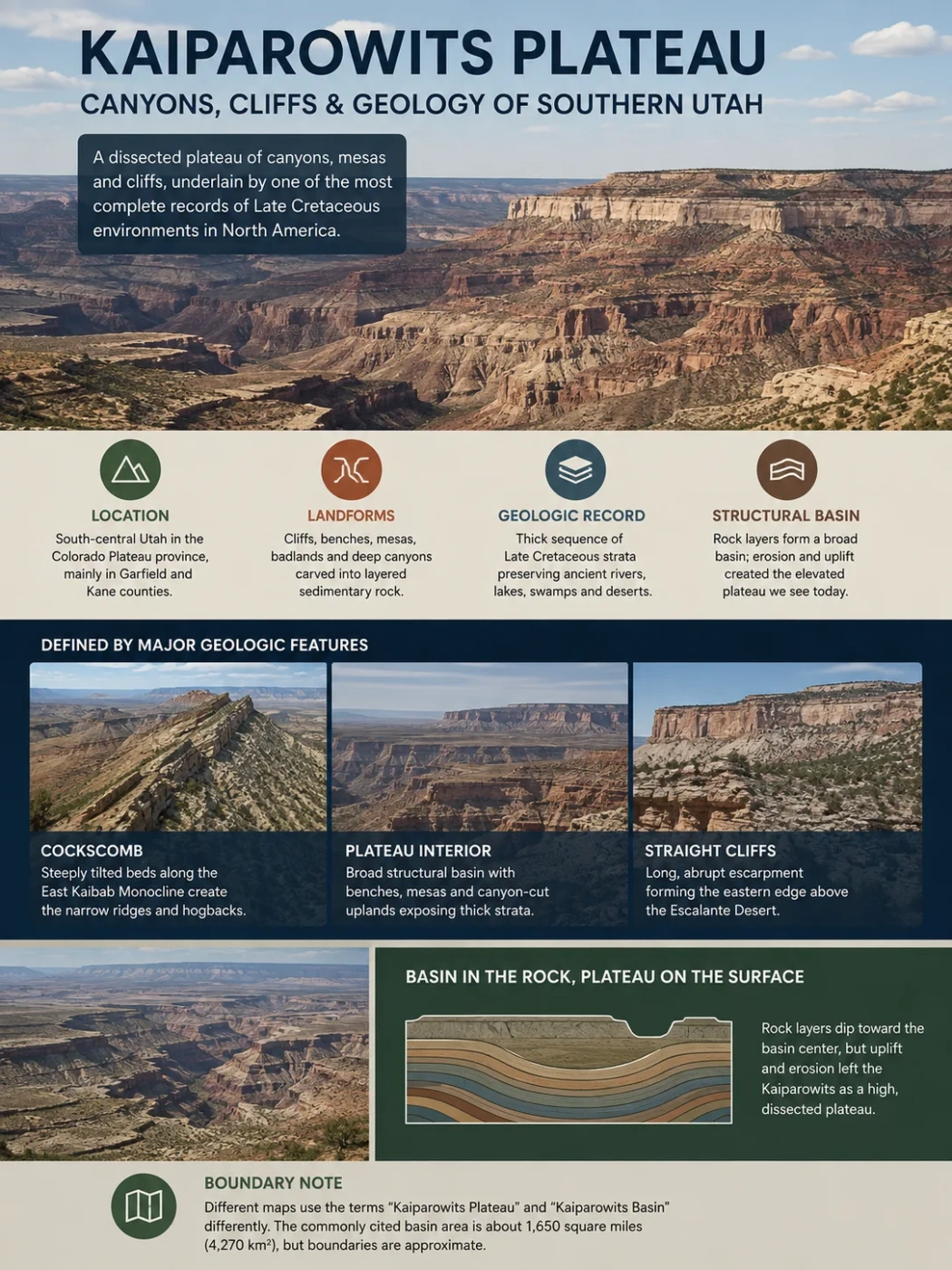
Southern Utah · Colorado Plateau
The Kaiparowits Plateau is not a simple flat-topped upland. Its surface is broken into cliffs, benches, mesas, badlands and deep canyons, while the rock beneath forms a broad structural basin that preserves an unusually thick record of Late Cretaceous environments. The Straight Cliffs define much of its eastern edge, the Cockscomb marks a strongly folded western margin, and erosion has cut the interior into a stepped landscape that exposes coal beds, ancient river deposits and fossil-rich strata.
Dissected Sedimentary Plateau
Late Cretaceous Rock Record
Structural Basin
Where the Kaiparowits Plateau Fits in Southern Utah
The Kaiparowits Plateau occupies a large part of south-central Utah within the Colorado Plateau province, mainly in Garfield and Kane counties. Much of the land lies within Grand Staircase–Escalante National Monument. It stands between the lower country around Lake Powell to the south, the Escalante Desert to the east and higher plateau country toward the north.
Its outline is easier to understand from its landforms than from a single boundary line. The Straight Cliffs form a long, abrupt escarpment along much of the eastern side. To the west, tilted strata along the East Kaibab Monocline create the narrow ridges and hogbacks known as the Cockscomb. The plateau descends southward toward Glen Canyon and the Colorado River system, while its northern terrain rises toward Fiftymile Mountain and the high ground around Canaan Peak.
Boundary Note
Published maps do not always use “Kaiparowits Plateau,” “Kaiparowits Basin” and administrative Kaiparowits units for exactly the same area. A commonly used geologic description gives the Kaiparowits Basin an area of about 1,650 square miles (4,270 km²), but that figure should not be treated as a universally fixed plateau boundary.
East Kaibab Monocline and the Cockscomb
Kaiparowits structural basin, benches, mesas and canyon-cut uplands
Straight Cliffs above the Escalante Desert
A Plateau on the Surface, a Basin in the Rock Structure
One of the most useful facts for understanding Kaiparowits is that topography and geologic structure describe different things. Topographically, the region is a raised, strongly dissected plateau. Structurally, many of its rock layers occupy a broad basin.
A structural basin forms where strata are warped so that they generally dip toward an interior area. That does not require the modern ground surface to be low. Later uplift and erosion can leave the same rocks standing thousands of feet above neighboring terrain.
In the Kaiparowits region, Cretaceous strata were preserved within this structural setting while deformation folded and tilted the surrounding rocks. The East Kaibab Monocline is especially visible on the western side, where erosion through steeply inclined layers produces the Cockscomb. Smaller anticlines and synclines also warp the plateau interior.
Common Mix-Up
“Basin” does not mean that Kaiparowits is a low flat depression today. Structural basin refers to the geometry of the rock layers. Plateau refers to the elevated modern land surface. The same region can therefore be both.
Erosion exposes steeply tilted beds along the East Kaibab Monocline.
A broad structural basin preserves thick Cretaceous sedimentary strata.
Resistant sandstone forms the dominant eastern escarpment.
The diagram shows the relationship schematically and is not a scale geologic cross-section.
Straight Cliffs Form the Plateau’s Sharpest Eastern Edge
The eastern side of the Kaiparowits Plateau changes abruptly rather than fading gradually into the neighboring desert. The Straight Cliffs rise roughly 1,100 feet (335 m) or more above adjacent terrain in places and extend for more than 50 miles along the plateau margin.
Their persistence comes from resistant sandstone beds within the Straight Cliffs Formation. Hard sandstone withstands erosion better than neighboring mudstone and shale, so it remains as steep walls while weaker layers retreat into slopes. Repetition of this contrast is one reason Kaiparowits contains so many escarpments, ledges and benches.
Collet Canyon provides an important break through the eastern cliff line. Unlike most of the plateau’s major drainages, which trend toward the Colorado River system to the south and southeast, Collet Canyon drains eastward toward the Escalante River.
Straight Cliffs and Straight Cliffs Formation Are Not Identical Terms
Straight Cliffs refers to the visible escarpment. Straight Cliffs Formation is a named body of Late Cretaceous sedimentary rock. The formation helps create the cliffs, but it extends beyond a single cliff face and records several different depositional environments.
Four Members Record Changing Environments
The Straight Cliffs Formation is commonly divided, from oldest to youngest, into the Tibbet Canyon, Smoky Hollow, John Henry and Drip Tank members. Their sandstone, mudstone, carbonaceous beds and coal record repeated shifts among shoreline, coastal-plain, wetland and river environments as the Western Interior Seaway advanced and retreated across the region.
| Member | Main Depositional Signal | Landscape or Geologic Expression |
|---|---|---|
| Tibbet Canyon | Marine and shoreface sedimentation | Resistant sandstone associated with prominent cliff-forming intervals |
| Smoky Hollow | Coastal-plain to nonmarine conditions | Sandstone, carbonaceous beds and locally coal-bearing strata |
| John Henry | Shifting coastal, marine and nonmarine environments | Thick sandstone-mudstone succession containing important coal intervals |
| Drip Tank | Predominantly fluvial deposition | Widespread resistant sandstone near the top of the formation |
Why Kaiparowits Rises in a Series of Benches and Cliffs
The plateau does not rise as one continuous block. Its interior contains a sequence of tablelands, benches and escarpments that generally step upward from the Lake Powell side toward the north. Named surfaces include East Clark Bench, Nipple Bench, Brigham Plains, Smoky Mountain, Horse Flat, Long Flat, Fourmile Bench and Collet Top.
This stair-step form reflects differential erosion. Thick, well-cemented sandstone can protect a bench or form a cliff. Softer mudstone and shale weather more rapidly, producing slopes and badlands below it. When several resistant and weak units alternate vertically, erosion turns the rock sequence into a series of topographic steps.
Sandstone, mudstone, shale and coal-bearing intervals accumulate in different environments.
Harder sandstone erodes more slowly than softer mudstone and shale.
Resistant beds stand as ledges or escarpments while weaker strata retreat.
Erosion leaves broad stepped surfaces between canyon systems.
The elevation pattern follows the same broad south-to-north rise. Some low southern benches lie near 4,000–5,000 feet, intermediate surfaces commonly reach roughly 5,600–6,200 feet, and higher northern terrain reaches about 7,000–8,000 feet. Ridges near Canaan Peak rise higher still. These numbers describe different parts of a deeply dissected landscape rather than one representative plateau elevation.
The Rock Sequence Records a Changing Cretaceous Landscape
Kaiparowits preserves far more than one formation. Its exposed Cretaceous succession contains sandstone, mudstone, shale and coal deposited as the western margin of the Western Interior Seaway shifted across southern Utah and was eventually replaced by fully terrestrial river systems.
| Rock Unit | Broad Setting | Typical Rock or Surface Expression | What It Records |
|---|---|---|---|
| Dakota Formation | Coastal plain, shoreline and marine transition | Sandstone, mudstone and locally coal-bearing beds | Early stages of Late Cretaceous shoreline migration |
| Tropic Shale | Marine | Relatively soft shale that commonly forms slopes | A major incursion of the Western Interior Seaway |
| Straight Cliffs Formation | Shoreface, coastal plain, wetlands and rivers | Major sandstone cliffs with mudstone and coal-bearing intervals | Repeated shoreline retreat and advance |
| Wahweap Formation | Predominantly river and floodplain systems | Sandstone and mudstone forming cliffs, slopes and benches | Increasingly terrestrial deposition after marine influence declined |
| Kaiparowits Formation | Rivers, floodplains, ponds and flood-basin environments | Soft-weathering sandstone and mudstone, often forming badlands | A fossil-rich Campanian terrestrial ecosystem |
| Canaan Peak Formation | Coarse river systems | Conglomeratic, resistant strata in northern high ground | A later phase of sedimentation following the main Kaiparowits Formation |
The complete sedimentary story is more complex than a clean transition from sea to land. Shorelines moved back and forth, river channels shifted, wetlands developed and disappeared, and local subsidence changed the amount of space available for sediment. Even so, the overall sequence captures a broad transformation from environments strongly influenced by the Western Interior Seaway to large terrestrial floodplains crossed by rivers.
From the Western Interior Seaway to River Floodplains
During the Late Cretaceous, North America was divided for long intervals by the Western Interior Seaway. Southern Utah lay near its western margin. Sediment carried eastward from western highlands entered coastal plains, deltas, shorelines and shallow marine settings along the edge of the sea.
The position of that shoreline repeatedly changed. Marine shale formed when deeper water covered the area. Sand accumulated along shorelines and barrier systems. Peat developed in poorly drained coastal wetlands. Rivers spread sediment across exposed plains whenever the sea withdrew.
The Tropic Shale records a time when the Western Interior Seaway covered much of the region and fine sediment settled in marine water.
Straight Cliffs strata preserve shoreface sand, coastal plains and repeated marine-to-nonmarine transitions.
Organic matter accumulated in low-oxygen wetlands, creating peat that later became coal.
Wahweap and Kaiparowits deposition increasingly reflects channels, floodplains, ponds and other terrestrial environments.
This history explains why one plateau contains both marine fossils and rocks formed on humid floodplains. The layers are stacked records of environments that occupied the same region at different times.
Canyons Have Cut the Plateau Into Separate Tablelands
After deposition, burial and deformation, erosion became the dominant process shaping the modern surface. Streams cut through the raised sedimentary sequence, separating once more continuous uplands into benches, ridges and isolated tablelands.
Most steep drainages on the plateau flow generally south or southeast toward the Colorado River system. Their channels deepen through alternating hard and soft layers, producing narrow canyon sections, cliff bands and broader erosional slopes. Collet Canyon is notable because it cuts east through the Straight Cliffs toward the Escalante drainage.
The density of canyon incision also explains why Kaiparowits can look more like a maze of mesas and ridges than a conventional flat plateau when viewed from the ground. Its plateau identity exists at a larger topographic scale; individual canyon walls can hide that broader elevated surface.
Regional Uplift Raises the Rock Sequence
Streams gain relief between the high plateau and lower surrounding drainage systems.
Drainages Cut Downward
Channels incise through sandstone, mudstone and shale rather than flowing across an undisturbed surface.
Cliffs Retreat
Weathering, runoff, rockfall and slope erosion widen canyon systems and move escarpments backward.
Benches and Mesas Become Separated
Resistant strata remain high while drainage networks divide the plateau into increasingly distinct surfaces.
These deeply cut drainages are also a physical reason the interior remains difficult to cross. Two points that appear close on a map may be separated by a canyon, cliff or steep escarpment with no simple route across it.
The Cockscomb Shows What Folding Looks Like at the Surface
The western margin tells a different geologic story from the nearly rectilinear Straight Cliffs. Here, the East Kaibab Monocline bends sedimentary strata steeply downward toward the Kaiparowits Basin. Erosion cuts across those inclined layers and leaves a series of narrow ridges.
This erosional expression is the Cockscomb. It is a hogback landscape, meaning that resistant rock layers tilted at steep angles stand as elongated sharp-crested ridges. Softer beds between them erode into narrow strike valleys and lower strips of ground.
Straight Cliffs
- Dominant eastern escarpment
- Controlled strongly by resistant sandstone layers
- Rock beds are comparatively less steeply tilted
- Appears as a long cliff front above lower terrain
Cockscomb
- Prominent feature along the western side
- Closely tied to the East Kaibab Monocline
- Layers are strongly tilted
- Erosion produces hogbacks and narrow parallel ridges
The contrast between the two margins is useful because it shows that Kaiparowits landforms do not result from erosion alone. Rock type, structural deformation and erosion work together, but their relative importance changes across the plateau.
Coal Records Ancient Wetlands Rather Than a Separate Geologic Episode
Coal is part of the Kaiparowits story because it preserves evidence of wet, vegetation-rich coastal plains. Important coal-bearing intervals occur within the Straight Cliffs Formation, especially in parts of the Smoky Hollow and John Henry successions.
Coal began as organic matter accumulating in waterlogged environments where decay was incomplete. Burial beneath later sediment compressed and altered the peat over geologic time. Its position between marine, shoreline and river deposits helps reconstruct how coastal environments migrated across southern Utah.
The coal beds therefore provide more than a mineral resource record. They help identify ancient wetlands and changes in groundwater, sediment supply and shoreline position.
The Burning Hills
On the eastern side of the Kaiparowits region, underground coal combustion has altered surrounding material and produced conspicuous red, baked ground. The effect is related to burning coal seams and should not be mistaken for volcanic rock.
Kaiparowits Plateau and Kaiparowits Formation Are Different Things
The shared name can cause a basic geologic misunderstanding. The plateau is a landform made from several rock units. The Kaiparowits Formation is only one of those units.
Kaiparowits Plateau
- A modern geographic and topographic region
- Contains cliffs, canyons, benches, mesas and badlands
- Includes several Cretaceous formations and younger rocks
- Its present shape reflects structure, uplift and erosion
Kaiparowits Formation
- A specific Late Cretaceous sedimentary rock unit
- Overlies the Wahweap Formation
- Contains abundant river and floodplain deposits
- Produces some of the region’s richest vertebrate fossil assemblages
The Kaiparowits Formation is exceptionally thick. Published measured sections and stratigraphic treatments vary, but many studies describe a succession reaching roughly 860 metres (about 2,800 feet) or more. Much of it consists of gray to greenish or brownish sandstone, sandy mudstone and other relatively soft sediments that commonly weather into badland terrain.
Radioisotopic work places most deposition broadly around 76 to 74 million years ago during the Campanian stage of the Late Cretaceous. Exact numerical brackets differ slightly among dating studies and calibration methods, so a narrow single age range can imply more precision than the published record supports.
The Kaiparowits Formation Preserves a Very Different Utah
The modern plateau is dry enough that exposed slopes and badlands dominate many views. The environment preserved in the Kaiparowits Formation was much wetter. Sedimentological and fossil evidence points to a warm, subhumid lowland crossed by rivers and occupied by floodplains, ponds and wet depressions.
Modern Kaiparowits
- High, canyon-cut plateau terrain
- Extensive exposed sandstone and mudstone
- Pinyon-juniper woodland on many uplands
- Dry washes and episodic runoff are common
Late Cretaceous Kaiparowits
- Low-relief alluvial plain
- Large river channels and flood-basin deposits
- Wetlands, ponds and vegetated floodplains
- Abundant terrestrial and freshwater animals
Rapid sediment accumulation helped preserve that ecosystem. Rivers shifted across their floodplains, levees failed, sediment spread across low ground and fine mud settled in flood basins. Burial protected bones, teeth, shells, plant remains and other material that erosion is now exposing again.
The resulting fossil record is not limited to dinosaurs. It includes fishes, amphibians, turtles, crocodilian relatives, lizards, mammals, freshwater mollusks and plants alongside large terrestrial dinosaurs.
Representative Dinosaurs From the Formation
Ceratopsian
Utahceratops gettyi
A large horned dinosaur known from the lower and middle parts of the fossil-rich Kaiparowits succession.
Ceratopsian
Kosmoceratops richardsoni
A highly ornamented horned dinosaur found in strata overlapping broadly with Utahceratops.
Hadrosaur
Gryposaurus monumentensis
A large duck-billed dinosaur that formed part of the diverse herbivore community preserved in the formation.
The fossils are especially useful because their positions can be tied to a thick stratigraphic sequence rather than treated as a single mixed assemblage. That allows researchers to compare organisms from different levels and examine ecological change over intervals of geologic time.
Why So Much Cretaceous Rock Survived Here
The plateau’s fossil and sedimentary record depends partly on preservation at the scale of the entire basin. Thick Cretaceous strata accumulated while the region subsided and received sediment. Later deformation folded the sequence without completely removing it.
As regional uplift exposed the Colorado Plateau to stronger erosion, large volumes of rock were stripped from surrounding areas. The Kaiparowits structural basin retained a thick succession that disappeared or became much less complete elsewhere.
Modern erosion now works in the opposite direction from deposition: instead of burying the record, it exposes it. Badlands cut into the Kaiparowits Formation, cliffs reveal resistant sandstone beds, and canyons slice vertically through sequences that represent changing environments over millions of years.
Marine, coastal and river systems build a thick Cretaceous succession.
Downwarping and later deformation help retain strata within the Kaiparowits region.
The sedimentary sequence becomes part of the elevated Colorado Plateau.
Cliff retreat, canyon incision and badland erosion reveal the preserved layers.
The Fossil Record Is Still Producing New Information
Kaiparowits paleontology remains an active field rather than a closed inventory of well-known dinosaurs. New preparation, comparison and imaging of previously collected fossils continue to identify organisms that were not recognized when the specimens first entered museum collections.
One recent example is Bolg amondol, formally described in 2025 from material collected in the Kaiparowits Formation. It was a monstersaurian lizard, part of the broader group that includes living helodermatid lizards. The find expands the known reptile community beyond the dinosaurs that dominate public attention and shows how much ecological information can remain hidden in fragmentary specimens.
Such discoveries depend on the same geologic conditions that define the plateau: thick floodplain deposits buried biological remains, structural preservation kept much of the sequence intact, and continuing erosion exposes new fossil-bearing surfaces. Kaiparowits therefore records both the architecture of a dissected plateau and one of the most detailed terrestrial windows into Late Cretaceous southern Utah.