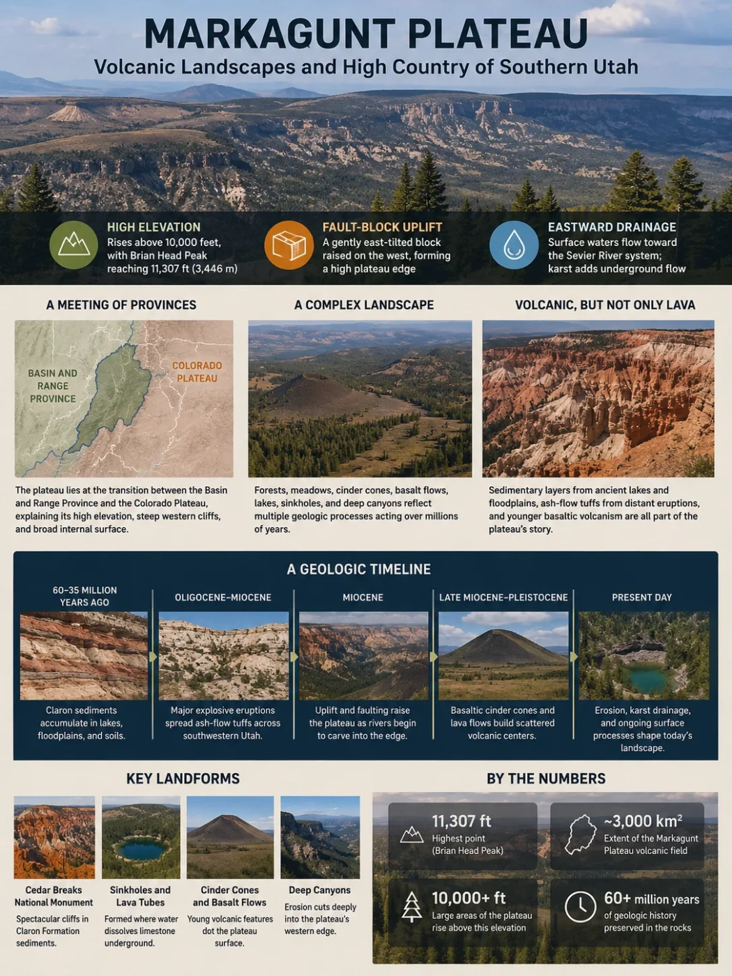
The Markagunt Plateau is a high, forested upland in southwestern Utah where fault-driven uplift, ancient lake sediments, enormous volcanic landslides, cinder cones, young basalt flows, sinkholes, and deeply eroded cliffs overlap. Its volcanic character is unmistakable, but the plateau was not built by a single episode of lava accumulation. Its present surface records several very different geologic systems acting on the same elevated block of crust.
A High Plateau at Utah’s Geologic Transition
The Markagunt Plateau rises east of Cedar City across parts of Iron, Garfield, and Kane Counties. It belongs to the High Plateaus region of southwestern Utah and lies near the transition between the Basin and Range Province to the west and the Colorado Plateau to the east. That position helps explain why its western margin can rise abruptly above lower country while much of the interior forms a broad high surface.
The plateau is structurally much simpler than its surface scenery suggests. Geologic mapping describes much of it as a gently east-tilted fault block. Its western side has been raised relative to the adjoining lowlands, while erosion has cut into the elevated edge. Brian Head Peak, on the western part of the plateau, reaches 11,307 feet (3,446 m), the highest mountain in southwestern Utah.
Brian Head and Cedar Breaks occupy the high, sharply eroded side overlooking lower Basin and Range terrain.
Forests, meadows, cinder cones, basalt flows, shallow valleys, lakes, and sinkholes occupy the elevated surface.
The gently tilted surface feeds drainage toward the Sevier River system, although underground flow complicates the watershed pattern.
Plateau and Volcanic Field Are Not the Same Boundary
The USGS defines the Markagunt Plateau volcanic field as an area of about 3,000 km² (1,160 mi²). That figure describes the mapped volcanic field, not a definitive measurement of the entire geographic plateau. The two terms overlap but should not be treated as interchangeable area measurements.
Why Markagunt Is More Than a Lava-Built Plateau
Calling Markagunt simply a volcanic plateau hides much of its history. The elevated landform has a structural foundation shaped by faulting and uplift, sedimentary rocks inherited from much older landscapes, thick volcanic deposits from distant and local eruptions, and younger basaltic centers scattered across the surface.
The colorful sedimentary rocks exposed around Cedar Breaks belong mainly to the Claron Formation. They formed as sediments accumulated in lakes, ponds, floodplains, and related environments tens of millions of years before the youngest Markagunt lava flows appeared. Limestone-rich layers, marl, sandstone, and other sediments later became important not only to the plateau’s cliffs but also to its unusual underground drainage.
Later volcanic history also came in more than one form. Some older volcanic rocks near Brian Head originated in large explosive systems far to the west near the Utah-Nevada border. Much younger activity on the plateau produced comparatively small basaltic cinder cones and lava flows. The result is a landscape in which rocks created by distant explosive eruptions can occur near landforms made by local basaltic eruptions millions of years later.
The Geologic Sequence Behind the Modern Surface
Claron Sediments Accumulate
Lake, floodplain, and soil environments left the carbonate-rich and iron-stained deposits that now form much of the pink, red, orange, and white rock exposed around Cedar Breaks.
Large Explosive Eruptions Cover the Region
Ash-flow tuffs and other volcanic material spread across southwestern Utah from major volcanic centers, including calderas west of the present plateau.
A Volcanic Landscape Collapses
The Markagunt gravity slide moved an enormous mass of volcanic rock southward, leaving displaced and deformed rocks across and beyond parts of the plateau.
The Plateau Rises Above the Western Lowlands
Fault movement raised the Markagunt block relative to country farther west. Erosion then began cutting aggressively into its elevated western margin.
Basaltic Volcanism Reshapes the High Country
Many separate vents produced cinder cones and lava flows. Some of the youngest flows are interpreted as probably Holocene in age.
This sequence explains why a single origin label is inadequate. Uplift created the regional high ground; volcanism repeatedly modified it; erosion, groundwater, ice, and mass movement reshaped what remained.
The Cinder-Cone and Lava-Flow Landscape
The young volcanic field is dominated by basaltic activity rather than one large central volcano. USGS mapping describes roughly 40 to 50 cinder cones and associated flows across the approximately 3,000 km² volcanic field. Many represent monogenetic activity: magma reached the surface at a local vent, produced a relatively short-lived eruptive center, and did not develop into a long-lived stratovolcano.
The mapped volcanic history is separated into several broad eruptive episodes, beginning about 5.3 million years ago and continuing into the late Quaternary. The youngest group includes unusually fresh-looking basalt around Dry Valley and Panguitch Lake. Some flow fronts are 30 to 60 m (100 to 200 ft) high, preserving steep, blocky margins that remain conspicuous in the modern terrain.
The Youngest Eruption Is Not Precisely Dated
The field is listed as having Holocene volcanism, and some of its freshest lava flows are considered probably Holocene. This supports describing Markagunt as a geologically young volcanic field, but it does not justify assigning an exact calendar year to its last eruption.
Hancock Peak Shows How a Cone Becomes Part of the High Country
Hancock Peak is a useful example because its volcanic origin remains identifiable even though forest now covers much of the landform. The cinder cone reaches 10,598 feet and its cone-and-lava system is estimated to be about 600,000 years old. Engelmann spruce and quaking aspen now occupy terrain created by the eruption, showing how older volcanic surfaces can become integrated into a mature mountain forest.
The contrast with younger lava is important. Fresh basalt can remain rough, blocky, and thinly vegetated, while older flows accumulate soil and support dense vegetation. A forested ridge on Markagunt can therefore conceal a volcanic surface that is much easier to recognize on a younger neighboring flow.
Present Volcanic Threat
The Markagunt Plateau Volcanic Field remains within the area monitored by the Yellowstone Volcano Observatory for young volcanoes of the Intermountain West. Its current USGS threat classification is Low to Very Low. Threat classification combines volcanic hazards with the exposure of people and infrastructure; it is not a prediction that an eruption is imminent.
How Lava Helped Create Navajo Lake
One of Markagunt’s clearest examples of volcanism changing an existing landscape occurs at Navajo Lake. A lava flow entered and blocked an older drainage valley, impounding water behind the volcanic barrier. The resulting lake therefore owes its position not simply to a basin in the plateau surface, but to the interaction between an older valley and later volcanic activity.
Surface drainage crossed the southern part of the plateau before the lava obstruction formed.
Basalt moved into the valley and created a natural barrier across the former surface-water route.
The blocked valley became the setting for Navajo Lake.
Sinkholes and soluble carbonate rocks allowed part of the drainage system to shift underground.
This last step makes Navajo Lake more unusual than a simple lava-dammed lake. Beneath and around the volcanic terrain lies the carbonate-rich Claron Formation. Water can dissolve its limestone and marl, enlarge fractures, and enter sinkholes rather than following only surface channels.
Where Surface Water Disappears Into the Plateau
Sinkholes and collapse features are common in parts of the Claron Formation. Around Navajo Lake, water entering Navajo Sinks moves through an underground system developed in soluble rock. The known cave route toward Cascade Falls extends a little more than a mile beneath the southeastern end of the lake before reaching the Pink Cliffs escarpment.
The underground connections are not based only on the appearance of the terrain. Hydrologic investigations using controlled releases, spring-discharge measurements, water chemistry, and tracer dye demonstrated connections between Navajo Sinks and springs on different sides of the local surface-water divide.
Navajo Lake water reaches sinkholes developed in the Claron Formation.
Underground flow emerges at Cascade Spring and Cascade Falls, feeding the North Fork of the Virgin River.
Another underground connection reaches Duck Creek Spring; farther downstream, water can sink again and reappear within the Sevier River drainage system.
The result is a plateau where the surface watershed and groundwater watershed do not perfectly match. Water that appears to belong to one surface basin can cross beneath the topographic divide through karst conduits. The volcanic dam at Navajo Lake and the soluble rocks beneath it therefore work together: lava obstructed an old surface route, while limestone and marl provided new routes underground.
Cedar Breaks Exposes the Western Edge of the Plateau
Cedar Breaks National Monument occupies the western rim of the Markagunt Plateau, where erosion has cut a large amphitheater into the elevated margin. The rim lies around 10,400 feet in places, with Brian Head rising farther north. The cliffs reveal the plateau’s layered sedimentary and volcanic history far more clearly than the forested interior does.
The amphitheater is carved mainly into the Claron Formation. Its alternating beds do not weather at identical rates, while joints provide pathways for water. Chemical dissolution weakens carbonate-rich rock, freezing water widens fractures, and gravity removes loosened material. Headward erosion by the Ashdown Creek drainage continues to cut into the plateau margin.
This is why Cedar Breaks should not be treated as a model for the entire Markagunt surface. Its cliffs, fins, pinnacles, and hoodoos represent an eroding plateau edge. Farther inland, broad uplands, forest, lakes, shallow valleys, volcanic cones, and lava surfaces can dominate instead.
Old Lava Flows Can Become Ridges Instead of Valleys
Some of Markagunt’s older lava flows preserve an apparent reversal of topography known as inverted relief. Geologic mapping around the central plateau and Panguitch Lake documents classic inverted valleys capped by lava.
A Valley Carries Lava
Basalt follows low ground because the valley offers an easy downhill path.
The Lava Hardens
The flow creates a resistant cap of volcanic rock along the old valley floor.
Surrounding Rock Erodes
Less resistant terrain beside the lava surface is lowered more quickly over long periods.
The Old Valley Becomes High Ground
The resistant lava remains as a ridge or elevated bench, preserving the position of a drainage route that once occupied the lowest terrain.
Inverted valleys are especially useful for reading the plateau because they show that present elevation alone does not reveal the original landscape. A basalt-capped ridge may record the position of an ancient valley rather than an old topographic high.
The Markagunt Gravity Slide Records a Far Larger Volcanic Collapse
The scattered cinder cones visible today represent only one scale of volcanic activity in the region. Much older rocks preserve evidence for a completely different event: the catastrophic failure of part of the ancient Marysvale volcanic field about 21 to 22 million years ago. The resulting feature is known as the Markagunt gravity slide.
Early mapping recognized displaced volcanic rocks on the plateau as the Markagunt Megabreccia. Later work traced related deformation much farther outward. Utah Geological Survey mapping eventually estimated the full Markagunt gravity slide at at least 2,000 square miles, extending well beyond the plateau itself and placing it among the largest terrestrial landslides recognized on Earth.
The distinction between the Megabreccia and the broader gravity slide matters. Megabreccia describes chaotic and displaced rock that helped geologists recognize the event on Markagunt. The later gravity-slide interpretation connects those plateau exposures with a much larger collapse structure extending across southwestern Utah.
Large slabs moved over a relatively weak basal zone associated with volcaniclastic rocks. Some internal blocks remained surprisingly intact, while other areas were intensely broken, folded, faulted, or pulverized. Research supports rapid catastrophic emplacement rather than ordinary slow hillside creep. The exact trigger remains less certain than the existence and scale of the slide itself; proposed mechanisms involve instability within the ancient volcanic field and associated intrusive activity.
Why the Markagunt Surface Is Not Simply Flat
The plateau’s identity comes from its broad regional elevation above surrounding terrain, not from a uniformly level surface. Volcanic cones rise above the upland, lava fronts create abrupt local relief, shallow valleys cross gently sloping areas, sinkholes interrupt drainage, and erosion cuts deeply into the western and southern margins.
The contrast is especially clear between the plateau interior and Cedar Breaks. On the interior, the underlying fault block can retain broad high surfaces despite local volcanic and erosional features. Along the western rim, the same elevated landmass has been deeply attacked by streams, frost action, dissolution, landsliding, and mass wasting.
Markagunt is therefore better understood as a high, structurally elevated plateau with a volcanic and erosional overprint than as a perfectly flat lava table. That description also explains why neighboring parts of the same plateau can look like forested mountain country, a young lava field, a karst basin, or a cliff-cut amphitheater.
Glacial Traces Survive on the Highest Ground
Volcanism and karst are not the only younger processes recorded on Markagunt. High parts of the plateau supported alpine glaciers during Pleistocene cold periods. The Crystal and Lowder Creek basins east of Brian Head contain the southernmost documented glacial deposits in Utah. Moraines and hummocky terrain preserve evidence of former ice even where dramatic glacially carved bedrock forms are limited.
Glacial and periglacial processes also modified the Cedar Breaks area. Today, the same high elevation continues to favor long periods of snow cover, repeated freezing and thawing, and strong seasonal snowmelt. Those processes connect the plateau’s highest terrain to both its cliff erosion and its groundwater system: snow supplies water, fractures and sinkholes provide entry points, and soluble rocks allow part of that water to move beneath the visible landscape.