INTERACTIVE CONTEXT MAP
Where is Mysore Plateau?
The selected plateau and nearby mapped locations are shown. Open the full world atlas to explore every region.
Southern India’s Crystalline Upland
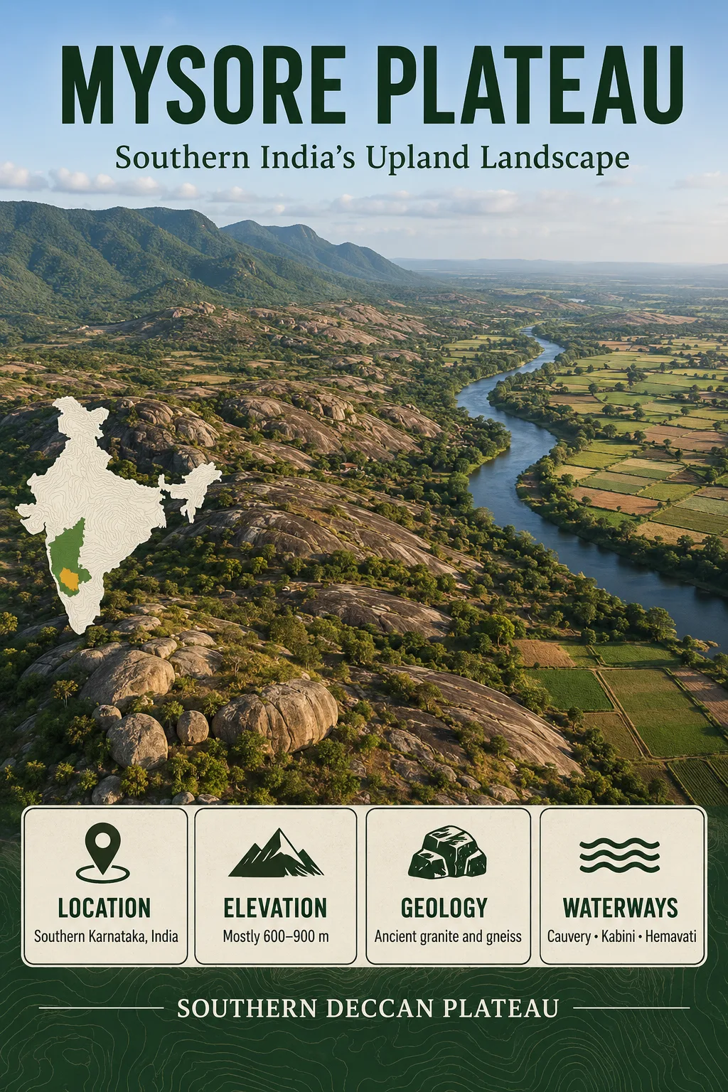
The Mysore Plateau is a broad, rolling upland across southern Karnataka, shaped on ancient crystalline rocks and organized by the Cauvery river system. Much of its surface is neither flat nor sharply mountainous: weathered plains, granite hills, shallow valleys and isolated rocky uplands form a landscape that changes from the wetter Western Ghats margin to the drier interior and east.
Dharwar Craton
Rolling Crystalline Terrain
Cauvery Drainage
The Mysore Plateau Is a Physiographic Region, Not a Fixed Boundary
The name Mysore Plateau refers to a physical landscape rather than an administrative unit. It extends across much of southern Karnataka and forms the southern part of the larger Karnataka Plateau. Its limits are therefore better understood through changes in relief, geology and drainage than through a single boundary line.
To the west, the plateau approaches the much steeper terrain of the Western Ghats and the humid Malnad. Toward the south, upland surfaces meet the Nilgiri region and other elevated blocks near the Karnataka–Tamil Nadu transition. To the east and southeast, the terrain becomes progressively more dissected toward hill systems associated with the Eastern Ghats. Its northern transition into the wider Karnataka interior is more gradual.
Boundary Note
Published definitions do not always draw the Mysore Plateau at exactly the same scale. Some use the name for the South Karnataka Plateau, while broader geological descriptions may apply it to a larger part of the southern Dharwar cratonic terrain. Area figures should therefore be read together with the definition being used.
Mysuru lies within this upland, but the plateau is much larger than Mysuru city or Mysuru district. Bengaluru, Mandya, Hassan and several surrounding districts also occupy or intersect parts of the wider plateau landscape.
From Malnad to Maidan, the Landscape Changes Across the Upland
One of the most useful ways to understand the Mysore Plateau is through the traditional contrast between Malnad and Maidan. These are not two sharply separated geological plates. They describe a broad transition in relief, rainfall, vegetation and land use.
Higher rainfall, steeper valleys, greater forest cover and stronger relief near the Western Ghats.
Rolling uplands, pediplains, cultivated surfaces, low granite hills and broad shallow valleys.
Generally drier terrain with stronger seasonal water limits and locally dissected rocky hills.
The western part is influenced directly by the rise of the Western Ghats, where moist air from the Arabian Sea produces much heavier rainfall. Moving inland, the landscape becomes more open and less deeply forested. The Maidan is characterized especially well by rolling plains interrupted by low rocky hills, rather than the steep mountain relief of the Ghats.
This west-to-east transition helps explain several other features of the plateau at once: vegetation becomes less humid, rain-fed farming becomes more important, groundwater stress can become more noticeable, and rivers increasingly function as concentrated corridors of water through a seasonally dry upland.
A Crystalline Plateau Rather Than a Deccan Trap Lava Field
The Mysore Plateau belongs to the ancient geological core of peninsular India. Much of it is underlain by rocks of the Dharwar Craton, including Peninsular Gneiss, granitic bodies, greenstone and schist belts, amphibolitic rocks and, toward parts of the southern cratonic margin, higher-grade metamorphic rocks such as granulites.
This matters because the term Deccan Plateau can create a misleading picture. The famous Deccan Traps of Maharashtra and adjoining areas are dominated by enormous successions of flood basalt. The Mysore Plateau is largely different: its characteristic upland surface has developed across much older crystalline basement.
| Landscape Trait | Mysore Plateau | Northwestern Deccan Trap Region |
|---|---|---|
| Dominant geological foundation | Ancient gneiss, granite, schist, greenstone and related crystalline rocks | Thick sequences of flood basalt |
| Common landforms | Rolling pediplains, granite hills, residual uplands, rock outcrops and broad weathered surfaces | Lava-controlled plateaus, scarps, mesas and step-like basalt terrain |
| Common soil associations | Red loamy or sandy soils, ferruginous soils and local lateritic surfaces | Black clay-rich soils are widespread over many basaltic areas |
| Groundwater behavior | Strongly dependent on weathered rock and fractures | Stored in weathered, fractured and locally vesicular basalt zones |
The comparison does not mean every part of either region looks the same. It explains why a generalized image of the Deccan as a dark-basalt tableland does not accurately describe southern Karnataka.
Ancient Bedrock Does Not Mean an Unchanged Ancient Surface
Some rocks beneath the Mysore Plateau are more than three billion years old, but the visible land surface should not be assigned the same age. The present relief reflects a much longer sequence of weathering, erosion, stripping of weathered material, drainage development and renewed river incision.
Gneisses, granites and associated Dharwar rocks form the structural foundation.
Long exposure altered the upper rock into weathered mantles of varying thickness.
Erosion reduced broad areas to low-relief pediment and pediplain surfaces while resistant rocks remained higher.
Cauvery tributaries cut valleys and locally exposed resistant bedrock, producing the modern rolling and dissected relief.
Recent geomorphic work in the upper Cauvery basin describes broad low-gradient valleys, subdued relief and relict surfaces across the plateau. Pediment–pediplain complexes are especially important around the Cauvery, Hemavati, Shimsha and Arkavati systems.
These old erosion surfaces also help explain why deeply weathered ground can occur beside bare granite or resistant rocky hills. Erosion has not lowered every rock type at the same rate.
Why the Plateau Looks Rolling Instead of Flat
A plateau is an elevated region, not necessarily a flat-topped table. The Mysore Plateau demonstrates this distinction particularly well. Much of the interior consists of undulating or rolling terrain in which low divides rise gently between drainage lines.
Several landforms repeatedly occur within this terrain:
- Pediplains form broad, low-relief surfaces produced through long-term weathering and erosion.
- Pediments occur as gently inclined rock or thinly covered surfaces near hill bases.
- Residual hills remain where more resistant rock has survived surrounding erosion.
- Inselbergs and rocky knobs rise abruptly from some otherwise subdued surfaces.
- Granite domes, boulder slopes and tors occur where jointed granitic rocks have been exposed by weathering and stripping.
- Valley fills occupy some lower positions where weathered sediment has accumulated.
Chamundi Hill near Mysuru is a familiar example of local high ground rising well above the surrounding plateau surface. Similar contrasts between rocky hills and lower weathered plains occur across southern Karnataka.
Much of the main upland is commonly described in the range of roughly 700–900 metres above sea level, although broader definitions of the South Karnataka Plateau include surfaces closer to 600 metres. Local hills rise much higher. A single average elevation therefore hides much of the actual terrain.
Elevation Is Not One Surface
Bengaluru occupies a comparatively high part of the upland, while Mysuru lies on a lower rolling surface. Residual hills and surrounding mountain blocks may stand hundreds of metres above nearby plains, so city elevations, plateau-surface elevations and summit elevations should not be treated as interchangeable measurements.
The Cauvery Organizes the Plateau’s Drainage
The Cauvery River is the dominant drainage system across much of the southern plateau. It begins in the Brahmagiri hills of the Western Ghats and moves from the wetter western highlands into the interior upland before continuing toward Tamil Nadu.
Across the plateau, the main river is joined by tributary systems including the Hemavati, Harangi, Kabini, Lakshmana Tirtha, Shimsha and Arkavati. Together they collect runoff from landscapes with very different rainfall conditions, from humid Ghats headwaters to drier interior catchments.
High-rainfall source areas feed the upper Cauvery and several major tributaries.
The river network crosses rolling crystalline terrain and gathers tributaries from broad inland catchments.
The Cauvery leaves the Karnataka upland toward lower terrain in Tamil Nadu.
The widespread eastward drainage is related to the broader easterly inclination of peninsular India. Elevation alone does not make every channel direct or uniform; local rock structures, resistant ridges and long-established drainage courses create bends, islands, narrow passages and abrupt changes in river gradient.
Srirangapatna and the Divided Channel
Near Srirangapatna, the Cauvery divides around an island before its channels rejoin downstream. The feature is part of the river’s passage across the bedrock-controlled plateau rather than a separate lowland river environment.
Shivanasamudra and the Break in Gradient
Farther downstream, the Cauvery divides again around Shivanasamudra and descends through a series of falls and rapids. The total drop is commonly reported at about 91 metres. The waterfalls expose an important characteristic of plateau rivers: a channel may meander across a relatively subdued upland and then encounter a much sharper bedrock-controlled descent.
The Western Ghats Create a Strong Moisture Gradient
Climate across the Mysore Plateau cannot be described well with one rainfall figure. The Western Ghats intercept moisture-bearing winds from the Arabian Sea, creating wet conditions along the western highlands and a marked reduction in rainfall farther inland.
The result is a broad transition from humid and heavily vegetated terrain near the Ghats to drier interior uplands. The Cauvery basin itself passes through several moisture regimes rather than one uniform tropical climate.
The southwest monsoon supplies much of the rain across western and central parts of the plateau. Toward the eastern and southeastern basin, rainfall from the later northeast monsoon becomes relatively more important. Local elevation and exposure modify this general pattern.
This rainfall gradient is closely tied to the physical geography of the plateau. It influences vegetation density, stream seasonality, soil moisture, crop choice and the amount of pressure placed on tanks, reservoirs and groundwater.
Hard Crystalline Rock Controls How Groundwater Is Stored
Granite and gneiss are often described as hard-rock aquifers. Fresh crystalline rock has little primary pore space compared with many sedimentary rocks, so groundwater is not distributed evenly through the bedrock.
Water is stored mainly where weathering and structural breaks have created usable space. A typical groundwater system can include a weathered upper mantle, more intensely fractured rock beneath it and deeper joints or shear zones that may transmit water.
Decomposed rock near the surface can hold and slowly release groundwater where sufficient thickness has developed.
Joints, fractures and shear zones provide secondary openings through otherwise dense crystalline rock.
Low-relief weathered surfaces and some valley fills can offer better recharge conditions than bare structural hills or rocky residual uplands.
This produces strong local variation. Two boreholes drilled relatively close together can encounter different fracture networks and therefore very different yields. Topography also matters: exposed hills tend to shed runoff, while weathered depressions, pediplains and valley zones may favor infiltration where soil, fractures and drainage conditions permit it.
The relationship remains relevant in current groundwater assessments of Karnataka, where gneissic complexes, granites, schists and related hard-rock units continue to be treated as distinct aquifer systems rather than as one uniform underground reservoir.
Soils Reflect Both Bedrock and Position in the Landscape
Red soils are widespread across much of the Mysore Plateau, particularly over weathered granitic and gneissic terrain. Their color commonly reflects iron compounds produced during prolonged chemical weathering. Sandy and loamy textures occur widely, while local lateritic surfaces record more intense weathering and leaching.
Soil characteristics also change with slope position. Thin or stony soils can occur on resistant uplands and rocky hills. Deeper weathered profiles are more likely on stable low-gradient surfaces, while finer material can accumulate in valley bottoms and other lower positions.
This is why a simple description such as “red soil plateau” is incomplete. The visible soil pattern is connected to rock type, weathering depth, drainage, relief and rainfall, all of which vary across the upland.
Tanks and Reservoirs Compensate for Uneven Water Availability
The combination of seasonal rainfall, hard-rock aquifers and large cultivated uplands has made surface-water storage especially important across southern Karnataka. Tank irrigation has a long history in the region, with small reservoirs and connected local water bodies storing monsoon runoff for later use.
These local systems operate at a different scale from the major reservoirs built on the Cauvery and its tributaries. The Krishna Raja Sagara, Kabini, Hemavati and Harangi reservoirs store much larger volumes and influence irrigation and water supply across broad parts of the basin.
Why Storage Matters Here
A hard-rock plateau can receive substantial seasonal rain without storing that water evenly underground. Surface reservoirs, tanks, soil moisture and fractured aquifers therefore function as different parts of the same regional water system.
Reservoirs do not erase the underlying rainfall gradient. Irrigated corridors can have water-intensive agriculture even where nearby uplands remain much more dependent on rainfall or groundwater.
Agriculture Changes With Relief, Rainfall and Access to Irrigation
The plateau does not support one uniform agricultural landscape. In drier interior uplands, crops suited to seasonal rainfall and lower water availability have traditionally included ragi, pulses and oilseeds. Irrigation changes the pattern considerably.
Along the Cauvery system, especially in parts of Mandya and adjoining districts served by major irrigation works, paddy and sugarcane can occupy landscapes that would otherwise face much stronger seasonal moisture limits. Valleys and irrigated plains therefore look very different from nearby rocky or rain-fed uplands.
Toward the wetter western transition, greater rainfall and cooler elevated conditions allow different cropping and vegetation patterns. The agricultural map of the plateau is consequently another expression of the same west-to-east physical gradient seen in rainfall and natural vegetation.
Bengaluru and Mysuru Occupy Different Parts of the Same Upland
Two of southern Karnataka’s largest cities provide useful reference points for the plateau’s uneven surface. Bengaluru occupies a relatively high eastern part of the South Karnataka upland, while Mysuru lies farther southwest on a lower rolling surface associated with the Cauvery–Kabini region.
Bengaluru also lies across multiple shallow drainage divides. Its historic chains of lakes and tanks developed within small plateau catchments rather than beside a single major river flowing through the city. The physical setting differs from settlements situated directly along the Cauvery and its larger tributaries.
Mysuru, by contrast, lies much closer to the Cauvery system and to prominent residual relief such as Chamundi Hill. These differences show why the Mysore Plateau should not be imagined as one level bench extending across southern Karnataka.
The Plateau Ends Through Transitions, Scarps and Higher Blocks
The Mysore Plateau is surrounded by stronger relief, but the nature of its margins varies. The western side approaches the Western Ghats, where valleys deepen and elevations rise sharply. The southern edge meets highland terrain associated with the Nilgiris and adjoining structural blocks. To the southeast and east, isolated ranges and dissected hills create a more complex transition toward the Eastern Ghats region.
These margins also affect rivers. Streams that occupy broad, mature valleys across parts of the interior can enter narrow bedrock passages, rapids or waterfalls where gradients steepen. The contrast between subdued plateau surfaces and rugged edges is therefore visible not only in hills but also in river profiles.
The boundaries are best understood as physiographic transitions. A precise line appropriate for an administrative map would give a false sense of certainty for a landscape whose definition changes slightly between geomorphic, geological and regional classifications.
Mysore Plateau, Mysuru Plateau and Karnataka Plateau Are Not Perfect Synonyms
Mysore Plateau remains the established geographic term in much English-language physical geography and geology. Mysuru is the current official spelling of the city historically called Mysore, so “Mysuru Plateau” may also appear, but changing the city name has not removed the older geographic term from scientific use.
South Karnataka Plateau is often used for broadly the same southern physiographic region, especially when distinguishing it from the North Karnataka Plateau. In this usage, Mysore Plateau is a subdivision of the wider Karnataka Plateau.
| Term | Typical Meaning | Important Distinction |
|---|---|---|
| Mysore Plateau | The established name for the southern Karnataka upland | Not limited to Mysuru city or district |
| Mysuru Plateau | A modern-spelling variant occasionally used for Mysore Plateau | Less established in older geographic and geological literature |
| South Karnataka Plateau | A physiographic name for the southern section of the Karnataka Plateau | Often overlaps strongly with what is called the Mysore Plateau |
| Karnataka Plateau | A broader plateau region that can include northern and southern sections | Should not automatically be treated as identical to the narrower Mysore Plateau |