INTERACTIVE CONTEXT MAP
Where is Patagonian Plateau?
The selected plateau and nearby mapped locations are shown. Open the full world atlas to explore every region.
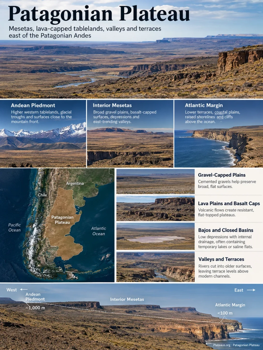
The Patagonian Plateau is the broad tableland landscape east of the Patagonian Andes in Argentina, but it is not one level, unbroken slab of high ground. It is better understood as a system of mesetas, stepped gravel surfaces, lava-capped tablelands, broad depressions, river terraces and glacially modified plains that generally descend toward the Atlantic. That layered relief explains why Patagonia can look almost level across a distant horizon while containing deep valleys, abrupt escarpments and isolated high plateaus at closer range.
A Plateau Made of Stepped Mesetas
The Spanish term meseta is especially useful in Patagonia because the regional plateau is divided into many table-like surfaces rather than forming one continuous topographic bench. Across Extra-Andean Patagonia, broad structural plains and lava plains alternate with lower basins and river corridors. Many gravel-covered surfaces descend gradually from west to east, and some terminate near the Atlantic as high coastal cliffs.
Higher western tablelands, glacial troughs and surfaces close to the mountain front.
Broad gravel plains, basalt-capped surfaces, depressions and east-trending valleys.
Lower terraces, coastal plains, raised shorelines and cliffs above the ocean.
This west-to-east arrangement is not a uniform slope. Individual mesetas can stand well above nearby basins, and volcanic plateaus in western or northern Patagonia may reach elevations far greater than the stepped gravel surfaces nearer the coast. In southern Santa Cruz, for example, a studied Extra-Andean tableland falls from average elevations near 1,000 m at the Andean piedmont to less than 100 m near the Atlantic. That profile describes one sector, not a single elevation for the entire Patagonian Plateau.
Boundary Note
Patagonian Plateau is a broad physiographic label rather than a sharply surveyed administrative unit. Argentine geomorphology often uses Extra-Andean Patagonia for the extensive terrain east of the Patagonian Cordillera, a region that includes several geological massifs, sedimentary basins and meseta systems. Area figures therefore depend on which of those margins a source includes.
Flat at Regional Scale, Broken at Ground Level
A plateau can be relatively level when viewed across tens of kilometres and still contain strong local relief. Patagonia is a good example. Its characteristic horizontal skylines are interrupted by scarps, volcanic cones, dry depressions, cañadones, broad valleys and terrace steps. The result is a landscape that is plateau-like at regional scale but far from featureless.
Structural Surfaces
Gravel-Capped Plains
Many mesetiform surfaces carry cemented gravels derived from river, piedmont, pediment or glaciofluvial deposits. Resistant surface layers help preserve broad benches while adjacent terrain is lowered by erosion.
Volcanic Relief
Lava Plains and Basalt Caps
Large basalt flows cover parts of Patagonia. Where basalt protects softer material below, erosion can leave flat-topped plateaus, benches and resistant ridges standing above nearby lowlands.
Negative Relief
Bajos and Closed Basins
Low depressions interrupt the tablelands. Some have internal drainage and may contain temporary lakes, saline flats or wetlands rather than an outlet to the sea.
Dissection
Valleys and Terrace Staircases
Rivers have cut into older plateau surfaces and left former floodplain or valley-floor levels stranded as terraces above modern channels.
The Plateau Did Not Form in a Single Geological Event
No single process explains the Patagonian Plateau. Its present form combines old bedrock and sedimentary basins with regional uplift, repeated volcanic episodes, river incision, glaciation, wind action and coastal erosion. Different parts of the plateau preserve different combinations of those processes.
Basins, Massifs and Sedimentary Sequences
Patagonia contains old crystalline massifs as well as thick sedimentary successions deposited in continental and marine settings. These rocks form the substrate beneath many later plateau surfaces.
Uplift, Planation and Erosion
Broad surfaces were uplifted, tilted and eroded during the Cenozoic. Some old low-relief surfaces survived as high tablelands while surrounding areas were lowered or dissected.
Basalt Spread Across Selected Areas
Plateau-forming mafic volcanism occurred repeatedly from the Late Cretaceous through the Cenozoic and into much younger episodes. The lava fields do not share one age or one tectonic origin.
Ice, Rivers, Wind and the Atlantic Margin
Glaciers deeply modified western and southern tablelands, rivers cut transverse valleys, wind reworked exposed sediment, and changing sea levels left raised coastal forms along the Atlantic edge.
The tectonic history is also more complex than a simple story of the Andes pushing the plateau upward. Models of southern Patagonia support broad Cenozoic rock uplift, and recent work has linked part of the long-wavelength uplift there to mantle and slab-window processes associated with the evolving plate boundary west of Patagonia. That interpretation applies to regional topographic evolution; it does not mean every meseta formed by the same mechanism.
Basalt Caps Can Turn Old Low Ground Into High Ground
Volcanic rocks explain some of the most distinctive tablelands, but calling the whole Patagonian Plateau a volcanic plateau would be too broad. Basalt is widespread in particular sectors, where resistant lava sheets protect underlying rock from erosion. In places, the effect goes one step further: an old valley can become a modern ridge.
Low ground channels water across an older landscape.
Fluid basalt follows the existing depression and solidifies as a resistant strip.
Weathering and erosion lower the older rocks beside the basalt more rapidly.
The former low route survives as a ridge or elevated bench above the younger landscape.
Somuncurá’s elevated volcanic tablelands in northern Patagonia provide a clear example. It is a broad basaltic plateau with lava-covered surfaces, closed depressions and poorly integrated drainage. Long, winding resistant lava bodies in parts of the plateau preserve former drainage paths as elevated ridges, a textbook expression of topographic inversion.
Three Landscapes Show Why One Plateau Profile Is Not Enough
Meseta de Somuncurá
Straddling Río Negro and Chubut, Somuncurá rises to around 1,000 m across broad sectors and is dominated by basaltic surfaces. Closed basins, saline depressions, volcanic relief and inverted topography make it a strong northern example of how lava and erosion can preserve a meseta.
Meseta del Lago Buenos Aires
This basaltic plateau in northwestern Santa Cruz covers roughly 5,000 km² and has a broad surface near 1,400 m above sea level. More than 100 scoria-cone vents rise from the plateau, while later erosion and glaciation have strongly modified its margins. Extensive tholeiitic lava caps there were emplaced roughly 11–7 million years ago, followed by younger volcanic activity.
Southern Santa Cruz Tablelands
Farther south, sedimentary and volcanic tablelands slope gently toward the Atlantic and retain widespread glacial and glaciofluvial landforms. Moraine belts, outwash plains, meltwater channels and erratic boulders show how far former piedmont glaciers extended beyond the Andes.
These examples are parts of the wider Extra-Andean landscape, not interchangeable names for the Patagonian Plateau itself. Their contrasting elevations and origins are exactly why a single “average plateau height” hides more than it explains.
Rivers Cut Across the Eastward-Sloping Surface
The plateau is crossed by broad fluvial corridors that break the continuity of the mesetas. Major river systems and valley networks include the Colorado, Negro, Chubut, Senguer, Deseado and Santa Cruz. Their floodplains, abandoned channels and terrace levels occupy large areas within otherwise dry tableland terrain.
Several valleys trend broadly eastward, linking Andean or interior catchments with lower Extra-Andean terrain and, in many cases, the Atlantic. As rivers incised, older valley floors remained above the active channel as terraces. A cross-section can therefore show a high plateau surface, a lower terrace bench and the modern floodplain stacked one below another.
The broad regional surface remains highest.
A former river or valley level is left above the modern channel.
Present drainage occupies the lowest active corridor.
Glaciers Reworked the Western and Southern Tablelands
Glaciation is essential to understanding the western and southern Patagonian Plateau. Former ice did not remain inside the present mountain belt. Piedmont glaciers repeatedly spread eastward onto Extra-Andean terrain, leaving tills, moraines, outwash plains and meltwater channels across tableland surfaces.
South of Lago Viedma, late Pliocene glaciers reached at least about 80 km east of the Andean crest. Later Pleistocene ice became more focused into valleys and cut deeply into the older landscape. In that sector, modern valley floors can lie as much as about 1,350 m below remnants of the late Pliocene surface. The present relief therefore preserves both an older elevated tableland and the deep troughs cut into it.
This glacial imprint becomes especially prominent toward southern Santa Cruz. It should not be used to classify the entire Patagonian Plateau as a glacial plateau; instead, glaciation is one of the later processes that reworked pre-existing sedimentary and volcanic tablelands.
The Andes Create the Dry Side of Patagonia
The plateau’s dry climate is closely tied to its position east of the Andes. Moist westerly air from the Pacific rises over the mountain chain, cools and loses much of its moisture on the windward side and at high elevations. Air descending into Argentina is drier, creating a strong rain-shadow effect across Extra-Andean Patagonia.
Moist air approaches Patagonia from the west.
Air rises over the mountains, cools and produces much of its precipitation.
Drier air descends east of the crest and warms.
Semi-arid steppe and exposed sediment dominate much of the Extra-Andean surface.
Strong westerly winds then act on a landscape with sparse plant cover. Wind can move fine sediment and dust, strip material from dry depressions and saline lake beds, and reinforce the open appearance of the steppe. The wind is an active surface process, but it did not create the plateau itself.
Vegetation follows the moisture pattern rather than covering the tablelands evenly. Shrubs, grasses and other drought- and wind-tolerant plants dominate large areas, while mallines form wetter meadow-like patches where groundwater, shallow depressions or stream corridors keep soils moist. Those green patches can be small compared with the surrounding steppe but mark important hydrological contrasts in the plateau landscape.
The Atlantic Edge Records Both Erosion and Uplift
At the eastern margin, the descending tablelands meet the Atlantic through coastal plains, marine terraces and cliffs. Some stepped gravel surfaces end in cliffs more than 100 m above the sea, while lower raised shorelines preserve evidence of former sea levels.
Quaternary marine terraces occur along long stretches of the Patagonian coast. They formed through repeated interaction between sea-level highstands, wave erosion, sediment deposition and vertical movement of the land. Some older coastal features occur at elevations approaching 180 m, while younger Holocene beach ridges and littoral terraces lie much closer to present sea level.
The raised coast is also part of the early scientific history of Patagonian geomorphology. Charles Darwin noticed elevated coastal plains and marine shells during the Beagle voyage and used them as evidence that parts of the coast had risen relative to the sea. Modern dating and mapping have refined that observation by separating shoreline generations of different ages.
Why One Elevation or Area Figure Can Be Misleading
Measurement Note
A single elevation cannot describe the Patagonian Plateau because the regional surface steps down toward the Atlantic while individual mesetas rise well above neighboring basins. The same problem applies to area: there is no universally fixed boundary separating every Extra-Andean meseta, basin, foothill and coastal surface into one official plateau polygon.
Elevation figures are most useful when tied to a named place or transect. The southern Extra-Andean tablelands between the Andes and Atlantic show a broad decline from around 1,000 m to below 100 m, while the Meseta del Lago Buenos Aires has a broad surface around 1,400 m. Somuncurá provides another high northern plateau. These values describe different landform units inside the regional system, not competing measurements of one flat surface.
Area estimates require the same care. A figure for all of Patagonia, the Patagonian steppe, Extra-Andean Patagonia, a basaltic province or a specific meseta answers a different geographic question. Treating those boundaries as interchangeable can produce very different numbers under the same “Patagonian Plateau” label.
Patagonian Plateau, Steppe, Desert and Andes Describe Different Things
| Term | What It Describes | Why It Is Not a Synonym for Patagonian Plateau |
|---|---|---|
| Patagonian Plateau | A broad physiographic concept for the tablelands and meseta-dominated terrain east of the Patagonian Andes. | It refers mainly to landform and relief rather than one ecological or climatic zone. |
| Extra-Andean Patagonia | The Patagonian region east of the Cordillera, including massifs, sedimentary basins, mesetas, valleys and the coastal sector. | It is a wider and more precise regional geomorphological term in Argentine usage. |
| Patagonian Steppe | An ecological landscape dominated by dry grasslands and shrublands under cold, windy and semi-arid conditions. | Ecological boundaries do not exactly follow plateau landform boundaries. |
| Patagonian Desert | A broad climatic and landscape label used for the driest parts of Patagonia. | Aridity describes climate and vegetation; it does not define the origin or geometry of the mesetas. |
| Patagonian Andes | The mountain belt along western Patagonia, with high relief, glacial landforms and major precipitation gradients. | The Andes form the western topographic boundary and strongly influence the plateau, but they are a different physiographic system. |
| Patagonia | The much broader geographic region spanning southern South America. | Patagonia includes mountains, plateaus, steppes, coasts, islands, lakes and other landscapes beyond the plateau system. |