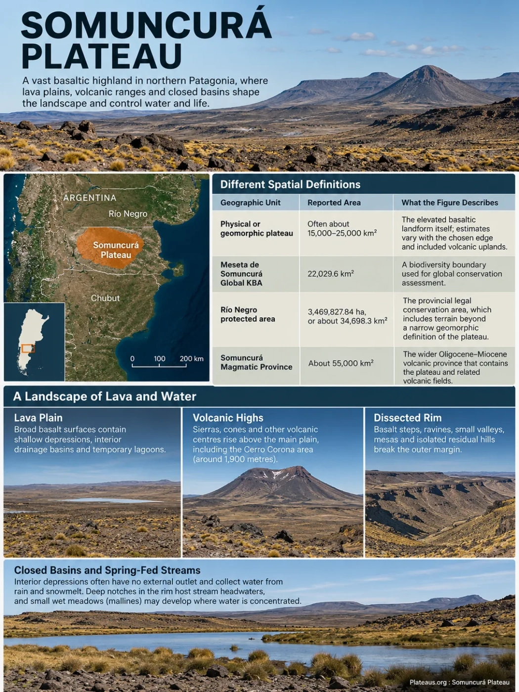
Somuncurá Plateau is a broad basaltic highland in northern extra-Andean Patagonia, centered in south-central Río Negro and extending into northern Chubut. Its lava plains, volcanic ranges, closed depressions and spring-fed streams form a landscape in which geology controls not only the shape of the plateau, but also where water appears and where some of Patagonia’s most range-restricted species survive.
Somuncurá Has More Than One Geographic Boundary
The name Somuncurá is used for several overlapping but different geographic units. The physical plateau is not the same thing as the wider Somuncurá Magmatic Province, the Global Key Biodiversity Area, or Río Negro’s legally protected area. That distinction explains why published area figures can differ by tens of thousands of square kilometres without any one figure being automatically wrong.
| Geographic Unit | Reported Area | What the Figure Describes |
|---|---|---|
| Physical or geomorphic plateau | Often about 15,000–25,000 km² | The elevated basaltic landform itself; estimates vary with the chosen edge and included volcanic uplands. |
| Meseta de Somuncurá Global KBA | 22,029.6 km² | A biodiversity boundary used for global conservation assessment. |
| Río Negro protected area | 3,469,827.84 ha, or about 34,698.3 km² | The provincial legal conservation area, which includes terrain beyond a narrow geomorphic definition of the plateau. |
| Somuncurá Magmatic Province | About 55,000 km² | The wider Oligocene–Miocene volcanic province that contains the plateau and related volcanic fields. |
Boundary Note
A single “area of Somuncurá” figure is misleading unless the boundary type is named. The plateau, the volcanic province, the biodiversity site and the protected area answer different geographic questions.
The physical plateau lies several hundred kilometres east of the active Andean volcanic arc and belongs to the wider system of stepped Patagonian tablelands. It forms a broad elevated surface in northern Patagonia rather than an Andean plateau. Río Negro contains much of the best-known high surface and the provincial protected area, while the basaltic plateau and related volcanic terrain continue southward into Chubut.
The Plateau Is a Lava Surface Broken by Volcanic Highs and Deep Margins
Somuncurá is often described as a plateau, but the surface is not uniformly flat. Large tracts rise above 1,000 metres, while volcanic mountains and sierras stand above the lava plain. Cerro Corona reaches roughly 1,900 metres and is one of the highest points associated with the plateau. Treating that summit elevation as the elevation of the entire plateau would overstate the height of most of the surface.
Broad basalt surfaces contain shallow depressions, interior drainage basins and temporary lagoons.
Sierras, cones and other volcanic centres rise above the main plain, including the Cerro Corona area.
Basalt steps, ravines, small valleys, mesas and isolated residual hills break the outer margin.
The rim is especially important for understanding the plateau’s drainage. Deep notches and ravines cut into the basalt edge, and some stream headwaters occupy these incisions. Locally, deep re-entrants in the plateau margin are known as rincones. Small wet meadows, or mallines, may develop where water is concentrated in otherwise dry terrain.
Interior depressions add another layer to the relief. Many have no external surface outlet and collect water only after rain or snowmelt. Their lagoons can therefore expand, shrink or disappear with changing water supply. The plateau is better understood as a volcanic upland containing lava plains, enclosed basins and later volcanic relief than as a single level table.
Two Oligocene Eruptive Pulses Built Most of the Basalt Plateau
Somuncurá belongs to an Oligocene–Miocene volcanic province developed over older crust of the North Patagonian Massif. The broad plateau surface was produced by repeated lava outpourings rather than by one central volcano. Geological work distinguishes two main flood-basalt pulses during the Oligocene, followed by younger volcanic activity that added smaller fields, cones and more evolved volcanic complexes.
Early Flood-Basalt Activity
An early Oligocene pulse spread mafic lava across parts of the province and began building extensive lava surfaces.
The Largest Plateau-Building Pulse
A later Oligocene pulse was broader and more voluminous. These widespread basalt flows account for much of the elevated lava plain identified with the Somuncurá Plateau.
Post-Plateau Volcanism
Younger alkaline eruptions continued after the main flood-basalt stage. Monogenetic centres and larger volcanic complexes helped create the sierras and isolated highs that now rise above the plateau surface.
The volcanic province is unusual because it developed far behind the Andean volcanic front and does not fit a simple modern hotspot model. Geochemical studies have linked the main magmatism to mantle upwelling during plate reorganization, with interaction between mantle sources and material affected by earlier subduction. The exact geodynamic mechanism remains a research topic, so the plateau is best described by the well-dated eruptive sequence rather than by a single simplified origin story.
Landform Distinction
Somuncurá is not one giant volcanic cone. The plateau is the broad product of repeated lava flows, with younger volcanic centres superimposed on the main basalt surface.
Water Moves Through the Basalt Before It Reappears at Springs
The plateau’s water system is closely tied to the physical properties of its volcanic rocks. Rain and melting snow can enter fractures, joints and porous zones in the basalt instead of remaining on the surface. Hydrogeological descriptions of Somuncurá compare the plateau to a large natural sponge: water infiltrates the lava cover, moves through the rock mass and later emerges at springs along lower slopes and margins.
Limited precipitation reaches the high lava surface, including winter snow at higher elevations.
Water enters cracks, joints and permeable parts of the volcanic cover rather than forming a dense surface river network.
Groundwater returns to the surface at springs and helps sustain small valleys, mallines and stream headwaters.
Many channels are temporary, while interior depressions retain water in seasonal lagoons instead of draining to the sea.
This pattern helps explain why the plateau can look extremely dry while still containing biologically rich freshwater pockets. Most local streams are short or ephemeral. Some disappear into permeable ground only a few kilometres from their sources, and many interior basins are endorheic, meaning that surface water does not leave through an integrated river system.
Valcheta Stream Is the Main Permanent Exception
The Arroyo Valcheta stands apart from most Somuncurá streams because it is permanent. Its headwaters are supplied by warm springs along the northern side of the plateau. Water in parts of this headwater system remains roughly in the high teens to mid-20s Celsius, creating an unusual thermal freshwater environment within arid Patagonia.
The stream does not ultimately join the Río Negro. It flows away from the plateau toward the Gran Bajo del Gualicho and loses its surface flow through infiltration before reaching the river. The combination of thermal springs, permanent flow and geographic isolation has made the upper Valcheta system one of the most biologically distinctive parts of Somuncurá.
Elevation Shifts the Landscape from Monte Shrubland to Patagonian Steppe
Somuncurá lies across a biogeographic transition rather than inside one uniform vegetation zone. Lower terrain around the plateau contains elements of the Monte, an arid shrubland region. With increasing elevation, Monte vegetation mixes with Patagonian steppe communities and is gradually replaced by steppe vegetation across much of the higher surface.
Lower Margins
Dry shrub communities associated with the Monte are more prominent around lower approaches and foothill areas.
High Plateau
Patagonian shrub and grass steppe becomes more prominent across the elevated basalt surface.
Highest Volcanic Summits
High-elevation plants with Andean affinities occur around summits such as Cerro Corona, adding another ecological layer above the main steppe.
Local water availability can override this broad elevation pattern. Springs, stream margins and mallines support denser vegetation than nearby basalt surfaces, while closed depressions may alternate between wet and dry conditions. The result is a patchwork ranging from semi-desert ground to wet microsites over relatively short distances.
Several plant species have been reported as endemic to the Somuncurá area, including Lecanophora ruiz-lealii, Grindelia pygmaea, Senecio chipauquilensis and Sisyrinchium somuncurense. Their presence adds to the plateau’s role as a centre of restricted-range life rather than merely a large expanse of Patagonian steppe.
Isolation Has Produced Freshwater Species with Extremely Small Ranges
The strongest biological link to Somuncurá’s physical geography appears in the spring-fed headwaters. Small, isolated freshwater habitats are separated by dry steppe, basalt surfaces and stream sections that may be unsuitable for specialist species. Over long periods, that isolation allowed distinctive populations to persist in very small areas.
Thermal-Stream Fish
Naked Characin
Gymnocharacinus bergii is restricted to the Valcheta system and is listed as Critically Endangered. Young fish carry very small scales that are progressively reabsorbed, giving older fish the “naked” appearance behind the common name. Its remaining populations are concentrated in warm headwater habitat, where introduced fishes and livestock-related habitat damage remain major pressures.
Microendemic Amphibian
Valcheta Frog
Pleurodema somuncurense is a Critically Endangered frog associated with the thermal headwaters of the Valcheta system. Older literature may list it as Telmatobius somuncurensis or Somuncuria somuncurensis; the currently accepted name is Pleurodema somuncurense. Its natural range is exceptionally small and closely tied to spring and stream habitat.
The two species illustrate why Somuncurá’s hydrology matters as much as its total area. A disturbance affecting a short reach of spring-fed stream can influence a large share of a species’ entire global range. Introduced rainbow trout have reduced access to suitable habitat, while livestock can alter banks, vegetation and water quality. The naked characin also faces pressure from the introduced Uruguay tetra and associated disease risks.
Habitat Restoration Is Now Part of Species Recovery
Conservation work in the Valcheta headwaters has moved beyond species listing. Projects have fenced sensitive springs from livestock, removed invasive fish from selected stream reaches, restored streamside habitat and returned captive-bred Valcheta frogs to restored sites.
A 2026 field study evaluated four reintroduced frog populations and one wild population after these restoration efforts. Researchers marked 456 frogs during the study period to examine survival, density and recruitment. The work provides direct evidence for assessing whether restored spring habitat and reintroductions can rebuild populations rather than relying only on the continued presence of a few remnant groups.
Protection Covers a Larger Landscape Than the Basalt Surface Alone
Río Negro created the Meseta de Somuncurá protected area in 1986. Its boundaries were later defined more clearly, and a management plan was approved in 2008. The province currently lists the protected area at 3,469,827.84 hectares and classifies it as Category VI, Reserva de recursos. That legal area is broader than many geomorphic estimates of the plateau because conservation management also has to account for surrounding ecological transitions, water sources and habitats connected to the highland.
Provincial Protection Begins
Decree 356/86 created the protected area in Río Negro.
Protected-Area Limits Are Defined
Decree 1437/04 established boundaries used for provincial management.
Management Plan Is Approved
Decree 465/08 approved a management plan that recognizes different physiographic and conservation zones within the protected landscape.
Valcheta Frog Receives Added Legal Protection
Río Negro Law 5880 declared Pleurodema somuncurense threatened with extinction and prohibited hunting and other activities harmful to the species or its habitat, with an exception for authorized and supervised scientific collection.
The Meseta de Somuncurá is also recognized as a Global Key Biodiversity Area. Its conservation value is concentrated unevenly across the landscape: thermal springs, permanent headwaters, temporary wetlands, ecotonal vegetation and isolated volcanic uplands do not respond to disturbance in the same way. Current pressures include livestock grazing, surface-water use, invasive species, pollution and drought.
Why Small Water Sources Matter
Somuncurá is measured in tens of thousands of square kilometres, but some of its rarest species depend on only a small set of springs and short headwater reaches. Protecting the plateau therefore requires attention to tiny hydrological habitats as well as the broad basalt landscape.