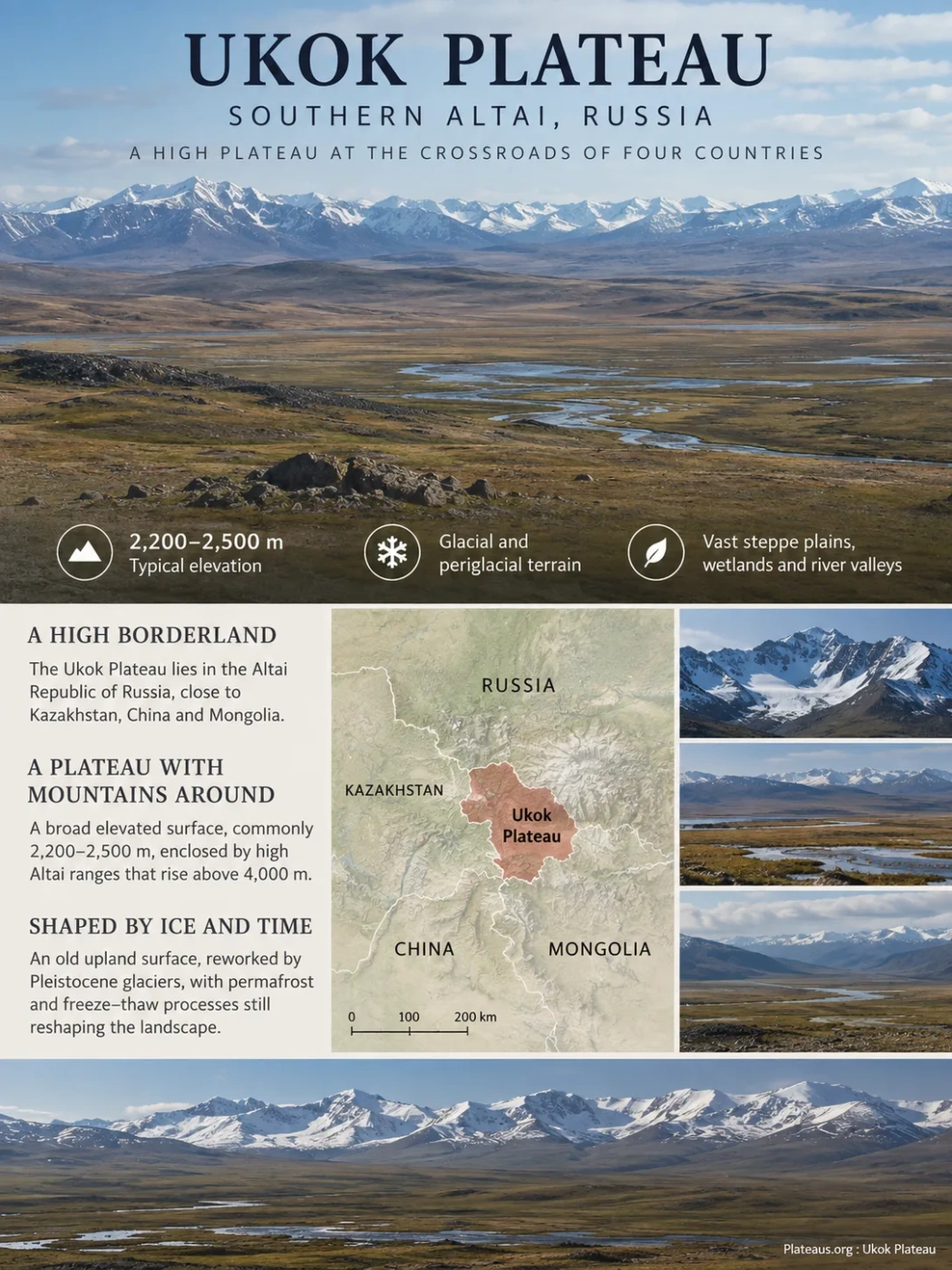
Southern Altai High Plateau
The Ukok Plateau is a cold, high intermontane surface in the Altai Republic of Russia, close to Kazakhstan, China and Mongolia. Much of its open terrain lies around 2,200–2,500 metres above sea level, between mountain ranges that rise far higher. Its broad steppe plains, wetlands and river valleys preserve the imprint of Pleistocene glaciers while permafrost and freeze–thaw processes continue to reshape the ground today.
Glacial and periglacial terrain
Ukok Quiet Zone: 252,904 ha
Ukok Occupies a High Borderland Within the Southern Altai
The Ukok Plateau lies in the southern part of the Altai Republic, within the Russian Federation. It belongs to the high mountain country where the territories of Russia, Kazakhstan, China and Mongolia approach one another. Ukok itself is on the Russian side of these international borders rather than being a plateau shared equally by all four countries.
This position matters physically as well as politically. Ukok occupies an elevated interior surrounded by major Altai ranges. The South Chuya Mountains rise to the north and northeast, while the Kara-Alakha highlands frame part of the west. The Saylyugem, Southern Altai and Tavan Bogd mountain systems form much of the high southern and southeastern setting.
The contrast in relief is large. The main plateau surfaces commonly occupy elevations of roughly 2,200–2,500 m, while surrounding mountain terrain reaches above 4,000 m. Russkiy Shater in the Tavan Bogd massif, for example, reaches about 4,134 m.
Map Context
The locator shows the regional position of Ukok. It should not be read as a precise boundary map of either the physical plateau or the protected Ukok Quiet Zone.
Why Ukok Is a Plateau Despite Its Mountainous Appearance
Ukok is not a flat tableland with a sharp edge. It is better understood as a broad elevated surface enclosed and interrupted by mountain relief. Wide valley floors, gently rolling uplands, wet depressions and residual hills occur within the plateau, while higher ridges rise around and through it.
This is why photographs of Ukok can appear mountainous without conflicting with its classification as a plateau. A plateau does not need to be perfectly level. The defining feature is the presence of an extensive high surface that stands above lower surrounding terrain or occupies a broad elevated position within a mountain system.
High Altai ranges and ridges, locally rising above 3,000–4,000 m.
Broad high ground, commonly around 2,200–2,500 m, with open steppe and gently rolling terrain.
River corridors, wetlands, glacial basins and lower surfaces cut into or lying between the uplands.
Ukok therefore fits an intermontane plateau setting: the plateau surface is part of a much larger mountain landscape but remains distinct from the steeper ranges around it.
An Old Upland Surface Was Reworked by Pleistocene Ice
The present form of Ukok cannot be explained by a single geological event. Parts of the plateau preserve an old erosion and denudation surface that developed over a long period before later mountain uplift, incision and Quaternary glaciation modified it.
Geomorphological descriptions of Ukok identify remnants of old planation surfaces together with residual hills and a wide range of younger glacial, glaciofluvial, alluvial and cryogenic landforms. The landscape is therefore layered: an inherited upland surface forms the broad foundation, while younger processes determine much of what can be seen on the ground today.
Erosion and denudation produced broad surfaces and subdued upland relief before the modern landscape developed.
Mountain glaciers spread through valleys and across parts of the high terrain, eroding bedrock and depositing large volumes of sediment.
Retreating ice left moraines, meltwater deposits, lake depressions and reorganized drainage routes.
Permafrost, seasonal thaw, frost weathering, slope movement and running water continue to modify the inherited glacial terrain.
The Upper Kalguty Basin Preserves the Glacial Record Clearly
The upper Kalguty basin in southeastern Ukok provides one of the clearest studied examples of this landscape history. Its gentler slopes carry glacial till, while multiple moraine complexes record former ice margins. Researchers have also mapped kame terraces and roches moutonnées, the smooth and asymmetric rock forms produced when glaciers move across bedrock.
Some lakes occupying the valley floor may have developed where blocks of buried glacier ice melted out of glacial deposits. This helps explain why small lakes, marshes and poorly drained depressions are closely interwoven with moraine terrain in parts of Ukok.
The contrast between former and modern ice is also important. Small glaciers survive in the high surrounding terrain, but the extensive landforms found across Ukok record glaciation far larger than the ice remaining today.
Permafrost Still Organizes the Ground Surface
Modern Ukok is a strongly permafrost-affected landscape. Permafrost refers to ground that remains at or below freezing for at least two consecutive years. It does not mean that the land surface stays permanently covered by snow or ice.
During the short warm season, an upper active layer can thaw while deeper ground remains frozen. Water movement, repeated freezing and thawing, and the expansion of ground ice then sort, lift and move sediment. Over many cycles these processes produce recognizable landforms.
Repeated frost heaving sorts stones and finer sediment into circles, stripes and other organized surface patterns.
Thermal contraction cracks can fill with ice and gradually produce polygonal networks in suitable frozen sediments.
Seasonally thawed, water-rich soil moves slowly downslope above frozen or poorly drained ground, forming lobes and sheets.
Frost-shattered rock accumulates on cold slopes and high surfaces; some debris masses contain enough ice to form rock-glacier landforms.
In the upper Kalguty basin, mapped periglacial features include blockfields, patterned ground, solifluction lobes, rock glaciers, block slopes and rockfall talus. High-centered ice-wedge polygons have also been documented in alluvial and glacial deposits on parts of the valley floor.
Permafrost conditions are not identical across every part of the plateau. Modelling used for the Kalguty study indicates a strong contrast even within one basin, with extensive continuous permafrost on cold slopes and more discontinuous or sporadic conditions in some valley bottoms.
Permafrost Does Not Create One Uniform Surface
Slope direction, elevation, snow cover, vegetation, sediment type and soil moisture can produce different frozen-ground conditions over short distances. A permafrost map from one part of Ukok should not automatically be applied to the entire plateau.
Cold and Aridity Explain the Plateau’s Open Character
Ukok combines high elevation with a strongly continental interior position. Winters are severe, summers are cool and short, and much of the region receives limited precipitation. In the southeastern plateau, climatic research describes cold-arid conditions with generally negative mean annual air temperatures.
At Bertek, at roughly 2,250 m, a mean annual air temperature of about −8.3°C has been reported. Precipitation varies strongly across the wider southeastern landscape, decreasing from roughly 500 mm toward the northwest to around 100 mm near the Mongolian border in one regional climatic description. Much of that precipitation falls during the warmer part of the year.
This gradient is more informative than assigning one rainfall value to the entire plateau. Ukok is large enough, and its surrounding relief strong enough, for moisture conditions to vary substantially from one sector to another.
Why Forest Does Not Dominate the Plateau Floor
Low temperatures, persistent frozen ground, wind exposure, a short growing season and limited moisture restrict extensive tree growth across much of the high surface. The result is an open mosaic of cold steppe, alpine meadow, sedge vegetation, marsh and sparsely vegetated frost terrain.
Wetlands can occur next to relatively dry steppe because moisture distribution depends strongly on relief. Water collects on low-gradient valley floors and in poorly drained depressions, while slightly raised surfaces can remain much drier. The combination produces the broad grassland-and-wetland scenery characteristic of central Ukok.
Rivers and Lakes Follow a Landscape Inherited From Ice
Water on Ukok moves through broad glacial valleys, moraine complexes and low depressions rather than across a simple flat surface. Snowmelt, seasonal precipitation and meltwater from the remaining high-altitude ice feed streams that cross the plateau and eventually enter the larger Altai river network.
The Ak-Alakha is one of the central drainage features. The Kalguty and several smaller rivers feed the same connected system, and the Ak-Alakha continues toward the Argut. The Argut joins the Katun, placing much of Ukok within the wider Ob River drainage basin.
Seasonal melt and precipitation supply streams, marshes and lake basins across the plateau.
Local channels, including the Kalguty system, converge toward the Ak-Alakha drainage.
Water leaving the plateau enters the Argut and then the Katun river system.
The Katun becomes part of the headwater network of the Ob, linking Ukok to one of northern Asia’s major drainage systems.
Lake Ukok and Kaldzhin-Kul Occupy Different Glacial Settings
Recent field research on plateau lakes provides precise measurements for two of Ukok’s better documented water bodies.
| Lake | Elevation | Area | Landscape Setting | Outlet |
|---|---|---|---|---|
| Lake Ukok | 2,416 m | 2.4 km² | Small glacier-eroded depression with moraine deposits and alpine-meadow shores | Kara-Bulak toward the Ak-Alakha |
| Kaldzhin-Kul | 2,402 m | 3.9 km² | Low, marshy basin linked with the nearby Kaldzhin-Kul-Bas system | Kaldzhin River toward the Ak-Alakha |
River form also changes with local relief. In the upper Kalguty basin, large alluvial fans extending from steep side valleys can push against the main channel and alter its course. Braided channels in tributary valleys record strong seasonal flows, while parts of the main Kalguty occupy a broad multi-channel valley floor.
The Ukok Quiet Zone Covers Part of the Plateau
The name Ukok Plateau should not be treated as interchangeable with Ukok Quiet Zone. The first is a physical geographic region; the second is a defined protected area within it.
The Ukok Quiet Zone is one of the three component areas of the Golden Mountains of Altai World Heritage property, inscribed in 1998. The other components are centered on the Altaisky protected area and Lake Teletskoye, and the Katunsky protected area around the Belukha Mountain region.
Ukok Quiet Zone World Heritage component
Entire Golden Mountains of Altai World Heritage property
World Heritage inscription
Three Different Geographic Ideas
Ukok Plateau is the landform and regional highland. Ukok Quiet Zone is the protected component located on the plateau. Golden Mountains of Altai is the much larger serial World Heritage property containing Ukok and two other separated component areas.
The World Heritage designation reflects the broader Altai region’s exceptional sequence of mountain vegetation zones and its habitat for rare and endangered species. The protected mountain system includes steppe, forest-steppe, forest, subalpine and alpine environments and supports species such as the snow leopard.
Frozen Archaeological Sites Are Part of Ukok’s Physical Geography
Ukok is widely known for archaeological remains of the Pazyryk culture, but their unusual preservation is inseparable from the plateau’s cold-ground processes. Burial mounds built from stone can produce thermal conditions that differ from the surrounding terrain.
During winter, cold air can circulate through spaces between stones and cool the ground beneath a mound efficiently. In summer, the same coarse stone layer reduces heat transfer into the buried soil. Under suitable conditions, this process promotes the development and persistence of subsurface ice lenses.
That localized frozen environment preserved organic materials that would normally decay. Pazyryk frozen tombs in the Altai have yielded wood, felt, textiles, leather, clothing, horse equipment, human remains and other materials. The preservation system is therefore an unusual intersection of archaeology, sediment, ground ice and mountain climate.
Archaeological surveys carried out on Ukok in the early 1990s mapped more than 400 sites of different periods and types. Among the best-known discoveries was a frozen Pazyryk burial excavated in the Ak-Alakha area in 1993, commonly called the Ukok Princess or Siberian Ice Maiden.
The importance of the find is not limited to the burial itself. It demonstrates how a high plateau environment can preserve biological and cultural material through a ground-temperature regime created jointly by regional permafrost, burial construction and local sediment conditions.
Thawing Ground Can Change the Preservation System
Frozen archaeological deposits depend on temperatures remaining low enough to preserve their internal ice. If the seasonally thawed layer deepens or an ice-bearing burial mound warms, previously frozen organic material can become exposed to liquid water, oxygen and biological decay.
The vulnerability is not identical for every mound. Stone thickness, snow accumulation, slope exposure, sediment moisture and the geometry of the burial structure can all affect its internal thermal regime. This makes frozen-tomb preservation a local ground-temperature problem rather than a simple measure of regional air temperature.
The Long-Running Altai Gas Pipeline Issue Changed in 2026
For many years, conservation assessments of the Golden Mountains of Altai repeatedly considered the possibility that the proposed Altai Main Gas Pipeline could cross or affect the World Heritage property. The potential route was especially relevant to Ukok because of its position along the Russian border toward China.
The status changed in 2026. The World Heritage Committee recorded that the proposed Altai Main Gas Pipeline had been excluded from the Russian federal territorial planning scheme. The decision treated this as addressing the long-standing concern over the project’s possible adverse effect on the World Heritage property.
This change is narrower than saying that every conservation issue in the Golden Mountains of Altai has been resolved. It means that the pipeline project which had appeared repeatedly in earlier conservation decisions was no longer included in that federal planning scheme, removing a major long-running infrastructure concern directly associated with the Ukok border corridor.