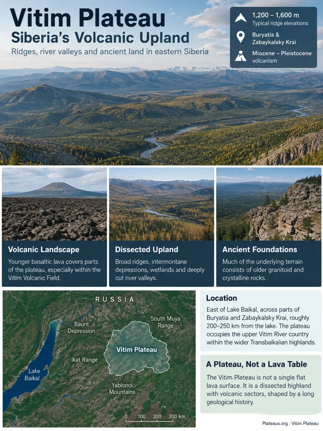
Eastern Siberia · Volcanic and Dissected Upland
The Vitim Plateau is a broad upland east of Lake Baikal where rounded ridges, intermontane depressions, deeply cut river valleys and permafrost terrain lie across an old continental foundation partly covered by much younger basaltic lava. Its best-known volcanic rocks record Miocene to Pleistocene eruptions, but the volcanic field is only one part of a much longer geological history extending deep into the crust and mantle beneath Transbaikalia.
Broad ridges often around 1,200–1,600 m
Miocene–Pleistocene volcanism
The Vitim Plateau Is Not a Single Flat Lava Table
The word plateau can give the wrong impression of Vitim. Its surface is not a continuous level table. Broad, comparatively smooth ridges alternate with intermontane depressions, wetlands, river valleys and locally more rugged uplands. Many geographic descriptions place the main rolling ridges broadly around 1,200 to 1,600 metres above sea level, although elevations vary across the wider region and some geological studies use lower values for particular lava-covered sectors.
This rolling structure matters because it separates the geographic plateau from the volcanic landforms superimposed on it. Much of the underlying terrain consists of older granitoid and crystalline rocks. Younger basaltic lava occupies parts of the plateau, especially within the better-studied Vitim Volcanic Field. Rivers have since cut through both old basement terrain and younger deposits, producing a landscape that is better described as a dissected highland with volcanic sectors than as one lava-built surface.
Elevation Note
The 1,250 m elevation sometimes shown for “Vitim” in volcano databases refers to the volcanic-field record and should not be treated as the average elevation of the entire Vitim Plateau. The broader upland contains ridges, basins and valleys at different heights.
Where the Upland Fits East of Lake Baikal
The Vitim Plateau lies in eastern Siberia, across parts of the Republic of Buryatia and Zabaykalsky Krai. Geological descriptions commonly place its central volcanic terrain roughly 200–250 km east of Lake Baikal. The plateau occupies the upper Vitim River country within the wider Transbaikalian highlands.
Its physical setting is framed by several mountain and drainage systems rather than by one sharp plateau rim. The South Muya Range rises toward the north, the Ikat Range lies to the west, and the Yablonoi Mountains form an important southern highland boundary. Toward the east, the plateau grades into terrain associated with the Kalakan and Karenga drainage systems.
The Baunt Depression adds another level of relief in the northwest. Here lower basin terrain, lakes, wetlands and river corridors interrupt the upland surface. This combination of raised ridges and enclosed or partly enclosed depressions is one reason Vitim can appear mountainous or basin-like at local scale even though it is mapped regionally as a plateau.
Lake Baikal and the Ikat Range
Rolling ridges, volcanic terrain, depressions and the upper Vitim drainage
Karenga–Kalakan drainage country and adjoining Transbaikalian highlands
Vitim Plateau and Vitim Volcanic Field Are Different Geographic Units
The most important distinction in Vitim geography is between the Vitim Plateau and the Vitim Volcanic Field. The names are sometimes used loosely in geological literature, and “Vitim lava plateau” may refer specifically to lava-covered terrain rather than the whole physiographic upland.
Vitim Plateau
- A broad physiographic upland in eastern Siberia.
- Includes ridges, depressions, rivers, wetlands and non-volcanic bedrock.
- Contains extensive older granitoid and crystalline geological foundations.
- Cannot be represented by one volcanic-field elevation or area measurement.
Vitim Volcanic Field
- A Cenozoic volcanic province occupying part of the wider upland.
- Covers about 4,500 km² in modern volcanic compilations.
- Contains basaltic lava flows and groups of pyroclastic cones.
- Records volcanism from the Miocene into the Pleistocene.
The approximately 4,500 km² figure therefore describes the volcanic field, not a secure total area for the entire Vitim Plateau. Published geographic and geological works use different regional boundaries and sometimes different meanings for “plateau,” “highland” and “lava plateau.” A single precise area for the broader landform can create false accuracy unless the mapped definition is specified.
Common Mix-Up
Vitim is partly volcanic, but the whole plateau was not built by the known Cenozoic lava field. The younger volcanic rocks rest within a much older and more varied continental landscape.
The Rocks Record Several Separate Magmatic Eras
Vitim cannot be explained by one eruption episode. Its geology records magmatism separated by tens or hundreds of millions of years. Deep crustal rocks, alkaline intrusions and Cenozoic basalt belong to different stages of the region’s evolution.
Late Paleozoic Crust and the Angara–Vitim Magmatic Province
Granitoids of the large Angara–Vitim batholith form an important part of the regional geological foundation. Recent work on lower-crustal xenoliths from Vitim has also identified zircon ages around 280 million years, tying deep mafic crust to this Late Paleozoic magmatic episode.
Permian–Triassic Alkaline Magmatism
Alkaline rock bodies from several parts of the Vitim Plateau record another distinct magmatic phase. This episode predates the familiar basaltic volcanic field by more than 200 million years.
High-Magnesium Miocene Volcanism
Early parts of the well-studied Cenozoic sequence include high-Mg basanites, basalts and picrobasalts derived from mantle melting beneath the region.
More Voluminous Basaltic Eruptions
A later mid-Miocene phase produced larger volumes of moderate-Mg basaltic lava, helping spread volcanic cover across existing upland relief.
Younger Lava Flows and Volcanic Centres
Volcanism continued intermittently after the main Miocene episodes. Pleistocene units mapped in the volcanic field include reported ages broadly between about 1.2 and 0.5 million years.
The sequence shows why calling Vitim simply a “volcanic plateau” loses much of its geological meaning. The Cenozoic lavas are a young surface expression placed over crust assembled and modified during much older events.
Miocene Lava Spread Across an Existing Landscape
The main Cenozoic eruptions did not begin on a blank, level surface. Magma rose through an already developed highland containing ridges, valleys, sediment-filled depressions and drainage routes. Fluid basaltic lava could spread laterally through lower ground while individual vents produced more localized volcanic forms.
The volcanic field contains several groups of eruptive centres rather than one dominant volcano. Pyroclastic cones occur alongside broad lava-covered terrain. Basalt and picrobasalt are major rock types, while trachybasalt, basanite and smaller amounts of basaltic andesite or andesite add compositional variety.
This distributed style of volcanism helps explain the landscape today. A visitor to a lava plateau does not necessarily encounter one large cone rising above everything else. Much of the volcanic record can survive as subdued lava surfaces, low volcanic remnants, resistant bedrock in valley walls and buried layers exposed only where erosion or drilling cuts through younger material.
The Youngest Known Activity Is Pleistocene, Not Holocene
The Vitim Volcanic Field is not currently classified as a Holocene eruptive centre. Modern volcanic databases list its last known eruption period as Pleistocene and report no known eruptions during the Holocene, the roughly 12,000-year interval that contains the eruptive histories of volcanoes normally treated as geologically recent in global volcano catalogues.
Describing the field as “active today” would therefore be misleading. Its volcanic character is unmistakable, but the preserved cones and lava flows belong to an older phase of the landscape.
Why Volcanism Occurred Away From the Main Baikal Rift Axis
Vitim is especially useful for understanding eastern Siberian tectonics because its volcanic field lies well east of the central Baikal Rift. Volcanism around the Baikal region is not restricted to the narrow depression occupied by Lake Baikal itself. Eruptive centres occur across a much wider zone, often offset from the main rift axis.
This spatial pattern has produced a long-running debate over what generated the magma. Earlier geochemical work on Vitim argued for unusually hot mantle and a mantle-plume influence beneath the Baikal region. Broader regional studies later emphasized extension, shearing and tectonically controlled decompression of the upper mantle, while still allowing for hotter upwelling mantle at greater depth.
Stretching and faulting can reduce pressure on mantle material, promote partial melting and guide magma toward the surface.
Geochemical and thermal evidence indicates unusually hot sub-lithospheric material affected the region during Cenozoic volcanism.
Later models place Vitim within a wider Central and East Asian mantle system rather than requiring a simple vertical plume directly beneath every volcanic field.
The evidence therefore does not support a simple statement that “the Vitim Plateau formed because of the Baikal mantle plume.” The plateau itself is older and more complex, while the origin of its Cenozoic volcanism involves interaction among lithospheric structure, rifting, mantle temperature and asthenospheric movement.
Mantle Xenoliths Turn Vitim Into a Window Below the Crust
Some of Vitim’s basalt contains mantle xenoliths: pieces of deep rock torn from the walls of the magma’s ascent path and carried rapidly toward the surface. These fragments are one of the main reasons the Vitim Volcanic Field receives attention far beyond regional geomorphology.
Peridotite and related rocks form part of the lithospheric mantle beneath the region.
Ascending magma detaches fragments from mantle and lower-crustal rocks.
Rapid transport preserves mineral and chemical evidence from depths that cannot be sampled directly.
Geochemists use the xenoliths to reconstruct melting, metasomatism, temperature and mantle evolution.
Peridotite xenoliths from Vitim include lherzolites that preserve information about the subcontinental lithospheric mantle. Their minerals show that the mantle beneath the plateau did not behave as a uniform source. Parts experienced partial melting, while later fluids or melts altered mineral chemistry through metasomatism.
A 2024 geochemical study found that the sampled Vitim lherzolites retain relatively fertile mantle characteristics and generally record less than about 10% residual partial melting. The study also found systematic differences between material carried upward by Miocene and Pleistocene magmas. The younger Pleistocene xenoliths sampled comparatively shallower and less metasomatized mantle than the older Miocene suite.
The researchers interpreted this change through time as evidence for progressive asthenospheric upwelling. Rather than being only remnants of eruptions, the lava flows therefore preserve a vertical sampling system through the mantle beneath the plateau.
New Lower-Crust Evidence Extends the Story to About 280 Million Years Ago
Mantle rocks are not the only deep fragments carried by Vitim magmas. Late Cenozoic basalts also contain pieces of mafic lower and middle crust, including granulitic and gabbroic material. These xenoliths allow the deeper structure beneath the plateau to be tested independently of surface geology.
Research published in 2026 dated zircon from Vitim lower-crustal xenoliths to approximately 280 million years ago. That age corresponds closely with the Late Paleozoic Angara–Vitim granitoid province. The xenoliths were also found not to be simple accumulations crystallized from the much younger Cenozoic basalts that brought them upward.
What the 2026 Evidence Changes
The Cenozoic lava did more than cover the landscape. By carrying old crustal fragments to the surface, it exposed evidence that part of the deep crust beneath Vitim was assembled during Late Paleozoic magmatism hundreds of millions of years before the visible basalt field formed.
This creates a useful vertical picture of Vitim: old lower crust and granitoid provinces at depth, younger phases of alkaline magmatism above that foundation, then Miocene–Pleistocene basaltic activity sampling both crust and mantle as magma rose.
The Vitim River Organizes Much of the Plateau Landscape
The plateau is closely tied to the headwaters and upper course of the Vitim River, one of the large tributaries of the Lena. The Vitim begins where the local China River and Vitimkan River meet, then follows a broad course through the upland before eventually continuing north toward the Lena system.
Their confluence forms the upper Vitim.
The river crosses and curves through the dissected upland, interacting with volcanic and non-volcanic terrain.
The river continues north beyond the plateau through increasingly rugged terrain.
Vitim ultimately joins the Lena, connecting the plateau to Arctic Ocean drainage.
The Tsipa, Tsipikan and Amalat systems further divide the highland into ridges, valleys and basin floors. Around the Baunt Depression, low-gradient terrain supports lakes and marshy ground, while other streams occupy more deeply incised channels through resistant upland rocks.
River erosion is therefore not a minor surface detail. It is one of the main processes that converted an older raised landscape and later lava-covered surfaces into the broken relief visible today.
Old Drainage Survives Beneath the Modern Surface
Parts of the Vitim Plateau preserve more than one generation of river valleys. Geological work in the China tectonic depression has distinguished shallow Holocene valley deposits from much deeper Pliocene–Pleistocene deposits occupying preglacial paleovalleys.
Some of these old valley systems lie more than 25 metres beneath the modern surface. Their position shows that today’s drainage network is only the latest layer of a landscape that has repeatedly been buried, incised and reorganized.
Volcanic and volcano-sedimentary sequences elsewhere on the plateau provide a related record. Boreholes have revealed Cenozoic successions containing volcanic units interbedded with sediments deposited in basins and valleys. Lava, erosion and sedimentation therefore operated together rather than in separate geological worlds.
Valleys and depressions develop across pre-existing bedrock.
Sediment and, locally, volcanic material accumulate across lower terrain.
Younger rivers establish new channels and cut into the inherited surface.
Permafrost Changes How Water Moves Across the Plateau
The southern margin of the broad eastern Siberian permafrost zone crosses the Vitim Plateau. This makes frozen-ground conditions especially variable from one part of the landscape to another. Permafrost may occur beneath forest, meadow-steppe and low-lying terrain, while its depth and continuity change with slope position, vegetation, soil material and local climate.
During the warm season, the upper soil layer thaws while deeper ground may remain frozen. Where that frozen layer restricts downward drainage, water remains closer to the surface. Low-gradient depressions can consequently remain much wetter than nearby ridges and better-drained slopes.
Better drainage and thinner surface deposits can favour relatively dry forest or open upland terrain.
Aspect, snow cover, soil thickness and vegetation create strong differences in seasonal thaw depth.
Low relief combined with frozen or poorly permeable ground promotes wet soils, meadows, marshes and shallow-water environments.
Field research in the southern Vitim Plateau has examined a sequence running from larch-covered upland through birch forest and meadow-steppe to a former thermokarst-lake setting. The close spacing of these environments shows how rapidly surface conditions can change across a relatively small difference in elevation and drainage.
Permafrost also affects erosion and sediment movement. Freeze–thaw processes disturb surface material, while seasonally saturated ground changes how runoff reaches streams. The plateau’s modern relief therefore reflects not only ancient tectonics and volcanism but also an active cold-region surface system.
Larch Taiga, Meadow-Steppe and Wetlands Follow the Relief
Vegetation across Vitim is closely tied to topography and frozen-ground conditions. Larch-dominated taiga occupies large areas of the upland, accompanied locally by birch woodland and shrub communities. Wetter depressions support meadows, marsh vegetation and other moisture-tolerant communities.
The southern part of the plateau also reaches a transition toward forest-steppe conditions. Meadow-steppe vegetation can occur directly on permafrost soils, a combination documented in modern vegetation studies from the Vitimskoye Plateau. These communities are not simply controlled by latitude. Ground temperature, slope exposure, soil moisture and the depth of seasonal thaw all help determine where forest gives way to more open vegetation.
This creates a recurring landscape pattern: wooded ridges and slopes can stand beside wet basin floors, while relatively dry meadow-steppe occurs in another nearby setting. The plateau therefore contains ecological contrasts that mirror its physical relief and subsurface conditions.
Basalt, Old Crust and Frozen Ground Produce Different Landscapes Side by Side
Vitim’s surface becomes easier to understand when its geological layers are considered together rather than separately. Resistant granitoid uplands preserve broad ridges. Basaltic eruptions covered parts of that older surface and filled some low areas. Rivers cut across both materials. Sediment accumulated in depressions, and permafrost later altered drainage, soil development and modern vegetation.
Late Paleozoic and older crust, including rocks associated with the Angara–Vitim magmatic province.
Granitoid and crystalline terrain shaped into ridges, basins and drainage systems.
Miocene to Pleistocene lava flows and dispersed volcanic centres occupy only part of the broader plateau.
River incision, sedimentation, seasonal thaw, permafrost and vegetation continue to reshape the inherited relief.
This layered structure explains why nearby parts of Vitim can look unrelated: a forested granitoid ridge, a basalt-covered upland, a deeply cut river corridor and a wet permafrost depression can all belong to the same regional plateau system.