Northern Siberia · Ancient Cratonic Upland
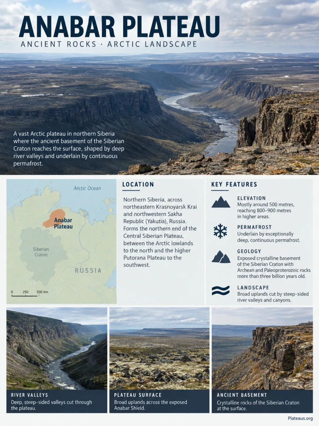
The Anabar Plateau is a low Arctic plateau in northern Siberia where the ancient crystalline basement of the Siberian Craton reaches the surface. Broad uplands commonly around several hundred metres high are cut by deep river valleys, underlain by exceptionally deep permafrost, and bordered by younger sedimentary rocks. This overlap between an exposed Precambrian shield and a strongly dissected plateau gives Anabar a geological character unlike the higher volcanic plateaus farther west.
Where the Anabar Plateau Fits Into Northern Siberia
The Anabar Plateau lies north of the Arctic Circle across northeastern Krasnoyarsk Krai and northwestern Sakha Republic (Yakutia), Russia. It forms the northern end of the broader Central Siberian Plateau system, between the lowlands of Arctic Siberia and the interior uplands farther south.
The regional boundaries are better understood as transitions than as sharp lines. The North Siberian Lowland and the Taymyr Depression lie to the north. To the southwest, Anabar grades toward the much higher Putorana Plateau. The distinction between the two uplands is especially important: Putorana is dominated by thick volcanic successions and considerably higher relief, while Anabar is closely tied to an exposed block of ancient continental basement.
North Siberian Lowland and Taymyr Depression
Low Arctic upland built across the exposed Anabar Shield
Transition toward the higher Putorana Plateau
Much of the plateau surface lies around 500 metres above sea level, while higher sectors reach roughly 800–900 metres. Those numbers can make Anabar sound comparatively subdued, but elevation alone gives a poor impression of its terrain. Rivers have cut steep-sided valleys and canyons through the upland, creating strong local relief within a region that remains a plateau at the broader landscape scale.
Anabar Plateau and Anabar Shield Describe Different Things
The names Anabar Plateau and Anabar Shield are closely connected because they occupy much of the same ground. They are not interchangeable terms.
Anabar Plateau
- A physical landform and physiographic region.
- Defined by its broad elevated surface and surrounding relief.
- Includes river valleys, plateau surfaces, slopes and sediment-covered margins.
- Describes what the landscape looks like at regional scale.
Anabar Shield
- A geological exposure of the Siberian Craton’s crystalline basement.
- Defined by ancient rocks and crustal structure rather than surface shape.
- Contains Archean and Paleoproterozoic metamorphic complexes.
- Describes what lies beneath and within the exposed crust.
The unusual feature at Anabar is their geographic overlap. Across much of Siberia, the ancient cratonic basement is buried beneath younger sedimentary or volcanic rocks. At Anabar it is exposed, giving geologists direct access to rocks that preserve some of the oldest stages in the development of the Siberian Craton.
A Crustal Record Extending Back More Than Three Billion Years
The oldest part of the Anabar story cannot be reduced to a single age. Zircon dating shows that the shield contains material produced during several periods of crust formation, recycling and high-grade metamorphism.
Very Early Continental Crust
Ancient zircon components record crust-forming processes during the Paleoarchean and later Archean. These ages place parts of the Anabar crust among the oldest known components of the Siberian Craton.
Major Crust Formation and Reworking
Large zircon populations record another major period of crustal growth and recycling. Much of the shield’s Archean history reflects repeated transformation rather than preservation of one unchanged block of primordial crust.
High-Grade Metamorphism
Parts of the shield underwent intense granulite-facies metamorphism during Paleoproterozoic crustal reorganization. Geological studies place an important stage in the assembly and stabilization of the Siberian Craton near this interval.
Erosion Exposes the Basement
Long periods of burial, erosion and regional landscape development eventually left ancient crystalline rocks exposed across the plateau while younger sedimentary successions remained around its margins.
The 3.8-Billion-Year Zircon Needs Careful Interpretation
A zircon study identified a single core with an age close to 3.8 billion years. That grain may represent exceptionally old lithospheric material, but researchers could not rule out an exotic origin. It should therefore not be used to describe the entire Anabar Plateau, or even the whole Anabar Shield, as 3.8 billion years old. Multiple zircon populations provide firmer evidence for crustal components extending back about 3.4–3.6 billion years.
The Plateau Has an Ancient Core and Younger Sedimentary Margins
Much of the central shield exposes high-grade metamorphic rocks. Gneisses, crystalline schists and granulite-related rocks are widespread, accompanied by granitic intrusions and other igneous bodies. Some Anabar granulites record very high metamorphic temperatures, preserving evidence of conditions deep within ancient continental crust.
The outer parts of the plateau are geologically different. Proterozoic and Lower Paleozoic sedimentary rocks occur around the crystalline basement, including extensive carbonate units. Cambrian carbonate rocks are exposed in parts of the eastern plateau where tributaries of the Anabar River have cut through the sedimentary cover.
Younger sedimentary cover, including carbonate rocks
Exposed gneiss, schist, granulite and intrusive crystalline rocks
Basement passes beneath younger platform cover
This arrangement explains why a journey across Anabar can cross very different rock landscapes without leaving the same broad plateau. The surface landform spans both exposed basement and areas where younger formations still cover or flank it.
A Broad Plateau Surface Cut Open by Rivers
Anabar is not a smooth tableland. Its regional surface is comparatively broad and gently sloping, but major rivers and tributaries have cut deeply into it. The result is a dissected plateau: extensive upland remnants separated by valleys, canyon-like corridors and steep rock walls.
This distinction matters when interpreting photographs or topographic maps. A view from inside one of the river valleys can resemble mountainous canyon country, while a regional elevation model reveals the wider upland surface from which those valleys were excavated.
The plateau retains extensive elevated terrain with comparatively modest relief when viewed across large distances.
Rivers cut downward through the upland, separating plateau surfaces and concentrating relief along valleys.
Valley sides provide natural cross-sections through crystalline and sedimentary formations that are less visible on flatter surfaces.
The Main Drainage Relationships
| River or Drainage | Relationship to the Anabar Plateau |
|---|---|
| Bolshaya Kuonamka | Rises on the plateau and forms the upper course of the Anabar River system. |
| Kotuy | Crosses the western part of the plateau and occupies one of its major incised river corridors. |
| Kotuykan | Drains high parts of the plateau before joining the Kotuy; its valley is strongly associated with steep cliffs and exposed rock sections. |
| Popigai River | Has headwaters in the northeastern part of the plateau region; it should not be confused with the nearby Popigai impact structure. |
| Olenyok Basin Headwaters | Streams along the southeastern side connect portions of the upland to the Olenyok drainage system. |
The Kotuykan Valley Reveals the Interior of the Plateau
The Kotuykan is especially useful for understanding Anabar’s relief because its valley cuts through the higher western part of the plateau. Instead of seeing only the upper surface, the river corridor exposes steep rock faces, weathered slopes and geological contacts.
These valleys also show why rock resistance matters. Hard crystalline rocks can maintain steep walls and prominent outcrops, while sedimentary successions may produce different cliff forms, ledges and weathering patterns. Frost action adds another layer of modification by widening fractures and producing angular debris on exposed slopes.
River incision therefore does more than divide the plateau. It exposes the geological structure that gives Anabar much of its scientific value.
Permafrost Extends Far Beneath the Surface
Anabar lies within the zone of continuous permafrost, but the frozen subsurface is more complicated than a single thickness figure suggests. Ground temperature, bedrock type, elevation, fractures, river valleys and local geothermal conditions all affect the depth and structure of frozen ground.
A study on the eastern margin of the plateau reported permafrost about 700–800 metres thick, with seasonal thaw generally no deeper than about 0.8 metre at the investigated site. Broader geocryological work on the Anabar Shield describes a cryolithozone exceeding 1,000 metres in places, while geophysical estimates indicate still greater local thicknesses in parts of the shield.
Permafrost Measurement Note
Values reported for one borehole, study area or sector should not be treated as a uniform thickness for the whole Anabar Plateau. Published estimates differ because some refer to ice-bearing permafrost near the surface, others to the full zone of rocks remaining below 0°C, and others to specific geological settings within or around the shield.
Why the Frozen Zone Can Be So Deep
The Arctic climate is only part of the explanation. The Anabar Shield also has unusually low geothermal heat flow. With less heat moving upward from Earth’s interior, frozen conditions can extend much farther downward than they would in crust with a higher geothermal gradient.
Long, severe winters keep mean ground temperatures low.
The old cratonic crust supplies comparatively little geothermal heat.
Subzero conditions can persist through a very thick interval of rock.
At the surface, only a relatively shallow active layer thaws during summer. Frozen material beneath it restricts deep drainage, affects soil moisture and helps control slope processes. Along rivers and other locally warmer or better-drained settings, the thermal structure can differ markedly from exposed plateau tops.
Larch Forest Reaches Into a Harsh Forest–Tundra Boundary
The plateau is not uniformly treeless tundra. Dahurian larch (Larix gmelinii) occupies protected and relatively well-drained locations, especially in valleys and lower terrain. Mosses and lichens are common ground cover, while more exposed and higher areas shift toward open forest-tundra and tundra vegetation.
The Anabar Plateau has been used to study the northern and upper limits of larch forest because vegetation responds strongly to small differences in elevation, snow cover, drainage and temperature. One well-studied forest–tundra zone in the Kotuykan–Kotuy watershed spans approximately 170–450 metres in elevation. That range describes the research transects, not a universal vegetation boundary for the entire plateau.
Tree-ring and subfossil wood records show that the forest boundary has moved through time. Strong tree mortality between the sixteenth and early nineteenth centuries accompanied a downward retreat during the Little Ice Age, while later regeneration altered the position and structure of the tree line. Recent ecological work continues to document larch expansion into tundra landscapes in parts of the northwestern plateau.
The pattern is strongly controlled by terrain. River valleys can provide drainage and shelter that favor larch growth, while exposed plateau surfaces remain colder and more wind-affected. Vegetation boundaries therefore follow local landform conditions rather than a simple horizontal line across the map.
Ice Sheets Modified Anabar Before Modern Rivers Shaped Its Valleys
River erosion is prominent today, but it is not the only process responsible for the plateau’s modern form. Glacial deposits and landforms show that the Anabar region was affected repeatedly during the Pleistocene.
Research on the northeastern Central Siberian Plateau has identified erosional and depositional glacial features across Anabar, including marginal formations left by advancing ice, landforms associated with stagnant or dead ice, and transported glacial erratics. Reconstructions indicate that major ice masses advanced into the region from the northwest, linked to much larger Arctic ice-sheet systems.
The plateau itself influenced how the ice moved. During phases of deglaciation, elevated Anabar terrain acted as an obstacle while ice streams continued through lower depressions. More recent work on Arctic glaciated landscapes also identifies Anabar as one of the rocky plateau areas that could support local ice dispersal centres during parts of the Ice Age.
Large Pleistocene ice masses reached the Anabar region from the Arctic side of Siberia.
Stagnant ice, marginal deposits and transported erratics remained as the larger ice cover broke apart.
Rivers, frost weathering and periglacial slope processes continued to dissect and rework the inherited terrain.
Several Geological Timescales Meet in One Landscape
One reason Anabar is difficult to describe with a single formation label is that its present landscape combines features created during vastly different intervals. The plateau surface, exposed shield, sedimentary margins, glacial deposits and modern frozen-ground processes are not products of one event.
| Time Scale | Main Process | Expression in the Anabar Region |
|---|---|---|
| More than 3 billion years | Early crust formation | Ancient zircon and crystalline basement preserved within the Anabar Shield. |
| Archean to Paleoproterozoic | Crustal reworking and metamorphism | Gneiss, granulite and other high-grade metamorphic complexes. |
| Proterozoic and Paleozoic | Sedimentation over the cratonic margin | Younger sedimentary and carbonate units around parts of the shield. |
| Pleistocene | Glaciation and deglaciation | Glacial deposits, erratics and landforms produced or modified by ice. |
| Present landscape | River incision, frost weathering and seasonal thaw | Deep valleys, cliffs, unstable frost-affected material and strongly dissected plateau surfaces. |
Popigai Is Nearby, but It Did Not Create the Anabar Plateau
The Popigai impact structure lies near the northeastern margin of the Anabar Shield and is one of the largest confirmed impact structures on Earth. Its roughly 100-kilometre-scale structure formed about 35.7 million years ago when an extraterrestrial body struck northern Siberia.
That event is geologically young compared with the Anabar basement. The crust beneath the region had already existed for billions of years, and the broader plateau cannot be explained as an impact landform.
Do Not Confuse the Two Landscapes
Anabar Plateau: a regional upland associated with the exposed Siberian Craton and a long history of erosion, glaciation, river incision and permafrost development.
Popigai impact structure: a much younger impact feature formed about 35.7 million years ago near the northeastern side of the Anabar Shield.
The age contrast is extreme: Popigai records a single event measured in tens of millions of years, while zircon and metamorphic rocks within the Anabar Shield preserve crustal history measured in billions. Their proximity makes the region geologically unusual, but it does not make the plateau an impact-created landform.